| Title Sonoma State Historic Park, General Vallejo Home Orchard Proposal | |
|
Author John J Finnigan American River College, Geography 350: Data Acquisition in GIS; Fall 2018 | |
|
Abstract A proposal has been put forth to re-establish the fruit orchards (apple or pear in large area or apricot, peach or cherry in the small area) which used to exist at General Vallejo’s Home in Sonoma State Historic Park. | |
|
Introduction While working for California Department of Parks and Recreation, I was tasked to draw out an area for a proposed re-establishment of the historic orchard at General Vallejo’s Home in Sonoma State Historic Park. This proposal is to bring this section of Sonoma State Historic Park more in line with the vision of General Vallejo’s Home as it was 175 years ago. | |
|
Background | |
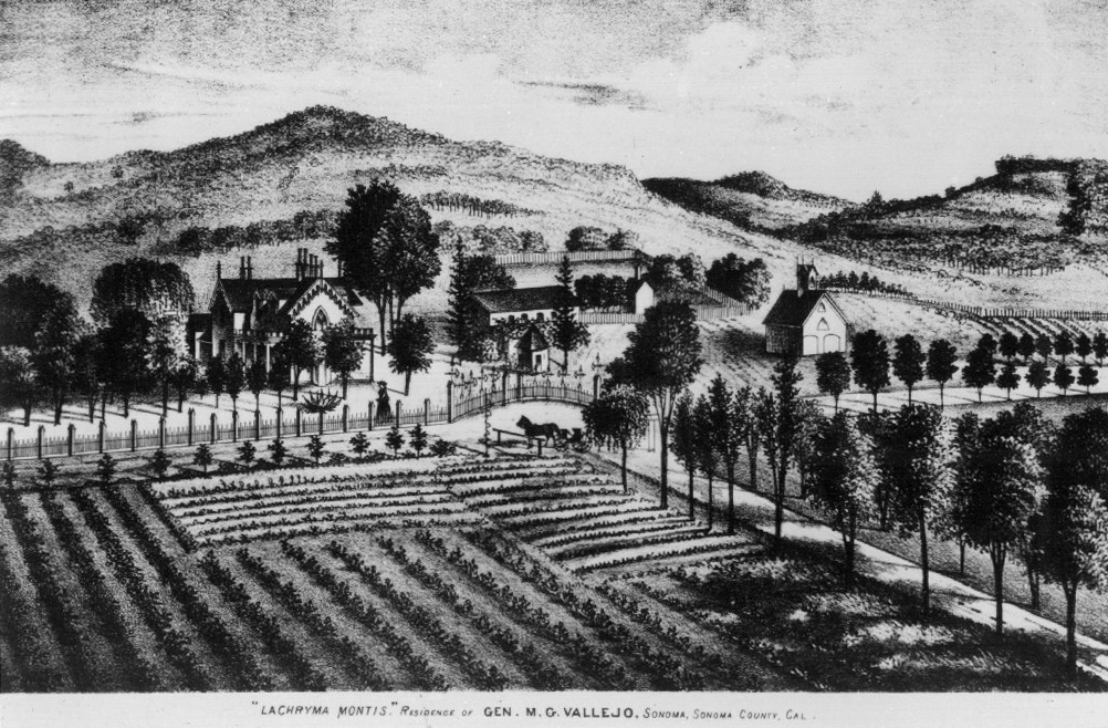
| In 1843 General Mariano Guadalupe Vallejo was given 84,000 acres of land (most of which he eventually lost in a 1862 Supreme Court decision) and moved onto his estate in 1852 entitled Lachryma Montis (Latin for Mountain Tear or Crying Mountain). “The exact composition and size of Vallejo’s orchards during the 1850s is not known. He had planted orchards by this time and given the size and significance of his vineyards during this period (in relation to others in Sonoma), it seems reasonable to think that his orchard was also one of the more established.” Over time Vallejo lost nearly all of his vast land holdings and was even forced to sell the vineyard and other "nonessential" acreage at the estate. In 1933 the state of California acquired a portion of General Vallejo’s property and was eventually incorporated into the Sonoma State Historic Park. The re-establishment of the orchards was proposed in the 2007 “Cultural Landscape Report Lachryma Montis (General Vallejo Home) Sonoma State Historic Park”, but the proposal was never given a greenlight. Lynn Lutz, who was originally hired to implement the proposal, has been pushing in the past year or two to start with the plan. This GIS is but a first, small part of that implementation. |
|
|
Methods | |
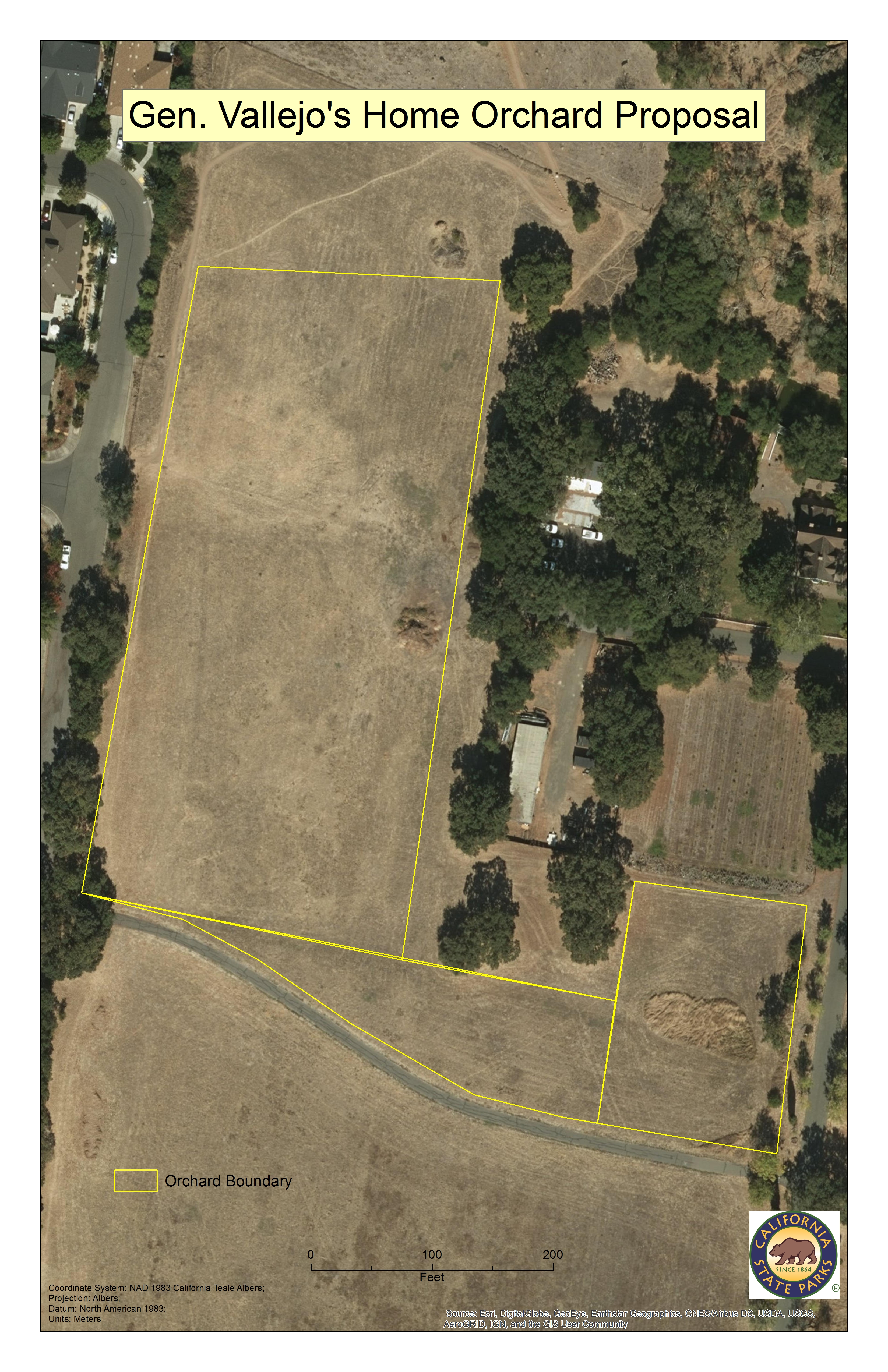
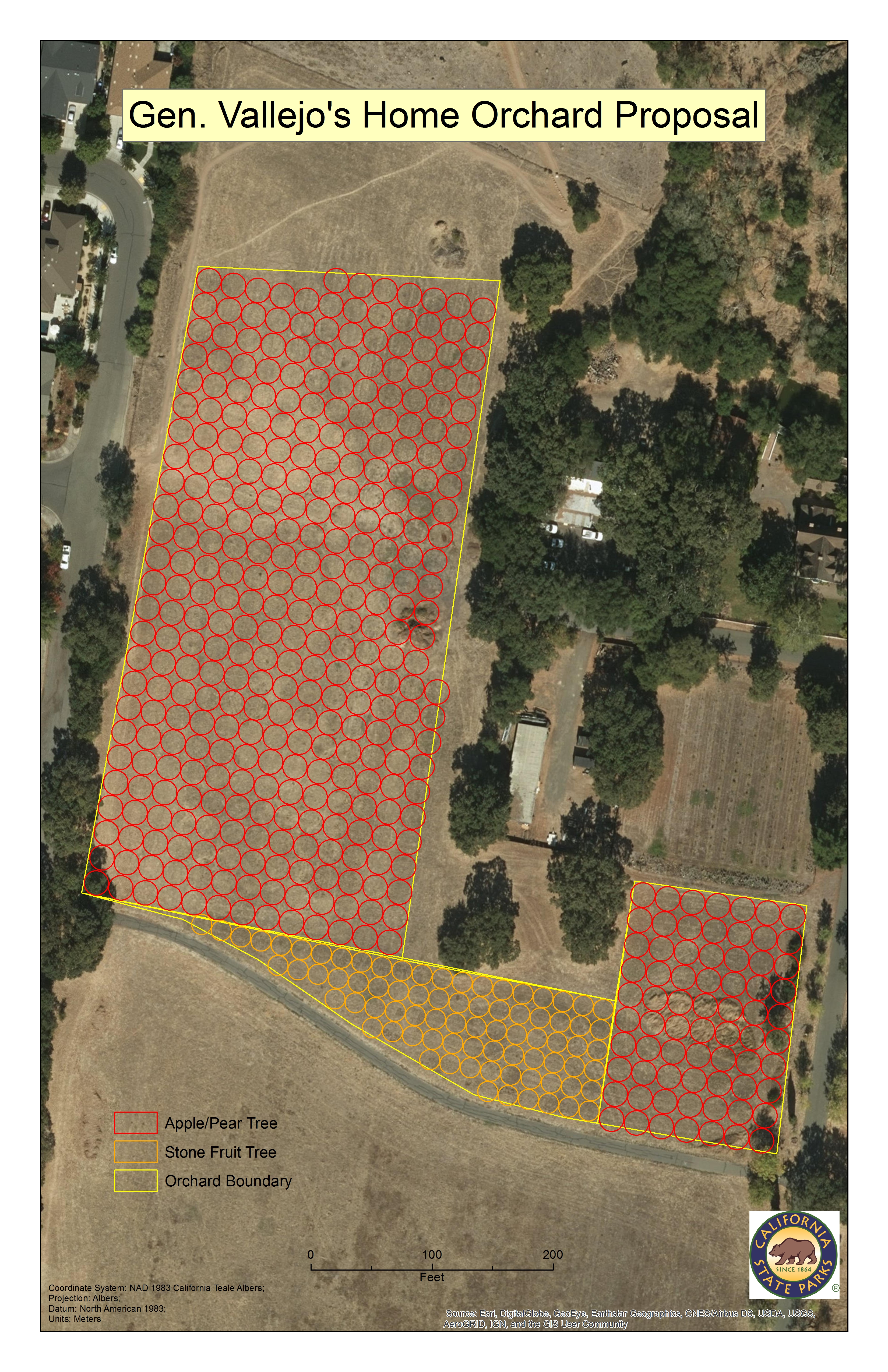
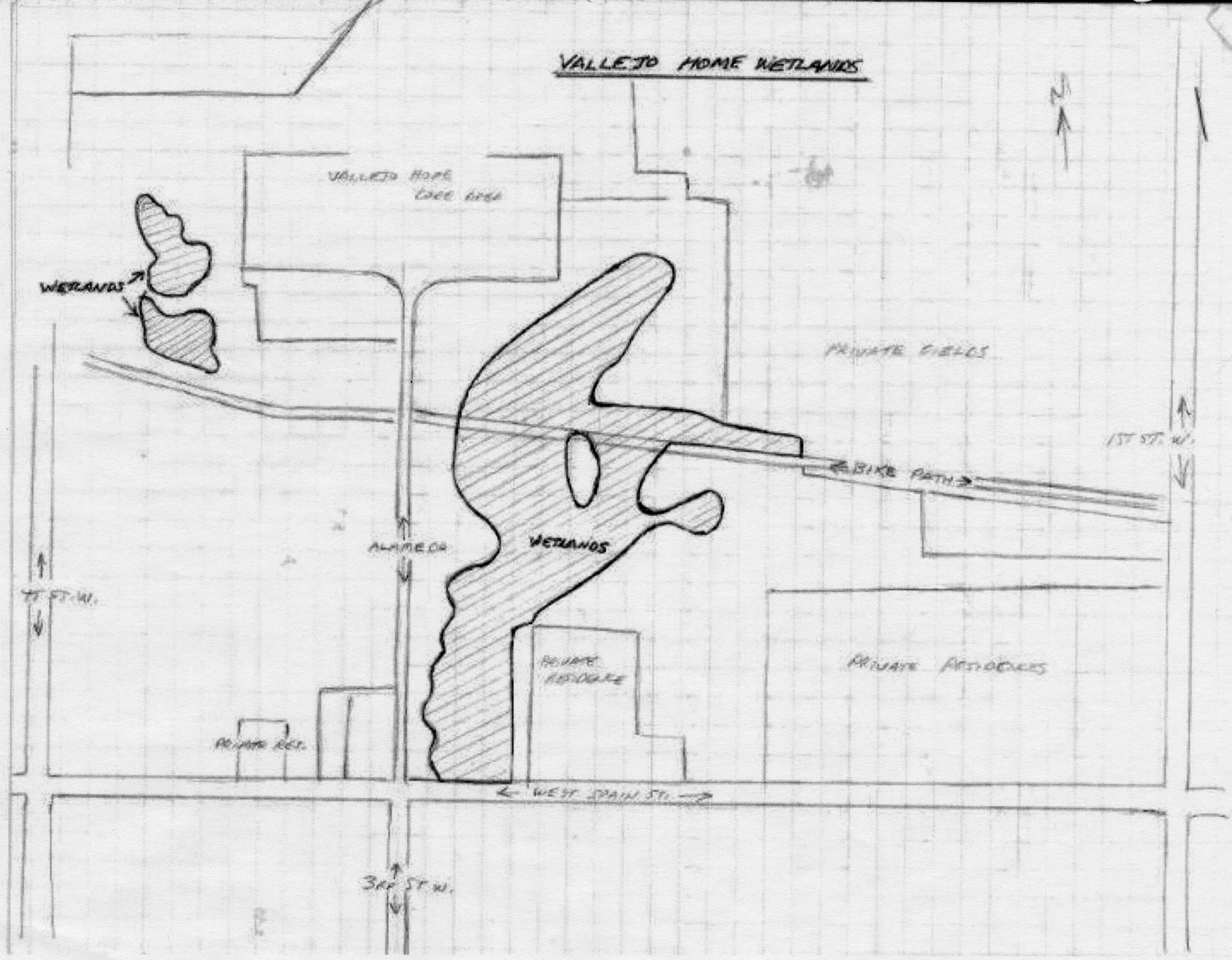
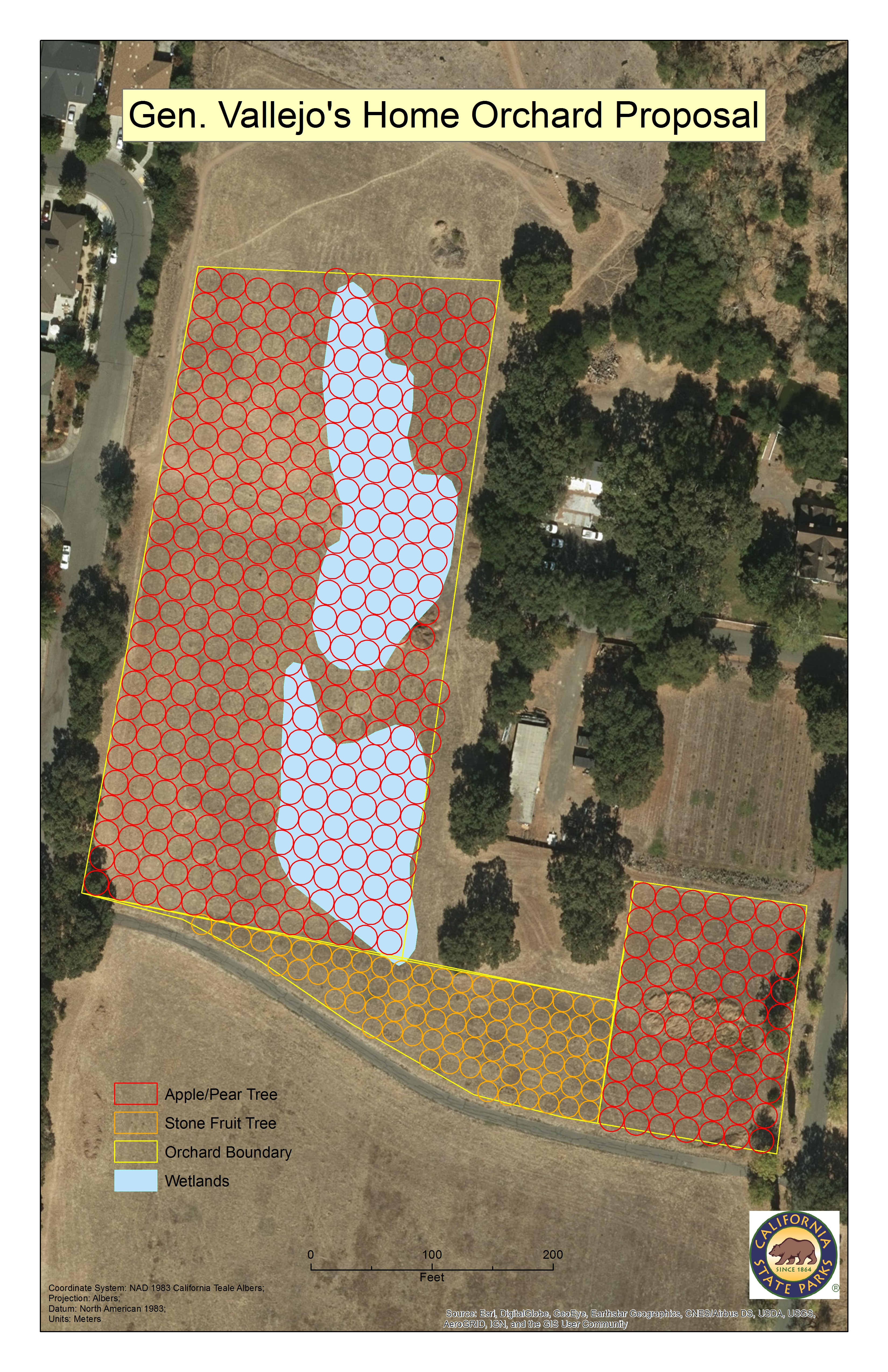
| Working with state historian Kathleen Kennedy (a historic orchard specialist), Kathleen had designated, on the recommendation of the parks personnel Lynn Lutz, an area for the planting of three orchards totaling about 4.5 acres. The two larger orchards will consist of apple or pear trees and the third will consist of some type of variety of stone fruit tree (cherry, peach, apricot et al.). Laying out a general boundary for the orchards, I populated each section with circles representing the two different types of trees. A red circle being 20 feet in diameter are the apple/pear trees and an orange circle being 16 feet in diameter are the stone fruit trees. I placed as many ‘trees’ in each section with no space in between in order to maximize all available space. There is some overhang along the borders, but no more than 30% in a few spots. But, there’s a hitch: two wetlands have been identified in the area proposed for the largest orchard. Wetlands are a protected habitat and State Parks is looking for special dispensation from the Army Corp of Engineers to waive any restrictions to re-plant the orchard (both wetlands have been disrupted by the construction and farming of the estate 160+ years ago). I added a layer for the wetlands based on an area map drawn by Lynn Lutz. I georeferenced the drawing and then drew polygons to clearly represent the two wetlands areas. |
|
|
Results | |
| All in all, in the 4.5 acres planned there can be a maximum 388 apple trees (318 in the large area and 70 in the small area) and maximum of 79 stone fruit trees in the third area (that is with no room spared in between each tree canopy). The wetlands, if they have to be taken into account, will affect (probably eliminate) 123 apple/pear trees and 2 stone fruit trees. |
 |
|
Analysis Albeit, the contents of the orchards are still a matter for speculation, the GIS presented here allows the historians, maintenance workers and other field people to re-establish the orchard according to historical records. For as many trees that can be planted, there probably should be a some space in between each tree, thereby reducing the number of trees. Currently, the wetlands are the only unknown factor. | |
|
Conclusions The orchard can be replanted according to the recommendations of the report and with this GIS as a guide to help and there are people looking to push this project forward, but there are some stumbling blocks. The State of California is very slow, most government agencies are, but CA State Parks is slower than molasses in winter on Pluto. Also, CA State Parks tends to be undefunded, very underfunded, so priority tends to be given to those the most desperate in need (or those with the most influence). The wetlands can potentially scuttle the entire project if no special dispensation is given for re-planting the orchard. Can the state parks acquire a waiver to plant in the wetlands area or will they have to plant around it or shift it entirely? Only the gods on high know. | |
|
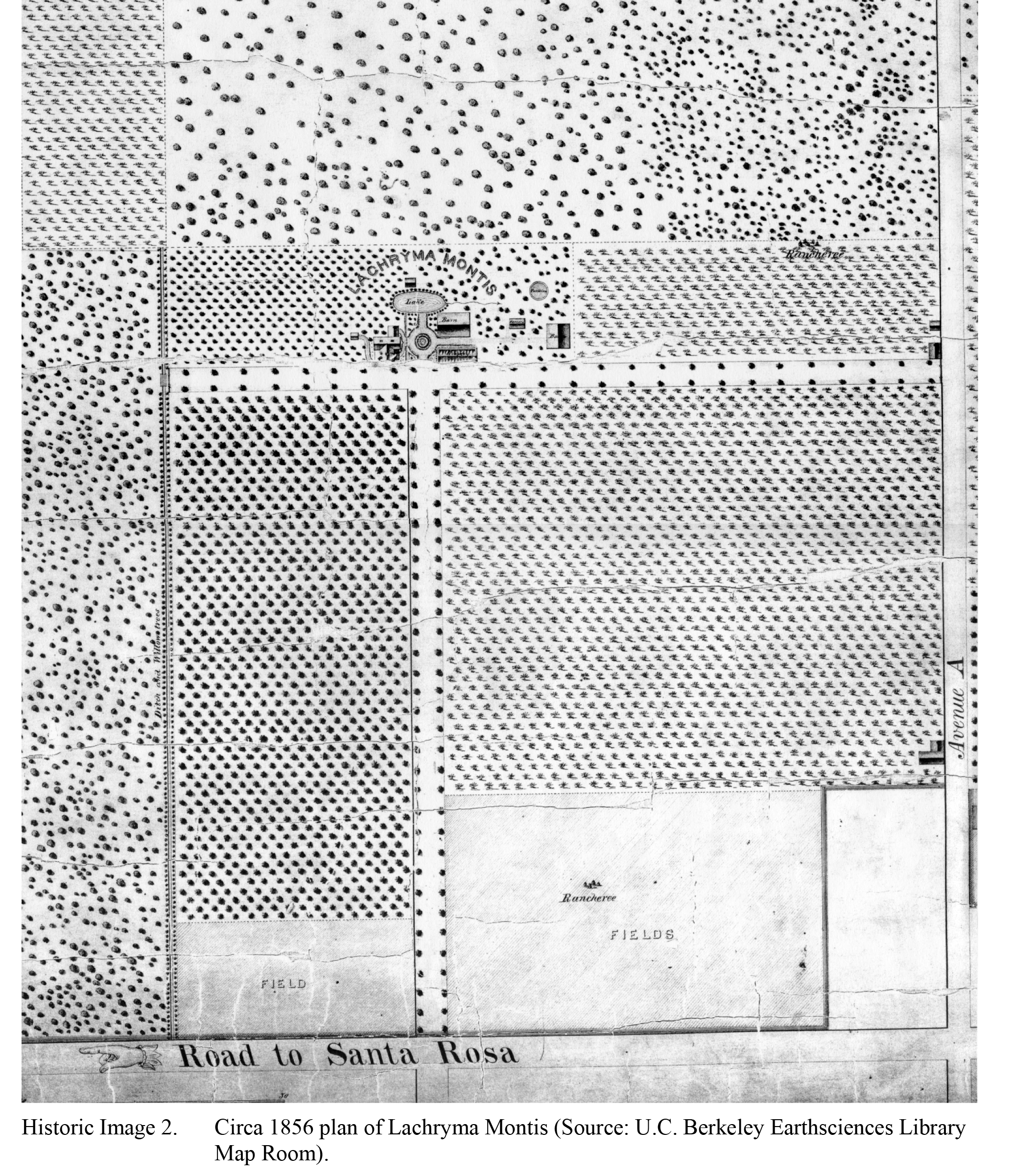
References 1. Bradley, D., Corbett, R. "Part 1 Cultural Landscape Report Lachryma Montis (General Vallejo Home) Sonoma State Historic Park." California Department of Parks and Recreation. August 2007. Accessed 24 Oct 2018. pg. 43-44. 2. Wikipedia Vallejo Estate 3. Wikipedia Mariano Guadalupe Vallejo 4. First Image - Copy available in the University of California, Berkeley, Earth Sciences Library, Map Room (Call No. G1528.S85; .T4 1877b; \f\). 5. Second Image - 1856 Plan of the villa and grounds of Lachryma Montis . . . County of Sonoma, Cal.: property of Gen. M.G. Vallejo, 1856. Available in the Bancroft Library (Call No. G4364.S794 1856; .P5; Case XD). | |