| Title Out with NAD 83, In with NATRF2022 | |
|
Author Kevin Herman American River College, Data Acquisition in GIS; Fall 2018 Contact Information: kevinherman14@gmail.com | |
|
Abstract TThe National Geodetic Survey is in the process of releasing a new horizontal datum known as North American Terrestrial Reference Frame 2022 (NATRF2022). The new reference datum is a result of widespread use of Global Navigation Satellite System (GNSS) and an aging physical infrastructure of survey points in which the North American Datum 83 (NAD83) is based upon. As a tectonically active area, California will be more affected than most other parts of the United States. This project provides measures to prepare for NATRF2022 and describes the extensive datum monitoring taking place in the state. This monitoring will provide California with dynamic reference points once the new datum becomes effective in 2022. | |
|
Introduction Advancements in Global Navigation Satellite Systems (GNSS) have allowed for more accurate positions to be made then were previously available. Even more accurate positions will be calculated and made with the implementation of new datums by the National Oceanic and Atmospheric Administration (NOAA). The new datum to be used in North America will be the North American Terrestrial Reference Frame 2022 or NATRF2022 for short. This reference datum will rely upon electronic GNSS reference stations and account for geologic plate movement. Spatial data created or maintained in reference to North American Datum of 1983 (NAD83) will need to be transformed. This project displays the extent of real time NATRF2022 data collection stations throughout California and how to prevent spatial data error in the future. | |
|
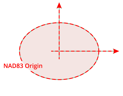
Background The North American Datum of 1983, was established using physical surveying techniques and with the installation of permanent survey marks. Since inception in 1983, these survey markers have been physically removed or damaged causing continual maintenance of the markers. These survey markers also move with respect to tectonic plate movement and have created a “moving target” datum. Although plate movement is on the magnitude of centimeters, the movement still effects the reference datum. Further refinement or "realizations" of NAD83 have shown the central reference point to be off by 2.2 meters, graphic shown below. (National Gedetic Survey, 2010). |
|
|
|
Methods | |
| To replace the physical landmarks, the National Geodetic Survey (NGS) at NOAA is utilizing Continuously Operating Reference Stations (CORS) to provide geodetic control of NATRF2022. The new reference frame is designed to be both static and dynamic, meaning spatial data can be referenced to specific time or to specific span (epoch) of time. Continuous CORS station data and locations are made available to the public on the NGS website. Transformations from previous datums to NATRF2022 will be made available to the public, but are not available at this time. |

|
|
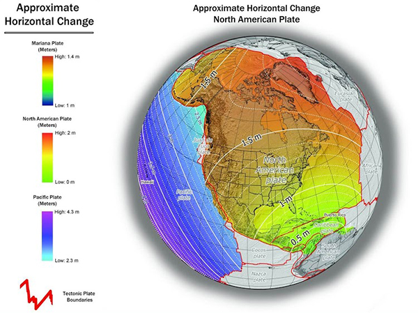
Results Geologically, California is comprised of the Pacific and North American tectonic plates with an active transform San Andreas fault dividing them. Consequently, long term geodetic control is difficult to attain and should be continually monitored. Geodetic control will be achieved in California the already installed CORS stations throughout the state. The figure to the right displays the vast number of CORS sites within California. A larger concentration of stations is located along the San Andreas fault, which is on the western edge of California. This western concentrations of stations allows for further refinement of the constantly moving plates below. However, as was shown previously, horizontal change is not equal throughout California. When performing transformations in the future in reference to NATRF2022, be cognizant that change will be difference throughout the state. | |
|
Analysis To prepare for this geodetic paradigm shift, it is recommended by NGS to use the NAD83 (2011), epoch 2010. This datum is in reference to NAD83, but further refinements were made in 2010 to make it more accurate. Usage of NAD83 (2011) will make transformations to NATRF2022 easier in the future. NGS currently provides transformations of spatial data and transformations into NATRF2022 will be made available as the year 2022 comes closer. Spatial data in reference to NATRF2022 will have the option to be dynamically referenced to a specific time or be statically tied back to snapshot in time. This is an important distinction between NAD83, which was static in nature. | |
|
Conclusions The new NATRF2022 will modernize geodetic controls away from terrestrial makers and align with modern technology. To prepare, geographic professional are encouraged to utilize current datums and most current realizations. Usage of the most current NAD83 (2011) will provide less data errors when transforming data to NATRM2022. Documentation of METADATA is key to understanding what reference frame existing data originated and how to transform the data to a future data frame. | |
|
References Literature cited. National Geodetic Survey. Improving the National Spatial Reference System . National Oceanic and Atmospheric Administration | |