Shady Oaks Disc Golf Course:
The Development of a Web Map Application
Author
Paul Oviatt
American River College, Geography 350: Data Acquisition in GIS; Fall 2018
Abstract
Disc golf is a sport that has been around in very simple forms since the early 20th century but didn’t get mainstream access and attention until the mid-1970’s with the creation of the Disc Golf Association (1976). A personal love and passion for the sport prompted me to use this opportunity to create a Web Application built on personally acquired data to give players another tool to enhance and enrich their playing experience. The application of GIS tools in conjunction with the sport of disc golf resulted in the successful creation of a Web Application that provides players tools for geo-measuring features, querying and filtering features, update and edit features, and share the app with friends on social media. Further improvements in the future could be made to include accurate out-of-bounds information. Lots of fun with this project.
Introduction
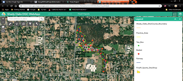
The goal of this project was to develop a Web App to be used with one of my two favorite hobbies, either snowboarding or disc golf. With both being outdoors the application of GIS seemed a natural fit. In the end I settled on developing the Web App for use with disc golf at one of my favorite local courses, Shady Oaks, located in Orangevale, California. I wanted to create an app which players could use and update in real-time to find tee box, basket locations, and have digital tools to enhance their playing experience during recreational and tournament play.
Background
The origins of disc golf can be traced back to the early 20th century, but “disc” golf as it is known today was coined by “Steady” Ed Headrick, who in 1976 established the Disc Golf Association (DGA) to form a new international sport and help promote and grow the sport that is so dear to my heart (Disc Golf Association, 2018). Prior to this the game was played by devoted fans of the popular Frisbee, copyright owned by Wham-O, throwing at “golf holes” that were usually drinking fountains, fire hydrants, garbage cans, and the rules were made up on the spot (Disc Golf Association, 2018). It reached a point that freestylers needed a permanent place to practice and showcase their skills and Headrick paved the path for them and through his diligent hard work with the Los Angeles Park and Recreation Department and Mary Becker he helped design and construct the world’s first Disc Golf Course at Oak Grove Park, Pasadena, CA (Disc Golf Association, 2018). I was first introduced to the sport in 2008 while living in Grass Valley, California and my passion and love for the sport has grown exponentially. I moved to Sacramento in 2012 and first played Shady Oaks Disc Golf Course, Orangevale, CA during that year. I now consider this to be my home course and have played it countless times. My early research into my project revealed that nothing like a Web App has been done for this course, so I was excited at the opportunity to break new ground in the evolution of the game.
Methods
This was new territory, so I developed my own data. To do this, first I started by creating feature classes in ArcGIS Pro that I would need to represent the disc golf course: pro-shop, tee box, basket, fairway, practice area, and course boundary. The attribute domain in the tee_box layer was made to allow for a choice of hole number and the basket layer for basket and hole location. Before sharing these layers on the Web they were configured to allow users to add, delete, and update them--these layers were shared with ArcGIS as Web Services.


The layers were then added to a Web Map and allowed to be editable and allowing for attachments.

To develop my data I had to acquire it by using the Collector Application by Esri, which I downloaded from the Google Play Store. Once I had the app I logged into my Esri account and opened the Web Map--from this point it was out to the course to start collecting waypoints.


For each of my layers I collected waypoints using the Add (+) button located on the toolbar of the app. I found the Collector App to be very accurate to my location and it made it easy to choose a layer, add a waypoint, switch to my camera for a photo, back to the app to add the attachment, and back to the game for more play and more collecting of data/waypoints.


Results
The data gathered from the Collector App went directly into the Web Map georeferencing the features in the layers and creating the Web App was initiated by launching the option listed under the Web Map itself. I chose a Theme to work with and made my choices for the widgets based on recommendations and my own personal choices which I felt applied or may serve useful.
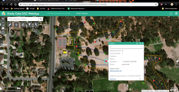
I allowed and configured pop-up’s so that by pointing and clicking on an item it would give attribute information and allow to view attachments.
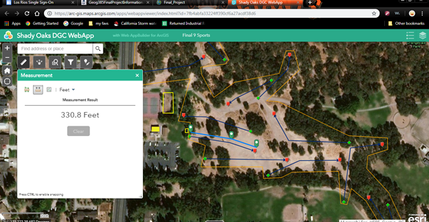
The Measurement widget was chosen for it’s obvious usefulness in relation to disc golf. It’s the USA, so it was set to Feet not Meters.
The Share Widget was chosen because of the social nature of disc golf and to further one of the Web App’s purposes as a medium to share information with other players. No configurations were made to the widget.

The Query Widget comes recommended and is useful in many situations, including disc golf, so it was added to the application. The tee_box, basket, and fairway were added as a (+)New Query with no other configurations.

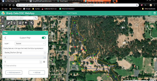
The Filter Widget was added for similar reasons. It was configured so that features could be eliminated from the users view (e.g. the tee_box could be taken off the screen by switching the icon from on to off) or a custom filter feature was added allowing users to filter for specific information by completing an expression.
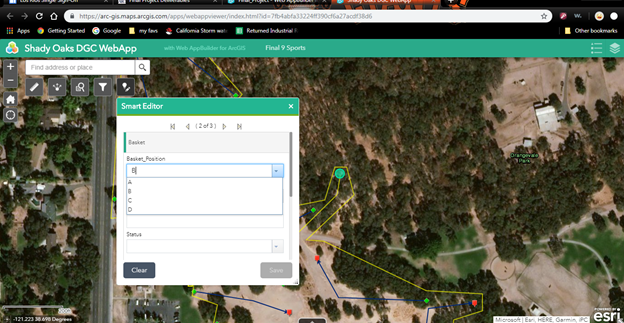
The Smart Editor Widget was selected because I intended for this app to be modifiable and kept as relavent as possible to allow for real-time additions and updates to keep players well informed. This allows for players that the app is shared with to update the various layers without having to use the Collector App.
Analysis
There were few problems to discuss with this project, which was a welcomed outcome. The one minor problem I did encounter was at first not being able to see every layer in the Collector App. I wasn’t able to see the Practice_Area layer upon first visiting the course even though I believed that I had created it in the same fashion as the other Line Feature Classes that I had created in ArcGIS Pro, which I had visibility on. I concluded that when I created that layer I had neglected to allow for the layer to be open to adding, deleting, and updating before sharing it to the web. I went back into ArcGIS Pro and Overwrote the Layer on the Web with that option selected and it cleared that obsticle up in the Collector App.
Conclusion
Future improvements to the Wep App would include Out of Bounds information within the course and hole boundaries, which was considered, but not all of these areas are clearly marked or the signs have been eroded by weather, so ultimately they were left off the map until accurate information on these areas could be acquired. Once this information has been obtained it would require me to create another feature class in ArcGIS Pro and Share it as a Layer to the Web. Then I would need to add the layer to the Web Map and the Web App would automatically be updated to reflect the change in features, after which players could update the information with the Smart Editor Widget. I think it should go without saying that I had fun while completing this assignment! I came away from this assignment feeling a lot more comfortable with ArcGIS Pro and certainly with working on Web Maps and Apps on ArcGIS Online. Good stuff!
References
Disc Golf Association. (2018, December 5). Disc Golf History. Retrieved November 1, 2018, from Disc Golf Association: https://www.discgolf.com/disc-golf-education-development/disc-golf-history/
Esri. (2018, November 1). ArcGIS Online. Retrieved November 1, 2018
Esri. (2018, November 1). ArcGIS Pro. Redlands, CA.
Esri. (2018, November 1). Collector for ArcGIS. Redlands, CA.
Final9 Sports Pro Shop. (2018, November 1). Final9 Sports Pro Shop. Retrieved November 1, 2018