| Title Avocado Site Suitability Analysis for San Luis Obispo County, California | ||
|
Author Karri Peters American River College, Geography 350: Data Acquisition in GIS; Fall 2018 | ||
|
Abstract California is the leading state for avocado production in the United States. With the introduction of invasive pests, as well as competition from foreign markets, there has been concern with keeping the avocado market in California healthy and lucrative (UC Coop, 2013). Of the six largest avocado producing counties in the state, San Luis Obispo County (SLO County) was picked for this study because it maintains the smallest acreage and has potential for market growth. To determine where new avocado production would be successful in SLOC, a site suitability analysis was performed in ArcMap 10.6.1 using information from avocado fields in production in 2016. Basic growing criteria ranges were extracted from the 2016 crop fields for land use, soil composition, slope, aspect, precipitation (30-year average), minimum temperature (30-year average), and maximum temperature (30-year average). Using the extracted range values, the criteria layers were reclassified to represent either suitable or non-suitable land. A fuzzy overlay with each reclassified criteria layer was performed, creating a binary raster that indicated where land in SLO County would successfully support new avocado production. The output binary raster indicated that 405,322.16 acres, 19.08% of land in SLO County, is suitable for new avocado production. The large percentage of land defined as suitable is likely dues to the simplicity of the analysis and the quality of the input data. While this output provides a good resource to start searching for new avocado production land, a more detailed analysis could help narrow down search options. | ||
|
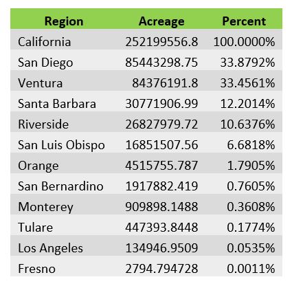
Introduction San Luis Obispo County hosts 6.68% of the total avocado producing acreage in California. By comparison, San Diego County maintains 33.88% of the acreage in California, affording it a competitive market advantage (See table bellow). To compete with larger counties, and help increase California’s overall avocado production, farmers could expand production into new areas of SLO County. To increase the likelihood of successful crop performance, agricultural land could be narrowed down to the areas that are the most conducive to avocado growth. By analyzing the conditions in which current avocado production takes place, the search for suitable production land could be narrowed down to those areas with similar characteristics. A simple site suitability analysis will evaluate land for the potential of successful new crop production, making the search for new suitable farming land more efficient. | ||
|
Background According to the California Avocado Commission, California is “home to about 90% of the nation’s crop” (CAC, n.d.). However, due to California’s variable landscape and climate, the majority of avocado’s consumed in the US come from other countries such as Mexico and Chile. While researchers are searching for ways to keep avocado production in California going year-round, and in new places such as the central valley, there was not much research into expanding production within counties already known for producing avocados (Romero, 2017). | ||
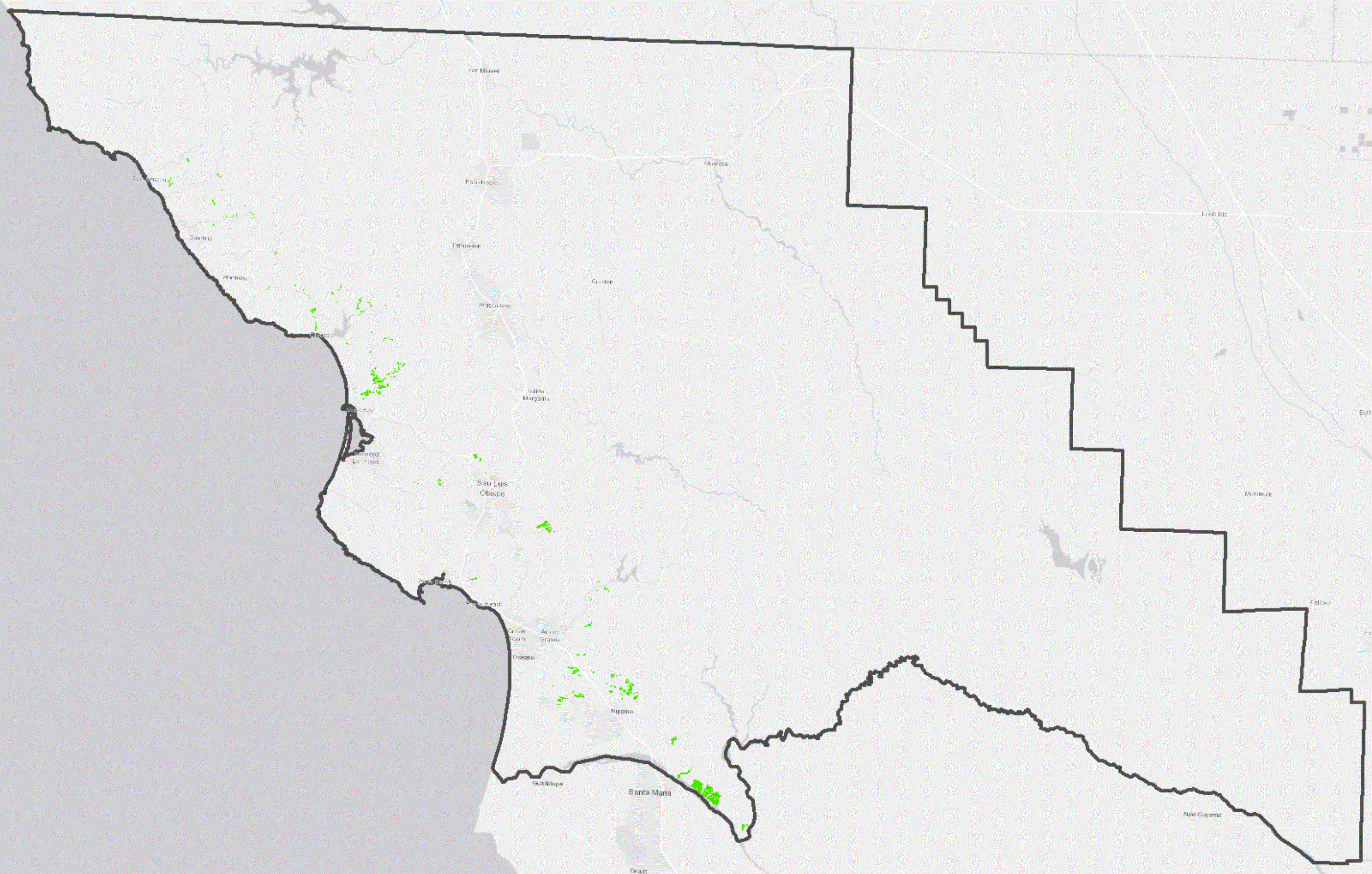
| Data Layers and Sources - The 2016 avocado field boundary layer (picutred right) and DEM were sourced from workplace proprietary data. The SLO County boundary and land use layers were downloaded from the County of San Luis Obispo Open Data Portal Website (http://opendata.slocounty.ca.gov/) The precipitation and temperature data were obtained from the PRISM Climate group website (http://www.prism.oregonstate.edu/normals/). The soil composition data was downloaded from the USDA Natural Resource Conservation Service SSURGO downloader application (http://www.arcgis.com/home/item.html?id=cdc49bd63ea54dd2977f3f2853e07fff). |
| |
|
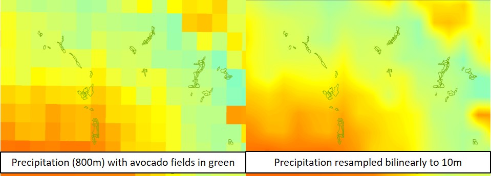
Methods Data Acquisition and Preparation - Data layers for each growing criterion were obtained from various resources and brought into an ArcMap document where they were clipped to the SLO County boundary and prepared for analysis. Aspect and slope were derived from a 10m resolution digital elevation model (DEM) using the spatial analysis extension. Precipitation and temperature data were resampled bilinearly to the resolution of the DEM in order to maintain consistency during overlay analysis and to accommodate avocado fields with smaller acreage (Figures below). For ease of analysis, the soil composition layer was simplified by performing a dissolve on the boundaries between unit types with the same major composition name. The soil composition and land use polygon layers were then converted to rasters, using the feature to raster tool, with the same resolution as the DEM. Defining Criteria Range Values - To get a preliminary idea of the percentage of avocados growing within each land use category, an intersect was performed on the land use polygon layer and the current avocado acreage layer. Avocado production was present in all categories of land use, with 1.19% located in areas designated as urban or multi-use public (Table 1). Due to the small acreage of avocados grown in these land use categories, and the assumption that new production would be difficult to initiate due to permitting requirements, they were considered unsuitable for new avocado production during overlay analysis. Next, the zonal statistics to table tool was run for each raster criteria layer, with the current avocado polygons used to define zones. The range for suitable growing conditions was determined by finding the minimum and maximum values for the aspect, slope, precipitation, and temperature (Table 2). To define suitable soil composition types an extract by mask was performed on the soil composition raster using the current avocado acreage as a mask. Performing Site Suitability Analysis - Using the derived growing criteria, binary rasters were created for each layer in which a value of 1 represented a cell with suitable growing conditions, and a value of 0 was considered unsuitable. Conditional evaluation using the raster calculator was performed to create the binary rasters for slope, aspect, precipitation, maximum temperature, and minimum temperature. Below is an example of the conditional evaluation used in the raster calculator to produce a binary raster with a value of 1 for slopes between 0.005185° and 38.1095°, and 0 for all cells that do not fall within this suitability range: Con((("%SLO_Slope%" < 38.1095) & ("%SLO_Slope%" > 0.005185)), 1, 0) Land use and soil composition binary rasters were created using the reclassify tool. The land use raster was reclassified according to the preliminary results of the intersect performed when defining criteria values by excluding urban and multi-use public lands as suitable for production. In order to create the soil composition binary raster, the attribute table from the extract by mask layer was consulted when entering values of 1 or 0 into the reclassify tool window. A current avocado acreage raster was created, by using the feature to raster tool, then reclassified so that existing avocado acreage had a value of 0, and everything else had a value of 1. This was done so the existing acreage would be excluded during overlay analysis, resulting in a raster displaying only the land that has potential for new avocado production. A fuzzy overlay of all binary rasters was performed to get a raster in which suitable land for future avocado production maintains a value of 1, and unsuitable land has a value of 0. |
|
|
| ||
|
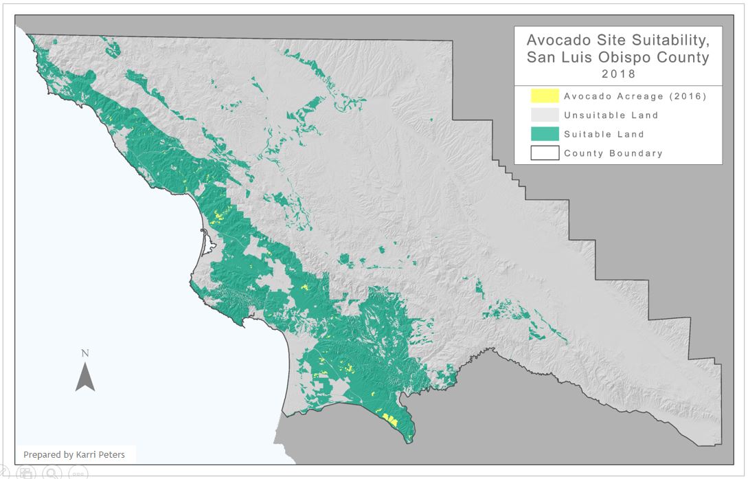
Results The area of land suitable for new avocado production is 405,322.16 acres, accounting for 19.08% of the total area of San Luis Obispo County. | ||
|
Figures and Maps | ||
 |
 | |
|
Analysis The results of this analysis identified a large percentage of land within San Luis Obispo County as suitable for new avocado production. The large area is due to the wide ranges in values derived from the criteria layers in areas of current avocado production. These value ranges could be narrowed in future studies if the current avocado fields were classified by productivity, with only the most prolific fields included in analysis. If more detailed data was input into this analysis, such as localized climate data with higher resolution, it its likely the current avocado production ranges would be more refined. Many factors that contribute to the suitability of land for new avocado production were not included in this basic analysis for the sake of time and simplicity. In a more detailed study, other criteria layers would be analyzed, in conjunction with existing criteria, including but not limited to the availability of land for purchase, proximity of irrigation resources, proximity to shipping routes, and endangered species habitat. To perform a more precise analysis, an expert in avocado growing conditions could be consulted to help assess the relative importance of each growing criteria. The layers would then be ranked and weighed during overlay, with the output consisting of a map with multiple ranges of suitability. | ||
|
Conclusions This study achieved its goal, to define land in San Luis Obispo County as suitable or non-suitable for new avocado production. While the results produced a large area of land considered as suitable, this output would be useful in narrowing the search for new farm land. | ||
|
References Avocado Production in California, Second Edition. The UC Cooperative Extension, San Diego County and The California Avocado Society. 2013. Accessed on October 1st, 2018. Available: https://ucanr.edu/sites/alternativefruits/files/166823.pdf Bradsher, Keith, January 27th, 2017. To Understand a Tax on Mexican Imports, Consider the Avocado. The New York Times. Access on October 1st, 2018. Available: https://www.nytimes.com/2017/01/27/business/economy/importers-tax-mexico.html California Avocado Commission, No Date. The History of California Avocados. Accessed on October 1st, 2018. Available: https://www.californiaavocado.com/avocado101/the-california-difference/avocado-history Romero, E. D., April 27, 2017. California Is On Its Way To Having An Avocado Crop Year-Round. National Public Radio. Accessed on October 1st, 2018. Available: https://www.npr.org/sections/thesalt/2017/04/27/525737123/california-is-on-its-way-to-having-an-avocado-crop-year-round | ||