Abstract
By federal mandate, the State of California must develop a comprehensive assessment of the state's public drinking water sources. This assessment will include the mapping of about 16,000 water sources. Presently no consolidated database exists of the states public drinking water sources. For the coordinate information that does exist, there is little information to attest to its accuracy. The California Department of Health Services (CDHS), the organization responsible for to perform the survey, will collect new coordinate information for each source using GPS. GPS is a quick and easy means to collect the coordinate data which will be standardized in format providing for efficient and effective database access. To gain a level of confidence of the relative accuracy of the data that will be obtained from GPS, a test of four well sites was conducted. Maps created were layered with existing database coordinates, uncorrected GPS coordinates, and differentially corrected GPS coordinates for each of the four sites. This data was placed on a geo-referenced, digitally scanned, ortho-rectified, mosaic air photo which showed the actual location of each well. The results of the test clearly show that the differentially corrected GPS data was within two meters of the actual location where the collection was made for each well. It also proved to be more accurate than existingdatabase coordinates. Worst case using differentially corrected GPS data, coordinates will be within 2-5 meters 95% of the time. Lessons learned from this test will help insure that data collected will be standardized between collectors and collection problems will be kept to a minimum.
Introduction
Accurate coordinate data of the state's public water sources is an essential aspect of the data being collected by the CDHS. Presently, there is no standard applied to documenting the location of over 16,000 public drinking water sources in the State of California. Some are located by street address, some by latitude/longitude, while others may be located by a point on a map as a best guess of its location. Other water source data to be collected by the CDHS include source substrata and potential contamination sources in a given radius. Having an accurate location of a source is critical in the determination of potential contamination sources. GPS is now recognized as a source of reliable coordinate data. A test of four well sites was used to determine if the GPS would provide an acceptable accuracy for the report and a standardized product. Four ground wells were selected that had coordinate information available from an established database. The GPS would be used to collect data to compare against the established data, using an orthorectified air photo of the area as a means of comparing the "absolute" location of the wells to locational data. The UC Davis Information Center for the Environment (ICE) has been contracted to provide GPS support and has developed a data dictionary for well metadata. To help visualize and gain a clearer understanding of the relationship between the coordinate information, the well coordinate points were plotted on an ortho-rectified air photo. The map demonstrate the relative accuracies of the data.
Background
The CDHS has published a document (Drinking Water Source Assessment and Protection (DWSAP) Program , January 1999) to address federal mandate to provide a comprehensive assessment of the state's public drinking water sources. This document establishes the bounds of the program, the data to be collected/created, and the time frame for accomplishment of the task. In preparation of the collection of data, a tack force has been created to set up collection procedures and standards. The use of GPS will be central to the collection of well source coordinate data for the 16,000 well in the state. A demonstration of the value of GPS in collecting coordinate data and draft collection procedures/ guidelines was required as initial part of the data collection phase for this project.
Methods
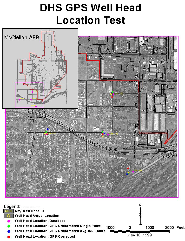
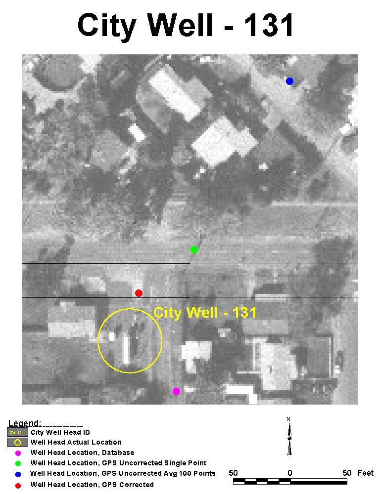
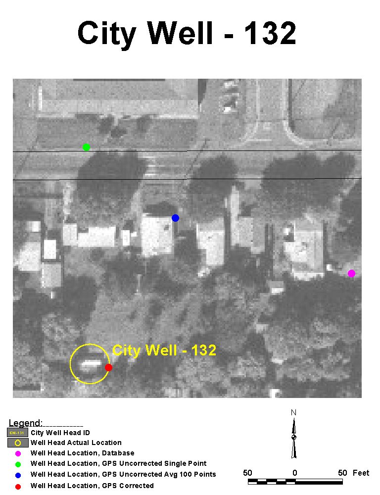
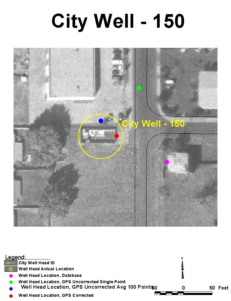
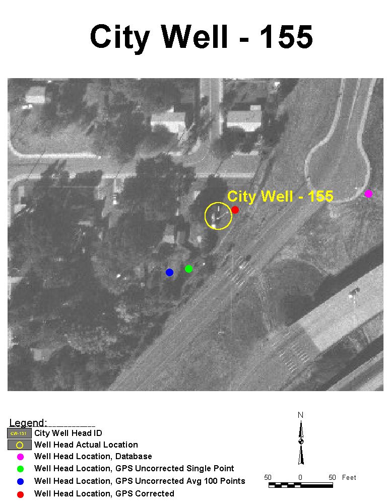
Four Sacramento City ground wells were selected for this study. The wells selected had coordinate data available through a well monitoring database being used by the USAF as McClellan AFB. The wells are all in proximity of each other, and within an ortho-rectified air photo of McClellan AFB. The resolution of the photo is about 1.8 feet per pixel, taken October of 1997. The four wells are visible on the map, providing a reliable reference to compare coordinate data against.
The GPS instrument used to collect the data was a Trimble GeoExplorer II, the same instrument that will be used by the CDHS. The data dictionary provided by ICE standardizes the GPS data collection for each site. Data to be collected includes well ID, collectors initials, and coordinates.
The uncorrected data accuracy of the GPS can be up to 100 meters 95% of the time, and greater than 100 meters 5% of the time. Differential correction of the data brings the accuracy to at least 2-5 meters 95% of the time.
Collection of the GPS data was accomplished during a single day. Due to the fencing surrounding each well, data collection was taken at the gate for each well. To avoid confusion and conflicting data, the GPS unit was standardized using the factory default options for instrument setup. The following parameters, critical for recording accurate GPS data, are preset in the factory default mode:
- Feature Logging Rate, Points: One-second interval.
- Feature Logging Rate, Line/Area: Five-second interval.
- Feature Logging Rate, Min Posn: 120.
- Not in Feature Rate: Record all positions calculated.
- Position Mode: 3D.
- 2D Altitude: No Entry.
- Elevation Mask: 15 degrees.
- SNR Mask: 5.
- PDOP Mask: 6.
- PDOP Switch: 6.
Use of these settings by the data collectors of the CDHS and other agencies collecting data will reduce data incompatibility and confusion.
The results of this test demonstrates the value of GPS in providing reliable coordinate data. Five maps were created using coordinate data obtained from an existing data source, air photo, and GPS
Each well is represented on the maps by a set of four points:
-The point represented by a small yellow circle, is the actual location of the well on the air photo. This is considered the "actual" location of the well. The photo NAD 27, California State Plane, Zone 2, photographed in 1997.
-The burgundy point is the location of the well from the McClellan AFB well database. Little metadata for this database is available. This data was obtained from a well log database, which included city well ID, and coordinates in NAD 27, California State Plane, Zone 2.
-The blue point represents the uncorrected GPS data.
-The orange point represents the differentially corrected GPS data.
Figure 1: This map provides an overall view of the general location of the well heads that were used in this study.
|