|
Monterey Bay Area Production-Consumption Region with 100-year Floodplain
Karen Garden
American River College
Geography 26: Data Acquisition in GIS, Spring 1999
Abstract
A Geographical Information System (GIS) was used to determine if Sand and Gravel mining occurs in the 100-year floodplains. The site that was chosen for this area is the Monterey-Bay area. With the GIS analysis, it was determined some areas would be inaccessible if major flooding occurred.
Introduction
Sand and gravel mining (called "aggregate") commonly occurs within 100-year floodplains as defined by the U.S. Army Corps of Engineers. A 100-year floodplain is mapped where hydrologists statistically expect a major flood to occur once every 100 years. Environmental and permitting agencies would much prefer mining operations be conducted outside of identified 100-year floodplains because these areas frequently contain sensitive riparian habitats and are major sources of fresh surface water and groundwater. Additionally, in recent years the California Department of Fish and Game initiated an extensive project to dramatically increase native salmon and trout spawning in active stream channels. In-stream mining operations, as well as some near-channel operations can seriously hamper the spawning ability of these fish by adding downstream clay and silt effluent.
Background
The California Division of Mines and Geology uses Mineral Resource Zones (MRZ) maps to delineate high-quality sand and gravel resources near urbanizing regions of the state. Currently, flood data maps exist by the Federal Emergency Management Agency (FEMA) and so do Mineral Resource Zone (MRZ) maps, but it is impossible to locate a map with a combination of the two. I propose to combine the data, which includes GIS information, and to compile a final presentation of both in map format. What is needed in this type of combined map is a scheme that would determine what part of aggregate resources within a study area would fall within the 100-year floodplain.
I propose to take data from the FEMA maps and extract the information I need to depict the 100-year floodplain. Once I have this information, I plan to overlay this data over my base maps. The Teale Data Center has scanned the topographic base maps I am using. Each of these Teale maps must be registered so the longitudes and latitudes are geographically registered in GIS format. I have also digitized the aggregate resource areas that are of importance to this study. Additionally, I created a database with information about the mines such as location, company name, ownerĺs name, aggregate resources, and additional information as needed. There are also several other layers that were used to prepare this base map.
One of my current projects includes an aggregate update report that presents information about construction aggregate resources in the Monterey Bay Region originally completed in 1983. This update report also conveys important information on the present aggregate resources in the Monterey Bay Region for the benefit of local lead agencies. Information provided in this update reevaluates the availability of aggregate resources.
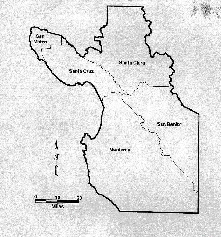 Map of Study Area Map of Study Area
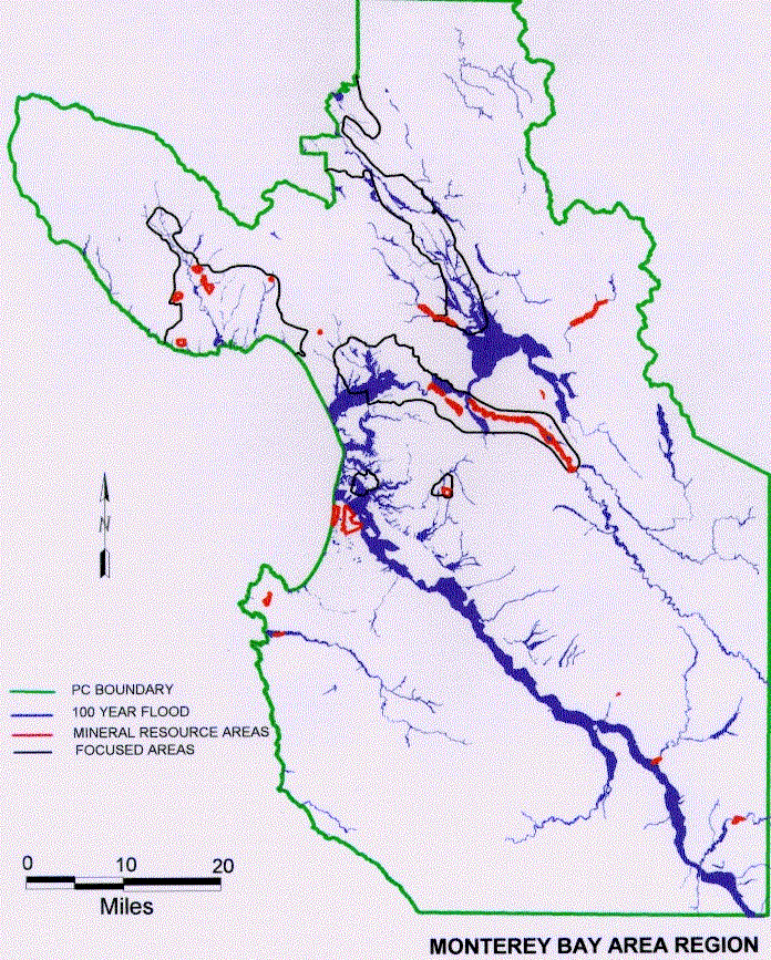 Combined map showing Mineral Resource Zones and Floodplains Combined map showing Mineral Resource Zones and Floodplains
Methods
The maps in this update report were created in several ways. The original 1983 maps (at a scale of 1:100,000) were originally on mylar which was cut and pasted together. After they were pasted into two maps, they were digitized and georeferenced. To see how accurate this would be, I then added a file that includes 7.5-minute quadrangle grid lines. These two maps were used to show the study region.
The maps that were used for the presentation went through several steps. To show the Mineral Resource Zones (MRZĺs), I used mylar maps from the previous 1983 version at a scale of 1:24,000. I had to build a file for each quadrangle with a database. At that time, I also had to set up the parameters such as the scale and projection. Once that was completed, all that had to be done was to go in georeference each corner. These maps had a projection of NAD 27 (Zone 10). Once I had registered the four corners of the 1:24,000 quadrangle, I then checked the error rate. If the error rate was at itĺs minimum, then the linework was digitized. If not, then I went back and re-registered approximately 8-12 points on the map after the linework had been digitized, all the pertinent information needed to be added in the tables. Some MRZ lines were added to the paper map by the geologist, which then had to be digitized. All of these steps were involved just for making the MRZ lines.
Topographical maps were received from Teale Data Center on CD. The topographical maps were raster images. Each of these had to be converted into MapInfo Format (MIF). To convert each of these, they also had to be registered and georeferenced. The maps from Teale Data Center were from a projection of Albers Equal Area. Once all of these were registered and saved as a MIF, then MapInfo could read the files with no problems.
The last portions to be added to these maps were the floodplain areas. This data was provided by FEMA. Again, these maps were controlled by using the 1:24,000 scale. This information came on a CD with an instruction binder. The data first had to be brought into MIF tables. Once these were brought into a file that MapInfo could read, then we had to figure out a way to separate the chance of a flood in 100 years from other flood data. This information was taken from the "Q3 Flood Data" by running some queries. Q3 flood data does not have any attributes; the data does not identify streams or rivers by name, but is shown by a series of map lines. There are just a lot of lines showing up on paper. These data were sorted into four counties. Once I had saved each of these data sets for each county into their own file names, I was able to bring up the Teale Data maps that I had previously registered. This enabled me to see the areas that would fall in a 100-year floodplain. Unfortunately, the "Q3 Flood Data" does not show important attributes such as hydrographic features, base flood elevations, roads, road names or any transportation data. This data cannot be assessed except through GIS software. It was necessary to bring in the data for these attributes from MapInfo.
A total of forty-five 7.5 minute maps were created by using a process involving the three databases defined above; (1) digitized original 1:24,000 scale maps, (2) georeferenced Teale Data topographic base maps, and (3) retrieved and processed FEMA database. Map 1 and 2 are done at a scale of 1:100,000 while all the others maps were depicted at a scale of 1:48,000. The study region could not have been created without the original 1:100,000 scale maps from 1983. The base maps could not have been produced without the Teale Data maps. These processes were compiled into the final product and will be available through the Division of Mines and Geology. These maps show the MRZĺs, floodplain areas, in-channel areas, and where the active aggregate mines are located.
Results and Discussion
This project took about 14 months to complete. One of the difficulties I experienced was the projection problem. I had three different projections that I had to take into consideration. One function of MapInfo is that the raster image projection overrides all the other projections. It essentially changes all the other line work to match with the raster image, which in this case was Albers Equal Area. Originally, when I first digitized the maps, I had some projection problems. The lines were off by several hundred feet. It was only by changing the projection to the correct projection that I was able to get the linework to line up accurately. From the beginning, this project was an experiment. We had never done a map showing both the floodplains and the MRZĺs. This was important to be able to combine the two so we could eliminate one whole set of maps. It makes it easier for everyone to see the complete picture without having to look at multiple maps.
Another major problem that was encountered was the digitizing. While digitizing large databases with complex linework, it is sometimes difficult to keep a high accuracy level. Digitizing linework at large scale needs to be smooth rather than sharp and edgy. Depending on what scale it is digitized at, the final product will show smoother lines when the data are digitized at larger scales. Originally, the maps were going to be digitized at a scale of 1:48,000, but we found that the lines were not accurate. Therefore, we digitized from a scale of 1:24,000. The final products were printed at a scale of 1:48,000. Another problem was deciding how to digitize these maps. Should we scan the maps and then do heads-up digitizing or do we digitized directly from the maps? We decided to digitize directly from the maps as we had more control over the accuracy. With a scanned image, it is a raster image and I felt it would lose some of its accuracy with folds in the paper and with the paper stretching.
Another major problem that was encountered was trying to use new software called "R2V." This is supposed to change a raster to a vector image. The biggest problem was there was too much background on the image so it showed up with lots of speckles. The R2V does have a despeckle function, but I was not able to get rid of all the little marks. The other problem with the R2V was that it sometimes added little lines to places where it thought it should go. One thing that was noticed with the R2V was that there were millions of nodes compared to what I had digitized. I did finally learn how to eliminate some of the nodes without affecting the shape. R2V is a good tool with the right type of raster image. I think with a little more time and practice, the R2V can be a useful tool in the future. As it was, R2V was not used in the final version of the project.
This project is not complete yet. The flood maps did not lay out on the maps correctly and need to be digitized directly on the topographical maps. I think the final project could be improved with some changes. One thing that needs to be looked at more carefully is how do we digitize this information. Is it more accurate by scanning the images and doing a heads-up digitizing, or is it better to digitize this directly from the digitizer tablet? One thing that needs to be carefully thought out is how to print these maps at different scales without having to change everything. Some people want these maps at 1:24,000 while others were satisfied with it at 1:48,000. One way I was able to surpass this problem was to make a duplicate set of these files and rename them with an "X" before them. I then was able to go into the layout window and recreate a map according to the new scale. Of course, that also meant all the labeling had to be redone as well as the thickness of the lines.
Conclusion
The validity of this project is very low. There are numerous errors in the data. One major error was found to be in the flood maps. FEMA does include a disclaimer with their disk. Their disclaimer states:
"The Q3 Flood Data contained on this CD-ROM can be a valuable tool to assist FEMA and the user community in floodplain management, hazards analysis, and risk assessment activities. However, the geographic processing and conversion used to produce the Q3 Flood Data may introduce differences from the original paper FIRMS; there, the Q3 Flood Data may introduce differences from the original paper FIRMs; therefore, the Q3 Flood Data product must be used with considerable care and judgement." I found by taking the paper maps by FEMA, and copying the lines directly on the 1:24,000 scale map, that there was quite a big difference compared to what the digital files showed. Due to time constraints, this part of the project was not completed.
The results of this project are not accurate enough to draw any hard conclusions. The results are valuable, however, in that it does provide mining information to the county planners and environmental and permitting agencies. This report, when completed, will be given to the county and lead agencies. Those lead agencies are required to review the data and establish mineral resource policies within their General Plans. When the study is completed, more precise flood data should be used and hand drawn to get more accurate results.
References
Federal Emergency Management Agency (FEMA), Q3 Flood Data
Dibblee, T.W., Jr., Nilsen, T.H., and Brabb, E.E., 1979, Preliminary geological Map of the San Juan Bautista 7.5 minute Quadrangle, San Benito and Monterey counties, California: U.S. Geological Survey, Open-File Report 79-375, scale 1:24,000.
Graham, Lee A., (1997). Modern-Day Magic., 10 (7), 32 - 38.
|