Title:
Rain gauge Collection Comparison
Author:
Shawn E. Perkins
Geography 26, GIS Data Acquisition, Spring 1999
American River College
Sacramento, California
Abstract:
The following report was to compare performance of manual and electronic rain gauges in the amount of precipitation that was collected in a dedicated time period.
Introduction:
In 1995 Pacific Gas & Electric (PGE) began changing their manual precipitation gauges (SRG) to a unit called ANoah II Total Precipitation Weighting Gauges@ (ETI.). Up to that time PGE had collected precipitation manually by gauges that have been in use for many years. The SRG gauges are based on a can and measuring stick. The new ETI gauges are based on weight measurement using a load cell. The electronics within the gauge converts the measured weight to water equivalent precipitation. PGE is concurrently still collecting precipitation manually at some sites. My goal is to compare the SRG gauges to the ETI gauges and to show if there are any differences in the amount collected in the same period of time.
Objective:
The author will be comparing a Eight inch manual AStandard Rain Gage@ (SRG) to a Electronic NOAH II Total Precipitation Gauge (ETI). The information about the SRG equipment was provided by National Weather Service (1), the ETI equipment information was provided by the Eti Instrument Systems INC. designer of the equipment (2)..
Data Source:
The manual data was collected by the PGE observers located at the sites and sent to the National Weather Service, Sacramento California. The Noah II electronic data was collected by the Department of Water Resources, California Data Exchange Center, located in Sacramento, California. Data was collected for three stations for seven months, two of those three stations the data was collected for one year. All of the station were located in California.
Methods:
In order to compare data it was necessary to locate stations that were currently using the ETI gauges and the SRG gauges. Out of the 24 PGE stations, I was able to get data for three stations. I choose these stations because, they were still using both methods of collection and the data was easily available. The information was collected on site location and mapped. The two stations with the one year history were Lake Spalding and Pit River #5. The station ABucks Creek@ had the Noah II information only available from October 1998. I did a comparison for the three station for the months from October 1998 to March 1999 and a comparison showing Lake Spalding and Pit River 5 from March 1998 to March 1999 and charted the results.
Instrumentation:
Picture 1: 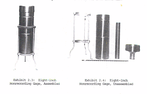
The Standard Rain Gauge (SRG) (Picture 1) has been in use since the 1800s. It is manufactured by different vendors, following the specs that NWS provides. The gauge is operated with 8 inch orifice on the average height of 3 feet above ground level. It has no moving parts, with a measuring resolution of 0.01 inch of precipitation. It permits collection of rain or snow. The National Weather Service has been using this equipment for over 100 years. It is manually collected, uses a standard eight inch can with a smaller diameter measuring tube inside the can. A funnel connects the eight inch can with the measuring tube. A measuring stick is used to measure the precipitation. The whole unit sits in a support bracket.
Picture 2: 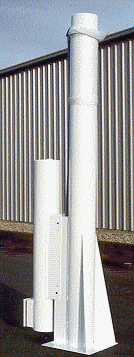
Noah II Total Precipitation Gauge (ETI) (Picture 2) is manufactured by ETi Instrument Systems Inc. The Department of Water Resources has been using this gauge since 1991. PGE started installing them in 1996. The gauge is operated with a 12-inch diameter orifice on the average height of 10-22 feet above ground level. It was supplied with a wind shield made of heavy-duty, fixed plastic panels.(1) The ETI NOAH II 8 and l2-foot Total Precipitation Gauges provides unattended measurement of large amounts of precipitation in the form of either rain or snow over the full range of temperatures and environmental conditions. Operates unattended for long periods of time and uses very little power, which can be provided by using a 12-volt DC power source (Solar Power).(1) The equipment weighs the Precipitation in the form of either rain or snow and is collected in the chamber and mixed with a charge of antifreeze to keep the contents from freezing. A thin film of evaporation-suppressant oil manually placed in the gauge retards evaporation of the solution. The weighing-type transducer measuring components deliver a resolution of 0.01 inch to 0.05, inch. depending on the specification of the buyer.
It permits collection of rain or snow and mixed with a charge of antifreeze to keep the contents from freezing. The drain-and-recharge feature automatically drains the gauge collection chamber when the level reaches a specific height. Once the chamber is emptied, a charge of specially formulated, environmentally friendly antifreeze solution is pumped into the collection chamber to keep the contents from freezing. As the accumulated precipitation increases, the gauge electronics produce a single pulse for each 0.01 inches of increase.(1)
Station Information:
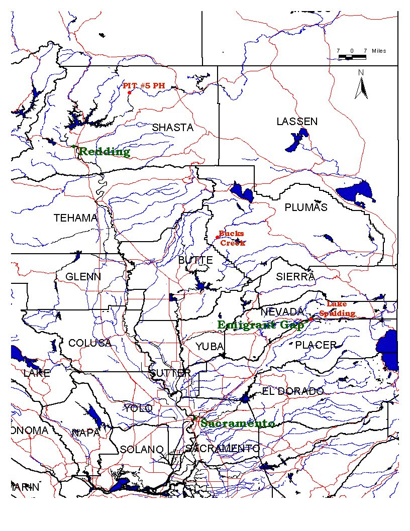
Table 1 shows the geography location of the sites. The latitude and longitude were derived by using a hand held GPS unit. The locations were measured at different times by each agencies.
Table 1:
|
|
Latitude |
Longitude |
Elevation |
|
Bucks Creek |
|
|
|
|
PGE |
39. 55' 12" |
-121. 19' 58.8" |
1760 ft |
|
NWS |
39. 55' |
-121. 33' 33" |
1760 ft |
|
|
|
|
|
|
Lake Spaulding |
|
|
|
|
PGE |
39. 19' 12" |
-120. 37' 58.8" |
5156 ft |
|
NWS |
39. 19' |
-120. 38' |
5156 ft |
|
|
|
|
|
|
Pit River #5 |
|
|
|
|
PGE |
40. 59' 13.2" |
-121. 58' 40.8" |
1458 ft |
|
NWS |
40. 59' 13' |
-121. 58' 38" |
1458 ft |
|
|
|
|
|
|
PGE = Pacific Gas & Electric |
|
|
|
NWS = National Weather Service |
|
|
The following map shows the locations of the stations. These stations are located in Shasta, Plumas and Nevada County, State of California.
Length of Record
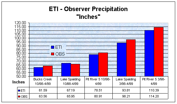
Two of three stations have a record for one year, the third station for only seven months (Table 2). The reason for this was the ETI was not installed until October 1998. Chart 1 shows the record for the period of one year with the two stations (Lake Spalding and Pit River # 5) and the seven month period with all three stations.
Table 2:
|
Length of Record |
|
Bucks Creek |
10/98-4/99 |
|
Lake Spalding |
10/98-4/99 |
|
Lake Spalding |
3/98 - 4/99 |
|
Pit River # 5 |
10/980-4/99 |
|
Pit River # 5 |
3/98 - 4/99 |
Chart 1:
Findings:
The findings showed that the longer the record, the accumulated rain in the SRG gauge increased. The one exception to this was Lake Spalding 10/98 - 4/99, where the ETI was higher. In the short period the average difference with the three stations in the period of 10/98 - 4/99 was 1.87 inches and for the two stations in the period of 3/98 - 4/99 was 4.105 inches.
Considerations:
Some of the considerations that for the differences could be as follows:
- Height of the gauge
- Time of day the gauge was read
- Size of opening that the precipitation is collected, 8 inch vs. 12 inch.
- Manual vs. Electronic collection - human error vs. machine error
- Weather factors - wind
Conclusion:
The SRG gauge has been used for 100+ years. The ETI is a fairly new gauge and needs more testing. I would still favor the manual gauges for their length of record. Some of the papers read have used the SRG gauge as their standard when comparing new gauges. The person that brought the gauge to the Department of Water Resources stated that the differences I was looking at is normal.(3) It should be noted that longer the record the more the discrepancy there is. Will this discrepancy increase as the record get longer? The future is in electronic, but can it always replace the manual, hands – on, the human touch? Time will tell.
References:
Eti Instrument Systems Inc. NOAH II Total Precipitation Gauge Technical Manual
Hegli, Mark, February 21, 1991. Precipitation Gage Performance in the Feather River Basin
Larson, Lee W. And Peck, Eugene L. The American Geophysical Union 1974. Accuracy of Precipitation Measurements for Hydrologic Modeling
Observing Systems Branch, Office of Systems Operation, U.S. department of Commerce, July 1989. Cooperative Station Observations
Super, Arline, June 1. 1993 PRECIPITATION GAUGE TESTING ON THE WASATCH PLATEAU, UTAH, DURING EARLY 1993
U.S. department of Commerce, National Oceanic and Atmospheric Administration, National Weather Service, Office of Systems Operations/Engineering Division, Test and Evaluation Branch, July 22, 1991. PRECIPITATION GAUGES TEST REPORT
(1) U.S. Department Of Commerce ACooperative Station Observations@ page 8, July 1989
(2) ETi Instrument Systems Inc. ANOAH II Total Precipitation Gauge Technical Manual@
(3) Mark Hegli, Department of Water Resources
|