Sacramento County Schools
Where will my children go?
ABSTRACT
This project attempts to create a functional geographic information system (GIS) for the schools of Sacramento County, California. Sources used to do this come from the Internet as well a hard copy publication. While this project did not create a functioning GIS, it did create a preliminary GIS. Future research would introduce a larger, more accurate database to provide a faster, more efficient way of obtaining and distributing data about Sacramento County’s schools.
INTRODUCTION
Sacramento County, California is a growing community. With growth comes a larger population and new schools. Many of these new residents are going to be children who are obligated by law to attend school. Many parents are new to the area are not going to know which school to send their children. Some obvious solutions are asking neighbors who have children where to send them or driving around the neighborhood to find the nearest school. However, there are some problems with these solutions. Some school district or individual school boundaries fall in the middle of a street so the neighbor across from you or even the neighbor next door may send their children to a different school than your child will attend. The problem with searching the neighborhood is that there may be more than one school in the neighborhood and just because one is closer to your home than another doesn't necessarily mean you should send your child to the closest one.
Another solution is to have a GIS of all the public schools in the county. With a functional GIS in place at the county and state departments of education, a parent could call either of the offices and give their address and with a few keystrokes the operator could find which school your child will attend.
There is quite a lot of information about California schools in Sacramento County, on the Internet and in hard copy publications. One publication from the California Department of Education, and several website databases listed much of the same type of information. These websites generally catalogued the school’s name, address, phone number, grade level, and other statistics. The U.S. Geographic Names Information System website listed the school’s name, latitude, longitude, and the USGS 7.5 minute quad sheet where each school is located.
To my knowledge Sacramento County does not have a GIS for its school system. I believe that having a functional geographic information system in place at the Sacramento County Office of Education would make finding information about any school in the county easier for parents, educators, and school administrators as well.
METHODS
If a person were not familiar with the Sacramento area, they likely would not know which school their child would attend based on his or her address. In response to this I decided to create a GIS project using ArcView. There are several steps one must follow to create this ArcView project, as listed below. First I downloaded shapefiles for Sacramento; including the county boundary, streets, and school districts from http://www.esri.com/data/online/tiger. The next thing I had to accomplish was to create a database of the schools in the county. The first source I consulted was the California Public Schools Directory, which catalogues information about all the schools in California. Then I conducted a search on the Internet and found several websites that contained information about Sacramento’s schools. I chose to use two of them to create the database. These websites are http://www.greatschools.net/gs/ca/sac/town and http://mapping.usgs.gov/www/gnis/. The first site lists schools by school district as well as by town within the county. The information listed here included the name of the name of the school, address, phone number, and grade levels. I downloaded each schools particulars. The second site is for the USGS Geographic Names Information System. From this site I downloaded the latitude, longitude, and USGS quad each school is located on. As I downloaded all of the data from the above listed websites I saved the data in a textonly format. Listed below is the step by step process I used to get these text documents into an ArcView table and create the project.
- Open each text document and delete all of the spaces
and replace them with commas.
- Open a new text document with Microsoft Notepad.
- Save this document as Schools.txt.
- Copy each of the downloaded text files into Schools.txt.
- Cut each corresponding school name, address, phone number,
grade level, and paste it next to each school’s latitude, longitude, and USGS quad sheet.
- Delete any extraneous data.
- Save the document.
- Open Schools.txt in Microsoft Excel as comma delimited text.
- Scroll through the document to check for errors in delimiting.
- Fix errors by typing the correct information into the proper cells.
- Save this Excel document as a dBase file called Schools.dbf.
- Separate the latitude and longitude columns from one column to three columns.
- Add two columns and create a formula to convert DMS to DD for latitude and longitude.
- Save the document.
- Open Arcview.
- Add the TIGER shapefiles for the county boundary, streets, elementary school districts, unified school districts, and secondary (high) school districts.
- Add the Schools.dbf table to the Arcview project.
- In the view document add and event theme from the schools.dbf table, using the latitude field for the x coordinate and the longitude field for the y coordinate. (This plots the schools in the view document.)
- Make the elementary schools theme active.
- Select each district individually and convert each to a shapefile and give it an appropriate name.
- Repeat steps 19 and 20 for the unified school districts and secondary schools themes.
- Create a layout of the elementary school districts.
- Create a layout of the unified school districts.
- Create a layout of the secondary school districts.
- Create two representative layouts of two different school districts.
- Export each layout as a placeable wmf (windows metafile) and a JPEG.
- Open Microsoft PowerPoint and insert each wmf onto a separate slide for viewing.
RESULTS
I used the plain text format in notepad because the program uses the least type of formatting. I used the dbase format for the table because this format is readily imported into ArcView. The sources I used were chosen because all the data I wished to present was covered in said sources. Presented below is a representative text document. Following that are four of the layouts that I created in Arcview.
- A M Winn Elementary School,383357N,1211923W,Carmichael,3351 Explorer Dr,Sacramento,CA,95827, K - 6,(916) 228-5880
- Abraham Lincoln Elementary School,383416N,1211844W,Carmichael,3324 Glenmoor Dr,Sacramento,CA,95827,K - 6,(916) 228-5830
- Aero Haven Elementary School,383957N,1212244W,Rio Linda,5450 Georgia Dr,North Highlands,CA,95660,K - 6,(916) 331-6277
- Albert Einstein Middle School,383255N,1212103W,Carmichael,9325 Mirandy Dr,Sacramento,CA,95826,7 - 8,(916) 228-5800
- Albert Schweitzer Elementary School,383841N,1211756W,Citrus Heights,4350 Glenridge Dr,Carmichael,CA, 95608,K - 6,(916) 867-2094
- Alethea B Smythe Elementa School,383654N,1212827W,Sacramento East,2781 Northgate Blvd., Sacramento,CA,95838,K - 6,(916) 263-8466
- Alice Birney Elementary School,383045N,1213029W,Sacramento West,6251 13th St,Sacramento,CA,95831,K - 6,(916) 433-5420
- Alpha Intermediate School,384352N,1212755W,Rio Linda,8920 Elwyn Ave,Elverta,CA,95626-9580,6 - 8,(916) 991-4726
- American Lakes Elementary School,383702N,1212931W,Sacramento East,2800 Stonecreek Dr,Sacramento,CA,95833,K - 6,(916) 641-3311
- American Legion High School,383255N,1212747W,Sacramento East,3801 Broadway,Sacramento,CA,95817,9 - 12,(916) 277-6600
- Andrew Carnegie Middle School,384020N,1211357W,Folsom,5820 Illinois Ave,Orangevale,CA,95662,7 - 8,(916) 971-7853
- Anna Kirchgater Elementary School,382758N,1212422W,Florin,8141 Stevenson Ave,Sacramento,CA,95828,K - 6,(916) 689-9150
- Arcade Fundamental School,383801N,1212247W,Rio Linda,3500 Edison Ave,Sacramento,CA,95821,7 - 8,(916) 971-7300
- Archoe Elementary School,381744N,1211427W,Clay,11755 Ivie Rd,Herald,CA,95638,K - 8,(209) 748-2313
- Arden Middle School,383541N,1212252W,Sacramento East,1640 Watt Ave,Sacramento,CA,95864,7 - 8,(916) 971-7306
- Argonaut Continuation High School,383106N,1213009W,Sacramento West,1400 Dickenson,Sacramento,CA,*****,(916) 433-5300
- Arlington Heights Elementary School,384112N,1211846W,Citrus Heights,6401 Trenton Way,Citrus Heights,CA,95621,K - 6,(916) 971-5234
- Arthur S Dudley Elementary School,384255N,1212247W,Rio Linda,8000 Aztec Way,Antelope,CA,95843,K - 6,(916) 338-6470
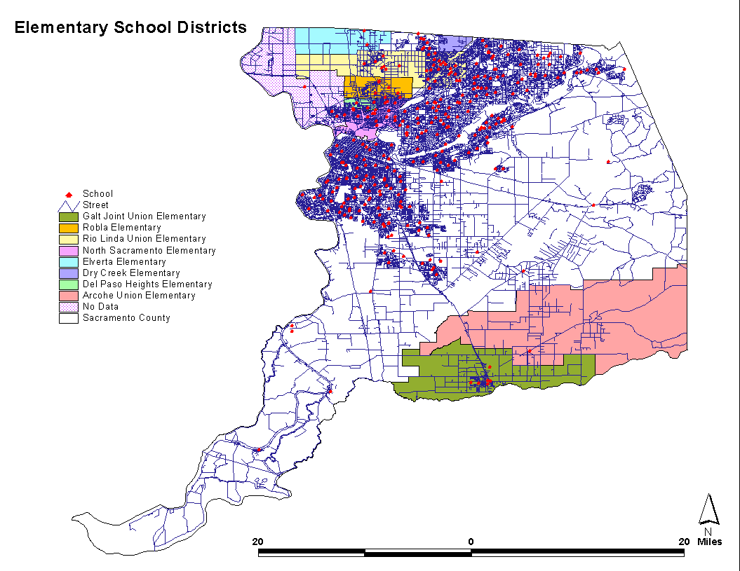
Elementary Schools Layout
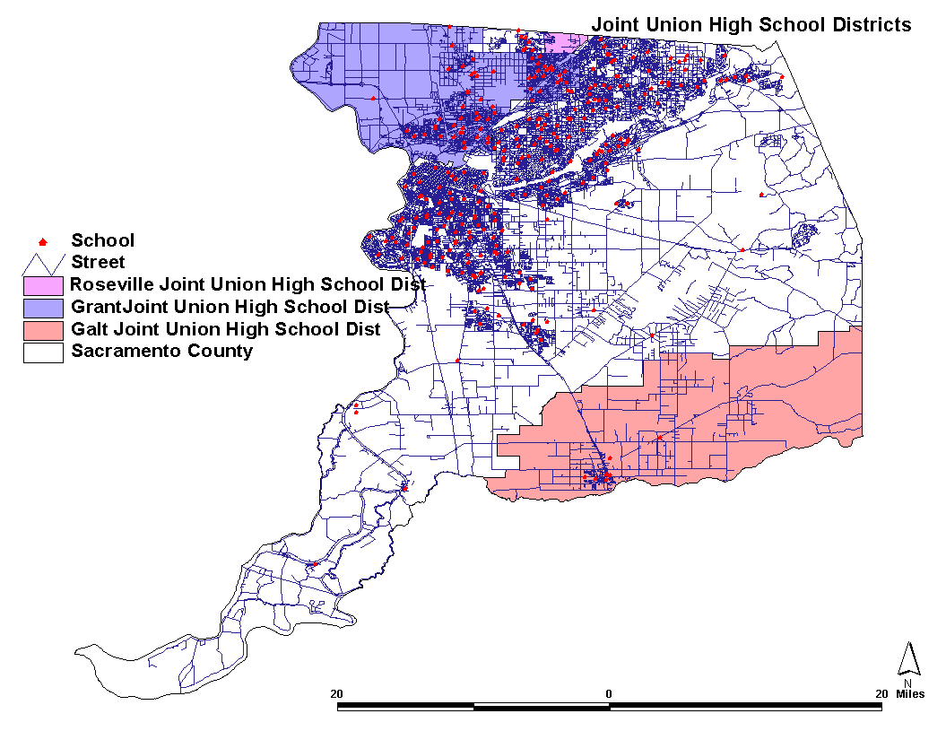
Joint Union High School Districts Layout
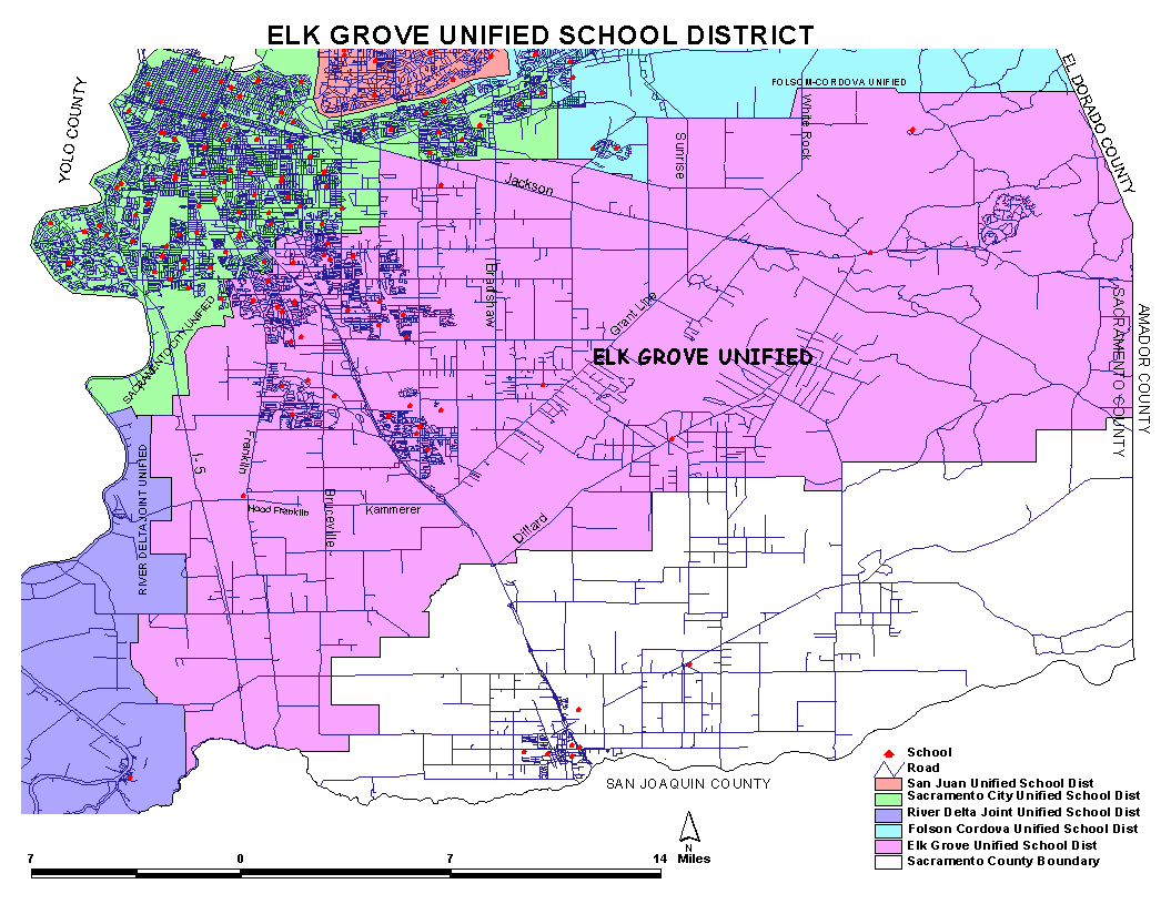
Elk Grove Unified School District Layout
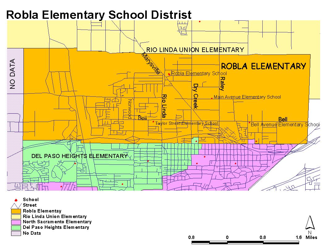
Robla Elementary School District Layout
ANALYSIS
I encountered myriad minor problems in creating this project. All of these problems were quickly corrected with help from my professors or from online help in dealing with software problems. I had three major problems that could not be corrected. These three problems were incomplete data, inconsistent data, and time itself.
The problem with incomplete data could be corrected easily with more time. I could not find latitude, longitude, address, and phone number data for all of the schools. I looked in the phone book under each school to find an address and phone number for schools that didn’t have this data. Some schools I found and others I could not. For the schools, which did not have latitude or longitude data, I intended to go out to each school and use a Global Positioning System receiver to gather this data. This was not accomplished because I did not have enough time to complete this. Ideally a differential GPS receiver should be used to collect the latitude and longitude because it has a better resolution than a hand held GPS unit does. The TIGER street data was incomplete. Not all of the streets had names and other required data to make network analysis possible. Shapefiles need to be created of each school’s individual boundaries. Some plain paper maps with this data exist but are all used within each school. A parent would have to pick a school in the area and ask the school whether his or her address fell within that school’s boundary. Each of these individual maps would need to be gathered and then digitized.
The problem with inconsistent data was that between the three sources some schools were listed in one source but not in another. This is a problem that cannot be rectified at this time.
Time itself posed the most significant problem. This project was given a 3.5 month period for completion. With more time to complete this project I could have made sure all of the schools had latitude, longitude, address, phone number, and grade level information.
CONCLUSION
I still believe that having a functional GIS will make finding information about a particular school easier for everyone concerned. To solve some of the problems in doing this, more accurate data is needed, especially street data. If the street data were complete and accurate then spatial queries could be performed when a parent called the Office of Education and gave their address. Then the person operating the GIS could perform a simple search for which school the caller’s child would attend. If I had more time to work on this project I could also create a database, to be used in ArcView, that had information about each schools teaching staff, administrators, and extracurricular activities. The project I created is a GIS but it does not have all of the functionality that would make finding such information possible.
REFERENCES
California Department of Education, 1998. Sacramento County. California Public Schools Directory, pg. 228-241
http://mapping.usgs.gov/www/gnis/
http://www.esri.com/data/online/tiger
http://www.greatschools.net/gs/ca/sac/town
|