|
California State Parks Recreational Analysis
Sandra Summers
Geography 26: Data Acquisition in GIS
Fall 1999
Abstract:
The project objective was to design and implement a Geographic Information System of campsites and recreational areas in and around California state parks.
Introduction:
There are 265 state parks in California. Associated with these parks are numerous recreation opportunities such as camping, fishing, hiking and mountain biking. My husband and I have amassed a large quantity of reference material and information on the various trails and campgrounds in many of these parks and would like to make this information available to our friends.
Background:
We are avid hikers and mountain bike enthusiasts. We also do more than our share of backpacking and camping. Over the years we have explored much of California, Oregon, Washington and Western British Colombia. Our pursuit of outdoor recreation has cluttered our home with photos, trail maps, books and maps of various scales with scribbled notes and trail markers drawn in by hand. It has also branded us as a recreational reference library to our friends. It seems that whenever one of them decides to travel, we get a phone call requesting copies of maps or directions to trails along their route. We enjoy sharing this sort of information with our friends, however it is not always easy to determine just which sites they are looking for. Locating a specific map among the plethora of them stuffed in the drawers and the filing cabinet can be quite difficult and time consuming as well. Bringing this scattered information together in a Geographic Information System seemed like an obvious solution to our data retrieval problem. I would then be able to easily find relevant trails and campsites on a display map. I would also have access to associated notes in a database that I could link to the graphic. This would greatly reduce the amount of time and effort required to find the requested data.
Methods:
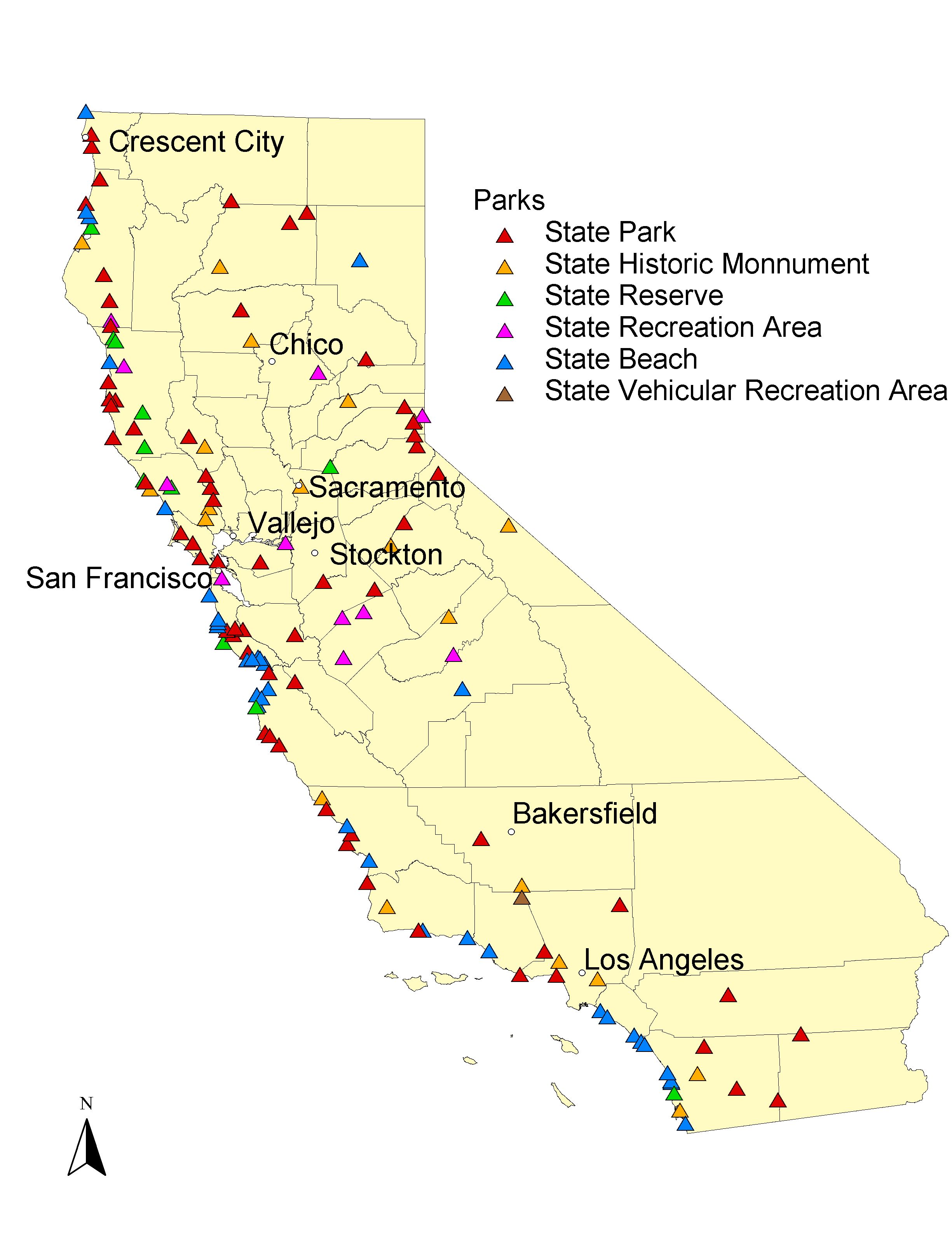
The majority of our friends live, as we do, in California. With this in mind, I Decided to incorporate only the data that I had or could locate on sites in California and leave the Oregon, Washington and British Colombia data for processing at a later date. As I went through the maps and trail guides for California, I noticed that most of the sites that I had information on were clustered around state parks. It seemed logical then to build a base map of California with the state parks plotted on the map and link my attribute information to the parks.
I began by using an existing shapefile of county polygons in Arcview. This shapefile was in an Albers Equal Area projection. The park locations were not as easy. I wanted to plot them at the appropriate geographic locations rather than digitize them onto the map in their approximate locations. I turned to the internet in hopes of finding coordinates associated with the parks. Unfortunately I was unable to find the information that I was seeking. I decided that it was time to visit the California Department of Parks and Recreation office. From this office I was able to acquire a list of all of the state park lands and the facilities available at each site. They however were unable to supply me with the coordinates that I needed.
I looked around further and was able to find a shapefile called "GNIS" and it’s associated attribute table. This table contained the names of geographic landmarks in California and their associated geographic coordinates. Since the park information that I had was all in hard copy format I had to enter it manually into a Microsoft Access database. From there I saved it as a delimited text file which I was able to bring into Arcview and join to the GNIS table. With the tables joined I was able to filter the theme for just the state park lands and symbolize the parks according to their use codes.
I created a related data base table for available facilities such as campsites, picnic sites, fishing and such. I also created tables for bike trail information and hiking trail information such as trail length and difficulty level. My intention is to generate shape files for both of these trail tables by plotting GPS coordinates for them which I have started to gather. I will then link these trail shapefiles to the associated trail tables.
Conclusion:
I have learned quite a bit about gathering and managing data during this project. I was able to organize my data in a more accessible format and have as a result a useful tool for my friends and I to use in our future outings. I also gathered information on the internet for trails that I have not yet explored. I plan to use my project as a grand excuse to grab a GPS unit and venture forth.
References:
Houtte, Melissa, 1999. Regional Information. California Parks Magazine, 45-102.
California Department of Parks and Recreation, 1999. Camping Reservation Guide.
Delorme Mapping Company, 1995. Northern California Atlas and Gazetteer.
Delorme Mapping Company, 1995. Southern California Atlas and Gazetteer.
Earthwalk Press, 1992. Recreation Map of California’s North Coast.
California Department of Parks and Recreation, 1999. California State Parks Official Map. |