Vernal Pool Mitigation
Monitoring Program
Leo Anguiano
Geography 26 - Data Acquisition
Spring 2000
American River College
ABSTRACT
The
primary focus of this paper is on the delineation of natural occurring vernal
pools and the collection of attributes.
The property located in Sacramento is the area of study. ArcView shapefiles were created from GPS
points collected by a Trimble Unit and post-processed for differential
correction. The attributes collected so
far have been inputted in ArcView tables for analysis comparison against newly
constructed vernal pools.
INTRODUCTION
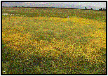
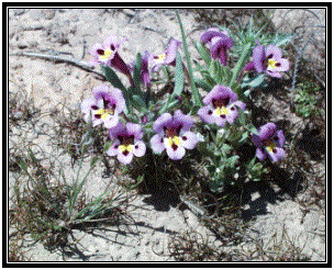
Vernal pools are unique wetlands that fill with rain
water during winter and dry out by summer.
These pools vary in size from small depressions in the earth to large
ponds. A single pool can be home to
hundreds of native plants and animals, many of which are found only in vernal
pools. Because they are home to
endangered species, including several species of fairy shrimp and other invertebrates,
pools are protected by law. When pools
are destroyed by development, they must be mitigated for. Mitigation involves the process of
monitoring existing and newly developed vernal pools through the collection of
certain data elements for comparison / analysis. The primary objective of the Company’s monitoring program is to
determine the relative success of mitigation efforts as compared to established
success criteria. Monitoring is also
designed to provide sufficient data to identify and evaluate the cause of
problems in attaining success should they occur, and assist in devising
appropriate corrective measures.
BACKGROUND
In October 1996, the Company
implemented a vernal pool mitigation project as compensation for vernal pool
losses associated with sand and gravel mining.
The mitigation was developed to satisfy requirements associated with the
U.S. Fish and Wildlife Services’ (USFWS) approval to mine aggregate.
Part of this
mitigation project was the construction and monitoring of 15 acres of vernal
pools. The gathering of monitoring
information related to these pools began in 1997 by Company personnel.
In order to properly
monitor the newly constructed pools, an 80-acre parcel of land containing 10
acres of seasonal wetlands and natural vernal pools was set aside by the Company
as a preservation area for the study and monitoring of these pools. Information is also being gathered and
collected from these natural vernal pools to compare against the constructed
vernal pools. The success criteria are
such that the created pools must meet similar physical, hydrology, edaphic, and
floristic/biological conditions as the natural pools.
An important aspect
of the monitoring program is the development of a GIS database to properly
analyze the information from both groups of vernal pools. Delineation of the vernal pools is a part of
this database that needs to be completed to properly analyze this information
from a spatial perspective.
OBJECTIVE
This report will focus on the collection of attributes
(photos and hydrology) and the delineation of ten randomly selected natural
vernal pools and property boundary in the 80-acre parcel of land. It is hoped that this information will allow
the Company to better monitor newly constructed
vernal pools as part of their mitigation and monitoring agreements.
METHODS
Delineation
The 10 vernal pools (randomly selected by the Company
personnel) were marked with a water measuring pipe at the deepest point of the
pool. These water pipes were used to
differentiate the selected pools from other pools in the area. The property boundary is surrounded by a
cattle fence. Delineation was conducted
by the use of a Trimble GPS Unit capable of post-processing for differential
correction. The Datum used for creation
of the files was NAD 27, California Zone 2.
The perimeter of the fence was used as a
boundary. A rover file was used to
collect points as the boundary was slowly paced. Points were being collected every 2 seconds or so.
The perimeters of the
vernal pools were similarly paced, making sure that a rover file was used for
each of the selected vernal pools for the collection of points. The beginning and ending of the pools were
marked with a flag for minimum overlapping.
After all the
selected vernal pools were delineated, as well as some irrigated wetlands,
post-processing was done through the Pathfinder Office Software. Base files for differential correction were
downloaded from http://www.fs.fed.us/database/gps/wsftp/ftpinfo.htm
internet site. The files were then
exported as shapefiles for ArcView usage.
Photos
Photographs were taken from permanent photo stations to
document seasonal changes and vegetation development of both the constructed
and natural pools. Representative
photos of existing plant species will continue to be taken during the peak
flowering period.
Hydrology
Monitoring
Pool
hydrology was measured by water depth and percent inundation. Water levels in each of the pools was
measured weekly from November through April.
Permanent gauges were placed in each pool at about its deepest
point. Two, three, or four gauges were
placed in some of the larger pools with more than one low point.
The total area
inundated in each pools was given a ranking based upon its percentage of
inundation. The following ranking
system was used:
|
Rank
|
Inundation Area
|
|
3
|
Pool > 80%
inundated
|
|
2
|
Pool 80% to 50%
inundated
|
|
1
|
Pool < 50%
inundated
|
|
0
|
Pool not inundated
|
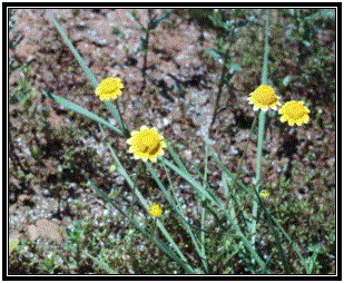
Vegetation
Monitoring
Botanical surveys will be conducted in April. Floristic data will include a list of the
species present, plant cover estimates, and species composition.
RESULTS
Eight visits were made to the site between February and
April, 2000. Hydrology and photo images
were gathered by Company employees visiting the site for monitoring
purposes. The creation of the
shapefiles was done through ArcView.
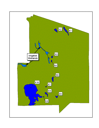
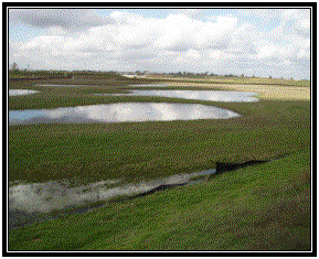
Delineation
The image to the
right indicates the vernal pools that will be used for comparison purposes
against newly created ones.
Most of the vernal
pools were under a tenth of an acre, averaging around 1000 square feet. The largest of these (X10) was just over 3
acres large with several small islands.
There were several
irrigated wetlands in the 80 acre parcel.
At some points, these irrigated wetlands actually joined some of the
vernal pools as inlets/outlets, making the job of delineating these areas
difficult.
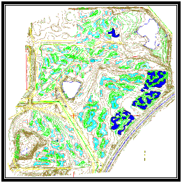
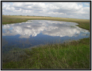
The image to the left is a map of newly constructed pools
the Company has mitigated for. The
vernal pools are colored in dark blue.
These will be compared to the sample pools for water depths, percent of
inundation, vegetative cover, and
vegetative composition.
Hydrology
Water depth was monitored weekly from January to
April. Maximum depths were reached in
mid-February due to low rain levels in December. By the end of April almost all the pools were dry except for the
largest, X10.
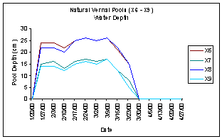
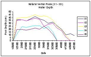
 These water depth measurements will be compared to those of
constructed pools. The standard to be
used is as follows:
These water depth measurements will be compared to those of
constructed pools. The standard to be
used is as follows:
Constructed pools will pond water to a depth and
duration within the range of the control pools.
The range is defined as
within 10 percent of range of the sampled pools.
Vernal Pool Inundation
Table
|
Vernal
Pools
|
Rank
|
|
Jan-2000
|
Feb-2000
|
Mar-2000
|
Apr-2000
|
|
X1
|
1
|
2
|
3
|
2
|
|
X2
|
1
|
2
|
3
|
1
|
|
X3
|
0
|
1
|
2
|
2
|
|
X4
|
0
|
1
|
1
|
0
|
|
X5
|
1
|
1
|
2
|
0
|
|
X6
|
1
|
2
|
3
|
0
|
|
X7
|
0
|
1
|
3
|
0
|
|
X8
|
1
|
2
|
3
|
0
|
|
X9
|
0
|
1
|
3
|
0
|
|
X10
|
1
|
2
|
3
|
1
|
|
Rank
|
3 – Pool
> 80% inundated
2 – Pool 50%
to 80% inundated
1 – Pool
< 50% inundated
0 – Pool not
inundated
|
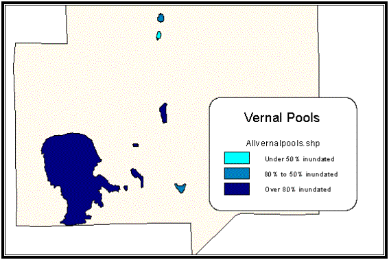
Inundation levels will be used to analyze the natural
pool’s water evaporation / drainage to those of the newly constructed
pools. By evaluating the color of the
pool in the theme, one can evaluate which pools hold more water and at what
time of the season they begin to dry up.
CONCLUSION
First year’s
monitoring results will be evaluated after all information is collected. Some of the analysis that is hoped to be
gained from this are:
The
indication that mitigated pools are establishing a native vernal pool flora and
hydrology within target levels. Vegetative cover can be expected to reach an
equilibrium level at some point while species richness will reach a peak and
then begin to decline as the multitude of early success ional species give way
to the more dominant species typical of the area.
Erosion
indication through water overflow and sediment deposits.
REFERENCES
Company. August 31, 1995. Compensation Vernal Pool Monitoring Requirements.
Company Employees.
April 2000. Personal Communications.
Dept of Fish and
Game, Wetlands Inventory and Conservation http://maphost.dfg.ca.gov/wetlands/vp_prog_rept/vpprogfin3.698.htm
USDA Forest Service,
Global Positioning System Page. http://www.fs.fed.us/database/gps/