Land Use and Restoration Activities
in the Sonoma Creek
Watershed
Tom Bakke
American River College
Geography 26, Spring 2000
Abstract
Geographic information system (GIS) has become a powerful tool for
collecting and analyzing data on environmental impacts. In the Sonoma Creek Watershed in Sonoma
County GIS data is being used to evaluate the various land uses within the
watershed, and to select, implement and evaluate various ecological restoration
activities. While this process is
ongoing, it has attracted the cooperation and coordination of the important
organizations, both public and private.
Introduction
There is a growing awareness in the Valley of the Moon in
Sonoma County that over-development constitutes a threat to the health of the
valley’s watershed and its ecosystem.
This awareness is manifested by the differing opinions over the pace,
patterns and practices of vineyard development. The rapid growth of the wine industry has led to continued
conversion of woodlands to vineyards, erosion problems, concerns over the use
of water resources, and rapid growth of population and its related issues.
This paper has two objectives. The first objective is to identify the Sonoma Creek Watershed and
the various land use patterns that have impacted the watershed. The second objective will be identify and
describe efforts within the past five years to restore the watershed.
The
Sonoma Creek Watershed is a subpart of the Suisun Marsh and San Francisco
Ecological Zone (CALFED, 1998). The
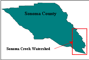
watershed (Figure 1) encompasses most of the Valley of the Moon, beginning in
the North near the town of Kenwood and continuing south to the San Pablo Bay,
approximately ten miles south of the town of Sonoma. The watershed is bounded on the west by the Sonoma Mountain Range,
and on the East by the Mayacama Range, forming the border with Napa
County.
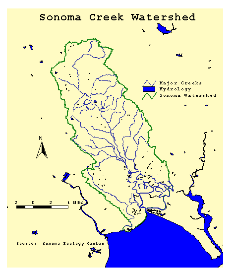
Figure 1
Background
The
fundamental problem is the deteriorating health of the watershed. The Sonoma Creek Watershed currently is on
the Regional Water Quality Control Board’s Impaired Waterbodies List (SSCRCD,
1997). Serious sedimentation and
erosion problems, and those anticipated by replanting and expansion of
vineyards led to the development, in 1993, of a watershed enhancement plan to
address these issues. Many of the
activities addressed in the enhancement plan are still in progress. Concerns about the health of the estuary in
southern part of the watershed has also resulted in a plan for federal
acquisition of this land for a national wildlife refuge (FWS, 1995).
The
main impacts on the watershed are increasing urban development and conversion
of woodland to vineyards. The continued
rapid growth of vineyards, especially on steep slopes, has caused a public
demand for more local governmental control of vineyard practices (Chorneau,
1999; Weiser, 1999). A recent survey
found that 53.4 percent of county residents felt that “too much acreage was
planted” in wine grapes, 52.2 percent felt that “more controls should be placed
on planting vineyards”, and 44.6 percent “[had] concerns about the impact of
vineyards on the environment” (Richard Hertz Consulting, 1999). In December 1999 a county ordinance was
implemented that requires fees and permits for replanting and conversion of
land to vineyards (CACCS, 1999). The
ordinance also specifies the required environmental actions to control erosion
and sedimentation, and regulates or prohibits planting on steeply sloped land,
according to percent of slope.
The
identification, restoration and maintenance of watersheds as the basis of
environmental planning and resource protection (SFEI, 1998) is well
understood. Many activities have been
implemented in the past five years to identify the impacts on the Sonoma Creek
Watershed and to restore watershed to better health. The Sonoma Ecology Center, located in the town of Sonoma, has
become the lead for coordinating these activities. The process of indentifying these impacts is being accomplished
through its GIS Project. The goal of
the GIS Project is to develop a base model of the Sonoma Valley region that
describes the natural features, such as geology, hydrology, topology, plant
communities and animal habitats; and human features such as land use and
infrastructure.
Methods
The
primary method for acquiring land use pattern data was to (1) obtain the
relevant existing GIS shape files from public or proprietary sources, and (2)
develop GIS shape files from printed sources (e.g., maps) and/or aerial
photos. Shape files for the roads
within the watershed were acquired from ESRI as a byproduct of purchasing
ArcView base software. Shape files for
the Sonoma Creek watershed, rivers and creeks and rehabilitation projects were
acquired from the Sonoma Ecology Center through their GIS Project (See www.vom.com/sec
and additional sites in references).
Some
of the shape files obtained from the Sonoma Ecology Center were in North
American Datum 1983 (NAD83), while others were in NAD27. All GIS files were converted to NAD83 to allow
projection within the same view.
Shape
files of the Sonoma Valley appellation regions and the vineyards land use
coverage were initially requested in written form from the Sonoma Valley Grape
Growers’ Association, at their suggestion.
This request was denied.
Therefore, a detailed poster reproduction of the Sonoma Valley
appellation regions (SCGGA, 1999), derived from the GIS files, was
purchased. A sample theme of the
vineyard acreage was re-created for this project by using the Sonoma County streets
shape file as the active theme, selecting “new theme” from the view menu in
ArcView, then using the polygon tool to create the individual vineyards. The attribute file was subsequently edited
to add vineyard owner, identification numbers and acreage.
Data
for creating other polygon shape files were culled from printed materials as in
the manner described above. Data used
for identifying acreage for federal acquisition and protection of wetlands was
obtained from The Final Environmental Assessment for the San Pablo National
Wildlife Refuge (FWS, 1995). Data for
determining acreage of cities and parks was drawn from detailed local maps
(Compass Maps, 1998).
Tables
and other data cited in this paper were identified through internet sources and
through the library of the Sonoma Ecology Center. Primary internet sources included the Center for Environmental
Resources and Evaluation System (www.ceres.ca.gov), the U.S. Department of
the Interior’s Environmental Protection Agency’s Surf Your Watershed (www.epa.gov/surf3),
and Wetlands Information System (See also www.epa.gov).
Results
The
Sonoma Creek Watershed has been severely impacted by development. The major land uses in the Sonoma Creek
Watershed are urban development, vineyards and wineries, and recreational usage
(e.g., parks and golf courses). The
recently completed restoration plan for the watershed states that “vineyards are
the predominant land use in the upper watershed, particularly on the valley
floor” (CALFED, p. 89). The report also
states that “much of the vernal pool, seasonal wetland and oak savanna habitat”
previously present on the valley floor has been eliminated as a result of
agricultural and urban development.
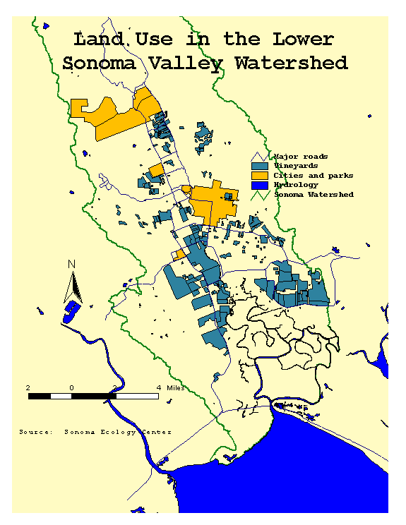
Figure 2 shows the current state of land development within the lower 75
percent of the watershed, with vineyard acreage based on a sample of 208
vineyards (see Methods for a description of how this data was collected). The amount of acreage represented in Figure
2 is 8,431.
Figure 2
|
Table 1 1994 Sonoma Valley Vineyard
Acreage by Slope
(SSCRCD, 1997)
|
Percent
Slope
|
Acreage
|
|
0-2
|
3,166
|
|
0-5
|
678
|
|
0-9
|
2,273
|
|
2-5
|
320
|
|
2-9
|
1,379
|
|
2-15
|
954
|
|
2-30
|
32
|
|
5-9
|
15
|
|
5-15
|
565
|
|
9-15
|
686
|
|
9-30
|
83
|
|
9-50
|
142
|
|
15-30
|
2,242
|
|
30-50
|
680
|
|
30-75
|
97
|
|
50-75
|
21
|
As
previously noted, continuing conversion of land to vineyards has led to public
concern about erosion, since newly converted land is primarily on
hillsides. Table 1 shows the number of
vineyard acres by slope as of 1994. The
table clearly shows that 29.6 percent of vineyards are on slopes of 9-15
percent or greater. Data for new vineyards, or on acreage by slope for the most
recent five-year period is not available since most vineyards are privately
held companies. It is expected that the
recently enacted Erosion and Sediment Control Ordinance will both retard
further development of steep slopes and mitigate the negative impacts of
existing planting, future land conversion and replanting. Futhermore, data on acreage by slope will
be collected and become publicly available through the new ordinance.
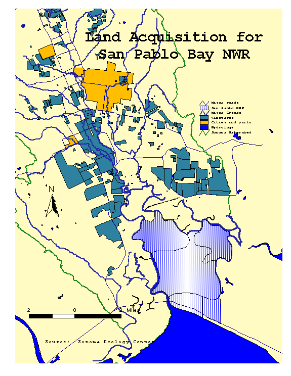
In
the very southern part of the watershed, the ecosystem restoration plan
(CALFED, 1998) calls primarily for the federal government to either directly
acquire estuary and baylands or to gain control through easements. The land thus acquired would then be
included within the authority of the San Pablo Bay National Wildlife
Refuge. This acquisition is important
because this land is the last remaining undeveloped area within the
watershed. Table 2 shows the ownership,
tracts and acres that have been purchased.
Significantly, the acquired acreage would constitute approximately half
of all the existing vineyard acreage within the entire watershed. This area is shown in detail in Figure 3.
|
Table 2 Ownership, Acreage and Acquisition Priorities of Proposed
Additions to San Pablo Bay National Wildlife Refuge (FWS, 1995)
|
Tracts
|
Hectares
|
Acres
|
Priority
|
Interest
|
Current Owner
|
|
Skaggs
Island
|
1,341
|
3,310
|
1
|
Fee
Title (via transfer
|
Dept
of Defense
|
|
Detjen
Duck Club
|
203
|
500
|
2
|
Fee/easement
|
Detjen
Club
|
|
Camp
Three Island
|
587
|
1,450
|
3
|
Fee/easement
|
Kiser
|
|
Haire
Ranch
|
441
|
1,090
|
4
|
Fee/easement
|
Haire
Ranch
|
|
West
End Club
|
313
|
774
|
5
|
Lease
|
State
of Calif.
|
Total
|
2,885
|
7,124
|
|
|
|
Figure 3
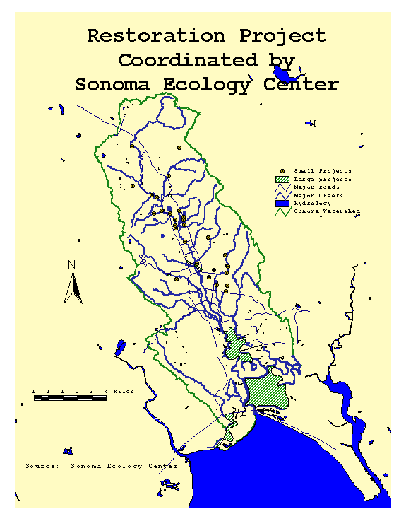
In the past five years 11 major projects and 42 small
projects representing 21 public and private organizations engaged in activities
to restore some smaller area within the Sonoma Creek Watershed. The large projects alone account for 5,374
acres. The major projects focus on
wetlands restoration, such as the Ernie Smith Park vernal pools, Sonoma Creek
Baylands, and Skaggs Island Wetland Restoration. Some of the organizations involved with the smaller projects are
vineyards and wineries, such as B.R. Cohn, Fichtenberg, and Harywood. Other organizations include St. Leo’s
Catholic Church, Indian Springs Ranch, the Southern Sonoma County Resource
Center, and the San Francisco Estuary Institute. The small projects include eradication of non-native plants and
grasses, trail reconstruction such as Arundo Cane, rehabilitation of streambeds
and creeks, and wetlands restoration.
As noted, many of these organizations have coordinated their activities
through the Sonoma Ecology Center.
Figure 4 identifies the locations of some of the most important projects
completed during the past five years or currently in progress.
Figure 4
There
are also additional large ecological projects within the watershed, but without
specific locations identified in spatial format. These projects, identified through the California Ecological
Restoration Projects Inventory (CERPI) and the Watershed Projects Inventory
(WPI), are shown below in Table 3.
These projects range in size from 60 acres to hundreds of acres.
|
Table 3 County-Wide Projects
Impacting Sonoma Creek Watershed
(CERPI and WPI, 2000)
|
|
Project
|
Purpose
|
Lead Agency
|
Dates
|
|
Sonoma
County Gorse Biological Control Project
|
Eradicate
non-native weed
|
Sonoma
County Dept. of Agriculture
|
Jan
88 – ongoing
|
|
Control
of Yellow Starthistle
|
Eradicate
non-native weed
|
U.C.
Davis
|
Apr
95 – ongoing
|
|
Ledson
Marsh Habitat Restoration
|
Eucalyptus
removal
|
Calif.
Dept. of Parks and Rec.
|
Jan
84 – Jan 97
|
|
Oak-Madrone
Woodland Restoration
|
Eucalyptus
removal
|
Calif.
Dept. of Parks and Rec.
|
Jan
94 – Dec 97
|
|
Sonoma
County Klamathweed Biological Control Project
|
Eradicate
non-native weed
|
Sonoma
County Dept. of Agriculture
|
Jan
88 – ongoing
|
|
Sonoma
County Puncturevine Biological Project
|
Eradicate
non-native weed
|
Sonoma
County Dept. of Agriculture
|
Jan
88 - ongoing
|
Analysis
Total
vineyard acreage within the Sonoma Creek Watershed was 13,333 as of 1994. This is approximately the total acreage for
the entire county in 1960. Using the sample theme of acreage, vineyards range
from as small as one quarter of an acre to as much as 625 acres, with the
average vineyard being 40 acres. Published data for 1994, the most currently
available data for this project, shows that approximately 30 percent of
vineyards are on steep slopes, meaning between 9 and 15 percent. (Current vineyard data, in GIS format, has
been provided to the Sonoma Ecology Center, but was unavailable for analysis at
this time.) This trend has become a
serious environmental and public relations problem. Unfortunately, comprehensive
data, including acreage by slope, is not currently available for vineyard
development from 1995 to 2000.
Therefore we are unable to determine either the rate at which vineyard
acreage has grown or how much has been on steep slopes. Continued rapid growth
of vineyards, however, has caused erosion and led to a public awareness of the
need for environmental safeguards.
While much of the watershed has suffered serious over-development in the
recent past, it appears this trend is being arrested and positive restorative
activities are under way. The
implementation of a Sonoma County ordinance to address erosion specifically
associated with vineyard development is one of the major accomplishments.
The
incorporation of the tidal lands in the southern watershed into the San Pablo
National Wildlife Refuge is also a positive step toward restoring the health of
the watershed. The total acquired
acreage is about half of the watershed acreage under wine cultivation.
Finally,
ongoing activities coordinated through the Sonoma Ecology Center will also help
eradicate non-native plant species and restore fish animal habitat.
Conclusion
It
appears the Sonoma Ecology Center GIS Project is well on the way to developing
an integrated application to document and analyze the long-term impacts on the
watershed. However, much more data
needs to be collected and put into spatial format to further identify and
evaluate impacts and ongoing restoration activities, such as the eradication of
non-native plant species. In particular,
long-term data collection will be required to assess the efficacy of the
Erosion and Sediment Control Ordinance on future vineyard development. Further cooperation among the key land users
in the watershed also is needed if success of the restoration plan is to be
realized. Key players would, for
example, include the county assessor providing parcel data, the Valley of the
Moon Water District providing data on usage by area, or just plain volunteers
to convert annotations on topological maps to shape files.
References
Bay Area Watersheds Science Approach: The role of
watershed science to support environmental planning and resource protection. (Version 3). San Francisco Estuary Institute, September 1998.
California Ecological Restoration Projects Inventory
(CERPI).
(http://endeavor.des.ucdavis.edu/cerpi).
Chorneau, Tom.
“Opponents Fear Loss of County’s Natural Habitat.” The Press Democrat, November 2, 1999.
Map of Sonoma Valley. Compass Maps. Modesto, California, 1998.
Ecosystem Restoration Program Plan, Volume II
(Draft). CALFED Bay-Delta Program,
March 1998.
Erosion and Sediment Control Ordinance. County Agricultural Commission, County of
Sonoma, December, 1999). (Note: A copy
can be obtained from the following website:
http://www.sonoma-county.org).
Final Environmental Assessment for the Proposed
Additions to San Pablo Bay National Wildlife Refuge: Solano, Napa and Sonoma
Counties. Fish and Wildlife
Service, U.S. Department of Interior, August 16, 1995.
Richard Hertz Consulting. “The Press Democrat Poll on the Wine Industry.” Published in the Press Democrat
newspaper, November 3, 1999.
Sonoma County Grape Grower’s Association. Sonoma Valley Appellation Regions. Poster produced by Circuit Rider
Productions, Sebastopol, California, 1999.
Sonoma Creek Watershed
Enhancement Plan. The Southern Sonoma County
Resource Conservation District. Sonoma,
California, June 1997.
Sonoma Ecology Center GIS
Project. Sonoma, California. (Can be reached at http://www.ceres.ca.gov/sec/gis.html
or http://vom.com/sec/gis/gisgps.htm).
Weiser, Matt. ‘Vineyard Law OK’d Despite Protests.” The Press Democrat, October 13, 1999.
Wetland Projects Inventory
(WPI). (Can be reached at http://www.nwi.fws.gov) (Also see http://endeavor.des.ucdavis.edu/wpi).