Levee Relocation at Shanghai Bend
Feather River levee district #1
Chris L. Ball
Data Acquisition Geog 26
5/11/2000
Overview
California is home to the most elaborate
river control system in the world. Part of maintaining this system requires
relocating and replacing existing levees. The Feather River levee system at the
Shanghai Bend site has recently been reconstructed. This area which was once
orchards and farmland has seen significant growth as an urban expansion of
South Yuba City.
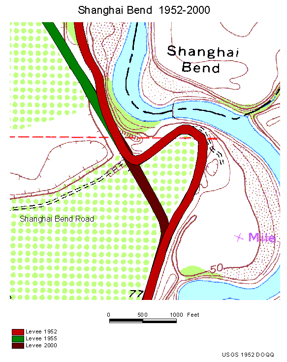
The original levee was situated to follow the
path of the river which changed during the flood of 1907 (Morton). The previous
system at the Shanghai Bend site cut across with a nearly 90 degree turn,
leaving a large section of the levee directly opposing the river flow.
The urbanization of this area motivated
engineers to straighten out the levy system to facilitate river flow and
provide a safer environment for local residents. The project was completed in
October of 1999 by the Army Core of Engineers.
Flooding in the Yuba-Sutter area
The Yuba-Sutter area lies on a flood plain in
the Sacramento Valley and has experienced four major floods in the past one
hundred years.
The 1907 flood killed 4 people and prompted
the building of the Oroville dam. The current levee system is based off the
levees constructed at this time (Morton).
The flood of 1955 killed 38 people and caused
over $20,500,000 of damage. The levee failure in the 1955 flood occurred near
the Shanghai Bend site.
The 1986 flood initiated the proposal for the
Yuba County Levee Restoration and Enhancement Project, which was enacted prior
to the 1997 flood.
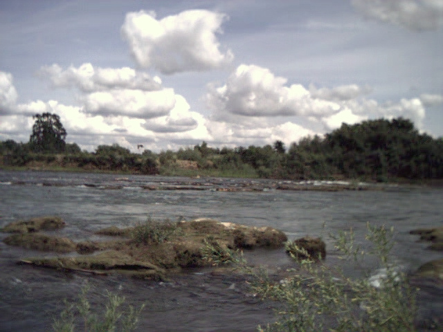
Shanghai Bend Site
The Shanghai Bend site is located near the
section of the levee that failed in 1955. The levee was relocated at that time approximately
150 ft. to the west. A section of the levee further south, directly across
Shanghai Bend was left curving a nearly 90 degree turn which impeded water
flow. This section of the levee was removed and a straight section constructed
in its place.
Levee Construction
"This is one of the
problems with engineered flood control systems...They encourage development in
the most flood-prone areas. People think they are completely protected by the
flood control system, but in truth such systems are inherently unreliable.
Damage from floods in this country has actually gone up despite our huge
investment in flood-control infrastructure." ~Philip Williams, Civil
Engineer(Pottinger)
Levees are constructed from earthen
materials, sand, soil, and clay, but older levees were made with whatever
materials were available. Often after a flood had subsided, levees were
reconstructed with the left over debris. The result was poorly constructed
sandy levees which are more prone to failure (Vogel).
Levees are broadly classified as either
"Urban" or "Agricultural". The type of levee built is
determined by its function and both types have different structural
requirements (US A.C.E.).
The Shanghai Bend levees were built when this
area was primarily agricultural, and were thus built with different parameters
in mind. The encroaching urbanization has forced engineers to address these
antiquated levees .
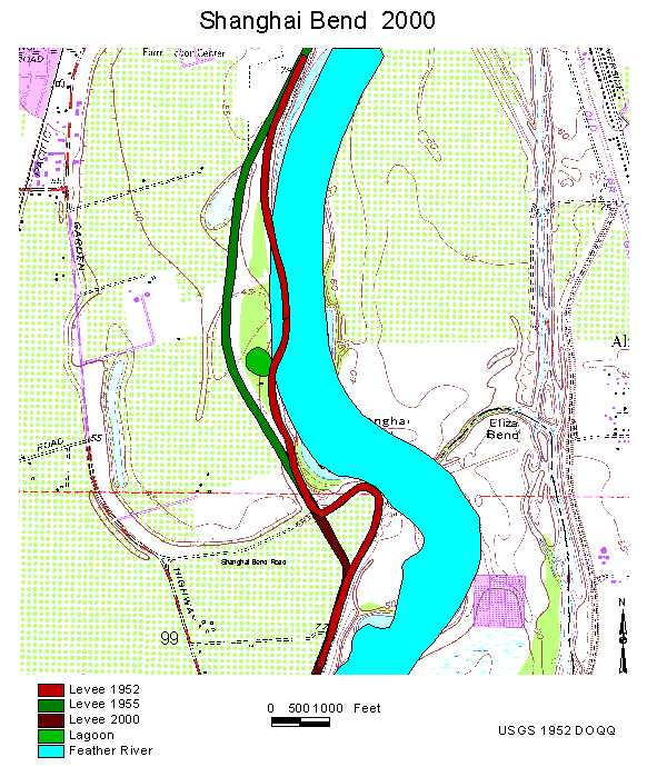
|
Levee 1952
|

Levee 1955
|
Levee 2000
|
Levee Failure
Though overtopping of the levee is a concern,
seepage through a levee is the primary cause of its failure. Tree roots,
gophers, rain and the river flow itself deteorite the levee over time. In all
four of the Yuba-Sutter floods levee failure was attributed to seepage.
(Morton) Engineers pulled core samples from Feather River levees and found a
layer of clay on top, which resists water flow, but found silty/sandy soil
lower down which has a high porosity. These levees are more likely to fail in
flood conditions due to their composition. (Vogel)
Slurry walls are vertical channels filled
with SCB (Soil, Cement, Bentonite) that prevent seepage. (Morton) Bentonite is
a clay which is derived from volcanic ash. Bentonite has the useful property of
expanding several times its original volume when immersed in water (Klein 513).
The walls run down the center of the levee
and older levees can be retrofitted with slurry walls. The Yuba County Levee
Restoration and Enhancement Project initiated on January 24, 1997, proposed to
rebuild 22 miles of levee, including retrofitting existing levees with slurry
walls, in the Yuba City - Marysville area (Vogel).
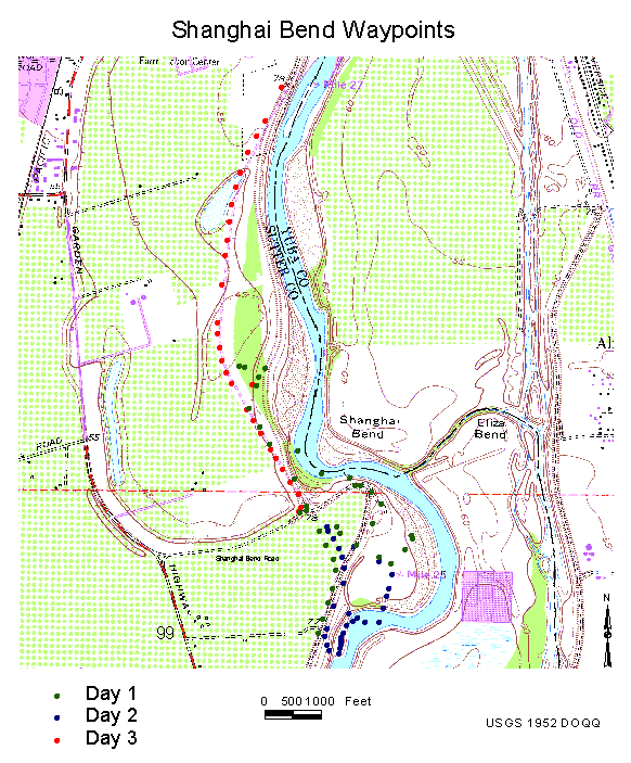
Data Collection
I collected data along the levee at Shanghai
Bend using a Garmin 12XL GPS receiver. The data was stored as waypoints and
were averaged for 1 minute or until fluctuations ceased. The data was collected
over a period of 3 days, and averaged +/- 15 feet (maximum deviation 0f +/-
38ft. on first day).
The waypoints were used to draw out the
changes made to the levy in the past 93 years at the Shanghai Bend site.
The Digital Ortho Quarter Quad (DOQQ) was
produced by the USGS in 1952, updated in 1973. This map does not show the
current locations of the levees in this area.
Conclusion
The Shanghai
Bend levee has been relocated and reconstructed to provide adequate protection
for the residents of South Yuba City. The levee was rebuilt to meet urban levee
standards and the park area itself has seen several landscaping improvements.
The relocation should improve river flow and help prevent flooding in the area.
Resources
Klein, Cornelis; Hurlbut, C.S.; Manual of Mineralogy; John Wiley 1977
Dingman, S. L.; Physical Hydrology; Prentice Hall 1993
Pottinger, Lori, "California Flood Control System Springs Leaks",
World Rivers Review, Vol 12, #1, February 1997
Vogel, Nancy; "Ancient Levees Targeted", The Sacramento Bee - Floods
of '97
Morton, R.C.; Safe Levee Homepage, http://www.escalera.com/safelevee
U.S. Army Corps of Engineers; Memphis District, General Levee Information
http://www.mvm.usace.army.mil/floodcontrol/Levees/levees.htm
DRG Exchange; http://216.36.33.21/~mgreger/GIS/exchange.htm
Equipment and Software
Garmin 12XL GPS recover
IXLA SuperPro Digital Camera
ArcView3.1


