THE MERCED CAMPUS PARKWAY
ALIGNMENT
STUDY
Geography 26 –
Acquisition of Data
Paul Veisze –
Instructor
Jim Kay - May 11, 2000
Abstract
The San
Joaquin Valley will experience significant growth in the next 20 years. Merced
County, within the San Joaquin Valley, will face growth from migration, births,
and from the soon to be built University of Merced that will open in 2004. This
paper examines the Merced County Planning process as it solicits public input
and collaboration for planned placement of roads and streets that will serve
the city of Merced and the new University Campus. Two public meetings were held
to obtain public input for the proposed alignment of streets. These two
meetings, the supporting information and maps, will be described and analyzed.
Introduction
The
San Joaquin Valley of California, an area that includes eight counties and over
20% of the land area in the state, is projected to grow from less than 4
million people today to over 6 million by the year 2020. This growth, which will
occur in and around the current urban centers, will impact agriculture, the
primary industry in the San Joaquin Valley. All the cities and counties in the
San Joaquin Valley will need to develop long range plans to accommodate the
employment, education, recreation and infrastructure needs of this increased
population.
The
City and County of Merced are currently in the midst of such planning because
the University of California decided to place its 10th campus in Merced County,
six miles from the Merced city center. By 2020 the student population of this
new campus will grow to 25,
000. The Virginia Smith Trust donated
the land for this new campus, in excess of 2000 acres, to the University of
California. Adjacent to the campus land is
another
8500 acres that will be developed concurrently to provide industrial,
commercial, retail and residential facilities for a new University Community.
It is estimated that by 2020 the population of this new community, excluding
the campus, will be approximately 30,000. The city of Merced, exclusive of the
new campus and the University Community, will grow from its 2000 population of
62,000 to over 100,000 by 2020. In twenty years or less Merced and its
immediate area will have an estimated population of more than 150,000.
A
project of this size involves planning, coordination and the inclusion of many
stakeholders in the decision making process. The University of California
initiated its decision making process in 1988 and made its decision to locate
in Merced County in 1995. Since 1995 the University has collaborated with
Merced County to develop environmental impact reports, and to support community
participation in decision making about the infrastructure development that will
be needed adjacent to the campus. A major concern for the University and Merced
County and all other stakeholders is the location of access roads to the new
campus.
In
1996 Merced County updated its long-range plan to include access to the new
campus. This plan identified a need for access from the north and from the
south, of the campus, directly connecting to the nearest freeway, Hwy 99. The
county determined that funding will be available for one project and chose to
develop a plan for streets and roads that will access the new campus from south
of Merced on its east side.
When the
University of California selected Merced County as the location of its 10th
Campus many planning activities were initiated. The City of Merced amended its
General Plan to acknowledge the new University Community area and to plan for
development to the North and East of the current boundaries of the City of
Merced. Part of this plan amendment identified the need for new transportation
infrastructure that would run North and South and connect the existing Hi-Way
99 to the University Community area. A major overpass and interchange for the
Mission/Healy area has been under discussion and planning for 12 years. That
project is a part of the State of California Transportation plan and may be
eligible for Federal and State Funding in the coming years. The University of
California began to survey and study the new campus site to determine
ecological and environmental impacts and to identify the State, Federal and
Local agencies that have an oversight responsibility for any proposed
development.
The County of Merced, after
consultation with the University and City of Merced and other interested
parties, established an advisory committee with the responsibility for
developing a University Community Plan. This plan, upon completion, will
identify the infrastructure, and other services needed for the development of
the University Community over the next twenty years. This plan will also
develop a list of major activities to be addressed and provide recommendations
to the County Board of Supervisors when they address site selection, service
needs, and the identification of needed resources.
Staff from the
Merced County Department of Public Works developed the first major activity
identified in the University Community Plan, The Campus Parkway Route Alignment
Study. The purpose of the study is to improve future
transportation in the Merced regional area and to access the University
Community and the UC Merced campus. The goals of the project are to serve
Merced’s eastern area industrial growth, North Merced and the University
Community. Other project objectives include providing a utility corridor,
transit corridor, and a bicycle connection. This study and its recommendations
will be the basis for preparing an Environmental Impact Statement
/Environmental Impact Report (EIS/EIR) under the joint direction of Merced
County, The California Department
of Transportation (Caltrans), and the Federal Highway Administration (FHWA).
Methods
Two public Meetings were
scheduled, one in downtown Merced, March 18, 1999, and the other June 30, 1999,
at the Fish and Game Building, near Lake Yosemite which adjoins the southern
boundary of the proposed University Community area. Prior to the meetings the
Department of Public Works mailed meeting notices to some 1800 addresses
including: property owners near the
study area, environmental organizations, county government and cities within
the County of Merced, elected officials, transportation planning agencies, and
civic and service organizations. A notice of the meeting was published in two
local newspapers on four separate dates prior to the meeting dates. These
notices included an e-mail contact point, jser@co.merced.ca.us and a web site www.campusparkway.com
where individuals could obtain information.
A newsletter, summarizing the study issues, was published after each
community meeting and mailed to all participants. Copies of the newsletters
were posted to the website.
The public meetings were organized, formatted and conducted in two
different ways. The information presented at each meeting was similar however
the maps and diagrams available at the June 30 meeting were truncated at the
boundary of the Planned University Community that will be located north of the
Alignment study area. These maps did not show the area north of the Alignment
Study and how it was situated in relation to Hi-way 99 and other roads in the
area.
The March meeting, organized
like a town hall meeting, was held in large public meeting room in central
Merced and scheduled from 7:00 pm to 9:00 pm. The purpose of this first public
meeting was to inform the public about the project, to present preliminary
alignments, identify issues in connection with the new University Community and
get input on the proposed alignments. County staff using power point slides
with maps and sketches hung up on the walls presented the information. Following the presentation questions were
solicited from the audience and then the audience was asked to complete and
submit a questionnaire.
The June meeting was advertised as a Open House which was scheduled
from 4:00pm to 8:00 pm. Study objectives were: advance alternatives that best
meet the purpose and need; provide a major access route for the City of Merced;
serve planned growth for Merced’s eastern industrial area; Merced’s northern
development areas; and the planned University Community. The large meeting room was divided into the
following information stations:
·
A
ten minute video which described the alignment project;
·
Overview
of the purpose and goals for the project;
·
Key
issues of community concern;
·
Maps
of the study alignments;
·
Information
about the environmental process;
·
Recap
of long-term regional planning efforts;
·
Concept
plans for the new University and surrounding community
The Department of public works staffed the information booths.
The invitees entered the room at their convenience during the scheduled
time, moved through the information stations at their own pace, asked questions
of staff who were present, had some refreshments, if they wished, and then sat
down and completed the comment sheet. Displays were provided, including:
·
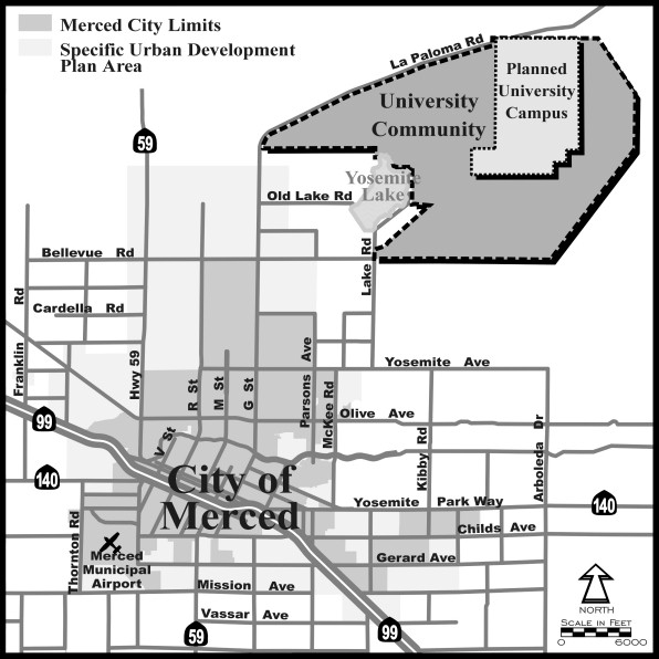
Map
showing the projected direction of growth for the city of Merced. Fig. 1
·
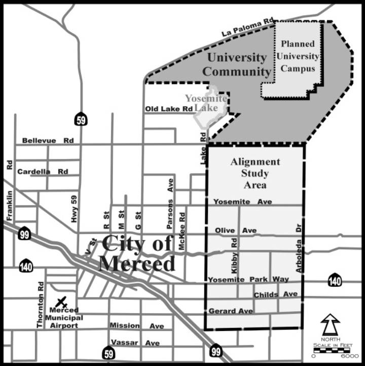
Map
showing the Alignment Study Area in relationship to the City of Merced
The University Community and the Planned
University Campus. Fig. 2
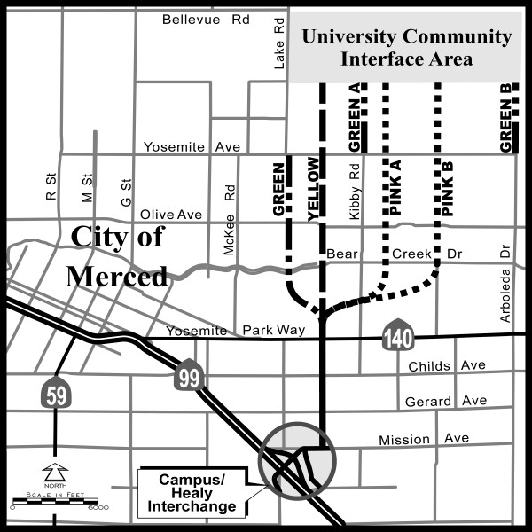
·
Alignment
proposed March 18, 1999 Fig. 3
·
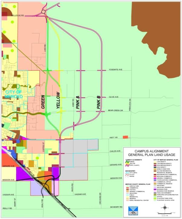
A
land-use map showing all four alignments overlaid on the City and County
General Plan land use designations. Fig. 4
·
Campus
Alignment General Plan Land Usage Legend (Enlarged). Fig. 5
·
An
aerial photo of the northern portion of the alternative routes highlighting
the location of all sensitive biological
resources that have been identified
and mapped to date. (Copy of this photo not
available and not included in
this report.)
·
An
aerial photo of study area overplayed with alignments options.
(This photo is not included in this report.)
Fig.
1 Map showing the projected direction
of growth for the city of Merced.
·
Fig. 2. Map showing the Alignment Study Area in
relationship to the City of Merced the University Community and the Planned
University Campus.
* Fig.
3 Alignment proposed March 18,
1999
·
Fig. 4 A
land-use map showing all four alignments overlaid on the City and County
General Plan land use designations.
Results
Town Hall
Meeting – March 18, 1999
Approximately
130 persons attended this meeting. Following the presentations there were many
questions and some suggestions for other access routes to the new University
Community. The discussions and comments continued for some time and some
participants left the meeting. The remaining participants were asked to
complete a questionnaire and indicate any areas of concern and rank their
preferences for road alignment to the University Community. The participants
completed 30 questionnaires. Responses are shown in Table 1.
Table 1.
Surce: Merced County Summary Report - March 18, 1999 Meeting.
Many speakers
expressed concern that all the alignments go through what they consider is
prime agricultural land. The impact on farming operations, such as agricultural
equipment access to orchards and fields, was also an issue. There was little
agreement on the proposed alignments presented. There were questions about the
width of the access roads and if overpasses were planned for major
intersections. One participant observed that the team should consider parallels
to Santa Clara County’s growth and how development of street and roads induced
growth. Numerous participants recommended that the environmental team consider
a northern access route to the UC campus/community. One of the frequently
mentioned reasons to support the northern option was to preserve agricultural
land and to minimize impacts east of Merced and west of Arboleda. Participants
noted that land to the north of Merced has limited agricultural value.
Open
House - June 30, 1999
Approximately 150 persons attended the event.
Individuals attending the meeting were requested to complete a comment sheet,
which specifically asked their preferred alternative but did not ask them to
rank the preferences that were under discussion. Only the first preference was
tabulated if multiple preferences were given by the participants. Attendees
were asked whether any alternatives should not be considered further, any
comments on the proposal to eliminate alignments Pink A and B, whether they
represented a group, and any other comments. Fifty-three comment sheets were
completed the results of which are listed in Table 2.
Table 2
Alignment
Preferences
(based on first choice listed, if
more than one alignment preference is stated):
|
Green
|
Alt. Green
|
Yellow
|
Pink A
|
Pink B
|
No
Preference
|
|
20
|
3
|
25
|
0
|
2
|
3
|
Opposition
to Any Alignments:
|
Green
|
Alt. Green
|
Yellow
|
Pink A &
B
|
East
Alignments
/ Arboleda
|
None Listed
|
|
8
|
1
|
5
|
15
|
2
|
20
|
Comments
on Eliminating Pink A & B from Further Consideration:
|
Concur with
eliminating from consideration
|
Keep Pink A
& B under consideration
|
No comment listed
|
Other comments
|
|
25
|
3
|
22
|
2
|
|
|
|
|
|
The results of
the questionnaire indicated a preference for the Green and Yellow alignments.
All other alignments listed in the comment sheet generated little or no
support.
Preferences
regarding alignments that should no longer be considered indicate that Pink A
and B should be dropped from further evaluation. Nearly half of the respondents
stated that they concurred with the proposal to eliminate the Pink A and B
routes. A small number of respondents indicated that the Green and Yellow
alignments should no longer be considered (eight and five, respectively).
Staff
recommended that the Green and Yellow options should be considered. Final
decision on an acceptable route will be based on the results of the EIR/EIS,
which will be finalized in January of 2001. A copy of the map showing the Green
and Yellow routes proposed is shown in Fig. 6.
Fig. 6 Refined Alternative
Alignments – Campus Parkway Route Alignment Study.
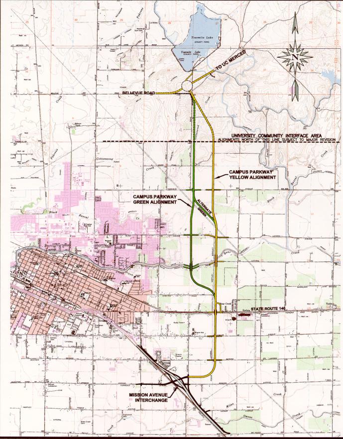
The Merced County Planning Dept produced
the refined alternative alignments map. It appears to be an overlay on the
Merced topo map similar to the land use map that was distributed at the June
30,1999 meeting.
The aerial maps that were available for
participants to view were not available for inclusion in this report.
Analysis
Too many objectives
and a lack of focus on the alignment study goals, at the first meeting,
resulted in a majority of participant
responses that rejected the proposals offered and presented an option that
could not be carried out due to legal and financial constraints on the
county. The first meeting agenda was
too extensive and complex for the limited time scheduled. The scheduled
starting time of 7:00 p.m. was too late in the day and many participants left
the meeting without completing the questionnaires which were to be the basis
for community input into the decision making process. A potential disaster was
avoided when the Merced County Staff focused their study objectives and
developed a different participatory structure for the second public meeting.
Some maps and
supporting material provided for the two meetings were incomplete, and
contradictory. Some maps pictured a different configuration for the Healy
interchange, which will be the connector to the Campus Parkway. Map legends
were practically non-existent and no meta-data was provided. To my knowledge
the private consultants who did much of the support work to produce the
information materials were not acknowledged. Maps presented at the June 30
meeting omitted any delineation or reference to the proposed University
Community or the UC Merced campus.
County
officials should have clearly described past zoning and transportation planning
decisions and how those decisions constrained any planning connected with the
Campus Parkway Study.
Conclusion
Land use
planning is a long and complicated process that requires the management and
presentation of large amounts of data and information to many stakeholders
including the public. Merced County did not prepare well for their first
community input meeting. They regrouped, and restructured their pubic process
and secured input and information they can use to decide a road alignment that
will comply with planning requirements at all levels of government. Much work remains to be done. After the
EIR/EIS is concluded in January 2001, final route selection will commence,
followed by property purchase and then construction. It is estimated that the
Campus Parkway project will be completed in 2004-2005.
References
Campus Parkway
Route Alignment Study, Summary Report, Open House Meeting,
June, 30, 1999 County of Merced, Department of Public
Works
City of Merced
- Revised General Plan 1997
URL: http://www.ci.merced.ca.us/commdev/plnpamph.htm
Merced Campus Parkway Alignment Study, Summary Report, Public
Information Meeting, Mar. 18, 1999
County of Merced, Department of public works
Merced County
Association of Governments (MCAG) Apr. 2000
URL:
http://www.mcag.cog.ca.us/publicat.htm
Merced County - University Community Plan Planning Principles Framework Revised March 13, 2000 URL:
http://www.merceducp.org/planning_principles.htm
University of
California – Merced University
Community Plan Updated Mar 2000
URL : http://www.ucmerced.edu/physplan/concept/concept.htm
Virginia Smith Trust Mar. 2000
URL : http://www.merced.k12.ca.us/smith/smith.html