|
A
Case for the Use of GPS in Flood Zone Analysis of Properties
|
|
Jim Mars
Geography 26 - Data Acquisition
Spring 2000
American River College
|
- INTRODUCTION
Everyday
thousands of flood determinations are being completed on properties across the
United States. Industry designed Geographic Information Systems (GIS) can
automatically assess most property locations; however, there are properties
that can only be processed through manual mapping analysis. These types of
properties usually fall into one of four categories: new construction (newly
parceled lots, new streets, new addresses), rural properties with non-standard
addresses (rural route and box) or with addresses that cannot be geocoded
accurately, manufactured homes that are placed at locations with unassigned
addresses, and locations that are borderline to 100-year flood zones and must
require accurate analysis of the property.
This paper will
discuss the viability of using a global positioning system (GPS) for accurately
determining the location of these properties for flood zone analysis.
- BACKGROUND
In 1968, the U.
S. Congress created the National Flood Insurance Program (NFIP) with the
passage of the National Flood Insurance Act. This program was designed to
provide an insurance alternative to disaster assistance caused by floods.
Property owners in participating communities can purchase insurance protection
against losses from flooding. Communities become participants in the NFIP based
on an agreement with the Federal Government that states if a community will
adopt and enforce a floodplain management ordinance to reduce future flood
risks to new construction in Special Flood Hazard Areas, the Federal Government
will make flood insurance available within the community as a financial
protection against flood losses. In support of the NFIP, the Federal Emergency
Management Agency (FEMA) produced Flood Hazard Boundary Maps (FHBMs), Flood
Insurance Rate Maps (FIRMs), and Flood Boundary and Floodway Maps (FBFMs).
These maps were developed with the help of the Army Corp of Engineers using
topographic maps, field surveys, and historical flood data.
Congress expanded
the scope of the NFIP when it passed the National Flood Insurance Reform Act
of 1994. In this legislation, a process was put in place for identifying
properties located in high-risk 100-year flood plains and requiring insurance
for those properties. It also established rules for new construction in
100-year flood zones. The summary of the process and rules was that any time
Federally regulated lending institutions made loans (new homes or businesses,
refinances, etc.), a flood determination must be completed for that property
and any structure(s) on property. It also established that flood determinations
must be completed by a guaranteed flood zone determination company. Prior to
this law, flood zone determinations could be completed appraisers, surveyors,
or just about any who had flood maps for the location.
- METHOD
Most determination
companies use an industry designed GIS for completing flood zone requests. The
systems combine a base street map layer with a layer of the digitized flood
zone maps. This enables the system to complete automated flood zone
determinations for properties by geocoding an entered address and providing the
flood zone information from the flood map layer. Many properties, however, may
not get automated “hits” because the system simply cannot geocode the submitted
address. The address could be a new property location (new construction or
newly parceled land), a rural property with a non-standard address (rural route
and box), or a property with addresses that cannot be geocoded accurately.
Currently, these
property locations have to be mapped out manually using additional mapping
resources such as, updated local and regional book and paper maps, legal
descriptions, subdivision plats, and tax parcel maps. Most of these resources
are not free; in fact, they can be very expensive and hard to obtain. This
combination of time, money, and labor can hinder a flood zone determination
company’s ability to be profitable.
A solution to this
problem could come from the use of Global Positioning System (GPS) receivers. A
latitude/longitude coordinate for a property could provide supplemental
location data to the traditional property address. Great! How will the
determination companies obtain this additional data?
Anytime a property
is being sold, an appraisal report must be performed. If a licensed appraiser
had a GPS receiver when the site inspection was done, this person could simply
mark a waypoint at the front door of the home. The latitude/longitude along
with the metadata such as, the date and type of GPS receiver used, could be
recorded as part of the report. These reports are included in the loan
documents, which could be forwarded to the determination company at the time of
the flood determination request. This additional information becomes very
useful when manual mapping is necessary for completing flood zone analysis. The
mapper can simply enter the latitude/longitude into a geocoding program and
find the property site instantly.
- DATA
AQUISTION
To demonstrate the
process I described, I used a Garmin 12xl GPS receiver and marked waypoints at
three locations. One location was my house, which was built in 1998.The other
two locations are new homes that are currently under construction in a new
subdivision. The streets in that subdivision were completed just last January
(2000); thus, they will not appear on any mapping programs or maps at this
time. The street my home is on can be found on updated maps of the area, but
still hasn’t been digitized into mapping programs.
After
marking the waypoints with the receiver, I recorded the latitude and longitude,
date and time, location description (property address), and GPS receiver used.
This information was made as a data table in Excel ‘97. I then took this
information for use on three separate geocoding systems.
The first was the Delorme Street Atlas USA
7.0. This system can download and import latitude/longitude coordinates and
display the locations with marker icons. It also has a standard input window,
which I used for my properties. This system also accepts the latitude/longitude
coordinates in degrees/minutes/seconds or decimal form.
The second system
I used was the Microsoft Streets 2000 program. This system can also import the
coordinates; however, the input window requires the latitude/longitude to be in
decimal form.
The third system I
used is an industry designed GIS system called Geolocator. It has the base
street map information with a digitized flood zone layer. This system proved
more difficult, however, because it does not have latitude/longitude entry
fields. It requires the user to get to the regional area (zip code) first, and
then a latitude/longitude input window can be accessed. The advantage this
system provides is that once the coordinates are marked, flood data is
instantly available.
- GPS
WAYPOINTS AND GEOCODING RESULTS
Excel Table:
|
Waypoint ID
|
Location Description
|
Waypoint Description
|
year built
|
Latitude
|
Longitude
|
Date
|
GPS Receiver
|
|
|
|
|
|
|
|
|
|
|
1
|
1534 Cushendall Dr,
Roseville, CA 95747
|
single-story home
|
1998
|
N38 45.573'
|
W121 20.559'
|
05/01/2000
|
GARMIN 12XL
|
|
|
|
|
|
|
|
|
|
|
2
|
1618 Buckwood Dr,
Roseville, CA 95747
|
two-story home
|
2000
|
N38 45.599'
|
W121 20.261'
|
05/02/2000
|
GARMIN 12XL
|
|
|
|
|
|
|
|
|
|
|
3
|
1603 Etchingham Dr,
Roseville, CA 95747
|
single-story home
|
2000
|
N38 45.505'
|
W121 20.176'
|
05/02/2000
|
GARMIN 12XL
|
|
|
|
|
|
|
|
|
|
Delorme
7.0:
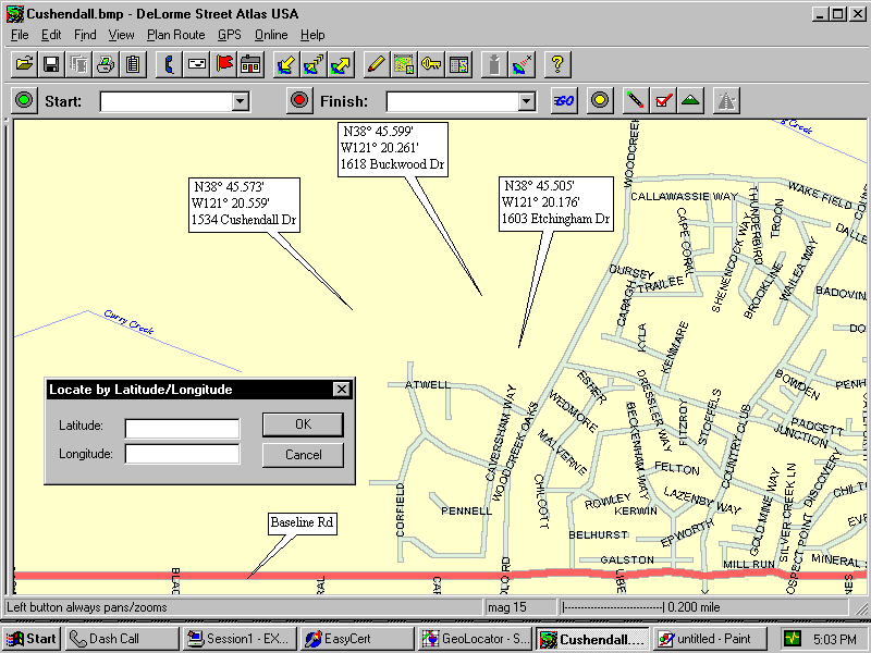
As you can see on the above map,
the streets are not yet digitized at the latitude/longitude for these
locations.
Microsoft Streets 2000:
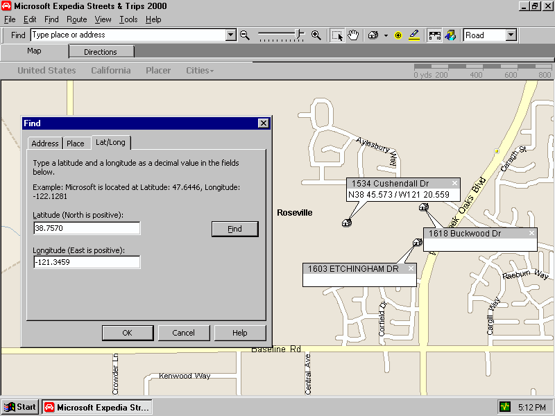
Again the streets are too new to be
shown.
Geolocator:
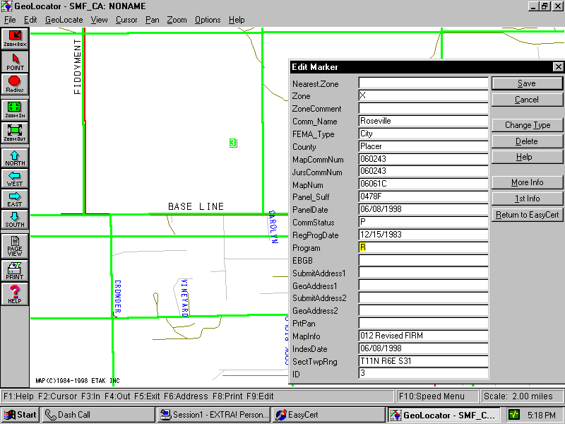
The Geolocator map above provides
instant flood zone data at the latitude/longitude coordinates.
- CONCLUSION
Is there a viable
of use for GPS in completing flood zone determinations of properties?
For flood
determination companies, the ability to acquire latitude/longitude coordinates
for property locations could be a very valuable resource. Most company’s
automated systems run between 50 to 70 percent “hit” ratio on the total volume
of requests. That means 30 to 50 percent of the properties must be manually
mapped. If an industry designed GIS system could be programmed for
latitude/longitude input, a majority of these determinations could also get
automated “hits”. This would leave only a small percentage of properties to be
manually mapped, saving time and money in extra resources and labor.
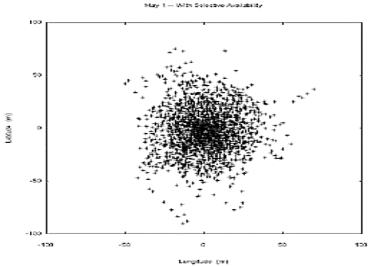
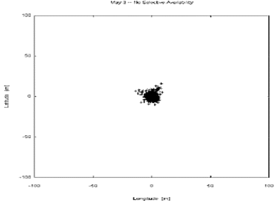
How accurate are
latitude/longitude coordinates when a waypoint is marked on a GPS receiver?
On May 1, 2000,
President Clinton announced that the United States would stop the Selective
Availability (SA) transmission that limited the accuracy of civilian use GPS.
Before this action, the Garmin 12xl accuracy was + or – 100 meters. After SA
was turned off, the unit’s accuracy improved 10-fold to + or – 10 meters. The
following diagrams illustrate this:
Before:
After:
- REFERENCES
The Federal Emergency Management
Agency’s (FEMA) National Flood Insurance Program (NFIP) web site, “Introduction
to the NFIP”, http://www.fema.gov/nfip/intnfip.htm
The Garmin web site, “Decision To Discontinue
SA Announced, GPS Position Accuracy Increased”, http://www.garmin.com/whatsNew/announcements2000/announcements01.html
- DATA
SOURCES
Garmin 12xl GPS receiver
Delorme Street Atlas USA 7.0
Microsoft Streets 2000
Geolocator, Geologix Co.,
Placerville, CA
America’s Flood, Inc., Rancho
Cordova, CA