|
Abstract
This paper reviews a few conditions that can effect the accuracy of GIS spatial data. The conditions that will be described include the effect of combination of data sets, the differing characteristics of the predominate vertical datums currently in use, and the effect of the passage of time. A brief look will also be taken at little-known differences in the value of one our most common units of measure, the foot.
Introduction
Consideration of metadata is an important part of GIS projects. At the beginning of the project, some or all of the information required may be gathered by searching metadata in a data clearinghouse, such as the FGDC Clearinghouse ( http://www.fgdc.gov/, then click on "Clearinghouse"). Search engines at the clearinghouse site scour metadata of GIS information that has been submitted by entities around the globe. Data sets that match the search parameters are then listed for the user's consideration. If the data appears suitable, it can be downloaded into the user's GIS. But how does a user know if data is suitable? Review of the metadata will disclose useful information such as accuracy, time period, geo-referencing system and such, but it will not make a decision. It is up to the user to decide whether the data is suitable for his/her project, based on the information provided in the metadata.
If only one data set is necessary for a project, the "suitability" decision will be straightforward. The data will either meet the project criteria or not. But GIS projects often entail the analysis of combinations of multiple data sets, so the decision becomes more complex. Instead of, "Is this data appropriate?", the question becomes, "Is it appropriate to combine these different data sets, with their differing accuracy's, time periods and geo-referencing systems"? For instance, will your project yield acceptable results if you combine NAD83 horizontal data with NAD27? What about NAD83 and WGS84, would that be better or worse? How much difference can it really make if you mix 1929 Sea Level Datum with 1988 Sea Level Datum. Sea level is sea level, right? If you augment your 1951 USGS topographic maps of the San Joaquin Valley area with recent photogrammetric surveys, will they match? And perhaps you notice that some state plane coordinates are given in "feet" while others say "US Survey feet". Surely there's only one kind of a "foot"!
This paper will explore these questions.
Background
Suitability of GIS data is often a question of accuracy, and accuracy is a function of scale. For very large-scale projects an accuracy of +/- 100 meters may be entirely acceptable, whereas for smaller projects 100 meters may exceed the size of the project site. Consider the impact of a 100-meter error in a national rainfall study, as compared to the same error in a manufacturing plant's GIS. Accuracy can also be a function of time--old data may not reflect the reality of the time frame desired, or conversely, data that is too recent may not provide a reliable perspective.
Also, accuracy can be a function of combination. Consider the combination of a data set of parcel lines with a field location of a water well, each having an accuracy of +/- 5 meters, the same accuracy required of the finished project. But by combining the two data sets, errors exceeding the project limits will occur. Individually, the data sets meet the project requirements, together they do not:
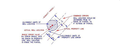
No Scale
Let's look at some more examples...
The Horizontal Component: NAD27 vs NAD83
One of the most common datum-related error sources results from mixing NAD27 and NAD83 horizontal coordinates. NAD27 (North American Datum of 1927) is based on the Clarke Ellipsoid of 1866, (Brinker, Minnick, p. 397) an ellipsoidal model of the earth that is not geocentric, that is, the center of the model doesn't coincide with the center of the earth. For this reason, coordinates derived from the Clarke model do not match geocentric-model coordinates, such as NAD83 (North American Datum of 1983). But while NAD27 and NAD83 match poorly, NAD83 and WGS84 (World Geodetic System of 1984) match very well due to the fact that they are both based on geocentric ellipsoid models (Brinker, Minnick, p. 397). Other horizontal systems that match NAD83 and WGN84 very well (within centimeters) for the vast majority of applications include HPGN (High Precision Geodetic Network) and HARN (High Accuracy Reference Networks). Since much, perhaps most, available spatial data is based on NAD27, it's not easy to avoid it. The bottom line: don't mix NAD27 coordinates with any other kind unless you apply a conversion to align the data. A conversion program is available at the National Geodetic Survey (NGS) site. ( http://www.ngs.noaa.gov/ , then click on "Geodetic Tool Kit", then "NADCON") The following figure illustrates the distribution of NAD27 vs NAD83 differences for the U.S.
EXPECTED HORIZONTAL CHANGE FROM NAD27 TO NAD83
Values in Meters, No Scale
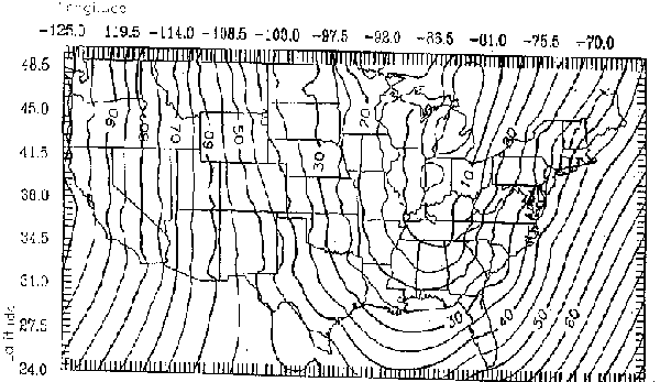
Map Courtesy of Bureau of Land Management
The Vertical Component: NGVD29 vs NAVD88
Just as NAD27 and NAD88 represent old and new horizontal systems, NGVD29 (National Geodetic Vertical Datum of 1929) and NAVD88 (North American Vertical Datum of 1988) are the old and new vertical, or elevation, systems. And as with NAD27, NGVD29 information is everywhere. Most mapping, such as USGS quads and county and city engineering drawings, are based on NGVD29. The conversion between NGVD29 and NAVD88 is not consistent across the U.S. In the central California area, the difference between the two datums is 2' to 3' (Bureau of Land Management, p.3-3), which may be an acceptable accuracy for many GIS projects. For projects that require an accurate combination of data sets from the two datums, NGS has a conversion available at: http://www.ngs.noaa.gov/ , then click on "Geodetic Tool Kit", then "VERTCON". Following is a map illustrating the expected vertical change from NAVD88 to NGVD29:
EXPECTED VERTICAL CHANGE FROM NAVD88 TO NGVD29
Values in Feet, No Scale
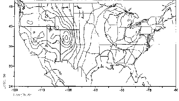
Map Courtesy of Bureau of Land Management
The Temporal Component: Earth in Motion 
Californians are acutely aware of the series of fault lines running the length of the state, and the frequent earthquakes they produce. These fault lines represent the junction of the North American and Pacific plates, which experience two types of movement: secular (slow, normal) and episodic (earthquake). While no one can accurately predict the movement that will result from an earthquake, the secular movement has been modeled, making it possible to calculate displacement between survey control stations using HTDP software (Horizontal Time-Dependent Positioning). For all but a very few GIS practitioners, secular plate movement, at about 5cm per year (D'Onofrio), can probably be ignored.
If it is safe to ignore horizontal motion, is it also safe to ignore vertical movement? For GIS projects relying on vertical accuracy in the moderate to fine range, some consideration if this issue may be required due to ground subsidence and uplift. Uplift is primarily caused by magma intrusion and is seen mostly in the Mammoth Lakes area (D'Onofrio). Subsidence, the physical sinking of the earth's surface, is a continuing phenomenon in many parts world. Caused primarily by human activity such as extraction of petroleum and water, subsidence has impacted portions of California's topography in amounts ranging from about 4 feet near the City of Davis to 29 feet in portions of the San Joaquin Valley (Leake). A combination of old and new topography won't work very well here. In the photo, Joe Poland shows subsidence at a location about 10 miles southwest of Mendota, California. The sign reads, "San Joaquin Valley California, BM S661, Subsidence 9M, 1925-1977". (USGS)
So, How long is a Foot, Exactly?
Effective July 1, 1959 the U.S. National Bureau of Standards, as part of an international effort to standardize units of measure, announced that the customary length of one foot would thenceforth be equal to 30.48 centimeters (F.R. Doc. 59-5442) This value varies slightly from the previous value of 30.480061 centimeters, which had been used for plane and geodetic surveys since its adoption in 1893. Because land surveying often involves the use of coordinate values of several significant figures, such as state plane coordinates, the switch to the new standard would have introduced unacceptable errors requiring constant conversions between existing data and new survey work.
To avoid this scenario the Bureau, in the same announcement, allowed the continued use of the previous value, referring to it as the "U.S. Survey Foot". Note the term "allowed". The International Foot may be used in certain circumstances. The difference between the two measures? Two parts per million, or about 1/8 inch per mile. Negligible!...usually. But if you ever have a project requiring the combination of California state plane coordinates (U.S. Survey Feet) with Arizona coordinates (International Feet), you'll know where the approximately 15-feet of error is coming from! (Evans)
Conclusion
For projects covering large areas most, or all, of the above factors will be inconsequential. This does not mean, however, that the GIS practitioner should neglect to consider them. In order to maintain the integrity of a GIS, the practitioner must be aware of all potential problems so that proper decisions can be made as to which of these factors in fact can be ignored for a particular project. As the use of GIS technology becomes more widespread, the computing power of systems more powerful and the resolution of imaging more refined, the demand for more precise spatial products will increase. And as the demand for more precise GIS solutions mounts, factors such as those discussed above will become increasingly more relevant.
References
Brinker, Russell and Minnick, Roy. The Surveying Handbook. New York: Van Nostrand Reinhold, 1987
D'Onofrio, Don. "GPS: Issues and Perspectives" California Land Surveyors Association. Sacramento, 6 June 1996
Evans, Jeremy. "Getting the Most out of Least Squares" California Land Surveyors Association. Sacramento, October 2000
Leake, S.A. "Land Subsidence From Gound-Water Pumping" http://geochange.er.usgs.gov/sw/changes/anthropogenic/subsid
U.S. Bureau of Land Management. National Integrated Land System, Concept of Operations and User Requirements Washington, March 2000
U.S. Bureau of Standards. Refinement of Values for the Yard and the Pound Federal Register Document 59-5442, 30 June 1989
USGS "USGS Professional Paper 1401-A, "Ground water in the Central Valley, California- A summary report" 1977
|