|
Abstract
Geologic and geographic information along two popular hiking trails in the Lake
Tahoe Basin of California was collected and
analyzed. The purpose of the collection and analysis effort was
to determine the suitability of a basic geographic positioning system (GPS) unit
and a geographic information system (GIS) for providing geologic information to
non-geologists in a more understandable form than is typically available. The
result of the information collection in the field with GPS and camera, storage
with GPS and GIS, retrieval with GIS, and presentation with GIS and graphics
software is that basic GPS and GIS offer excellent capabilities for the
project task. It was also evident that the GPS and GIS tools that were used offer
capabilities for more extensive and more detailed mapping and information
analysis than was tested in this effort.
Introduction
Geologic mapping has been performed in
California for more than 100 years. Over that period, much of the state has been mapped for
mineral deposits, for
locations of faults that may be active, for potential hazards like landslides, or for
general geologic understanding. The result of that work is a quilt of maps at various
scales that have diverse objectives and purposes. In many cases, the geologic entities were plotted on topographic maps by dead
reckoning with Brunton
compass and plane table and alidade, and later with aerial photos and Landsat images.
Accuracy, complexity, and
quality vary among them. The introduction and growth in the use of GPS equipment
during mapping will add accuracy and standardization to the geologic database. The
availability and adoption of GIS and analytical software by geologists is allowing a
wide range of geologic
attributes to be captured in the field, stored electronically, and introduced when needed
for interpretation and
understanding. Converting all of California geology to GIS will take a number of years.
During that effort, the people
of California would benefit if data collection accommodates their needs and interests.
Understanding of the geologic history, geologic present, and geologic future is important
to a large number of Californians and visitors. Rock hounds, hikers, climbers, campers,
and other off-road
travelers who have an interest in the rocks and landforms they clamber over. Land owners
and lessors may not know about
faults or points of geologic interest that are on or near their parcels. There are several
books and field guides on geology that can be viewed along highways written for non-geologists.
However, maps of geology for many trails,
national forest lands, and even
most state parks are not
readily obtainable and, if obtainable, are difficult to decipher for the non-geologist.
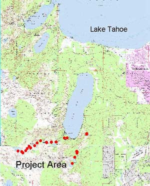
To begin increasing the understanding of geology for the non-geologist, the project
included developing a GIS for two popular hiking trails near Fallen Leaf Lake, southwest of
Lake Tahoe. The project area in shown in
Figure
1 below right.
Geology was based on previous mapping, and no
new geologic mapping was done. A
Garmin GPS 12XL Personal Navigator ® (G12XL)
unit was used to used to record locations of
geologic rock
types, faults,
landforms, the trail route, and photo locations. The following were performed
for the project:
- Trail route marked on
portions of the Emerald Bay and Echo Lake USGS 7.5 minute quadrangle
maps;
- Locations of geology entities
including landforms, faults, and geologic rock features of
interest;
- Close up photographs
of geologic features along the trail;
- "Landscape photos" showing
landforms or other points of geologic interest along the
trail; and
- Explanatory notes and
observations for the non-geologist.
Background
Use of GIS and GPS tools in geologic mapping is not a
new concept (for
example, see Wahl and others, 1995). Maps and books that make geologic features
more accessible and "available" to the none geologist have also been
produced (for example, Alt and Hyndman, 1975). However, the roadside geology
books haven't been expanded to places where rock hounds, amateur miners, weekend
geoscientists, or vacationers take time to stop and understand what they are
seeing. With the exception of some excellent geologic maps of national parks or
monuments, geology that is directed to the non-geologist is not widely
available, and people are interested in geologic phenomena near them, such as,
earthquake fault zones, active volcanoes, and landslides. A number of trails
popular with vacationers occur within a few miles of Lake Tahoe. Because of
their popularity and accessibility, the trail to the Glen Alpine historical site
and the Angora Lakes trail originating near the south end of Fallen Leaf Lake
(Figure 1) were selected for test mapping. Topographic map coverage on 1:24000
(7.5 minute quadrangle scale) of the trail areas was available, and the geology of the area had
been thoroughly mapped (Loomis, 1983)./P>
Methods
Waypoints were collected along the
two trails selected. Waypoint data, collected and stored in the G12XL, were referenced to
the North American Datum (NAD) 27. This datum was
selected
for waypoints because the trails were to be plotted on images of US Geological Survey
7.5 minute quadrangle maps, which were based on the NAD 27 datum. At
each waypoint location, measurements from satellites were averaged over 60 to
120 seconds before recording the coordinates. Trackpoint data were
automatically
collected and stored by the GPS for the Glen Alpine Trail, the northern of the two trails
selected for the project. No trackpoint data were collected for the southern trail.
The waypoint and trackpoint data were downloaded from the G12XL with Waypoints+©
(Hildebrand,
2000). The waypoint data had not been subjected to differential correction, and it was a
secondary
issue in this project to determine if uncorrected data had adequate accuracy for the purpose
of this project. To test the accuracy of uncorrected waypoints coordinates, the waypoints
shape file
was evaluated as a theme with topographic maps a gif images as additional themes.
In ArcView Version 3.2a, the downloaded waypoints and trackpoints were converted to shape
files and opened as views in ArcView.
When shape file were created, database files with ArcView point, identifier, and
attribute fields were created in dbf format. Twenty-six numbered
waypoints are shown with +
symbols in Figure 2.
Figure 2

At each of the
waypoint locations notes on the geology were collected, and a photograph of a
geologic feature or a "landscape" of geologic landforms was taken to
aid the user in understanding the geology along the trail. The geologic notes
and files names for jpg images were added in Descript and Photo
fields that were added to the database created for the waypoints and their
attributes. The file names with jpg extensions in the Photo
field of the database are digital photo images obtained at the waypoint. Note
that the actual date and time in UTC that the waypoint data were collected also
occupy fields in the database. Figure 3 below is a screen view of the database
file created in ArcView.
Figure 3

The last step of the method to
produce a
readily understandable geologic map is to add geologic information from previous
mapping of the area of the trails. Addition of of geologic information was done
for this project by scanning the existing geologic map (Loomis, 1983) and
transferring geologic information from the map to the trail area map file. For this
project, the portion of the geologic map over the area of the two trails was
scanned and digitally stored as a file in gif format. Information
from the file, for example, fault lines and contacts between rock types, were
added to a gif image of waypoints and trails developed in ArcView.
Information was added to the waypoints image from a shape file exported in gif
to Adobe Photoshop®. A draft example of the image with some geologic
information added is included here. It is a work in progress.
Analysis
The
analysis of the project results consisted of: 1. comparison of waypoint and
trackpoint plotted locations with the landmarks on topographic map of the trail
area; and 2. evaluation of the suitability of GIS and GPS for collecting and
preparing the geologic information from the trails for use by non-geologists.
The first analysis was performed in part with an ArcView view shown in Figure 2.
In that figure, all of the waypoints were position data were collected during
the project are shown with the themes of the Emerald Bay and Echo Peak 7.5'
quadrangles introduced as georeferenced gif files, which were obtained
from the Teale Data Center ftp site. In comparing the locations of waypoints to
landmarks on the map, the view in Figure 2 indicated that waypoint locations
plotted on the maps within approximately 15 meters (50 feet) of the locations in the
field where
measurements were made and photos were taken. In a few locations the waypoint
location is obviously inaccurate, for example, location 10 on the west side of
the figure, because the waypoint measurement was made on shore, not in Grass
Lake. However, the accuracy of the waypoints relative to the topographic maps is
considered adequate for the preparation of basic geologic and photo files along
established trails. The geologic features being mapped are of a scale large
enough that an horizontal error of +/-15 meters will not cause the GIS data to
be unusable. Furthermore, the mapping addressed in this project is expected to
conducted on established trails, and therefore, the waypoints are not intended
to be the only indicators of location in the field.
A second analysis was
performed with trackpoint data collected with the G12XL
in the field and then loaded as a shape file in ArcView through the use of the
AVGarmin© tool
(Hildebrand, 2000). The track data were collected at 60 second intervals
automatically by the G12XL GPS unit but only for the Glen Alpine trail. The
analysis performed was a comparison of the track created by the trackpoints with
the path of the trail on the map. Although the entire trail length is not
evident on the quadrangle images, the course of the trail on the map is readily
estimated from topography. The result of the plotting of the tracks from the
Glen Alpine trail are shown in Figure 4.
Figure 4
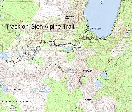
Analysis of the trackpoints downloaded and converted to a shape file
indicated the average level of accuracy of the measurements obtained with the
G12XL and the ability to show an entire trail on a gif figure with
topography and road information. The thin black line that connects the waypoints
represents the path
of the GPS unit followed along the trail in the hand of the geologist.
It is notable in Figure 4 that short excursions
off of the trail to examine rocks or other features are also recorded. The
result of the analysis of the track plotting in ArcView is that the track
function is a useful additional feature for mapping the actual path of the
trail. By comparison with the un-tracked path of the Angora Lakes trail on the
east side of Figure 4, the track stored as points in a GIS shape file would also be an
advantage in compiling geology along a trail and having the ability to plot on a topographic
map the path of an excursion off of a marked trail. The track plot also allows the user to
determine elevations along the course of the trail greater ease.
The second component of the analysis of the collected information indicated that
a GIS (like ArcView 3.2a or a comparable product) and a
twelve-channel GPS unit (like the G12XL or comparable instrument) are
excellent basic tools for collecting data for the geologic maps along trails.
The full capabilities of the GIS and GPS were not tested in this project.
However, it seems evident that the G12XL would provide location data (both
waypoint and trackpoint) of adequate accuracy that it could be used for geologic
mapping of larger, unmapped areas. The database component of a GIS is also
clearly beneficial to mapping, recording, and later plotting of additional
geologic attributes in various views. Those capabilities are a an advantage to
data interpretation for any size geologic mapping project because they enhance
data management.
Observations
Observations from this project were obtained from the
analysis of the
collected data in GIS, from the act of collecting and recording the data,
and the act of preparing the data for presentation. The observations are:
-
A GPS unit (like the Garmin 12XL)
and a GIS (like ArcView 3.2a) are basic,
and yet powerful, tools for preparing maps for non-geologists, but they can
readily be extended to more technical and detailed geologic mapping.
-
The database component of
the GIS provides an excellent tool for
geologic data management; for both numerical and text data related to points
in the field, the database provides a framework for orderly storage,
retrieval, and plotting of geologic information that is accurately located.
Figure 5 is a rough draft image of
the GIS views of
the trails with geologic information added. It illustrates fault lines and other
geologic information obtained from previous geologic mapping (Loomis, 1983). The
reader will note that different symbols have been added at waypoint locations on
Figure 5. When completed in html format, the red symbols on the map image will provide
links to photos, which were taken at the waypoints and are stored as jpg
files with the image.
Figure 5

References
Alt, D.D., and D.W.
Hyndman,1975. Roadside Geology of Northern California. Missoula, Montana:
Mountain Press Publishing.
Hildebrand, B., 2000.Waypoint+ ©.
http://www.tapr.org/~kh2z/Waypoint/
Loomis, Alden
A., 1983. Geology of the Fallen Leaf Lake 15' Quadrangle, El Dorado County,
California, Map Sheet 32. California Division of Mines and Geology.
Wahl, T.E., J.D. Miller, and E.J. Bauer, 1995. Bedrock geologic
mapping using ArcInfo. Proceedings of ESRI Users Conference, p. 167.
|