Abstract
Elevated levels of the insecticide ‘diazinon’ have been detected in water
samples collected from Arcade Creek in northern Sacramento County, California. The
Central Valley Regional Water Quality Control Board (CVRWQCB) is required to identify
sources of the diazinon that enter the urban creek. Using a Geographic
Information System (GIS), coverages and methods developed in this project, subsheds
(storm drain sheds) within the Arcade Creek watershed were associated with their
percentages of each generalized land use type that occurs within each shed. The
sheds that contain the maximum percentage (as a percentage of the total shed
area) of each generalized land use type were identified. The sheds that contain
the maximum percentage of each generalized land use type might be considered
for water sampling locations. These locations might typify the relative amount
of diazinon carried in runoff from associated shed area and the predominant
land use type within the shed area. Possible water sampling sites can be
further evaluated by viewing (using a GIS) local land use types (by parcel) and
storm drain features for a given shed area for creek and drain discharge
locations, access, and neighborhood make-up.
Introduction
This project was performed to fulfill two objectives:
1.
As a project requirement for a Fall 2000 GIS class at American
River College (Geography 26: “Data Acquisition in GIS”, instructed by Paul
Veisze); and,
2.
As part of the effort by the CVRWQCB to develop a TMDL for
diazinon in Arcade Creek, Sacramento County, California.
The purpose of this project was to develop a GIS method to
identify diazinon sources to Arcade Creek. This project determined the mix of
land use types within storm drain sheds within the Arcade Creek, Sacramento
County watershed. Since point sources (e.g., discharge from a pipe at an
industrial facility) of diazinon in Arcade Creek are not known to occur, it is
believed that nonpoint sources (e.g., surface runoff from household
applications of the pesticide) are linked to the diazinon found in Arcade
Creek. Thus, an indirect means must be used to identify and evaluate nonpoint
sources of diazinon use in the Arcade Creek watershed before the CVRWQCB can
develop a Total Maximum Daily Load (TMDL) and associated implementation plans.
It is possible that certain land uses have a higher (or lower) potential for
yielding diazinon residues to Arcade Creek. By evaluating the mix of land use
types within Arcade Creek storm drain sheds, a testable hypothesis may be
formed to help identify the sources for diazinon detected in the creek.
Background
Many pesticides, including the organophosphorous insecticide
‘diazinon’, are used in and around the urban environment for domestic and
agricultural pest control. Diazinon has been detected in water samples
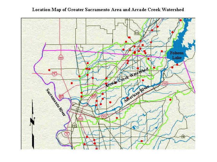
collected from Arcade Creek, located in northern Sacramento County, California.
The levels of diazinon detected in Arcade Creek exceed regulatory criteria and
impair, or threaten to impair, some beneficial uses (e.g., aquatic life)
associated with the creek.
The US Environmental Protection Agency (US EPA) requires a TMDL
for the pollutant or stressor that impairs, or threatens to impair, the
beneficial uses of water bodies. The California State Water Resources Control
Board (SWRCB) has the responsibility of listing and developing TMDLs for
303(d)-listed water bodies in the state. Through the US EPA’s Clean Water Act
[CWA, section 303(d)] listing process, the SWRCB listed Arcade Creek as an
impaired water body for diazinon. The Central Valley Regional Water Quality
Control Board (CVRWQCB) has been given the responsibility for developing the
TMDL for diazinon in Arcade Creek.
A TMDL has several components including:
n
A discussion of the link (method by which a
pollutant/stressor enters and impairs the associated water body);
n
Identification of the source of the pollutant
[including point (e.g., an industrial plant that discharges chemicals into the
water body) and nonpoint (e.g., surface water runoff from lawns, building
foundations, or fields where chemicals have been applied)];
n
A numerical value for the highest level (TMDL) of total
pollutant that can be discharged into, and assimilated by, the water body; and,
n
An implementation plan describing control and
monitoring measures that can be used to achieve the numerical TMDL.
As part of the TMDL development process, the link(s) and
source(s) for the diazinon found in Arcade Creek must be identified. The
sources for diazinon that reach an urban creek include home, small business,
restaurant, and lawn applications of diazinon-containing products. Several
possible links between the sources (points of application) of diazinon usage
and urban creeks include: surface runoff directly into creeks or via storm
drains that discharge into creeks; leaching into groundwater and subsequent
discharge of the diazinon-laden groundwater into a creek; and volatization into
the air and deposition into (or near) a creek (Schueler, 1995). Another
potential link and source is ‘drift’ (diazinon-containing airborne mist or
particulates) from agricultural applications, particularly from air
applications to crops. These sources are considered to be ‘nonpoint’ since they
potentially occur over a widespread area. It is infeasible to find and control
every nonpoint source for diazinon.
Any individual user (homeowner, renter, restaurant owner, etc.) can purchase
diazinon-containing products from the gardening sections of various retail
(e.g., gardening, hardware, home improvement) stores. Although over-the-counter
pesticide products containing diazinon have explicit and detailed instructions
and restrictions for application, there is no way to verify that these products
are always used as specified by their labels. Enforcement of the label
directions and restrictions is impossible for every individual user. Individual
users can purchase, apply, and dispose of diazinon-containing pesticides as
they choose. Thus, this projects attempts to develop a method using GIS to evaluate
an indirect link between urban sources of diazinon use and diazinon levels
detected in Arcade Creek.
Methods
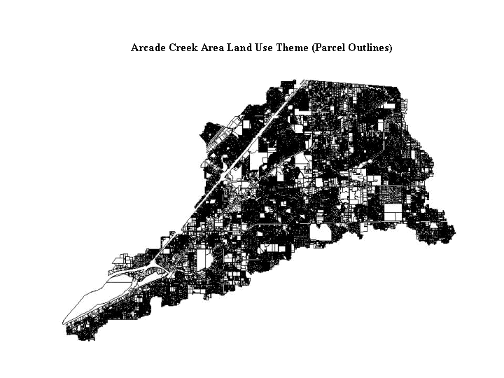
This project used ArcView GIS to separate a coverage showing
the Sacramento County assessor’s parcel land use map by another coverage
showing the Sacramento County assessor’s storm drain shed areas within the
Arcade Creek watershed. The author contacted Sacramento County personnel for
storm drain and land use coverages usable in a GIS. The author searched the Internet
for additional data and pertinent journal articles based on combinations of the
following keywords: urban, diazinon, land use, Arcade Creek, storm water, GIS,
pesticides, runoff, and others. Although the searches returned a large number
of results, very few are pertinent to this project (e.g., Meyer et al, 1993;
Schloss and Rubin, 1992) and only a couple of these articles are available
through the Internet. Since this project is essentially a research attempt to develop
a method to evaluate the potential for linking diazinon use in the urban
environment to land use types, the dearth of relevant articles is not
considered a setback.
Land use data was obtained for free from the Sacramento
County Engineering Department in shape file format. The shape file was
reportedly in (California) State Plane Zone II coordinates, using the NAD 83
datum, and in ‘foot’ units. A Sacramento County GIS technician who qualified
each parameter with uncertainty provided the verbal metadata. While attempting
to use the land use shape file with other well-documented coverages, it became
evident that the metadata provided for the land use shape file was incorrect. The
author determined the correct datum to be NAD 1927.
The land use shape file shows (and has an associated
attribute table for) every parcel in the northern portion of Sacramento County.
The tabular data lists a 6-digit alphanumeric land use code and the area (in
square meters, m2) for each parcel. Other attributes (including
zoning) included with the tabular parcel data was not used for this project.
Section 13-14 (24 pages) of an Operation Manual (County of Sacramento, 1995)
provided with the land use data describes the six-digit land use coding scheme.
Drawings of Sacramento County’s storm drain system were
received for free in CAD (DXF and DWG) formats from the Engineering Division of
Sacramento County’s Office of Assessor. After working directly with a
Sacramento County engineer responsible for maintaining the CAD drawings, a second
set of files was obtained. The drawings in the second set of files were more
easily separable into individual layers for storm drain shed (area) outlines
and labels, storm drain piping networks within each area, and for Arcade Creek
and its major tributaries (into which the storm drains discharge) using ArcView
GIS. The CAD drawings were used to produce shape files in a GIS of Arcade Creek
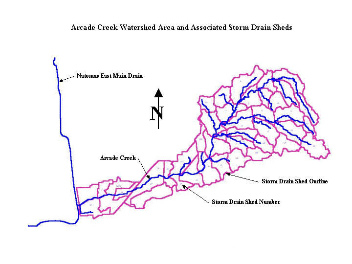
(and its major tributaries) and of 37 storm drain shed areas. Storm drain
system details are intermittently field mapped and revised on paper map copies
the Sacramento County repair crews. The field maps are at a scale of 1 inch =
200 feet (1:2,400).
Since the storm drain maps were based on the land use maps,
the storm drain CAD drawings accurately overlay the land use maps. The storm
drain piping details coverage does not extend westward of US 80, therefore, storm
drain shed areas and associated land use data west of US 80 were not used in
this project. Using the ‘Select by Theme’ option in ArcView GIS, the 37 storm
drain shed areas were used to parse the northern Sacramento County land use
data into 37 separate shape files and associated attribute tables.
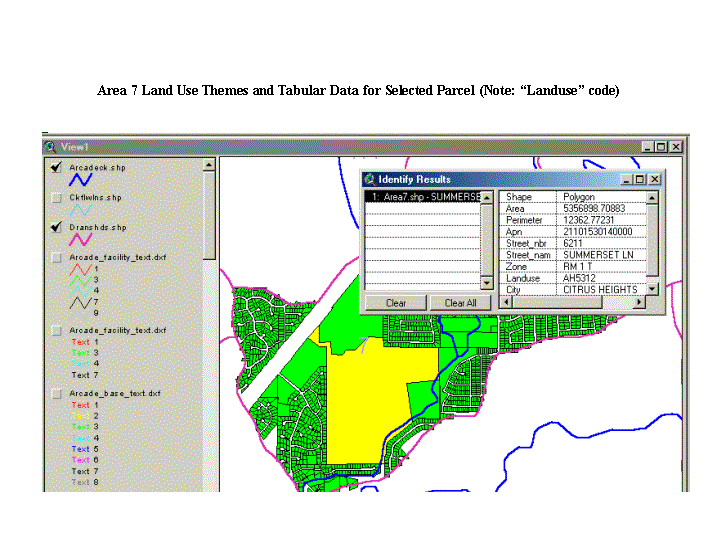
Each attribute file associated with a given (storm drain)
shed area was edited in the GIS to hide all but the areas (in m2)
and land use codes. The edited land use attribute files were opened into an
Excel spreadsheet. The area of each parcel (record) was converted into square
kilometers (km2). The six-digit land use codes were abbreviated
(generalized) to only their first two characters. The resulting 72 land use
types were associated with their descriptions in the Operation Manual (e.g.,
‘A1’ = ‘Residential dwelling unit; single family’; ‘A2’ = ‘Residential dwelling
unit; two family’; ‘AH’ = ‘Residential dwelling unit; mobile home park’).
For each of the 37 storm drain sheds, the area of each
generalized land use type was sorted and subtotaled. The percent of each
generalized land use type (based on the area, in km2 relative to the
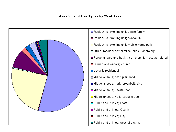
total area of the given storm drain shed) was plotted on a pie chart. The pie
charts allowed the generalized land use type make-up of the 37 sheds to be
visually compared.
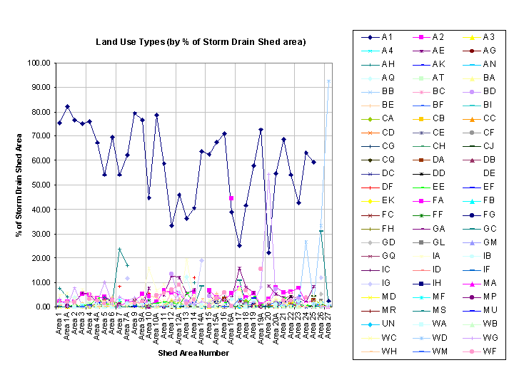
The percent of each generalized land use type for each storm
drain shed was placed into another spreadsheet. Percent of land use values for
each of the 72 generalized land use types that occurred within the 37 storm
drain sheds were plotted on a line graph.
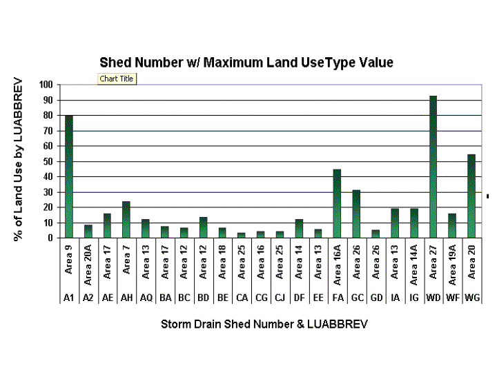
Minimum, average, and maximum values (by percent of area)
were calculated. The maximum values associated with selected generalized land
use type areas were highlighted and plotted on two bar graphs. One bar graph,
sorted by highest-to-lowest maximum generalized land use type areas (in
percent), shows the relative range of the values. The other bar graph, sorted
alphabetically by generalized land use type area (in percent), shows the
grouping of values by even more-generalized land use type (e.g., for all residential
types).
Results
Selected generalized land use types (code and descriptions) and their
associated values and shed area numbers are shown in the table below.
|
Generalized Land
Use Type Code
|
Generalized Land Use Type Description
|
Maximum Percent
of Shed Area
|
Associated Shed
Area Number
|
|
A1
|
|
Residential
dwelling unit; single family
|
|
79.38
|
9
|
|
A2
|
|
Residential
dwelling unit; two family
|
|
8.20
|
20A
|
|
AE
|
|
Residential
dwelling unit; low rise apartment
|
|
16.03
|
17
|
|
AH
|
|
Residential
dwelling unit; mobile home park
|
|
23.71
|
7
|
|
AQ
|
|
Residential
dwelling unit; common area (condo/PUC)
|
|
12.23
|
13
|
|
BA
|
|
Retail-commercial;
small retail
|
|
7.56
|
17
|
|
BC
|
|
Retail-commercial;
restaurant
|
|
6.46
|
12
|
|
BD
|
|
Retail-commercial;
large retail
|
|
13.50
|
12
|
|
BE
|
|
Retail-commercial;
used car sales
|
|
6.70
|
18
|
|
CA
|
|
3.15
|
25
|
|
CG
|
|
Office;
medical/dental office, clinic, laboratory
|
|
4.06
|
16
|
|
CJ
|
|
Office;
residential conversion to office
|
|
4.39
|
25
|
|
DF
|
|
Personal care and health; cemetery & mortuary
related
|
|
12.06
|
14
|
|
EE
|
|
Church
and welfare; church
|
|
|
5.61
|
13
|
|
FA
|
|
Recreational;
golf course
|
|
44.52
|
16A
|
|
GC
|
|
31.14
|
26
|
|
GD
|
|
Industrial;
building materials
|
|
5.30
|
26
|
|
IA
|
|
19.24
|
13
|
|
IG
|
|
19.08
|
14A
|
|
WD
|
|
Public
and utilities; City
|
|
|
92.39
|
27
|
|
WF
|
|
Public
and utilities; public school
|
|
15.78
|
19A
|
|
WG
|
|
Public
and utilities; special district
|
|
54.60
|
20
|
Analysis
The summary of maximum generalized land use types (presented above) for the
37 storm drain sheds within the Arcade Creek watershed indicates that the
predominant land use types are public/utilities, residential, and recreational.
Less predominant (overall), but locally significant (> 10%) land uses
include industrial, retail commercial, and personal care & health. Specific
storm drain shed areas can be associated with each maximum generalized land use
type. For example, of the total area for shed 27, over 92% is for City public
and utilities land use. Similarly, of the total area for shed 9, over 79% is
for residential land use. Water samples might be collected and analyzed for
diazinon from storm drains or portions of Arcade Creek or its tributaries that
occur within these two areas. If the sample sites are carefully selected, the
levels of diazinon detected in the samples might represent the relative
potential for the associated generalized land use type to contribute diazinon
to Arcade Creek.
Conclusion
Using a GIS, 37 shed area themes were used to subdivide
Sacramento County land use type data into 37 data files. Each data file was summarized
by the areal extent of up to 72 generalized land use types that were reported
within the Arcade Creek watershed. The relative amount of each generalized land
use type (by percent of each total storm drain shed area) was plotted as a pie
chart for each shed area. The data from the 37 storm drain areas were combined
into another spreadsheet to plot line and bar graphs. The graphs allowed storm
drain sheds to be visually compared for selecting a range of land use types as
potential water sampling locations. Shed areas associated with the maximum
percent of each generalized land use type were identified to be considered for
collecting water samples to typify the runoff associated with the predominant
land use type. Possible water sampling sites could be further defined by
viewing (using a GIS) the storm drain features for a given shed area for creek
and drain discharge locations, access, and neighborhood make-up.
If sampling sites are properly selected, the diazinon levels
may indicate the contribution the associated generalized land use types make to
the load of diazinon within Arcade Creek. Even if land use type cannot be
associated with diazinon levels through this method, the diazinon levels
detected through carefully chosen sampling sites might yield useful information
indicating relative diazinon contributions between the shed areas.
Refinement of the residential land use type may be required
since it is the dominant land use type within the Arcade Creek watershed (and
the 37 storm drain sheds). Further research may use census data (e.g., median
income or other socio-economic metrics) to evaluate whether any of these
factors can be related to diazinon levels detected in Arcade Creek.
Before actual sample locations are determined, the complete
generalized land use type make-up for potential sampling shed areas should be
evaluated and compared. Since residential land use is a major component of most
shed areas, potential sampling locations for other generalized land use types
might be chosen away from the dominating effect of the residential areas. Using
a GIS further with the land use type data used for this project, queries can be
built to display the parcels containing the target generalized land use types
and the storm drain and creek reaches within those areas.
This project highlighted the necessity for accurate metadata
and metadata documentation. More time would have been available to analyze the
results if not for the efforts spent on determining the true datum associated
with the land use shape file.
References
County of Sacramento, Office of the Assessor, 1995. Land Use Codes. Operation
Manual, section 13-14: 1-24.
Meyer, S., Salem, T., and J. Lubordie, 1993. GIS and Urban Storm water
Management. Journal of Water Resources Planning and Management, ASCE,
119(2).
Schloss, J.A. and Fay A. Rubin, 1992. A “Bottom-UP” Approach to GIS
Watershed Analysis. Proceedings of the 1992 GIS/LIS Conference, Nov. 10-12,
1992, San Jose, CA. American Society for Photogrammetry and Remote Sensing,
2:672-679.
Schueler, T, 1995. Urban Pesticides: From the Lawn to the Stream. Watershed
Protection Techniques, 2(1): [1-6 of the article downloaded via the
Internet from the Center for Watershed Protection at www.cwp.org].
|