Benchmarks are a type of geodetic control monument which mark a position
of known elevation. Recreational GPS units display altitude data. Two Garmin
units were compared, the 12XL and the eTrex Summit with its barometric altimeter.
Generalites are difficult to conclude, but the Summit did not perform
better than the12XL under the conditions of this study.
Among the products made by the GARMIN Corporation are recreational GPS units.
One of its newer offerings is the eTrex Summit. Does the Summit offer an improvement
over another popular Garmin GPS unit, the 12XL? The Summit will by compared to
the 12XL by comparing their elevation readings to geodetic monuments
of established values.
"Before mapping can begin, a network of accurately
measured geodetic control points must be defined
on the ground. Geodetic control points
...are the fixed starting points which surveyors,
photogrammetrists, and others use to determine two
or three dimensional positions..".Robinson et al., 1995
These control points are of two broad types, horizontal and vertical.
A United States vertical control network was begun in 1856.
"...In general, these elevation points did not coincide
with the horizontal control network points being determined
by triangulation. Thus, we currently have two control networks-
horizontal and vertical."Robinson et al., 1995
The vertical control network, finished in 1929, is known as the
National Geodetic Vertical Datum of 1929 (NGVD 29).
This is the vertical datum referenced on the USGS topographic maps I have seen,
and is used for marking contour lines.
It has been replaced by NAVD 88 for use in National Geodetic Survey data sheets.
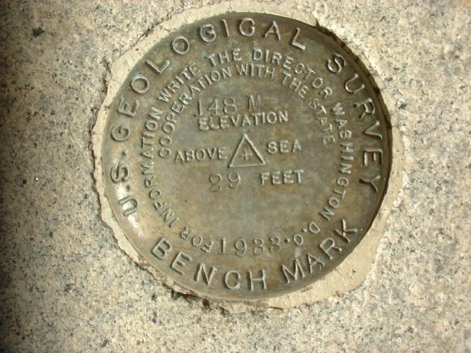
A Bench Mark is a marker, or "monument", often a bronze disc or tablet.
An example is shown at the top of this paper.
It is inscribed with symbols and writing that marks a vertical control point. They are usually
set is concrete or stone, and can be found in a variety of settings, e.g. walls,
railroad abutments, sidewalks.
How does one find a geodetic monument? USGS topo maps contain symbols marking
both horizontal and vertical control points. A brochure explaining topo map symbols
can be obtained from the USGS or, occasionally, from retailers of topo maps.
Unfortunately, the USGS does not maintain lists of monuments or benchmarks.
However, I spoke with personnel in the Denver USGS office who are willing to pull points
and send out a list.
The National Geodetic Survey does maintain lists, which can be searched on the web
at http://www.ngs.noaa.gov/datasheet.html
Data sheets from this site can be downloaded at no cost.
Control monuments are also placed by a variety of entities for numerous purposes.
I used a binder published by the City of Sacramento called the
City of Sacramento Vertical Datum. It establishes a datum using
four USGS & USC&GS monuments in downtown Sacramento. These monuments
are referenced to NGVD 29.The binder can be purchased at the
Customer Service Counter at the City offices on the corner
of 13th & "I" ST in downtown Sacramento.
Up to Table of Contents
Using USGS topo maps, National Geodetic Survey data sheets,
and the City of Sacramento Vertical Datum booklet,
I identified points to recover and planned routes to travel to their locations.
Then I went to a location and tried to find the control monument.
Using the 12XL and the eTrex Summit, I recorded waypoints and
wrote data on field sheets. After returning home, I transcribed and
edited the data on revised field sheets.
USING THE eTREX SUMMIT AND THE 12XL
The Summit offers two possibilities for calibrating the altimeter.
The unit will "...calibrate the altimeter automtically using GPS altitude..."
or it can be calculated "manually" by the user entering either a known
altitude or a known barometric pressure.
In the field, I was inconsistent in manually calibrating the Summit's altimeter.
If I passed by a known Benchmark on the way to my first waypoint
of the day, I would do a calibration. If not, I would wait several
minutes at my first waypoint to let the unit "warm up".To manually calibrate the
unit, I entered the elevation taken off a geodetic monument. Several inches of
clearance was given around the Pressure Sensor Vent.To record
a vertical value, I simply marked a waypoint, and then manually
recorded the data on my Field Notes sheet. I consistently got
adequate satellite coverage with the unit. Where obstructions were present
I chose not to take readings.
With the 12XL I also got good coverage (3D view).
To record a vertical position with the 12XL,
I changed to the Position page to record the altitude. I chose not to take
maximum or minimum altitudes, nor did I use averaging. I simply took the
first figure I saw once I turned to that page. I wrote the data on
my Field Notes sheet.
After returning to the office, the data was manually transcribed from both
units on to a Revised Field Notes sheet.
To see the specifications for either of these GPS units
visit http://www.garmin.com/products/etrexsummit/spec.html for the eTrex Summitt
and
http://www.garmin.com/products/gps12xl/spec.html for the 12XL.
To down load the user manual for the eTrex Summit go to
http://www.garmin.com/products/etrexsummit/manual.html.
To down load the user manual for the 12XL go to
http://www.garmin.com/products/gps12xl/manual.html.
Digital photos for this project were taken with a Fujifilm FinePix 1400 Zoom camera.
Up to Table of Contents

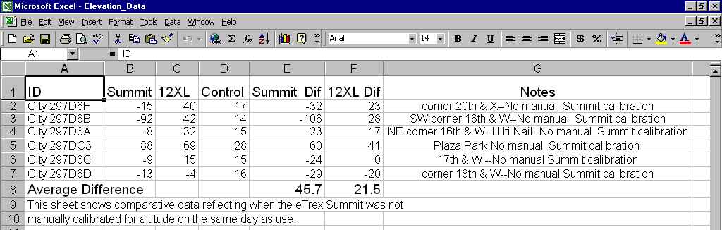
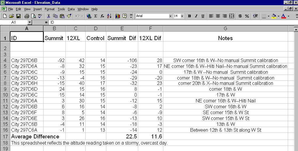
EXPLANATION OF DATA SHEET
The first column gives an ID to the bench mark. Those referenced as "City"
have their ID taken from the City of Sacramento Vertical Datum book
and those identifiers, in turn, are taken from the Thomas Bros. map page
and grid where the benchmark is located. Points identified as "NGS" are
taken from National Geodetic Survey data sheets for the Topo quad within
which the monument can be found(All points published in this
study come fron the "Sacramento Eas" quadrngle.
The numbers in columns B, C, & D represent elevation in feet, rounded either up
or down to the nearest foot. Control elevations were taken from published
data for those points.
Columns E and F give the differences in elevation, in feet, between the GPS
readings and the control elevation. A negative number means that the GPS
unit gave a value under the known value, while a positive number means
that it gave a value over the known value.
The Notes column tells where the monument is in Sacramento and some
calibration information.
The Average Difference is calculated by adding the values for a given unit and
dividing by the number of points used.
DISCUSSION OF RESULTS
- The eTrex Summit gave altitude readings that, in general, were lower than the control
figures. And the 12XL gave readings that usually were higher than the controls.
This was true regardless of the weather or the calibration status.
- Without manual calibration of the eTrex Summit, the 12XL gave more accurate readings.
- During stormy weather, the 12XL gave more accurate readings,
even with manual calibration.
Up to Table of Contents
- COMPARING THE UNITS
A number of factors make comparisons difficult between these two GPS units.
- The number of points actually recovered in this project is relatively small.
Furthermore, the terrain was relatively flat and close to sea level.
Add to that some inconsistencies on the part of the user.
- The user manual for the eTrex Summit states that its accuracy is plus or minus 10 feet...
"Subject to proper user calibration." It further states that ..."For optimum
performance of the Altimeter you should perform the calibration procedure
entering either the correct elevation or barometric pressure." But the manual
doesn't say how often or when to do this. A question to Garmin's e-mail
Help Desk gave the following response:
"It's a good idea to calibrate the altimeter the first time you use the Summit each day.
Calibrating by a known altitude is best; otherwise, use barometric pressure at
mean sea level for your area (usually your local airport can provide this)."
The user manual for the 12XL doesn't state a vertical accuracy, and an e-mail
query gave this answer:
"The vertical accuracy of a 12XL varies between 50 to 150 feet."
- FINDING CONTROL MONUMENTS
Finding control monuments was very time consuming. USGS topo maps
were very problematic. I couldn't find the monuments, or they seemed
to be located in a slightly different location, or they were stuccoed over(?),
etc. The National Geodetic Survey datasheets were much more helpful,
but not without omissions, and several of the monuments listed by them
were not recovered. The City of Sacramento vertical datum gave the most
consistency in terms of there actually being a monument present,
but suffered from using monuments or markers that did not bear a unique ID.
Once a monument was found it may not have been possible to get a GPS
reading. For example, construction scaffolding around the Post Office at
8th and I St. prevented a clear sky view.
- WHICH DATUM TO USE?
The City of Sacramento ties its vertical datum to four monuments in
downtown Sacramento. These are USGS monuments which use NGVD 29
as their reference. On the other hand, the National Geodetic Survey uses NAVD 88
where available, but does include NGVD 29 figures under the
"Superceded Survey Control" section. Neither GPS unit permits selection
of a vertical datum for its calibration or display.This study used the NGVD 29
figures where available. Differences between the two datums is 2-3 feet
Up to Table of Contents
- COMPARING THE TWO UNITS
Generalizing about the relative vertical accuracy of the Garmin eTrex Summit
and the Garmin 12XL isn't justified on the basis of this study. The points
recovered lacked in number, variety, and conditions of use. However, the data
does suggest that the Summit may be less accurate than the 12XL under
certain circumstances, those being stormy weather and failure to manually
calibrate the Summit on the day of use.
- PERSONAL NOTE TO GIS 26 STUDENTS
- My MAIN PROBLEM with this project was lack of a clear problem statement.
I changed course in midstream several times, and did a lot of work for naught.
- I should have done a field test of a small number of Benchmarks prior
to searching for them. As it was, I first poured over topo maps,
planned routes to travel, and researched a lot of points,
and then went in the field, only to discover that a large
percentage of the monuments weren't there.
- The field work was fun but I should have spent more time planning in the office.
I found myself in the field changing plans, revising my Field Notes sheet (which
I never was happy with), and in general wasting time. Carrying around two GPS units,
my clipboard, SPARE BATTERIES AND PENCILS, an umbrella,
and assorted other gear was awkward. Itcould easily have been a two person job.
And if you're collecting points along railroad tracks, watch it!
Up to Table of Contents
- I want to thank the following for help with this project:
- USGS personnel in Denver, Menlo Park, and CSU Sacramento.
Especially helpful was Terry Carr, Cartographic Technician
for the USGS working in the Menlo Park office.
- NGS personnel, espcially Marti Ikehara, Geodetic Advisor with the NGS
and working with the CA Dept. of Transpotation in Sacramento.
- The staff for the City of Sacramento Dept. of Public Works
and especially Roy Heavenston, Supervising Surveyor for the
City of Sacramento.
- The technical support team for the GARMIN Corporation,
which promptly answered e-mail queries regarding their products.
- Using USGS topo maps to locate geodetic monuments is very problematic.
My initial searches for points involved exclusive use of these, and I went
on many wild goose chases. Some were due to a lack of understanding on my part
E.g., I didn't realize bench mark monuments could be placed in vertical aspect
on the walls of buildings. But about half the time the monument just
was'nt there. Why? It seems that monuments on walls are prone to being
stuccoed over or removed when the walls themselves are torn down.
I would often find an X marking a location where I believed a monument
should be. A cartographic technician at the USGS office in Menlo Park
told me that when streets are recurbed, the monument is often lost. He also
told me that the USGS no longer maintains a Field Unit, so checking monument
locations on any kind of regular basis just isn't feasible. I also found
monuments through other sources that were present when the topo maps
were originally made, but that weren't present on the ground. A good
example would be the bench marks at either side entrance to
the Post Office in Sacramento on I ST. between 8th and 9th streets
(which are used by the City as the basis for its datum plane).
- Searching for geodetic monuments can be an excellent source for local history.
For example, the Citrus Heights topo map has a horizontal control mark named
"Swanson". On the NGS datasheet for this mark, PID# JS106, it states that the
monument is" ...on farm land owned by a Mr. A.C. Swanson ..." and that
".. .the route from here will depend on the crops that are being raised at the time...".
While I was at that mark, an old timer walking his dog came up to me and
started chatting. He not only told me something of the history of the Swansons,
but informed me of the presence of another Benchmark on the opposite side
of the street which did not appear on my topo map.
- Walking along railroad tracks is an urban adventure. I recommend it to anyone with time
on their hands and a paid-in-full life insurance policy.
- Click HERE to see that searching for geodetic control
points isn't all work and no play.(Can you spot the Benchmark?)
Up to Table of Contents
Robinson,Arthur H., et al.,(1995).Elements of Cartography pp. 53 and 57.
City of Sacramento Vertical Datum Technical Services Division,
Survey Section, April, 1999.
Garmin Corporation Owner's Manuals
for the GPS 12XL
http://www.garmin.com/products/gps12xl/manual.html
and for the eTrex Summit
http://www.garmin.com/products/etrexsummit/manual.html.
National Geodetic Survey web site--NGS
Up to Table of Contents
|