ABSTRACT
Public participants in
the “saving of the planet” have long been the rallying cry of the organizations
soliciting funds for the continued development of conservation programs. Other
than cash donations, no program has elicited the actually participation of the
common citizen in the process of identification and tracking of individual
sightings of endangered species. This
paper proposes that this type of database can exist and proposes a platform for
accomplishment.
INTRODUCTION
In an age of decreasing Federal and State budgets the public
at large has become an ever increasing vehicle for augmentation of
scientific information gathering and study.
Private companies and educational institutions are
supplementing governmental efforts to develop and populate
biologic databases, gather and store physical data, and facilitate
communications between public and governmental agencies.
“All 50 states and the District of Columbia have some listed endangered
species. Hawaii and California lead
other states in numbers of endangered species designations: Hawaii with 308 and
California with 259. Since 1973, 29
species have been “delisted” or removed from the endangered species list, seven
of those due to extinction.” (1) (This is appalling!)
With the exponential increase in the use of the World Wide
Web information is easier to access and obtain.
Many amateur scientists can now explore the
world around them without the discomfort or inconvenience of
leaving their homes. For those
with a greater sense of curiosity the Internet serves as a
"jumping-off" spot for further exploration. Initial ideas can be explored,
researched, and refined so that individuals can explore
individual tastes and desires to the level of their individual liking.
As opposed to the general thinking of the government, the
public should be welcomed into the research and data gathering process. By utilizing interested and trained citizens
budgets can be managed and valuable data reported and entered into databases
for scientific study. Minimal training
would be necessary to incorporate lay people into the information-gathering
database. All training projects could
be accessible online. Guidelines,
forms, and contact information can all be made available on the Internet. Information management can then be
maintained by professionals at either a clearinghouse or at specific
departments targeted depending on the information obtained.
Utilizing budget monies for populating databases with
information gathered from the public is a more efficient use of funds. Information can then be forwarded to
governmental departments such as the Department of the Interior, U.S. Fish and
Wildlife Service, Marine Fisheries Service, and various Ecological services
throughout the United States and made available for worldwide use. Information can be placed into predetermined
format on an interactive website.
Citizens can enter observations and data transferred from Field
Collection Forms. There can be an area
for transferring scanned graphic images such as photographs to augment
observations. Having this information
available to all interested scientists and lay people in a read only format
allows this data to be copied to project databases and utilized in populating
data fields for informational and decision-making situations.
Utilizing the California Natural Diversity Database as an
example of a database that could be augmented by private citizen observations I
will prove that lay scientists can provide an invaluable “set of eyes” to
further explore the natural environment with minimal additional burden to the
supervising department. This burden
comes in the forms of processing personnel to take the observational data and
format it into useable data within an interim database. Once verification can be done, the data can
then be added to the database as an additional source of location information
for use by various professionals.
Data added to the database can be notated so that persons
using the database will be able to know which data had been generated by the
issuing agency and which data had been provided by outside sources. When professional or lay scientists need to
research a particular plant they can then use both forms of data corroborating
independently gathered data or discounting it, depending upon the direction of
their study.
METHODS
Taking into consideration the above-mentioned database concerns, I proceeded with
research and development of a plan whereby any citizen could act upon desires to help
the environment by adding to the scientific knowledge stored
about a plant species. This information
could be found either upon concentrated effort of a hiking mission to find the
plant, or by accident while on a hike by a prepared trekker.
I began my research by evaluating different sources of
possible links to databases already in existence.
I examined the previous two years issues of GeoTimes,
Geo World, and National Parks magazines.
Unfortunately these proved to be virtually
fruitless. I was unable to find even
the hint of a reference to any project either closely resembling what I was
seeking or a mention of the type of data gathering that I was proposing.
I then proceeded to the World Wide Web.
The Internet proved to be of limited use when researching
data and links that specifically dealt with Natural Resource and Endangered
Species databases in the public sector.
Most of the references that I found were through specific university
projects and most had little to do with Endangered Species at all.
I made the attempt to contact all projects
that seemed remotely in the discipline I was trying to find.
After attempting contact with over 50
various projects and databases; there were no responses to the majority of
e-inquiries sent. In most cases there
was no telephone number for contact and tries to the varied universities
brought no return phone calls. Many of
the databases had not been updated for a period of several years and the
contacts were no longer valid and returned only undeliverable e-mail responses.
There was one exception to the above. The Manzanita Project being administered by
the California Academy of Sciences Library.
Though this project does not specifically deal with Endangered Species
either in the plant or animal variety; it did provide a link to further
development of my idea.
I also contacted the Western Ecological Research Center just
outside the gates of Yosemite National Park.
Jan van Wagtendonk, (PhD) was very helpful and illuminating in his
explanations of the research work going at his facility in the realm of
Endangered and Rare plants within the regions of Mariposa and Tuolumne
counties. When I went to the facility
to speak with Dr. van Wagtendonk he showed me the information gathering equipment,
processing equipment, and analytical data resources used. Currently his primary
assignment is in the area of predictive modeling for fire prevention and
prediction services.
His facility also tracks much of the biodiversity within the
region. He has large volumes of maps
and photographs of plants within the territory that the W.E.R.C. is responsive
to. With the use of sophisticated
Geographic Information Services equipment in the field currently including the
use of a digital camera, and computer processing of images and data available
back at the project headquarters, the Western Ecological Research Center has
built a large library of images and geo-referenced locations for may of the
areas endangered and rare species.
Though many of these resources are not available to the general public,
Dr. vanWagtendonk is very forth coming with information from their studies and
possible areas to examine for specific plant species.
RESULTS
In contacting the California Academy of Sciences, I was
fortunate to receive a response from Carrie Burroughs, staff member of the
Manzanita Project. She informed me; “We
do not have any plans to incorporate other data into our system at this point
in time. It seems slow enough, as it
is, just getting the basic data cataloged for each image.” (Burroughs, 2000).
The images that Ms. Burroughs is referring to are displayed
on the Manzantia Project web site: http://www.calacademy.org/research/library/manzanita/html/.
She went on by saying; “Generally speaking,
photographers that want to contribute to the project donate slides to our
collection so that we then control copyright on those images.” (Burroughs,
2000) The images on the Manzanita Project
website are general photographs of California flora, with an emphasis on
Endangered plants. They invite
photographers to contribute to this “first phase” of the database and provide
basic information of photograph gathering and a list of some 100 species
identified by the State of California and rare or endangered.
On the Project Description page of the website; http://www.calacademy.org/research/library/manzanita/html/discript.htm
the first project goal is described as;
“An initial goal is to create a computer database containing images of
rare, threatened, and endangered plants and animals of California.” (3) The Academy is trying to create a
biodiversity catalog of California’s wildlife for educators, students, and all
interested parties to access. There is
also a list of the Federal listed endangered and rare plants for
examination.
Ms. Burroughs also directed me to CalFlora. This website has pictures of many of the
state’s rarest plant species. The
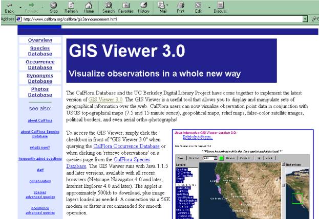
CalFlora site also has instituted a GIS Viewer 3.0 page to help “Visualize observations in a whole new way.” This
website is co-sponsored by the CalFlora database and the UC Berkeley Digital Library Project. They mention that the
GIS Viewer is a useful tool that will display and manipulate sets of
geographical information over the web.
I have included the web page capture below to help you to understand the
layout of the site:

This information makes it possible for enthusiasts to
research their trek before heading out and to better visualize the terrain that they will be accessing when they go in search of the Endangered and Rare plants. These plants are not readily observable and must be carefully tracked in order to insure accurate reporting
of sightings.
Point positions can be gathered and then later researched on
the CalFlora GIS Viewer. This would allow any one with a GPS unit to be able to
provide an accurate position for their find while out hiking.
With the accompanying photograph, this
information could be utilized to provide an invaluable resource for accurate
information gathering.
In Geo World there was one reference to this ability to
utilize field data in the field: “Moreover, the development of palm-sized units
promises an explosion of light, fast and inexpensive data collection tools in
the years ahead" (Jonas, Mark, Hillman, Barry 2000).
The advent of smaller data gathering tools; hand-held GPS units,
Digital cameras, and laptop computers will allow far more accurate information from even the most novice scientist.
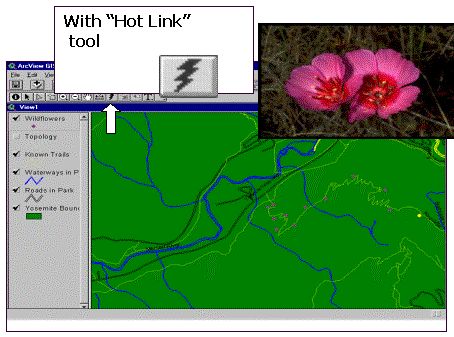
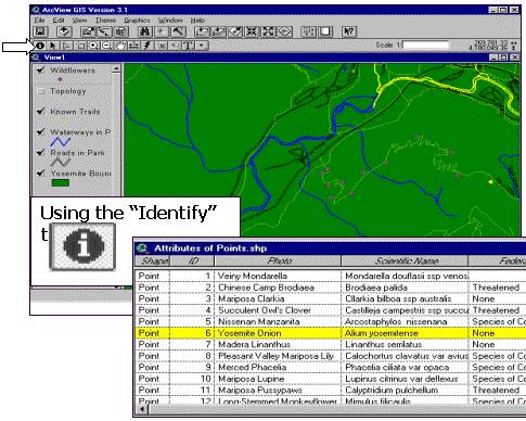
Information can then be displayed using a tool such as ArcView in the
following manner:

By using the tools built into the Arc View program the data gathered could be displayed with either the picture data “Hot Linked” to the theme map as in the above example or by accessing the attribute data by using the “Identify” button as in the example below.

ANALYSIS
Many avenues of exploration were used in the culmination of this project.
Many of them encountered dead-ends. The answers gathered from the
Manzanita Project allowed me to think that the possibility of augmented an
existing database might prove to be a good initial step in the realization of a
publicly augmented natural resource database.
By utilizing the Manzanita Project’s guidelines for picture submission, amateur
photographers and scientists will be able to understand the format needed for
their research to be validated into a research database.
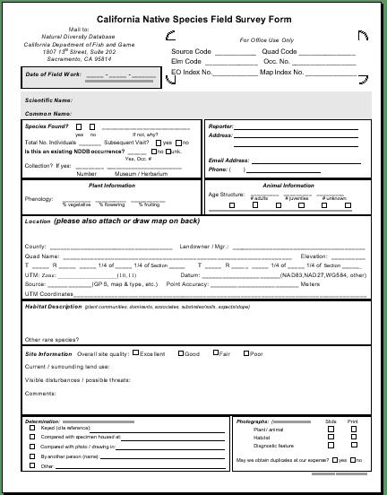
Using a Field Survey Form provided by the CNDDB (California Natural
Diversity Data Base), these same people will be able to understand the nature
and depth of the accompanying data to these photographs. The forms (shown
below) would help in the assurance that correct information was gathered at the
time of encounter, and that the information is as complete as possible. The
example I have used is the Native Species Field Survey form found on the
CNDDB website (4).

By adding these two components together any citizen would have the ability to collect valid, verifiable information that could be examined and used to augment any natural diversity database.
CONCLUSION
Given the difficulties that I encountered with this proposal, easy conclusions did not present themselves. Though enthusiasm for the project has not waned; the size of the task needs to be re-evaluated.
- Coordination of a database populated wholly or in part by non-scientists will need funding – possibly through the grant process.
- Initial building of the database would require substantial effort by grant holders.
- Ongoing support for the database will require repeating the granting process or obtaining sponsorship from a foundation.
The possibility for augmentation into an existing database also exists. This would also require a grant for the initial phases to be able to facilitate meeting with potential candidates to discuss feasibility. Once a partner has been determined, efforts would need to be concentrated in setting up goals for introduction, maintenance and personnel issues for data processing.
After the design and initial implementation phase of the project is completed; the idea could then be revisited and the continued successes evaluated. There would then be quantifiable results tables that would allow decision making on the quantity of the information presented for processing, the accuracy of that information, and the amount of independent corroboration that would be necessary to validate new sightings and instances of plant identification. The
project could also be evaluated for man-hours needed for processing
information based on the responses received during the evaluation period.
All in all this project has the earmarks of allowing citizens to participate in the
recovery of the planet by participating in the cataloging of endangered plants
and sharing of information that will only make the currently available databases
more robust and responsive to the needs of the scientific and governmental
communities alike.
REFERENCES
http://endangered.fws.gov/listdata.html
- On this site you are able to download a variety of information about plants,
animals, and delisted species throughout the United States. There is no place to add information to the
database. This database is current only
through March 31, 1999.
http://www.epa.gov/espp/database.htm
- Again data available for download on a variety of species with instructions
on how to query the database.
http://www.nbii.gov/index.html
- http://www.nbii.gov/datainfo/metadata/
- This second entry was the only one that I found that encouraged you to submit
data of any kind. They were however
looking for metadata, not observational data.
http://www.envirolink.org/species/oesus.html
- A World Species List (WSL), Animals, Plants and Microbes, Established April,
1994, http://www.envirolink.org/species/, USA
Nonprofit 501(c)3, IRS EIN Number 51-0381202, Richard
Stafursky, mavs@panix.com, Lewes, Delaware USA, Voice phone (302) 645-5592 –
This site has an impressive list of data available, down to the microbe level
for download, again, no way to submit data.
http://refuges.fws.gov/NWRSFiles/General/Query.html
- This site is administered by the Fish and Wildlife Service - National
Wildlife Refuge System. There are
instructions for simple search and advanced query techniques for their
databases.
http://darwin.eeb.uconn.edu/biodiversity.html
- This site is mainly interested in listing biodiversity database information
as well as organizations available for research information.
PARENTHETICAL CITATIONS
National Endangered Species Act Reform Coalition, U.S. Fish
and Wildlife Service.
Extracted from: The California Natural Diversity Database –
Commonly Asked Questions (NDDB questions; Answers.wpd//Rev: 1/26/00).
http://www.dfg.ca.gov/whdab/html/cnddb.html
Manzanita Project website, http://www.calacademy.org/research/library/manzanita/html/
|