Abstract
Carnegie State Vehicular Recreation Area (CSVRA) is located near the city of Livermore and managed by the California State Parks, Department of Parks and Recreation, Off-Highway Motor Vehicle Recreation Division (OHMVR). A 2,000 acre piece of land, the Alameda acquisition, will be added to the current park. The purpose of this project was to identify special-status species and sensitive habitats that could represent constraints during future planning efforts for the off-highway vehicle park. The stock ponds located on the acquisition provide habitat for a number of species including two species of special concern, the California tiger salamander (Ambystoma californiense) and the California red-legged frog (Rana aurora draytonii). Based on the locations of California red-legged frogs and California tiger salamanders and their biological needs to survive and reproduce, I recommend closing approximately 8 miles of existing roads and setting aside 847 acres of habitat in which no roads will be constructed and habitat will be enhanced to promote the survival of these two sensitive species.
Introduction
Carnegie State Vehicular Recreation Area (CSVRA) is located near the city of Livermore and managed by the California State Parks, Department of Parks and Recreation, Off-Highway Motor Vehicle Recreation Division (OHMVR). A 2,000 acre piece of land, the Alameda acquisition, will be added to the current park. This new piece is a network of roads and fences as a result of past land use practices, primarily cattle ranching. The Department is mandated by law, through the Public Resources Code, to provide recreational opportunity while conserving the land's soil, wildlife, habitat, and historic values. Park Ecologists are faced with the task of identifying these features and developing a plan to both monitor and conserve them while allowing for recreation.
The purpose of this project was to identify special-status species and sensitive habitats that could represent constraints during future planning efforts for the off-highway vehicle park. Special-status species are plants and animals that are legally protected under state and federal Endangered Species Act or other regulations. In this paper, I used GPS data with ArcView mapping to evaluate spatial relationships between existing roads, wildlife habitats, and locations of sensitive wildlife species. Through the analysis of these relationships, I was able to identify locations where existing roads should be closed and rehabilitated, and places where no trails should ever be located and habitat should be set aside and managed for wildlife values.
Background
The California OHMVR was established in 1971 with goals of acquiring lands to accommodate OHV recreational use, developing facilities to provide for comfortable public accommodations, safe recreational use, and sensitive environmental management of the lands to protect natural resources (OHMVR 1998). The acquisition would meet the goals and objectives of the program by providing recreational opportunities not available at existing facilities, meeting the current and projected needs of OHV enthusiasts, and increasing trail management options to protect natural resources.
The Carnegie SVRA is a 1,540 acre park located in eastern Alameda and western San Jauquin counties in the eastern foothills of the Diablo Mountain Range. The 2,000 acre Alameda acquisition is located adjacent to the park in eastern Alameda County. The elevation of the park ranges from 560 feet in the northeast of the unit to over 1,700 feet in the southwest. CSVRA is located in a rainshadow and has warm, dry summers followed by cool, wet winters (SDSU 1994). Annual temperatures range from 40 degrees Celsius to minus 5 degrees Celsius. The SVRA is primarily used by motorcycles with peak use in late fall through early spring. The Alameda piece would provide recreational opportunities for motorcycles, ATVs, and four wheel drive vehicles, as well as, mountain bikes, horseback riding, hiking, and nature study.
The study area is composed of a mix of annual grassland, oak woodlands, coastal scrub, riparian woodlands, juniper woodlands, and small wetlands. Historically, almost the entire site has been used for livestock grazing, which has resulted in degradation of much of the natural vegetation (EDAW 1997). Although the wetlands (stock ponds) are man made, primarily for cattle grazing, they do provide habitat for a number of species including two species of special concern, the California tiger salamander (Ambystoma californiense) and the California red-legged frog (Rana aurora draytonii) (Jones & Stokes 2000).
The tiger salamander is a candidate species for listing as a federal threatened species (California Department of Fish and Game 1999). Tiger salamander larvae were found in four of the stock ponds in the study area (Jones & Stokes 2000) and have been found in all of the ponds. (Johnson 1980). All fourteen of the stock ponds have been highly degraded from intensive livestock grazing, but they still provide suitable breeding habitat (EDAW 1997). California tiger salamanders are terrestrial and spend most of their time underground in small mammal burrows, emerging for only brief periods to breed in temporary or permanent water sources. OHV use could result in the death of tiger salamanders during migrations between upland habitat and breeding ponds. In addition, tiger salamanders could be killed in their burrows by heavy vehicles (Jones & Stokes 2000). Migration may not have as much of an impact because tiger salamanders are nocturnal and most of the movement occurs during the night when there will be no OHV use.
The red-legged frog is federally listed as threatened and is found on 80% of the ponds (Davidson and Trenham 1998). The Corral Hollow region of the acquisition is one of the few remaining areas within the Central Valley hydrographic basin that supports California red-legged frog (EDAW 1997). Stock ponds within the study area are considered suitable breeding habitat for the frog. During the winter and spring, the frogs could also use seasonal drainages and vegetated uplands near the ponds (EDAW 1997). The acquisition could result in harassment and direct mortality of California red-legged frogs. Restricting riding to trails only, rerouting trails, wet weather closures, and no OHV riding after sunset will help to ensure that impacts are less than significant.
Methods
Data acquisition is necessary for any Geographic Information Systems (GIS) project. I set out to locate all GIS data for Carnegie SVRA and the Alameda acquisition to form a database at the OHMVR headquarters in Sacramento. When I was finished with the data search, I realized I had too much data and too many shapefiles for a semester long class project. I decided to simplify the hypothesis for the acquisition and focus on wildlife species. I wanted to try and determine the significance of the impact of OHV use on sensitive wildlife species.
A detailed habitat-based field assessment conducted by a consulting firm was the primary method used to identify the portions of the study area with potential to support special-status wildlife species and determine potential impact on these species. Data was acquired by consolidating existing information that had been collected by various park ecologists and by a contracted consulting firm. This required conversations with park ecologists, searches through computer files, literature search, and conducting site visits to double check and collaborate the accuracy of the data. General information on habitat types and special-status species present on the site was obtained from a biological analysis previously consucted for the site (EDAW 1997). Literature searches included 1.Biological Constraints Analysis for the Alameda/Tesla OHMVR Project; 2.Carnegie SVRA Habitat Monitoring System Annual Report 1998; and 3.California Department of Parks and Recreation CSVRA General Plan Amendment EIR. Aerial photography had been used in developing several of the shapefiles that I found in the database. The photos were used in compiling vegetation, trails, barren areas, and erosion features. A global positioning system (GPS) Trimble GeoExplorer II was used by the consulting firm to map certain biological features and their respective boundaries. I did not use all of these shapefiles for my final analysis. The data that was used was vector-based. I then created new shapefiles from the existing data for the analysis, such as trails that needed to be rerouted and buffers for wildlife species. I did acquire a very recent raster based image of Carnegie from PSOMAS, but was unable to use it due to a different coordinate system and I did not have time to convert it over to the UTM coordinate system that I was using. Data was mapped using ArcView 3.2 software.
Analysis
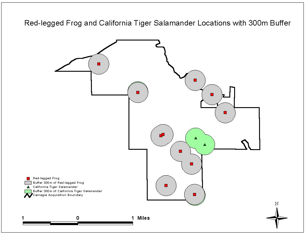
Red-legged frogs do not appear to move large distances from their aquatic habitat and stay within a few jumps of water during the summer, and in the winter and spring stay close by in the drainage and uplands (Jennings and Hayes 1994). Similarly, tiger salamanders stay within the pond or pond margin except during juvenile migration, during which they may travel nocturnally more than a mile (Zeiner et al. 1988). Given these life history strategies, I believe a circle with a 300 meter buffer centered on the pond would provide adequate habitat to allow these species to survive and reproduce in absence of disturbance. I, therefore, set up vehicle closure areas (buffers) around the known locations of these habitats and species.
Conclusion
Based on the locations of California red-legged frogs and California tiger salamanders and their biological needs to survive and reproduce, I recommend closing approximately 8 miles of existing roads and setting aside 847 acres of habitat in which no roads will be constructed and habitat will be enhanced to promote the survival of these two sensitive species. Because the stock ponds are considered one of the most sensitive habitats on the study area, these areas should be given the highest priority for protection for breeding habitat. In addition, these areas need protection due to the potential to be easily damaged by even low levels of disturbance. The California red-legged frog and California tiger salamander would likely benefit from decreased grazing pressure. Future restoration efforts should be focused on rehabilitating shorelines and emergent vegetation along the margins of stock ponds.
The site needs to be actively managed to protect sensitive natural, cultural, and aesthetic resources; control erosion and sediment deposition; control fuel loads; and facilitate the rehabilitation of degraded areas. An adaptive management strategy to limit disturbance to wildlife needs to be adopted for the new acquisition that would use seasonal trail closures, changes in recreational use, and rerouting of trails. I recommend that the CSVRA GIS database be updated annually. The GIS can then become a valuable tool for managing the park and monitoring the impact of human activity on its resources.
Literature Cited
California Department of Fish and Game. 1999. List of Special Animals. Natural Heritage Division, Natural Diversity Data Base. Sacramento, California.
California, State of, Department of Parks and Recreation (CDPR) OHMVR. 1998. Carnegie State Vehicle Recreation Area, Habitat Monitoring System, Annual Report. Sacramento, California.
Davidson, C. and P. Trenham. 1998. Amphibian Surveys: spring 1998 Carnegie SVRA, Final Report Ca. State Parks and Recreation. 32pp.
EDAW. 1997. Biological Constraints Analysis for the Alameda/Tesla Off-Highway Vehicle Project. September 17, 1997. Sacramento, California.
Jennings, M.R. and M.P. Hayes. 1994. Amphibians and Reptile Species of Special Concern in California. Final Report Submitted to the California Department of Fish and Game Inland Fisheries Division. Rancho Cordova, California.
Johnson, D.H. 1980. The Comparison of Use and Availability Measurements for Evaluating Resource Preference. Ecology 61:65-71.
Jones & Stokes Associates. 2000. California Department of Parks and Recreation CSVRA, General Plan Amendment, Environmental Impact Report. Sacramento, California.
San Diego State University. 1994. Carnegie GIS Final Report. Center for Earth Systems Analysis Research, Department of Geography. San Diego, California.
Zeiner, D.C., W.F. Laudenslayer, Jr., and K.E. Mayer. 1988. California’s Wildlife. Volume I. Amphibians and Reptiles. California Statewide Wildlife Habitat Relationships System, California Department of Fish and Game, Sacramento, California.
|