Abstract
The objective of this project is to find how GIS is used in Japan to prepare myself for a GIS job in Japan. The study was conducted using the internet to obtain necessary information. Initially, I have searched private companies utilizing GIS then government-affiliated organizations and cities and prefectures. The companies' websites did not have extensive information about the application of GIS, but national research centers, as well as a city, had more detailed descriptions of GIS application. This project, however, was complicated by difficulty in locating websites and translating the content written in Japanese to English. From the websites that I was able to find I have acquired some knowledge about GIS in Japan. This project also prompted me to a new issue: a need to understand datum, projection and coordinate systems for Japan if I want a GIS job in Japan.
Introduction
The project will investigate how much information is available on the Internet regarding GIS in Japan. The main purpose of this study is for a personal reason to learn about the extent of use of GIS in order to prepare myself for a GIS job in Japan. By conducting this study, I would become more aware of the types of job available in Japan to those who have studied GIS. Since I currently take residence in the U.S., I will limit my search method to the use of the Internet. The search area will include government agencies, organizations and institutions, as well as private sectors, utilizing GIS and their major applications. I hope this research will not only provide better understanding of Japanese GIS myself but be informative to those who are interested as well.
Background
Japan was chosen as the study country since it is my home country and I am planning to go back once I complete my GIS certificate program at ARC. I have been browsing the internet and found some GIS related sites in Japan so I know that there are information available on the web regarding GIS. The sites I have come across range from webpages created by individuals working in GIS field to those provided by national organizations. My current list of Japanese GIS sites, however, is very small. So this project is a good opportunity for me to perform more extensive search to gather more information.
Methods
Several methods were used in this study. First, I thought the most efficient way to learn about GIS use in Japan and find GIS jobs at the same time would be by looking at employment sites. The search engine Yahoo Japan had a employment section and their database can be searched using keywords. 'GIS' was used as a keyword. Secondly, it is unlikely that all organizations working with GIS currently have open GIS positions, so it was necessary to find those organizations by other means. Yahoo Japan also had a category for GIS under business and economy directory. A list of companies with a brief company profile was obtained, but it only included private companies most of which are venders of GIS software. In order to find organizations applying GIS, a Japanese search engine, goo, was used in the third search attempt. Here, keywords "gis" and "application"(in Japanese) were used and search parameters were limited to domains ending with "go.jp", which indicates government-affiliation. In this way the search was able to excluded companies whose address end in co.jp. After this search I realized that GIS may be used at prefecture or city level. So the fourth search utilized another search engine, Infoseek, since it had a directory related to prefectures in Japan. One of the links was a website containing a clickable map of Japan (www.nippon-net.ne.jp/japan.html) that takes you to the homepage of different prefectures and cities within each of the prefecture.
Results
Following results were obtained from Yahoo Japan Employment search. These job listings were posted on the website on October 31, 2000. There were two types of open positions related to GIS: sales and system engineer. The table below summarizes the result showing the name of the company with a brief job description for each position.
| Company Name |
Job Description |
| ASTERIC Corporation |
Sales engineer - Provides various business solutions
regarding database development, CTI system development, building
databases, and development of GIS. |
| OGIS-RI (Osaka Gas Information
System Research Institute Co., Ltd) |
Sales specialist - Provides network solution, user
solution, business solution, technical solution. |
| Thirty Four Systems Co |
System engineer - Develops various types of
application software including GIS related software. |
| Misawa Van Corp. |
GIS engineer - Plan and develop GIS, Geographic Information
Systems, as well as system compatible for ASP, application
service provider, that uses the internet. |
| TG Information Network |
GIS technical development - GIS technical development,
web-based GIS, filing system development, development of
operation system utilizing GIS. |
| Nippon Koken Systems Co., Ltd. |
GIS related operations development technician - Develops operation
AP utilizing GIS engine. Develops map related operation AP utilizing
G-XML. Building Web, or e-business, that includes map information.
|
| OGIS-RI (Osaka Gas Information
System Research Institute Co., Ltd) |
GIS solution engineer - Provides solutions in the fields of: facility
information management, area information management, police and fire
department information management, etc. |
From Yahoo Japan Geographic Information Systems category I was able to obtain a list of companies that were hyperlinked to their websites. I visited each website and located sections containing information about applications of GIS.
| Company Name |
GIS applications |
| GEO |
Real estate/construction, delivery companies, financial institutions such as
banks and insurance companies, manufacturer, others. |
| SECTOR |
City planning, road safety management system, water supply management system,
sewage management system, agricultural land management system, fixed property
management system. |
| Aero Asahi Corporation |
Management systems for varieties of property management systems, planning(such as
for city, agricultural information, health and medical, disaster assistance),
sewage, drinking water, road, park, historical ruins, forestry, and others.
|
| Advanced Core Technologies, Inc |
Road network system that can be used with GIS software. |
| Internet GIS |
Develops systems that allow GIS services through internet sites,
personal navigation system, systems which allow the result of data
analysis to be displayed on maps, and GIS data center to provide
suitable data for different GIS users. |
| Exceed Corporation |
City planning, agriculture/forestry, electricity, road network, marketing,
environmental management. |
| Excel Consultant |
Land register management system and customer management system. |
| NSEngineering |
For local government, management system for public park, fixed property, sewer line,
police and fire department. For utilities and communications, facility management,
safety management, etc. Other application possible in the field of distribution,
health, agriculture, services, finance and insurance. |
| KANAI Co., Ltd. |
Management system for environmental observation stations. |
| KIMOTO Co., Ltd |
Land ownership information management, agricultural land information management. |
| Koyo Giken |
Management system for sewer line, parks, urban planning, and many more. |
| Communication Planning Corporation |
Marketing,member information management, area analysis, customer distribution,
effectiveness of advertisement, managing cables and pipes for underground
construction, real estate |
| SystemTandS |
Forestry information system. |
| JUSTEC Corporation |
Agricultural land management system, sewer line management system, water supply
management system, forest resource management system, city planning support system,
public park management system, and many more application systems. |
| Koyo Giken |
Management system for sewer line, parks, urban planning, and many more. |
|
The third internet search result is from the search engine goo. The search yielded over 300 webpages but not all of them had information I was looking for. So the pages were narrowed down to those that indicated in the page description that it contained information about GIS application.
Hokkaido Institute of Environmental Sciences, Nature Conservation Department
http://www.hokkaido-ies.go.jp/HIESintro/Natural/ShizenHP2/hozen/HOZEN.htm
Natural Environments Conservation Section of this department uses GIS and remote sensing to research ways to protect, manage and assess natural environment. ArcView and Arc/Info are used.
This section of the department presented three research topics that utilize GIS:
- Estimating great spotted woodpecker breeding area. Woodpecker plays an important role in forest ecosystem. They excavate holes on trunks of trees to build nests and later, when those nests are no longer needed, they are used by other little birds and critters in the forest. In this study, a model was created to estimate environmental conditions of breeding site by using data gathered from field survey. Then a forest map was created from a Landsat TM imagery of the study area. The imagery was classified into two categories: forest or not forest. On this forest map, the breeding site model was applied and the resulting map showed the areas of suitable breeding site(Figure 1). The map was also turned into a 3D model which showed areas of high peaks as the most suitable breeding sites(Figure 2). After these analysis were carried out, the researchers went to the locations that were estimated to be the suitable sites and they have actually found the nests of the woodpeckers at those locations.
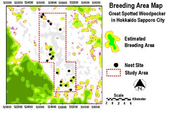 Figure 1. Estimated and actual nest area map.
Source: Hokkaido Institute
ofEnvironmental Sciences, Nature Conservation Department
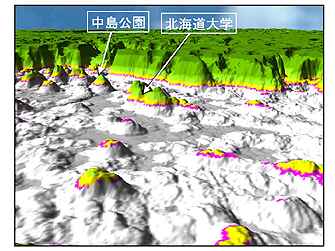 (In this image, left description says Nakajima park, on the right is University of
Hokkaido)
(In this image, left description says Nakajima park, on the right is University of
Hokkaido)
Figure 2. 3D map of suitable breeding sites.
Source: Hokkaido
Institute of Environmental Sciences, Nature Conservation Department
- The Brown bear habitat assessment. Brown bear is one of the species of concern in Hokkaido because its habitat has been fragmented and populations of brown bears in some of the isolated habitats are facing endangerment(http://www.hokkaido-ies.go.jp/HIESintro/Natural/ShizenHP2/SIKA/deerEng/HGeng/HGeng.htm). By analyzing the distribution of the brown bears and factors that affect their habitat, such as terrain, vegetation, and land use, the study tries to determine the home range of the brown bears and method of habitat assessment(Figure 3).
 Figure 3. Source: Hokkaido Institute of Environmental Sciences, Nature Conservation Department
- Forest fragmentation.
This study is concerned with the fragmentation of forest due to a significant
population growth. When a forest becomes fragmented and separated into smaller
forests there are various effects on plants and animals living in the forest. The
following three studies were conducted in Ebetsu city in Hokkaido where the forest
fragmentation has occurred. The purpose of this study was to try to evaluate the
fragmented forest by the effect it has on the following three factors:
- Ground beetle.
Ground beetle is an important secondary predator who makes interior of forests
home. Forest fragmentation, however, creates smaller forests which results in
smaller interior space. The interior space is reduced even further when the size
of those fragmented forests becomes smaller which, to the ground beetles, mean loss of habitat. So, here, the area required for ground beetle habitat is used as
an indicator for the health of the isolated forests. The researchers set the
parameters of healthy forest to be an area greater than 1ha and width greater
than 100m. From all the isolated woods still left in the city, 1174 of them
had the required area. 50m buffer was then created from the edges of the forests
toward the center to determine which forests have width of 100m or greater. Only
about 4%, 44 forests, met both area and width criteria(Figure 4). Thus
when the health of these fragmented forests was evaluated based solely on the
habitat size requirements of ground beetle, the city had a very small percentage of
the forests that can be called healthy.
 Figure 4. Distribution of healthy fragmented forests. Scale in kilometers. Source: Hokkaido Institute of
Environmental Sciences, Nature Conservation Department
Figure 4. Distribution of healthy fragmented forests. Scale in kilometers. Source: Hokkaido Institute of
Environmental Sciences, Nature Conservation Department
- People.
Trees help create a hospitable living environment. A former study
indicated that 13 to 17% of tree areas in 500m x 500m area were required for
people to be at least 50% satisfied. A study was conducted in urbanized areas of
Ebetsu city using those figures to evaluate the nature left in the city. The
result was that the majority of the city had less than 13% of the tree areas and the
only areas that had more than 13% were located adjacent to a forest park and
along the rows of trees next to railroad track(Figure 5).
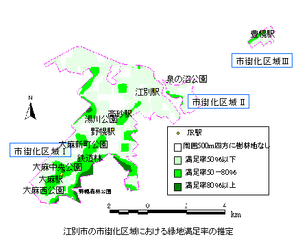 Figure 5. In the legend, yellow dot indicates train station, white area does not contain tree areas within 500m radius, light blue means less than 50% satisfaction, green 50 to 80% satisfaction, dark green greater than 80% satisfaction. Descriptions in boxes bounded by blue lines, from left to right, say area designated for urbanization I, II, and III, respectively. Along the line of green areas are names of train stations and parks. Source: Hokkaido Institute of Environmental Sciences, Nature
Conservation Department
Figure 5. In the legend, yellow dot indicates train station, white area does not contain tree areas within 500m radius, light blue means less than 50% satisfaction, green 50 to 80% satisfaction, dark green greater than 80% satisfaction. Descriptions in boxes bounded by blue lines, from left to right, say area designated for urbanization I, II, and III, respectively. Along the line of green areas are names of train stations and parks. Source: Hokkaido Institute of Environmental Sciences, Nature
Conservation Department
- Distribution of fragmented forest as corridors for plants and animals.
Some of the problems with forest fragmentation are that it limits
biodiversity within each of the fragmented forest, species movement, and
home range of animals that require an extensive habitat. So in order to find
possible corridors that connect the fragmented forests, the researchers performed the following analysis. They assigned low values to wooded area and high values
to the rest of the area so the best corridor is the route with the lowest cost, or value.
They noted that the analysis can be improved by taking more factors into consideration.
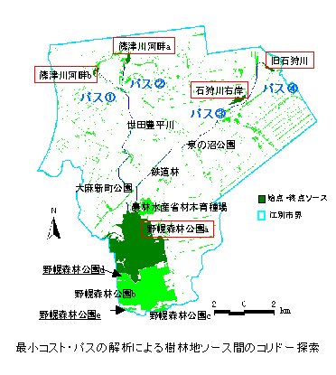 Figure 6. Location of possible corridors. Indicated in blue are path 1, 2, 3 and 4, from left to right. Two green areas at the bottom are forest parks. Source: Hokkaido Institute of Environmental Sciences, Nature
Japan International Research Center for Agricultural Sciences
http://ss.jircas.affrc.go.jp/
http://ss.jircas.affrc.go.jp/pub/yuki/study.html
One of the studies conducted by a researcher at this center concerns land degradation and finding a way to assess this problem. The study focused especially on a type of land degradation called desertification. The study analyzed desertification occurring in the central Australia by taking Landsat/TM imageries of the area to see the change in the abundance of vegetation. The imageries were analyzed with Neural Network algorithm and eventually processed utilizing GIS using map calculator(Figure 7).
They also presented a way to build a database model for viewshed analysis using GIS digital elevation model. The model was applied to determine the visible areas from a ranch located on a plateau. Taking into account such factors as distance, visibility, angle and depth, they were able to determine how much visibility can be obtained from which direction.
 Figure 7. Source: Japan International Research Center for Agricultural Sciences
National Institute for Environmental Studies, Social and Environmental Systems Division, Information Analysis Lab
http://www.nies.go.jp/shakai/index-e.html
The institution conducts environmental analysis at both local and global level. One of the studies conducted at this laboratory utilizes remote sensing. Currently, they are working on monitoring environmental changes in asia-pacific regions by acquiring data through satellites and also trying to find ways to use satellite data for wetlands conservation.
Below is the vegetation distribution in asia-pacific region constructed from satellite imageries.
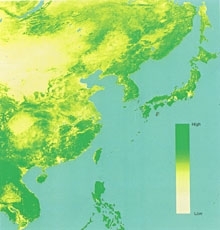 Figure 8. Vegetation distribution in Asis-Pacifics.
Source: National Institute for Environmental Studies
Result from Infoseek
Toyonaka city, Osaka prefecture
http://www.senri-i.or.jp/toyonaka/
The city creates and provides digital maps of the city in several formats including shapefile which was first made available in September 2000. The city is divided into 371 rectangular areas(Figure 9), each covering 300m x 400m area(Figure 10). The maps have scale of 1/500, around 300 data items, and are available to the public for about $100 per map provided in CD-ROM or FD. The city will be updating data on major roads and buildings every year so most current data will be available. Free sample is available to download from the website.
The data provided is very detailed. One of the point theme contains data about buildings. Such features included in this theme are post office, school, museum, library and hospital and each type of building is coded for their identification. Another point theme provides locational information about manholes. These manholes are also coded according to their use, such as gas, water, sewage, electricity, industrial waste water, etc. I downloaded a free sample and, as shown in Figure 11, drew building and road themes.
Metadata was also available on the web. It described quality of the data such as projection, coordinate system, mean sea level, who planned the work and who created the digital maps. The maps were digitized directly from aerial photos taken at altitude of 500m. The type of film used to take the aerial photos were also specified.
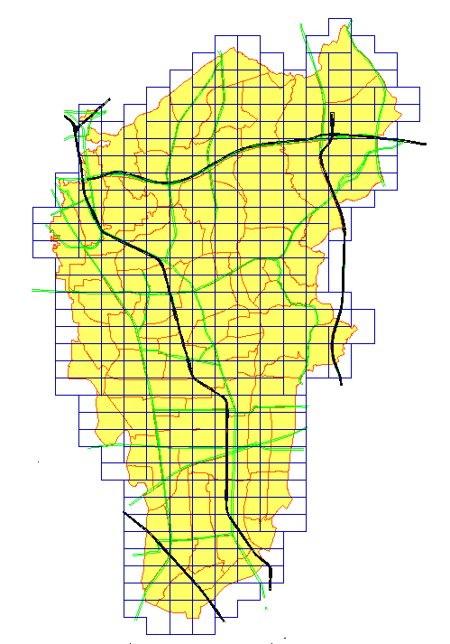 Figure 9. City divided up into 371 map areas.
Source: Toyonaka city, Osaka prefecture
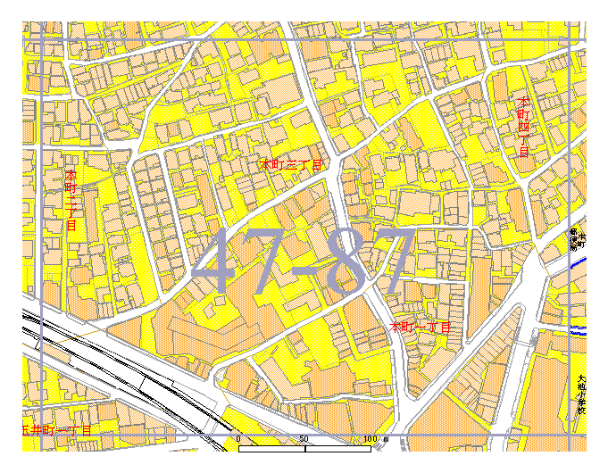 Figure 10. One of the map areas. Only seven of the 300 data items are shown.
Source: Toyonaka city, Osaka prefecture
 Figure 11. Buildings and streets themes displayed in ArcView.
Analysis
The first two searches did not give me the kind of results that interested me. Most of the open GIS positions that I was able to find were with the venders of GIS related software who were interested in hiring programmer, engineer, or marketer and I neither have the experience nor the interest in these lines of work. As for Yahoo's GIS category, I was happy to discover that the site even had a category for GIS. I was able to learn that there are many companies involved in GIS. Majority of the companies are developers of GIS who designs and creates systems specific to different types of application. I have summarized the application types and the corresponding number of companies who offer the products that can be used for those applications(Table 1). Some of the most popular applications included agriculture, city planning, marketing and sewer line management. This summary, however, is not a true representation of GIS companies in Japan since data was obtained from only one search engine.
Table 1. Summary of application types and number of companies developing those softwares
| Application Type |
Number of Companies |
Application Type |
Number of Companies |
| Agriculture(land management, information management) |
6 |
Historical ruins |
2 |
| City planning |
6 |
Land management(registration, ownership) |
2 |
| Marketing (customer management, area analysis, customer distribution,
effectiveness of advertisement) |
6 |
Real estate |
2 |
| Sewer line |
6 |
Utilities (electricity) |
2 |
| Public park management |
5 |
Facility management |
1 |
| Forestry |
4 |
Communications |
1 |
| Road network and safety |
3 |
Construction |
1 |
| Water supply |
3 |
Disaster assistance |
1 |
| Delivery, distribution |
2 |
Manufacturer |
1 |
| Environmental management |
2 |
Member information management |
1 |
| Fixed property management |
2 |
Police/fire department |
1 |
| Health/medical |
2 |
Safety management |
1 |
| Finance(banks, insurance) |
2 |
Service |
1 |
The results obtained by narrowing down the search to government-affiliated organization were more informative in that they conduct researches using GIS and they are explained, in varying detail, on their websites. Hokkaido Institute of Environmental Sciences utilizes GIS for their conservation projects. One of the projects is concerned with assessing habitat for animals that has a key role in the ecosystem of forest such as great spotted woodpecker. Protecting rich wildlife of Hokkaido is also an issue and GIS is used for evaluating habitat for brown bears. The forest itself was observed closely as it has been broken into smaller forests scattered around the city. Some of the impacts of it are analyzed from the insect's viewpoint as well as from people's perspective. All three projects presented on the institution's website have put GIS to good use and were able to produce maps that captured the essence of their problems.
Both Japan International Research Center for Agricultural Sciences(JIRCAS) and National Institute for Environmental Studies(NIES) conducted studies that extended beyond their county. The JIRCAS applied GIS analysis in land degradation problem in Australia, utilizing remote sensing technology for gathering data and performing map calculation as one of the methods of analysis. Similarly, the NIES made an observation of natural environment but they have chosen Asia-Pacific region. Detailed project report was not available on their websites but a brief overview explained that remote sensing is used as a tool to assess environmental changes.
GIS use is not limited to national institutions. A city has made data on many features of the city available to the public. Having metadata available on the web is helpful in understanding what kind of data they have to offer and deciding if their data suites your needs.
One of the problems that I faced while doing this project is locating websites of organizations using GIS. If only the word "GIS" was entered, the results came in more than thousands of pages. When too many keywords were entered, no results were returned. Several adjustments to search parameters and right key words were necessary to obtain the results I was looking for. Also I was going to use metasearch engines so several search engines could be searched at once. I thought the search engines I used, goo and Infoseek, were metasearch engines but towards the end of this project I realized they were not. I should have more carefully checked and selected the search engines.
Navigating through the internet was not the only problem. Since most projects had very specific topics and used technical terms in the project description, it was necessary to take some time to read it several times to understand the content of the project reports. Moreover, most websites did not have the reports translated in English, so I had to translate those material. Translating some of the technical terms was some what difficult and it was necessary to look them up in a dictionary or in some cases corresponding English term was found in different webpages of the website that explained other issues of the project in English.
Conclusion
There are several reasons that made this project not a complete study of GIS use in Japan. First, the internet was the sole method of conducting the search. There must be companies or organizations that do not have a webpage up yet thus they were automatically excluded from this study. Second, even the existing webpages may not be updated frequently or does not include all the information about GIS applications so information was limited in that way as well. Thirdly, the search engines were not selected carefully. Thus, the results are not a complete representation of GIS uses in Japan.
Although I was only able to find only several organizations applying GIS, this project provided me with some knowledge about GIS in Japan and also presented the material that I need to learn in order to successfully use GIS in Japan. While reading metadata on Toyonaka city's website, I realized that I was not familiar with the coordinate system that they were using. I have learned projections and coordinate systems used in the U.S. but not those used in Japan. So this project has prompted me to the need to understand the fundamentals of projections and coordinate systems of Japan. I should also continue looking for GIS jobs, since I was not able to find one of my interest during this project.
References
Hokkaido Institute of Environmental Sciences, Nature Conservation Department
http://www.hokkaido-ies.go.jp/HIESintro/Natural/ShizenHP2/hozen/HOZEN.htmNov. 24, 2000.
Guidelines for Wildlife Conservation and Management in Hokkaido: For effective management of Hokkaido's wildlife. Natural Environment Division, Office of Environment Affairs, Department of Health and Environment.
(http://www.hokkaido-ies.go.jp/HIESintro/Natural/ShizenHP2/SIKA/deerEng/HGeng/HGeng.htm)Dec. 8, 2000.
Japan International Research Center for Agricultural Sciences
http://ss.jircas.affrc.go.jp/Dec. 8, 2000.
National Institute for Environmental Studies, Social and Environmental Systems Division, Information Analysis Lab
http://www.nies.go.jp/shakai/index-e.htmlDec. 8, 2000.
Toyonaka city, Osaka prefecture
http://www.senri-i.or.jp/toyonaka/Dec. 8, 2000.
Yamamoto, Yukiyo.
http://ss.jircas.affrc.go.jp/pub/yuki/study.html Nov. 24, 2000.
|