|
Abstract
This project is a theoretical exercise examining how a geographic information system (GIS) might be used to assist with identifying placement sites for future health care clinics in Tanzania. Decision making factors included population density, demographic information, transportation routes and the location of existing health facilities. The challenges and successes in locating suitable information are discussed for each of listed factors. The most significant limitations to this project were finding and accessing relevant base maps, acquiring metadata and in determining the quality of the information found on the Internet. However, the overall usefulness of such a project, if executable would undoubtedly make for the most strategic use of limited medical resources.
Introduction
Tanzania is a developing country of 30 million people with inadequate health facilities. The demand for health care is high however, the available government capacity for expanding health facilities is limited.
In a hypothetical, but plausible situation let us imagine that an American non-governmental organization (NGO) by the name of CAS (Countries Achieving Sustainability) has decided to build health clinics in the country, each with the capacity to serve approximately two hundred people per day. The clinics would primarily offer serves related to maternal and child health care, which would include some services for HIV/AIDS prevention. Due to a limited budget, CAS may only build six clinics. Understandably, they prefer that the clinics were based in locations with the greatest need. Based on the demographic data of the country, population density, available roads and transportation and the location of existing clinics, the organization would like to locate six sites for the planned facilities. GIS will be used to incorporate these multiple layers of information.
To complete this task, I began researching the available resources (e.g. base maps, databases) available for each area and to evaluate their usefulness and quality.
Background
Unfortunately, there was not an extensive amount of published literature on the use of GIS for planning purposes in a developing country. Undoubtedly, limited resources play a major part in this. There were however few studies of related interest. One Australian study in particular evaluated whether a mammography clinic was in the optimal location and used GIS to examine whether relocating the clinic would improve access (Hyndman and Holman, 2000). A second study incorporated GIS and global positioning system (GPS) technology in a rural South African community to document and quantify access to tuberculosis treatment (Tanser and Wilkinson, 1999). This is not to say that mapping is not being used in Africa. I did find numerous studies that incorporated mapping into projects for descriptive purposes. However, I did not find many health-related projects that used GIS for combining multiple georeferenced data layers.
Methods
In order to find information on demographic data of the country, population density, major roadways and the location of existing clinics I turned to the Internet since there was not a lot of information available in the published literature. As detailed below, I was able to find at least some information on each area with the exception of the location of existing health care clinics.
In an ideal scenario, I would have taken the following steps to select the six clinic sites.
- Secure an accurate base map at the regional level
- Obtain information for demographics, population density and transportation that would ideally be geo-referenced
- Obtain the GPS coordinates for each of the existing volunteer-run clinics
- Create a GIS with the different layers of information and incorporate the clinic information
- Select new clinic sites based on areas of high density, near a major road, which currently do not have a health clinic
As described in the following section listing my data sources, I was not able to follow the steps outlined above. Due to data constraints I could not construct a geoferenced map. Instead I used a combination of JPEG files and added point themes to simulate the ideal scenario.
Results
Below I present the actual data resources I was able to find on the web. I have listed the pros and cons for the different sources of information.
Data Sources
- A Base Map
I located a base map at the Digital Chart of the World website (http://www.maproom.psu.edu/dcw/).
This web site allows you to download the boundaries and layers of different countries, including Tanzania in Arc/INFO export format. Unfortunately, I was not able to use this format. Instead I opted to use a JPEG image of the country, which was included regional boundaries and the major roadways. The JPEG file was found in the ‘Digital Atlas of Tanzania’, a website maintained by Mike Shand from the University of Glasgow, Scotland. (http://mshand.geog.gla.ac.uk/DAR/Tz.htm)
A second site which contained extensive spatial information on Tanzania (as well as other African countries) was the Digital Map and Geospatial Information Center ( http://www.princeton.edu/~geolib/gis/Africa.html). Unfortunately, this is a restricted access site. The site did contain extensive metadata, which was available to all users. Represented themes included, Populated Places, Urbanized Areas, Roads, Railroads, Transportation Structures and Transportation Points.
(2) Population Density
There are 25 regions in Tanzania. The regions with the highest population density include Mtwara, Kilimanjaro, Mwanza, Unguja and Tanga. This information was found in Mr. Shand’s Digital Atlas of Tanzania website. The population data is from the 1988 census. JPEG images were available on the site of regional population densities. These JPEGs were loaded into ArcView GIS and functioned as my base maps. (see Appendix I).
(3) Demographic Data
Demographic information for the country was found at the MACRO international website (http://www.measuredhs.com/). MACRO completed a survey in 1996 with extensive information on the demographic profile of the country. Unfortunately, the data were all presented the country-level and I was not able to include the information in my map.
(4) Transportation - main roadways
Roads & Transportation:
ESRI puts out a product called the DIGITAL CHART OF THE WORLD
( http://www.gisdatadepot.com/catalog/TZ/datalist.html). The website will sell you information on transportation structure lines, which includes information on the roads of Tanzania. However, the metadata available for reading prior to purchasing the themes, did not provide information regarding the detail involved or the regions covered.
This information I eventually used was another JPEG file available in Mr. Shand’s Digital Atlas of Tanzania website. A country map with regional boundaries and major roadways was used.
(5) Location of Existing Clinics
Data on existing volunteer-run clinic locations was not to be found. However, the Tanzanian Ministry of Health publishes on their website a comprehensive overview of services offered by the government and non-government entities. (Tanzanian Ministry of Health http://www.tanzania.go.tz/ )
As of 1998, there were 38 existing voluntary or religious organizations health centers in the country. The information was not region specific. For this project, I estimated that 18 of the clinics are located near more urban/dense areas while the remaining 20 are in more rural areas. I generated a point theme in ArcView GIS to simulate the hypothetical location of each of these 18 clinics.
Analysis
The anticipated outcome of this study was a map of Tanzania with six locations highlighted as ideal sites for new clinics based on the decision making factors of existing clinic location, population density and suitable roadways. As previously described, the information I found on the Internet was not georeferenced. As a result of this it was not possible to overlay themes. To overcome this large problem and still create a workable final product, I was forced to be resourceful with the format of my available data.
Seven regions of high population density were selected from a JPEG file depicting densities with a graduated color scale. The regions included Mtwara (southeast), Dar es Salaam (northeast), Unguja - island (northwest), Kilimanjaro & Tanga (northeast) and Mwanza & Mara (northwest).
Based on road networks and the hypothetical placement of existing health clinics, 6 sites were selected.
Table 1. lists the number of new and existing health clinics by region. Appendix I. is an example of the final maps and shows the Dar es Salaam & Unguja clinic sites.
Table 1. Location of new and existing health clinics.
|
Regions + |
Number of New Clinics + |
Number of Existing Clinics + |
|
Mtwara |
1 |
3 |
|
Dar es Salaam & Unguja |
1 |
6 |
|
Kilimanjaro & Tanga |
2 |
4 |
|
Mwanza & Mara |
2 |
5 |
Conclusion
In this project, I was able to locate new placement sites for each of the six clinics using information on major roadways, population density and the hypothetical location of Tanzania’s 38 existing NGO health clinics. Unfortunately, demographic data was not incorporated into the decision making process as all of the information was at the country-level.
The most significant limitations to this project were finding and accessing relevant base maps,
acquiring detailed metadata, determining the quality of the information found on the Internet
and finding information at the regional level. In general, most sites did not provide extensive metadata. In an effort to minimize the potential of using poor data, I used only those websites affiliated with a university or government organization.
If the appropriate layers of geo-referenced information were available, the use of a geographic information system would greatly facilitate the allocation of limited health resources in Tanzania.
An established GIS could also be used to assess future unmet needs at the regional level.
References
Hyndman, J.C. and C.D. Holman, 2000. Differential effects on socioeconomic groups of modeling the location of mammography screening clinics using Geographic Information Systems. Aust N Z J Public Health Jun;24(3):281-6.
Tanser, F. and Wilkinson, D. 1999. Spatial implications of the tuberculosis DOTS strategy in rural South Africa: a novel application of geographical information system and global positioning system technologies. Trop Med Int Health Oct;4(10):634-8.
Websites Mentioned:
Digital Chart of the World: http://www.maproom.psu.edu/dcw/
Digital Map and Geospatial Information Center: http://www.princeton.edu/~geolib/gis/Africa.html
- Demographic Data source: MACRO international survey
http://www.measuredhs.com/
- Population Density & Transportation
Digital Atlas of Tanzania : http://mshand.geog.gla.ac.uk/DAR/Tz.htm
- Location of Existing Clinics
: http://www.tanzania.go.tz/
Appendix I. Dar es Salaam & Unguja Regional Health Clinics
Image from the Digital Atlas of Tanzania : http://mshand.geog.gla.ac.uk/DAR/Tz.htm
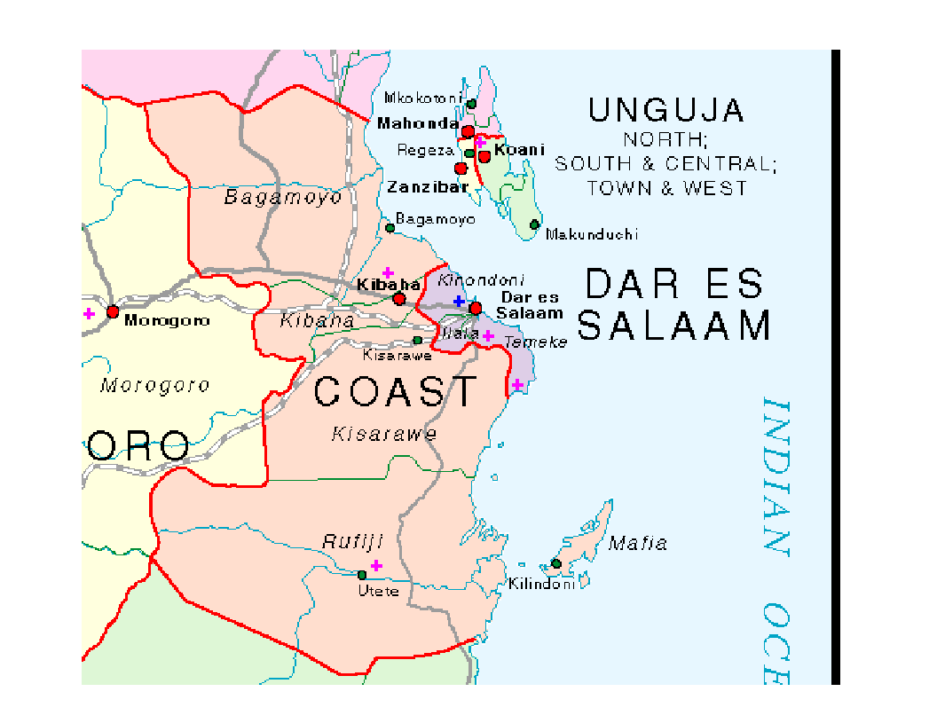
Proposed Clinics +
Existing Clinics +
|