In Response To
"A Call For Papers: The Fifth International Conference On Spatial Data Acquisition For GIS",
I offer the following project:
Titled
A Search For A Suitable Homesite
By
Dennis Anderson
Geography 26, Ethan Way Center, American River College, Sacramento
Spring Semester 2001
Abstract
I decided on a useful/practical subject for my project. My wife and I are considering a home relocation to the foothills. This project was designed to create a tool to aid in our decision process for determining which areas will and which areas will not fit our needs.
Introduction
Where do we want to live, where can I find data that will help us with this decision? I will search the Internet, search my employers' data library, and consider other possible data sources.
Methods
- I selected a non-projected, spheroid geographic coordinate system (NAD 27 Geographic). 7.5 min. quad maps were purchased, referenced to this system, and downloaded over the Internet through a company called 'SureMaps.com'.
- An interest area perimeter was established to be used as a guide to 'clip' (limit) the data gathered to this area (a line drawn around the purchased quad maps, and converted to a shape file).
- Waypoints of interesting locations and reference locations were gathered with a Garmin12XL GPS unit.
- A broad search of the Internet for additional data was conducted with limited success. Much of the data I did find was provided in formats I was not familiar with. Most likely formats compatable with ArcInfo, not ArcView, the program I am using. The ESRI site provided county demographics (which was later joined with county data from CDFG).
- I decided to use pre-release data from California Division of Mines and Geology. This provided the project with geologic data and seismic fault activity data. The data was incomplete and required some research to 'fill in the gaps'. Both data sets required re-projection to the NAD 27 Geographic system.
- I decided to use data from a California Fish and Game GIS data disk provided by the instructor as set of examples of spatial data. This data was projected to Albers Conical Equal Area, NAD 27 Datum; therefore required a re-projection to spheroid NAD 27, Geographic. The data included: primary landcover, soils, climatic sub-sections, government property, watershed, roads, cities, and county lines (which was joined with the county demographic data from ESRI).
- All data other than the quad maps was clipped to the interest area perimeter (intersected data).
Problems
- I was able to find good hardcopy data (some of it asbestos occurrence), which I scanned and traced, but due to ArcViews' limitations I was unable to project it and therefore could not use this data.
- After the quad maps were purchased, I discovered that most of the remaining data I intended to use was not in my chosen projection. Since I could not reproject the quad maps with ArcView, I had to go around the circle the other way and reproject all other data. More careful planning would have prevented this extra step.
- I discovered that much of the data I had collected was 'coded'. Abbreviations and codes were used in the data sets. This required research of the data subject to translate and understand many of the data fields. I used a geology text, a USGS geologic map, and state soils publications from the USDA Soil Conservation Service.
Lessons Learned
- Careful, complete planning (as much as possible) is more important to do 'up-front' than I anticipated. It is much more difficult and time consuming to plan 'on-the-fly'.
- Record all metadata at the time the data is collected, not later. It is very easy to loose track of a data source.
- Maintain original file names of collected data (use aliases if necessary). This makes backtracking for metadata information much easier (when the lesson above is not learned).
- Not all data is comprehensive. A data set's title may indicate coverage of a given area, but may be focused on certain special areas within the indicated coverage.
A Continuing Process
This project is not complete. I will continue to assemble data into this spatial database to further increase its usefulness to our relocation decision. I hope to add asbestos occurrence data, historic area mining location data, air and groundwater contamination data, and groundwater availability data. We'll further explore the foothills with a GPS unit. And I will develop queries based on our likes and dislikes. There are various possibilities for interesting queries of this data. I've enjoyed this project and I expect I will continue to enjoy it.
Results
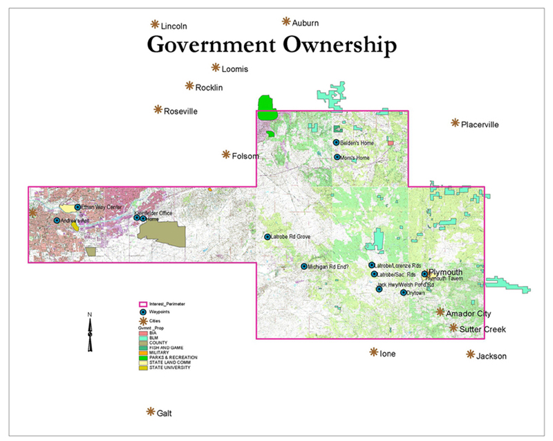
Area Quad Maps with Interest Perimeter, County Lines, Cities, Waypoints, and Government Property
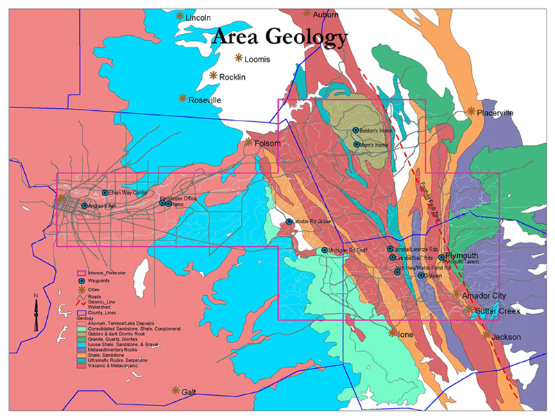
Area Geology with Area Fault Zone, Interest Perimeter, County Lines, Cities, Roads, Watershed, and Waypoints
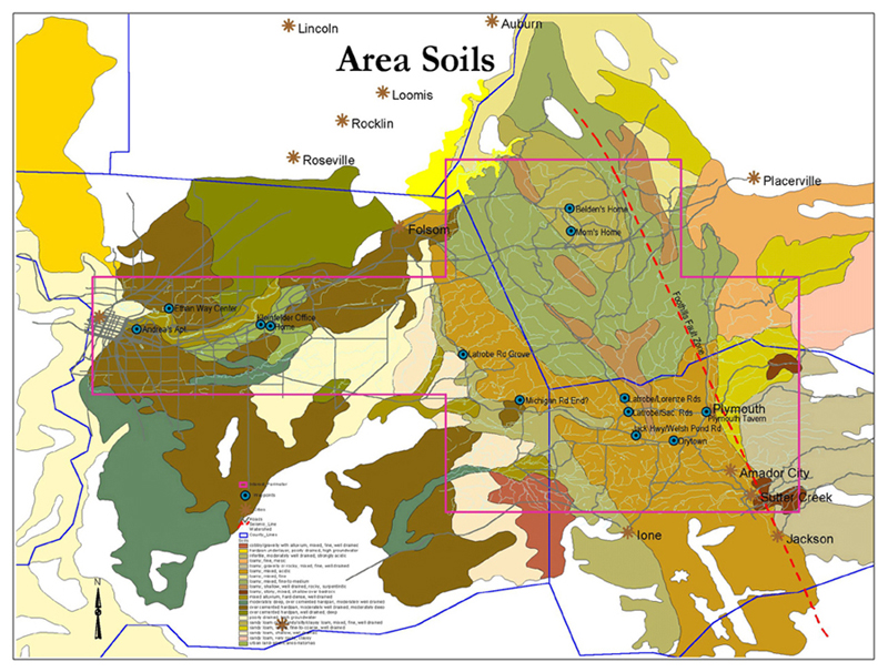
Area Soils with Interest Perimeter, County Lines, Cities, Roads, Watershed, and Waypoints
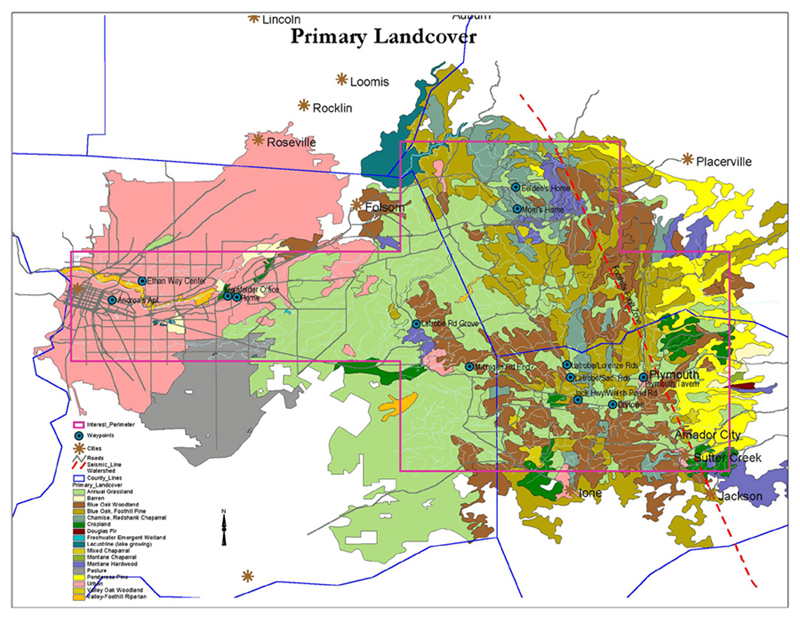
Area Landcover with Interest Perimeter, County Lines, Cities, Roads, Watershed, and Waypoints
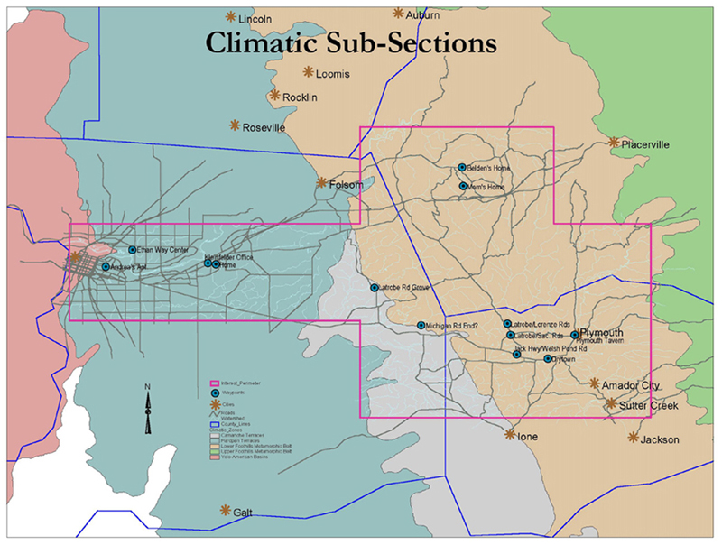
Area Climatic Sub-Sections with Interest Perimeter, County Lines, Cities, Roads, Watershed, and Waypoints
References
- SureMaps.com provided:
United States Geological Survey 7.5 minute Digital Quad Maps
- California Department of Fish and Game provided:
Roads Data
Cities Data
County Line Data
Government Ownership Data
Soils Data
Landcover Data
Watershed Data
Climatic Data
- California Division of Mines and Geology provided:
Seismic Data
Geologic Data
- ESRI.com provided:
County Demographic Data
Acknowledgement
Thank you Paul Veisze, for the interesting and useful knowledge you have passed to your students, it is greatly appreciated. And I enjoyed the dance.


