RIVER
GUIDE TO THE CHILI BAR RUN ON THE SOUTH FORK OF THE AMERICAN RIVER
Peter Bennett
American River
College, Geography 26: Data Acquisition in GIS; Spring 2000
May 15, 2001
The Chili Bar run on the South
Fork of the American is one of the most readily accessible sections of class
III+ whitewater in northern California. Nestled
within the Sierra Nevada’s this 5.8-mile long run passes through the granitic
Sierra Nevada batholith and ends in historic Coloma, home of Sutter’s Mill
where gold was first discovered in California in 1848.
This focus of this project was to georeference the major rapids on the
Chili bar run, providing the user with a map of the rapids, a description of
each rapid, and helpful information about river access.
Data for this project was collected and processed using a Garmin 12XL GPS
unit, ESRI’s ARCVIEW, and Microsoft’s Excel.
The South Fork of the American
River is part of the Western Sierra Nevada drainage system, beginning east of
Kyburz, flowing into Folsom Lake, and continuing west to where it joins the
Sacramento River. The South Fork of
the American River provides many spectacular areas for recreation; one of the
most popular stretches of this river is the Chili Bar Run.
Located off of Highway 49 between Placerville and Coloma the Chili Bar
Run is an approximately 5.8-mile section of river featuring many class III –
IV (depending on river flow) rapids. Due
to its proximity to the Tahoe area, the Sacramento Valley, and the Bay Area the
Chili Bar Run attracts thousands of whitewater adventurers year round.
The purpose of this project was
to provide an overview of the areas geology and history and to georeference the
major rapids on the Chili Bar Run, providing the user with a map indicating the
rapids location, and description of each rapid. Data for this project was collected using a Garmin 12XL GPS
unit, and the United States Geological Surveys (USGS) Coloma and Garden
Valley topographic quad maps. Data
was processed and mapped using ESRI’s ARCVIEW and Microsoft’s Excel.
The whitewater in Northern
California is world famous, much of which is due to the presence of the Sierra
Nevada mountain range. The Sierra Nevada mountain range is a north-south
trending geologic feature 50 to 80 miles wide and over 400 miles long.
This complex mountain range went through four primary stages of
development:
1. Over 230
million years ago (MA) the Sierra Nevada’s formation began in the Paleozoic
era when the area was mostly under sea and was receiving deposits of sediments.
2.
Between 65 and 230 MA during the Mesozoic Era the Paleozoic strata were
down warped in a gigantic complexly faulted synclinorium, which was filled with
contemporaneous volcanic and sedimentary detritus.
Following this the area was strongly deformed and intruded repeatedly by
granitic masses, and eroded to a depth of 9 to 17 miles.
3.
Less than 65 MA during the early Cenozoic Era the area went through a
period of relative geologic stability
4.
This was followed by a period of uplift, tilting, and faulting preceded
by and accompanied by volcanic activity in the late Cenozoic.
(Bateman, P. C.)
In the Vicinity of Chili Bar to
Coloma and Lotus the Sierra Nevada Batholith underlies the South Fork of the
American. This large plutonic mass
is granite to granodiorite in composition and makes for the spectacular geology
visible from the river. Rafters and
Kayakers putting in at Chili Bar should also note the Slate mine located just
above the put in on river left.
Passing through the heart of
the Sierra Nevada Batholith is the famous California Mother Lode.
The Chili Bar Run ends in the City of Coloma home of Sutter’s Mill.
Where on January 24, 1848 James Wilson Marshall discovered placer
deposits of gold in gravel banks along the South Fork of the American River. This discovery was to trigger the California Gold Rush.
Rafters and kayakers taking out in Coloma will find themselves at the
Marshall Gold Discovery State Park, where visitors can view the discovery site
and mining equipment (primarily placer mining).
The South Fork of the American
begins east of Kyburz and runs into the Folsom Lake and continues west where it
flows into the Sacramento River. The
Chili Bar Run is approximately 5.8-miles long with an average gradient of
31-feet per mile. The river is dam
controlled and located approximately 0.5-miles upstream from the put in is the
Chili Bar Dam, which is owned and operated by PG&E.
There are releases year round with scheduled releases during the summer
months for commercial boating. Permits
are required for commercial and private boaters.
Flows vary throughout the year
and during the winter and spring months it is best to check the flow via the
flow phone (530) 621-6616 or at http://www.dreamflows.com.
Summer releases generally vary from 900 cubic feet per second (cfs) to 2,500 cfs.
Winter and spring conditions however can range up to 10,000 cfs, at this level
the river changes drastically and scouting is advised.
Access to Chili Bar is quite
straightforward as far as rivers go. To
get to the put in coming from Sacramento take 50 east to 49 north in
Placerville. Then turn right onto
193 and continue for two miles until you reach the Chili Bar bridge.
During the summer months this run is a favorite for people throughout the
Sacramento Valley, the Reno Area, and the Bay Area.
Crowds can be a problem, and it is many a kayaker who has gone down a
rapid stuck to the bottom of a raft on this river during a busy summer day.
To avoid the crowds it is suggested to get to the put in early.
Parking is available on the north side of the river for a fee; however
free parking along with a short walk to the river is located on the south side
of the river just across the bridge. Kayakers
opting for the free method can put in via the small trail on the upstream side
of the bridge, Rafters however will find this put in a bit difficult and most
generally pay the fee.
To get to the take out, from
Placerville go past the turn off to 193 and continue on 49 to Coloma.
Free parking is available by Troublemaker rapid and involves a short walk
to your car; fee parking is available at the Marshall Gold Discovery State Park.
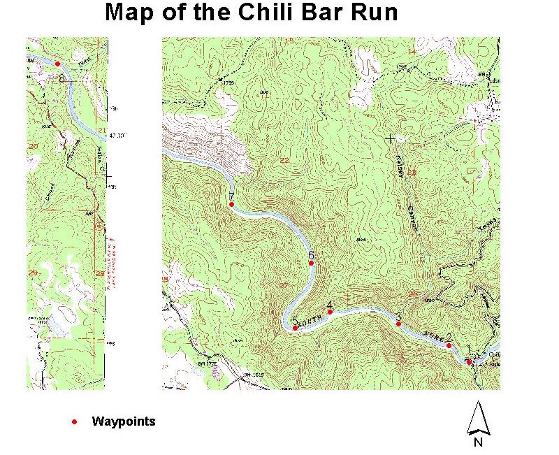
The table below lists the
rapids that were located during this project.
Please note that not all rapids have been identified here in part due to
an inability to acquire a 2D or 3D fix at all rapid locations.
|
Waypoint |
Rapid Name |
|
1 |
Chili Bar Hole |
|
2 |
Surf City |
|
3 |
Meatgrinder |
|
4 |
Race Horse Bend |
|
5 |
Maya |
|
6 |
African Queen |
|
7 |
First Threat |
|
8 |
Troublemaker |
The figure below shows a plot of the waypoints collected during this project on the Garden Valley and Coloma topographic quad sheets. Following the figure is a description of each rapid starting with waypoint one, located in the lower right hand corner.
Immediately after Troublemaker there is an eddy on the left that is used by some as a take out. Most head on down to the Marshall Gold Discovery State Park located approximately 0.5-miles downstream of Troublemaker on the left.
Data was acquired using a
Garmin 12XL GPS unit on April 24, 2001 along the Chili Bar run of the South Fork
of the American River. Each waypoint was averaged until readings stabilized then
saved. Waypoint numbers and the
corresponding rapid name were recorded in a field notebook, in conjunction with
the field of merit (FOM). The
average FOM was +/- 27 feet with a maximum deviation of 29.2 feet.
Waypoints were then downloaded
to a PC computer using Waypoint and imported into ArcView using the Av Garmin
extension. Waypoints were then
overlain on digital copies of the Garden Valley and Coloma 1:24,000 USGS
quadrangles and projected in Albers Equal-Area Conic.
The area of focus in this
project is part of a region of fascinating and complex geology, and the presence
of the Sierra Nevada’s provide a breathtaking backdrop to an area rich in
California history. People who wish
to run the Chili Bar run will find that with its close vicinity to the
Sacramento area and with numerous commercial outfitters present it is a run
worth doing numerous times.
Alt, D. D., Hyndman, D. W.,
1987, Roadside Geology of Northern California: Mountain Press Publishing Co.
Bateman, P. C., Wahrhaftig, C.,
1966, Geology of Northern California: California Division of Mines and Geology
Bulletin 190, p. 107-184.
DeCourten, F., 1994: Guidebook
to Selected Geologic Field Trips in Northern California: National Association of
Geology Teachers Far Western Section, p. 107-111.
Hill, M., 1975, Geology of the
Sierra Nevada: University of California Press
Holbek, L., Stanley, C., 1998,
The Best Whitewater in California, Third Edition: Watershed Books.
Section 5 Planning Context: http://co.el-dorado.ca.us/generalservices/parks/phase_II_report/section5_3.html
Garmin 12XL GPS receiver
ArcView v3.2
Spatial
Analysis Extension, v2.o
AV
Garmin Extension, v2.1.59
Waypoint v2.0.02