California Historical Landmarks: tools for educational and recreational enjoyment
Jim Condon
American River College,
Geography 26: Data Acquisition in GIS; Spring 2001
Abstract
I am always looking for new ways to challenge my eighth grade students to see the connections
they have to history. I began the project by locating historic sites within Placer County.
According to the California State Parks Office of Historic Preservation, there are 1070 state
historic landmarks in California, twenty of which are in Placer County.
The National Parks service has used GPS/GIS to preserve historic battlefields and to document
the resources of other historic and cultural sites within their control. With this in mind,
I wanted to place some information gathered in the field with GPS and other sources into a GIS
which I would then use to display to my students. What I found was that my ability to locate
and collect data on the landmarks in Placer County was limited by errors in the information
provided by the state Office of Historic Preservation. With this in mind, my focus changed to
include the inclusion of data I collected into a database maintained by California State Parks.
I see this as a project that would increase the enjoyment of all users of the resources provided
by the state for educational and recreational purposes.
Introduction
"How does this affect me?" is the rallying cry of many an eighth grade student in my social
studies classes. I often hear students complain that everything we study is so far away. Indeed,
not many have had the opportunity to see the battlefields of the Civil War, the homes and estates
of George Washington or Thomas Jefferson, or Independence Hall. Wanting to show them just how
much history there was surrounding them, I set out to find historic sites within Placer County.
After some research, I settled on locating California Historical Landmarks, documented by the
State Parks Office of Historic Preservation and described, with their locations, in the
California Historical Landmarks handbook, 12th edition. Most of the landmarks were within a
short drive for me, and some were close enough that students could see for themselves the rich
history of the area around them.
Background
The National Park Service uses GIS to map and preserve the historical integrity of National
Battlefields. With a combination of Historical survey data, GPS, GIS, scanning and internet
research, the Chickamauga Battlefield was mapped by the NPS's Cultural Resources Geographical
Informatin Systems Facility (CRGIS) in order to develop a battlefield map that would make it
easier to preserve and protect cultural and historical resources. (Burns, 1999)
The National Park Service's Heritage Preservation Services website offers information on current
GIS/GPS projects, many dealing with the mapping of national parks, landscapes, and historic sites.
With this in mind, I chose the California Office of Historic Preservation website to find
information on historic landmarks in California. The site has a listing of state parks, historic
places, and historic landmarks. The Landmarks are also listed in The California Historical
Landmarks Handbook, 12th edition. It was from this handbook that I found the location, numerical
designation, and names of historical landmarks in Placer County.
Methods
In order to show the location of Historical Landmarks in Placer County, I first created a view in
Arcview using census data, including layers for the county outline, streets, railroad line features,
and water bodies. I then began collecting waypoint data using the Garmin GPS12xl. At each
Historical Landmark, I took a reading and also recorded pertinent information about the site that
was not included in the State Parks handbook. I wanted to show what other features were at or
near the site for educational or recreational purposes. I also took pictures of the Landmark,
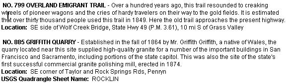
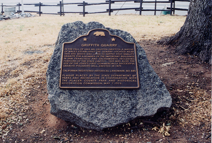
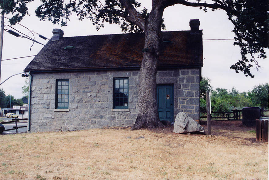
and, in some cases, the resources nearby. For example, the Griffith Quarry, landmark no. 885, has
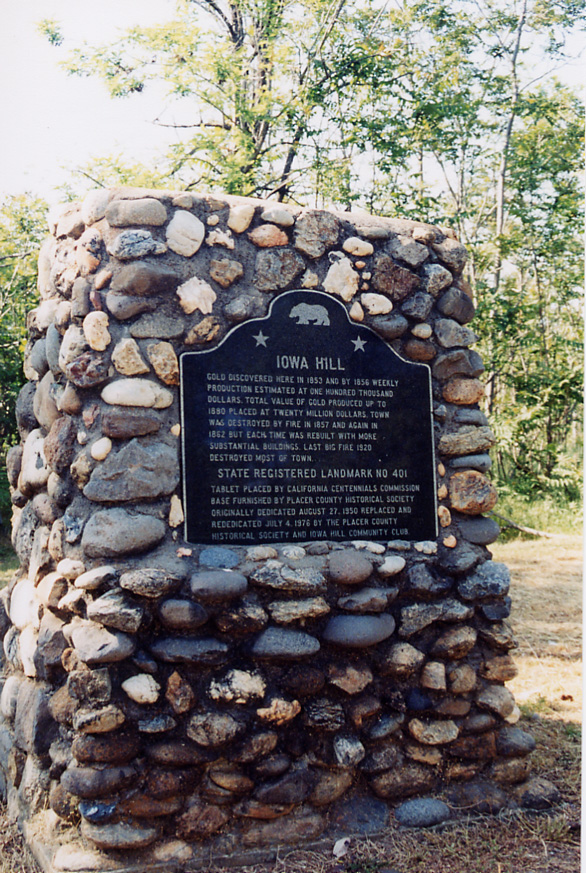
a small park and museum with parking on the site, whereas landmark no. 401, Town of Iowa Hill
is at the end of a long and winding road in the Auburn State Recreation Area, almost deserted by
comparison.
Upon completing my data collection, which for many reasons to be explained was
incomplete, I imported the waypoints into ArcView, creating a map that showed the landmarks in the
locations which I found them, and within the context of the Placer County streets layer.
Results
One thing that I found as I was collecting data in the field was the inaccuracy of some data
provided in the Historical Landmarks Handbook and the OHP's website. The collection of GPS
waypoints provided me with a concrete location to be placed within ArcView, and provided a
possible way to provide more accurate coordinates to users of the handbook and website. Since
this began as a simple way to show locations and proximity of landmarks to my students, the use
of Arcview and census data provided me with the best format to get my point across.
Analysis
When resources were accurate, the process of finding the landmarks and collecting data was enjoyable
and provided a wonderful opportunity to see parts of the county that I would not have discovered
otherwise. In the same way, inaccurate or outdated resources led to a discovery that, while much
more cumbersome in terms of time and effort, were useful in determining the need to bring GPS/GIS
into the State of California OHP in many of the same ways these methods are being used at the
national level. When confronting the problem of not finding a landmark in its designated location,
I asked local residents, referred to other maps of the area, or simply walked around the area to see
if it could be located through perserverance and investigation. And while some landmarks were not
available to be placed into GPS due to construction, or limited access to the sites, it is my
intent to fully document those locations. It is also a priority now to document the historical
landmarks and sites that are in surrounding counties, yet close enough to visit with minimal
effort. According to some local residents, the location and/or description of landmark plaques
changed anywhere from 2 to 20 years ago. While the cost of printing prohibits updating the
handbook on a yearly basis, with GIS and GPS, the digital database could be updated constantly to
maintain accurate records for the use and enjoyment of students, historians and just plain
tourists not wanting a three hour detour while looking for the gold discovery site of reputed
lawless character "Yankee Jim".
References
Burns, Bonnie. 1999. The Rocks of Chickamauga: Mapping a Link to the Past. GPS world. March:32-42.
California Office of Historic Preservation http://ohp.parks.ca.gov/landmarks/index.htm
National Park Service Heritage Preservation Services
http://www2.cr.nps.gov/gis/battlefield.htm