Margaret Stelmok
American River College, Geography 26: Data Acquisition
in GIS; Spring 2001
![]()
Planning a Survey and Mapping Protocol for a Local Weed Management Area
Margaret Stelmok
American River College, Geography 26: Data Acquisition
in GIS; Spring 2001
![]()
Abstract. Global Positioning System (GPS) surveying and Geographic Information System (GIS) may provide convenient and effective mapping tools for county agriculture personnel as they carry out the objectives of a regional Weed Management Area to survey, map, and control infestations of noxious weeds on private and public lands. However, to use these tools to their full potential, WMA participants must devote some of their energies to clearly defining their survey goals and methods. In the rush to demonstrate progress, it is sometimes easy for 'weed warriors' to forget that the best results come from careful planning. This is particularly true when it comes to doing prerequisite weed surveys.
Introduction. In recent years, the problems associated with the proliferation and impact of noxious weeds have come to public attention and has lead to the formation of regional Weed Management Areas, or WMAs, whose members represent a variety of private interest groups and government agencies. Because the regulation and control of state and federally designated noxious weeds falls within the jurisdiction of the California County Agricultural Commissioners, county agriculture departments are usually primary participants in WMAs. A typical goal of most local WMAs is to identify a set of noxious weeds of particular concern, then map their extent and spread. However, members of some WMA's, including the Yuba/Sutter Weed Management Area, have limited training in vegetation survey and mapping techniques.
At least 21 California Agricultural Commissioners are developing some form of GIS as a tool to conduct detection, land use analysis, and enforcement activities. In the Yuba/Sutter WMA Memo of Understanding, the Sutter County Department of Agriculture is directed to map noxious weed infestations utilizing GIS. The purpose of this study is to develop a simple strategy that can be employed by agriculture department personnel to accomplish the objectives of the Yuba/Sutter WMA group, utilizing survey guidelines from various sources, Garmin III GPS receivers, and ArcView Desktop GIS. The study area will initially focus on known Arundo donax (giant reed) occurrences with the county of Sutter.
Background. There are 38 Weed Management Areas (WMAs) in California. They bring together the landowners, growers, environmental interest groups, public land managers (private, city, county, State, and Federal), and other interested parties of a designated geographic area, pooling their efforts and expertise to control invasive weed species. The WMA functions under the authority of a mutually developed memorandum of understanding (MOU) and is subject to statutory and regulatory weed control requirements. This is an important point with respect to perceived liability and the control of weeds in or adjacent to waterways (Headwaters, Inc., et al v. Talent Irrigation District). Many WMAs in California have been initiated by either county agricultural commissioners or local interest groups with the support of state and federal land management agencies such as the U.S. Forest Service, California Department of Fish and Game, and the Bureau of Land Management. WMAs are unique in that they attempt to address agricultural and wildland weeds under one local organization. They have contributed to public education efforts by printing weed identification brochures and organizing weed education and outreach events. Additionally, they have obtained grants to promote weed control efforts, coordinate research and demonstration plots, and institute joint survey, control, eradication, mapping, and other effective weed management projects.
A weed might be defined as a plant species that
is potentially invasive, harmful to native plants and wildlife habitats,
or detrimental to human activities. An exotic is anything out of
its native habitat. The Yuba/Sutter Weed Management Area members
have designated twelve exotic plants considered to be either detrimental
to the agricultural activities of the region or capable of diminishing
soil and water quality, wildlife habitat, and land values. Yuba and
Sutter Counties are rural regions a one-half hour drive north of Sacramento
via State Highways 70 and 99. Both counties devote a considerable
amount of their total land area to agriculture, particularly orchard commodities,
field crops, rice, and pastureland. Many irrigation canals are thus
utilized, and both rangeland and aquatic weeds are causes of concern..
Over the years, informal efforts have been made to document the extent
of noxious weeds as they are discovered, but now for the first time, the
Yuba/Sutter Weed Management Area group members are formulating a plan to
focus control efforts on twelve weed species of particular concern.
The Yuba/Sutter WMA
would like to construct an ArcView 3.2 pilot project to test the viability
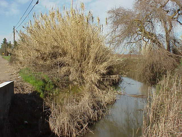
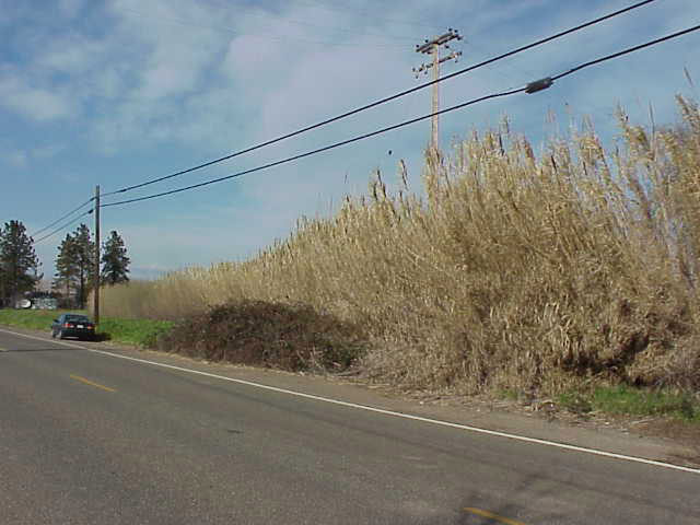
of surveying and mapping these twelve species within Sutter County. Arundo
donax (giant reed), an emergent aquatic grass commonly associated
with irrigation canals and ditches, was selected for this trial project
because time is of the essence for its control (see
biology), it takes relatively little time to survey, and while found
in numerous areas within Sutter County, it has not become widespread to
the point of being beyond control. The ArcView project will incorporate
GPS and field data on Arundo donax locations with existing Sutter
County land management, waterway, and road spatial data. Field staff
of the Sutter County Department of Agriculture will conduct field surveys
and be responsible for weed control measures.
Methods. The field staff has used
Garmin III GPS receivers for about two years and feel that they generally
provide an acceptable level of accuracy for most of their needs.
Assuming that GPS would be the tool of choice for data collection, WMA
participants considered various brands and types of GPS units before deciding
that Garmin IIIs, to be used by a crew with knowledge of the survey area,
would be sufficient to fulfill the WMAs mapping goals at a cost palatable
to all. In January and February, 2001, an agriculture department field
assistant with extensive knowledge of the area and experience with Arundo
collected GPS waypoints with a Garmin III recreational GPS receiver.
The waypoints were subsequently downloaded using California Department
of Fish and Games Waypoint Plus software and mapped
to an ArcView project. At the time, the surveyor had devised a standard
noxious weed survey form, but did not employ it for this survey because
he thought that with a GPS receiver, he would not need a datasheet.
Because insufficient field data was collected at the time, it was decided
that, before performing actual weed control, some initial research and
planning would be devoted to constucting a field datasheet. Team
Arundo del Norte provides a good starting point with a "windsheild survey"
form available on-line. (sample
1). Field survey and mapping guidelines were gathered
from several sources
and explained to the field crew prior to devising our own data
collection/data dictionary sheet that could be used to
document pre-treatment surveys. The ArcView project incorporates
GPS data on Arundo donax locations with existing Sutter County land
management, waterway, and road spatial data. A preferred control
strategy for Arundo calls for foliar herbicide applications applied
during a 6-7 day "window" in late September, early October, just prior
to winter dormancy (see
"control"). A baseline survey, with site photographs, will be done
in late August or early September, prior to the initial treatment.
Follow-up surveys and photographs will be done at the same time each
year prior to treatment. At the time of this writing, herbicide applications
near waterways have been suspended because of litigation addressing the
legality of certain herbicide applications adjacent to any type of waterway
(Headwaters, Inc., et al v. Talent Irrigation District). The
weed management area is considering a basal treatment strategy that calls
for chopping individual clumps of Arundo, then spot treating the
base with herbicide. This method will be much more labor intensive,
may have to be done earlier in the year, and limits control to young, less
established stands..
Analysis. We are learning as
we go. The immediate need is to develop a systematic survey and data
collection plan that takes into account the growth and dispersal patterns
of the target plants. Survey and mapping strategies will be different for
each weed project. Arundo spreads in a linear
pattern along roadways and ditches, so GPS may be useful to measure
the principal dimension, the length, of the occurrence. Plants such
as purple loosestrife, which multiply in a radiating pattern, would require
some adjustments to the survey procedure to provide more accurate and useful
map features, such as polygons with reasonably accurate areal measurements.
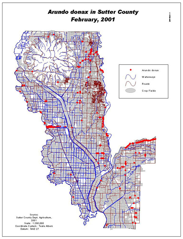
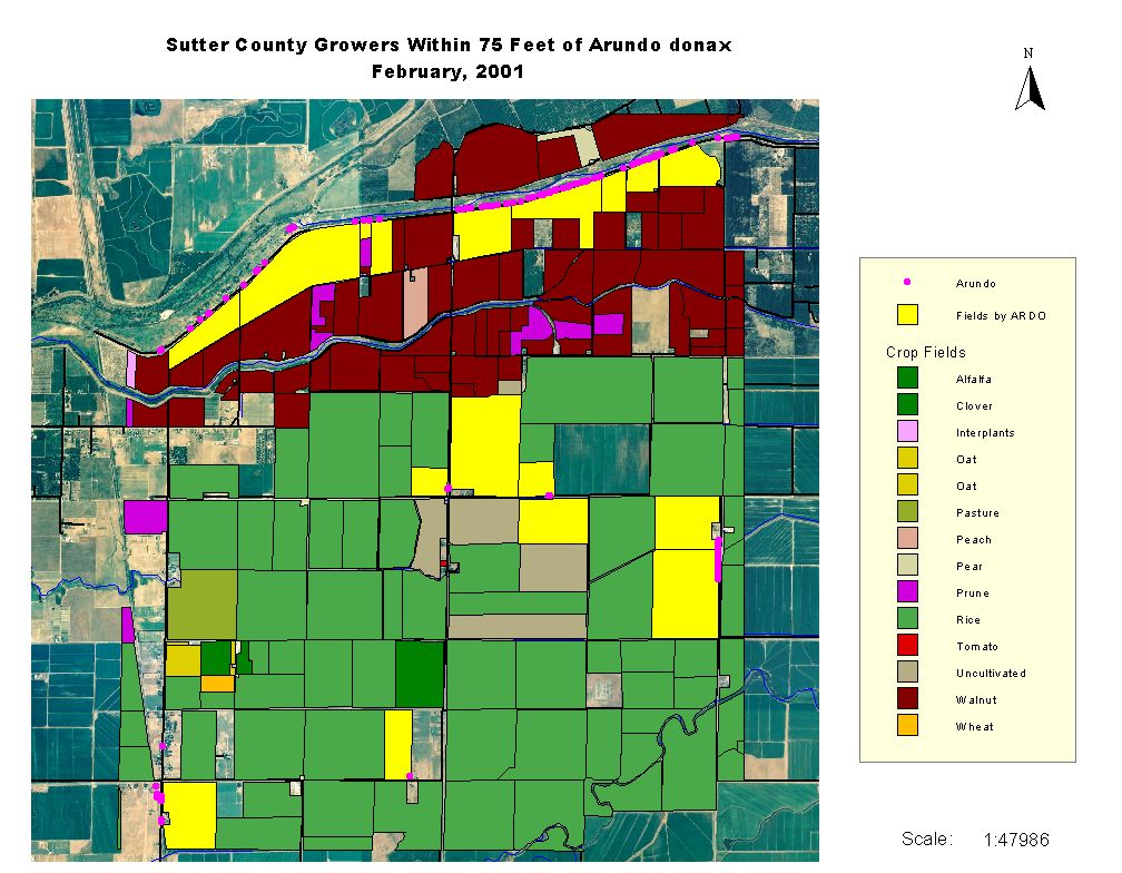
Sutter County has the hardware, GIS software, and spatial
data already available to provide context for the survey data.
With these additional data layers, we can derive surrounding land use information,
ownership, location relative to roads and waterways, etc. (see
sample map) We anticipate that weed data from our mapping project
(with the permission and cooperation of landowners) will be shared with
the California Department of Food and Agriculture (CDFA). An
MSAccess database, together with the spatial data in ArcView, is being
designed to provide the following information: (1) who to contact
about selected infestations, (2) what the current cropping activities are
in the surrounding area, (3) geographic coordinate and location information,
(4) data on control efforts and costs, and (5) data on the size of the
infestation over time. The database is intended to be an in house
tracking tool, not a public information source and, as such, will not be
designed to conform to public agency metadata standards.
Conclusion. An important goal of
this project is to visually compare the results of control efforts on target
species. At the time of this writing, we have waypoint data for Arundo,
but must have more complete field collection data. We are in the
process of experimenting with several datasheets and survey procedures
to discover which will be most practical in the field. We have
mapped the preliminary waypoints as point features and are developing a
simple database to supplement the geographic data that will allow us to
track the characteristics of each Arundo occurrence. At this
point, we have a map useful enough to show extent, cluster patterns, and
adjacency to growers and waterways but insufficient to query sites based
on density, growth stages, future affects of control, or extent of spread.
Citations:
Free, Jim, et al., 2000. Guidelines for
Coordinated Management of Noxious Weeds: Development of Weed Management
Areas. USFS et al.
Schoenig, Steve, et al, June, 2000. notes
from Weed Mapping and Planning Workshop
University of California, October, 2000.
Proceedings of the Aquatic Weed School. University of California,
Davis
Links to internet sites of interest:
Team Arundo del Norte @ http://www.ceres.ca.gov/tadn,
devoted to the control of Arundo in central and northern CA
Calif. Exotic Pest Plant Council @ http://caleppc.org/
primary source for statewide exotic pest plant information; many links
to exotic pest plant information
Santa Margarita/San Luis Rey Watersheds Weed Management
Area @ http://smslrwma.org/; model Arundo
mapping project
CalWeed Database @ http://endeavor.des.ucdavis.edu/weeds/default.htm;
California Noxious Weeds Control Projects Inventory