Geography 26: Data Acquisition in GIS
Fall 2001
American River College
By Michael Garced
Instructor Paul Veisze
Abstract
Over 50 years of aerial photographs that have been captured by the California Department of Fish and Game's Air Services Division are in danger of being forgotten about unless steps are taken to geographically reference them in a GIS. The data contained in the low altitude photographs can be preserved in a digital format and made available to a wide viewing audience. This archive, stored at the Fish and Game's Air Services Office, is an invaluable resource for scholars, citizens, government agencies, and environmental groups in the local community, because it provides some of the remaining footprints of the land and resource usage on the Lake Tahoe shoreline. In this project I will attempt to geographically reference a representative sample of the aerial photos from the collection, and to create a demonstration database.
Introduction
Starting in 1950, the Department of Fish and Game Air Services Division started taking Aerial photographs of selected areas throughout California. Today aerial photographs are among the most important, widely available, and most commonly utilized kind of remote sensed image. The Air Services Division's low altitude collection of historical aerial photographs can be a very useful tool for government agencies and private organizations in many ways. An important feature of this collection is the relatively wide time span the photos cover. These aerial photographs can be used to continue environmental studies, restoration projects and any land planning issues that arise in the Lake Tahoe area. Aerial photographs are used by many different disciplines in Government and private agencies for such purposes as mapping, resource planning, engineering, land use planning, and agricultural monitoring. Private citizens also purchase them for hunting, hiking, and other recreational purposes as well as for inherent qualities such as an unusual perspective on familiar landscapes.
The Fish and Games collection of pictures include many sensitive locations around California. These include numerous Kelp Studies from multiple years (1955,1957,1959,1960,1963,1965,1967,1999), the Lake Tahoe Shoreline (1970), the California Coastline (1961,1970), the San Francisco Bay (1970) and Northeast California Habitat Assessment (1999). These photographs are just one kind of tool that can be used to provide data to make informative decisions concerning the preservation of the valuable natural resources in and around California. Aerial photographs can aid almost any planning or engineering project that deals with the shape, size, and location of land, water or cultural features. Mapping photographs can also serve as a valuable complement to existing maps. California's natural resources are becoming increasingly sensitive due to the boom in California population during the last 10 years. Aerial photographs also serve as a valuable tool for comparing the same coverage areas for detecting changes that have occurred over time. Steps need to be taken to ensure our natural resources are properly protected for future generations can use them.
There is a need to have these aerial photographs cataloged so that government and environmental agencies can have access to data to better prepare and inform the people involved in the decision making process. The problem is the Department of Fish and Game does not have easy access to view or interpret the photographs. Many years and many man-hours have been used to collect these aerial photographs for the Dept of Fish and Game. My approach to the problem is to collect the information from the logbooks, then create a database that can be used inside of Arc View. I will then use a digital camera to take pictures of the aerial photographs and then use Arc View 3.2 reference the photos using satellite image and quad maps of California as a base map for helping with finding the location of the aerial photo. Having these historical photographs accurately referenced on a map so that GIS technicians, Fish and Game employees and any kind of environmental or planning commissions can view them for potential information.
Trying to find ways of applying new technologies to collect, preserve, catalog, view and maintain aerial photographs can be beneficial in understanding the changing landscape of our environment and how the human population effects it. There is a great need to help preserve our environment for those future generations can enjoy it. New technologies have already changed the way that aerial photographs are taken. Digital cameras with the use of computers and GPS have helped pave the way for accurate and rapidly processed photographs.
Background
The history of aerial photographs have come a long in a relatively short amount of time thanks to the onset of the technology age. Aerial photographs are produced by exposing film to solar energy reflected from Earth. Black-and-white and color-infrared films are used today in both high and low-altitude aerial photography. Natural-color film is used more rarely because it can be affected by atmospheric haze. The aerial photographs contained in the Fish and Games logbooks are mostly black-and-white with a few jobs that were taken with color film. The height of the plane when the aerial photos were taken is varied with altitudes between 2400 feet to over 12,000 feet. In the early years of acquiring aerial photos the Air Services Division used two different camera's, the K-22 and later the K-17.
There are many landmarks that a pilot can use to locate his or her location while flying in the air. But what if there are no major landmarks in the area to establish a position. This is where the success or failure of the job rested in the knowledge of the pilot in his orientation of the land. Where once a pilot would simply look at a map of the coverage areas of the job and compare land features, elevation features and other criteria to find their photographing destination. Now with the use of Global Positioning Systems (GPS) the pilot can take a lot of error out of the process in finding the location of any given location. Computers and digital cameras now offer a different method of capturing and displaying pictures that also create new ways of analyzing the data.
The job that caught my interest after looking thru the logbooks was the Lake Tahoe Shoreline job that was captured on October 13 1970. This job had 197 photographs that were color negatives along with 6 miles of shoreline with black-and-white film. These pictures sparked my interest because there are many issues that Lake Tahoe has to address in the upcoming years concerning the basin's environment. These aerial photos are a great source of information for both the public and research organizations. The USGS just announced a pilot project in the Lake Tahoe area that is called the national map. Lake Tahoe was selected along with a few other states to test out the national map project. The national map's vision is a seamless map that will have no boundary that will be updated on a regular basis along with different data sets to overlay over each other to compare trends and potential problem areas or environmentally sensitive areas. Along with the map pilot project Lake Tahoe has a website with all kinds of data layers of the Lake Tahoe area for the public to view. To get more information about the national map pilot projects, and the Lake Tahoe Clearinghouse click on the following links.
There is more information on The National Map Website
Check out the Lake Tahoe Data Clearinghouse
Methods
Acquiring the Dept of Fish and Game's Air Services Division logbooks was the first step in the acquisition of the data. The need to have these photographs in a digital format is long overdue with the new technology recently available. I collected samples of the logbooks accompanying the photographs. Using a photocopying machine I made a couple of copies of the log books in case something ever happens to the original there will always be copies for reference. The other benefit of making multiple copies is that the logbooks can be viewed at home since the logbook could not leave the site. Then I went thought the logbooks to get familiar with the kind of metadata that came along with the film, I needed to find out exactly what kind of data I was working with. The decisions that I make now for developing my database will affect how my database will perform in the long run. The planning stage of creating a database is a very important step for the success of the database. There were two logbooks that accompanied the aerial photographs. The first logbook contained entries about jobs when the Air Services Division started taking photo's in September of 1950, until November of 1977. This logbook included information such as the date of the job, flight height, and number of pictures taken, Job code and in some cases flight path. The second logbook started in January of 1978, and is still used today.
One big difference between past aerial photos compared to today is in the way the current aerial photographs are stored. Instead of being stored on film in a canister where precautions are used to help preserve the film. New technologies introduced digital cameras and computers along with new ways to store aerial photos. These technologies allow one to store photos in digital format that preserves and can enhance the image better than any previous methods before. I created a database where all of the information contained in the logbooks is now in digital format as a .dbf file to be used with Arc View computer software. Since I only could use a sample of the logbooks, I took some entries from the beginning, middle and the end of the logbook in order to get a good sample to work with. When I created the database for the photographs I used two separate .dbf tables, a master table for the main information in the log books and a link table for more detailed information that can be linked along with the master table. These two databases can be used together or separately depending on the user. After I selected my set of jobs for the database, the next step was to open a few canisters to make sure the information contained in the logbook was correct in its photograph location. The log book listing are under job names that are numbered chronologically with multiple photos per job ranging from as few as a dozen photos, with some jobs containing over a hundred depending on the goal of the job.
One of the big factors that I will have to deal with is how old is the photo that I am working with along with the resolution of the image. The accuracy of the logbook in conjunction with the photos will determine how difficult or easy it will be to reference a particular photo to it's true geographic location. I will be using multiple software programs and computer components to help reference the aerial photographs to ultimately create an image catalog that can be used inside a GIS. Some of the software includes the following Arc View 3.2, (DRG tools and DFG Geotools that are Arc View extensions, Street Atlas, Paint Shop Pro. The computer that I used for the project has an external hard drive attached to the computer. Since I am using 2000 SPOT images of the entire state of California, a lot of hard drive space is needed to view and pan around the state. I will also be using 24k quad maps of the entire state of California to help put names and roads into geographic order along with the satellite imagery to help in the location process. I used the DRG extension inside of Arc View to help with the overlay process. I used the black features from the 24k quad maps of California to help give me the place features and place names on the California SPOT image. I also overlaid the red features from the California quad maps to shows quad outlines and roads on the SPOT image for additional reference points.
Then in order to help acquire the coordinates of my photograph fast, I used Street Atlas, an off the shelf software program that allows me to punch in a name and get back results on the location. I can select my place name and automatically zoom in to the location and retrieve the coordinates. Once I have the coordinates to the photograph, I enter the coordinates inside Arc View's view using one of Arc view's extension named DFG Geotools to find the location on the SPOT image somewhere in California. Once I find the location of my aerial photograph, I then proceeded to find the center of my aerial photograph in conjunction with the Spot image, and then I created a point of the geographic location of the photo inside of Arc View. Once I reference all of the aerial photographs, I will create an image catalog of the aerial photographs that can be imported into a GIS. Instead of having to go find each individual aerial photograph and import it into Arc View, one can just add the image file with a .dbf file attachment and all of the aerial photographs will appear in the view.
I set up a digital camera to take sample pictures of the Lake Tahoe shoreline job of 1970. I used a light table to view the aerial photos after the photo location was identified. The digital camera was secured above the light table to capture a good picture of the aerial photos being sampled. After a picture was taken, the picture was brought into Paint Shop Pro and was cropped and enhanced and saved as a .jpg file. This .jpg file was used inside of Arc View 3.2 using DRG tools to help pin down the location of the aerial photo on top of the California quad maps. This is just a basic method that was used to get good quality results. If a more expensive method is used to complete the same process used here the results will provide a higher quality end result. The addition of a scanner instead of the light table and digital camera to capture pictures can increase the quality and resolution of the outcome.
Results
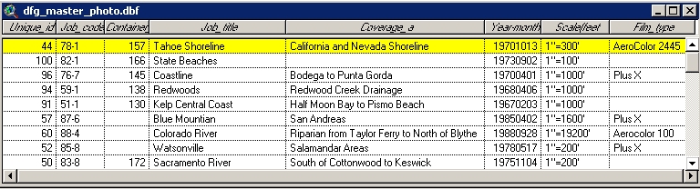
Here is an example of the database that was created from the information contained inside the aerial photo logbooks. The database was used in an Arc View 3X environment.
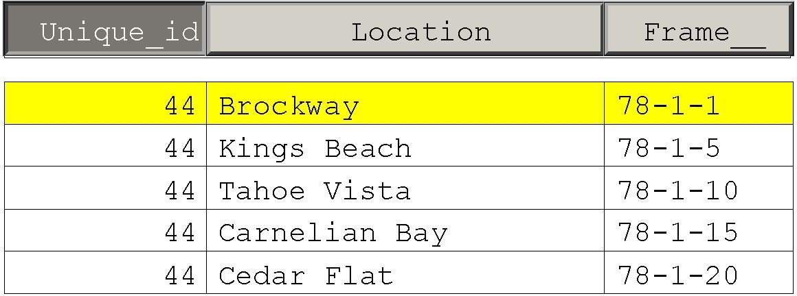
This is a link table that was created to be used along with the master photo table.
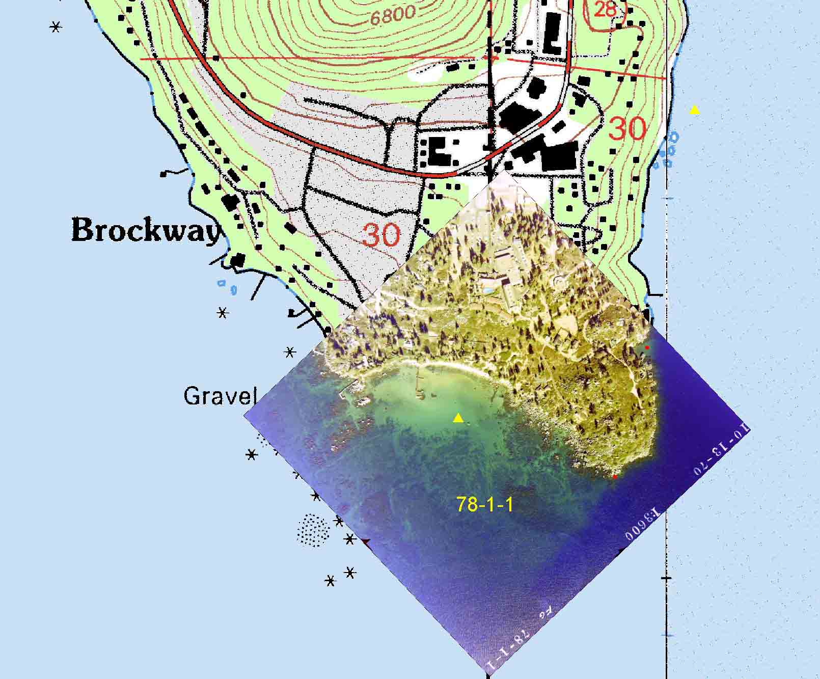
This is a aerial photograph of Brockway along the north shore of Lake Tahoe in 1970. The photograph was referenced to its location and overlayed on top of 24k quads of the Lake Tahoe Lake and surrounding basin.
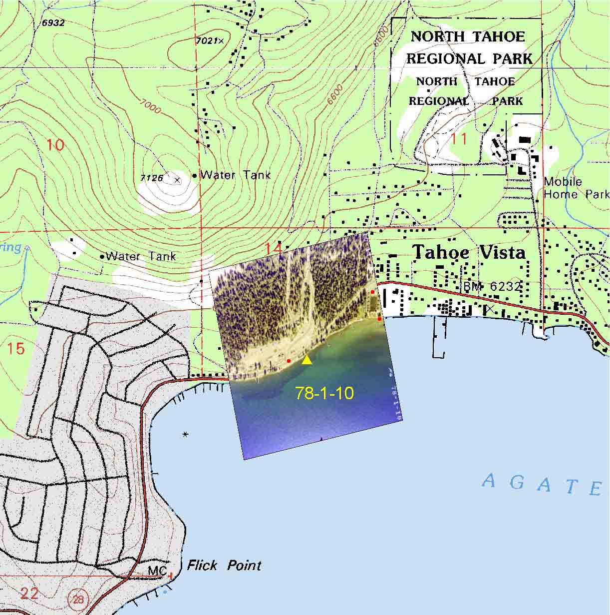
Here is a image of the Tahoe Vista shoreline from 1970 using the same process. This photograph was also overlayed on top of 24k quad maps.
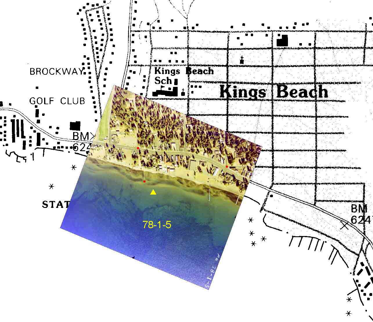
This photograph of Kings Beach from 1970 revels a excellent view of the sand patten just offshore. This image is overlaed on top of the 24k quad maps but with only the black features visable.
Analysis
I learned many important lessons during my time spent working and putting together this project. During the time spent on my aerial photograph project I was exposed to a few new types of software programs and extended my knowledge on others, it has been a great learning experience. This project demonstrated a relatively low cost method could be used to convert low altitude aerial photographs in a digital format to be used inside of a GIS. Being able to successfully demonstrate a low cost method of data acquisition with this collection of California historical photographs is a breakthrough. Having a digital archive of this historical photography will introduce a new way of accessing the collection of photographs. The users of the database could access either the indexes or the data by using key words to locate a wanted site of interest to find out what kind of photo coverage there is of the area. Using these aerial photos inside of a GIS will allow for the addition of different layers to the view to help for a better understanding of the landscape. Having a completed digital archive of California Fish and Game's aerial photography will provide a rich and valuable information resource that would span over 50 years. One way to increase the quality of the images is to set up a scanner to capture the images. This will increase the overall cost of the project but the outcome would be very beneficial depending on the use of the final product.
Conclusion
We are now living in an age where everything that moves or changes over time is being measured. Fortunately, we also live in an age when the computing power and information management tools are in place to allow people to use data productively. There is still a need to establish this historical aerial archive, first the overall preservation of the resource and second the access of scanned images in digital format for the growing community. Furthermore having a digital archive will provide a greater access to the data that is not currently available using print film. Aerial photography is currently used by many different state and government agencies concerned with the environment, natural resources, transportation, social services, and population. Having this type of collection would provide a unique and complementary resource to other files such as California state agency databases, census and population data, and legislative information systems. Since this project will be integral to the information operations of many state, county, and city government agencies, it is anticipated that a significant amount of time will need to be spent in contact with these organizations about their interest, their needs, and how these can be met within the scope of a larger project. The preparation of funding proposals to various state and federal government agencies, as well as private sources, will serve as another assessment of the future success of this aerial photograph project.
References
DeMers, Michael N. Fundamentals of Geographic Information Systems second edition 1999, : New Mexico St University
Hohl, Pat ED. GIS Data Conversion Strategies-Techniques-Management 1998, : Albany, New York
U.S. Geological Survey, Aerial photography frequently asked questions 1997, : Sioux Falls,South Dakota, EROS Data Center, electronic version