Identification and Location
of Environmental Plants in Davis, CA
Geography 26
Fall 2001
Yazmin
O’Quinn
Abstract
Environmental Horticulture 6: Introduction to Environmental Plants is a course offered at the University of California at Davis where students are expected to learn the classification, nomenclature and variation of 150 common environmental plants. Plant geo-coordinates, base maps, and digital images were all obtained to provide students with a Geographic Information Systems tool for easily locating these plant species within the limits of Davis. Expansion of this project would include the collection of more plant data points, true images from those sample points, and the creation of a user-friendly customized application in ArcView or with MapObjects for easy display and manipulation of this data.
Introduction
In Environmental Horticulture 6: Introduction to Environmental Plants (ENH 6), a course offered at the University of California at Davis (UCDavis), students are expected to become familiar with over 150 environmental plants commonly used in landscape architecture including the classification, nomenclature, and variation of environmental plants, floral and vegetative characteristics, characteristics of plant groups and the developments and maintenance of cultivars. Examples of these plants can be found throughout the UCDavis campus and the city of Davis itself. The goal of this project is to create a geographic information systems (GIS) tool for students of this course that will provide geographic locations, contain digital images, and include common characteristics associated with these environmental plants located within the city of Davis.
Background
ENH 6 is a ten-week course offered in the Environmental Horticulture department at UCDavis. The course is a undergraduate class with no perquisites besides a willingness to learn more about the common plants found in the surrounding environment. Throughout the course, students become knowledgeable in classification of higher plants, flower characteristics, leaf characteristics, plants and their environment and plant selection. Students also get to test their knowledge by learning how to identify these plants based on physical characteristics.
There are 41 families of plants and 150 plant species that are covered in this class. Every week during laboratory exercises, students are introduced to a select set of families and the plants belonging to those families. It is understood that by the end of the course, the combination of the lecture and laboratory exercises will result in an ability to identify common plants used in landscape architecture as well as how these plants improve the environment.
The creation of a GIS tool that provides not only locational information about common environmental plants, but descriptive data and digital images is accomplished through the collection of field data points of the 150 plant species located throughout Davis, location of appropriate base maps and associated layers visually describing the sample area, and the capture of images of those plants via digital camera.
Methods
Location of the exact environmental plants covered in ENH 6 for the city of Davis does not exist in any known dataset; therefore the creation of this data was necessary by use of a GPS unit. Once an area was identified as suitable, plant locations were recorded and identified based on their physical properties. Internet searches were performed to locate base maps and other data layers appropriate for the display of these newly acquired data locations. Digital images would need to be captured at the time of GPS sample data collection with a medium to high-resolution digital camera in order to render an accurate visual representation of the plant species.
Results
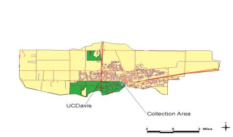
One of the many goals of this project was the location of plant species immediately adjacent to the UCDavis campus (see Figure 1 and 2). The older neighborhoods alongside the eastern border of the campus display a wide assortment of environmental plant species covered in ENH 6. Also, the ease of access to the sample site by students was an important issue to consider as well. Identification of plants was based on knowledge of common plant characteristics and visual recognition. Data points or waypoints were collected using the Garmin GPS12XL Global Positioning System (GPS) receiver. Waypoints were imported into ArcView for visual and data analysis via the Waypoint+ software and the AV Garmin software extension. For this project, out of the 150 plant species, 38 plant locations were obtained via GPS. For the size of the area designated for this effort, not all plant species could be located.
Figure 1. Map of the city of
Davis

Figure 2.
Data Collection Area
Another goal of the project was to create a tool that provided students with locational information regarding these common environmental plants. The data required to meet this goal would contain detail on a street-level basis as well as landmarks for reference purposes. GDT Dynamap/2000Ò available via ArcData Online from ESRI proved to be the appropriate dataset. Dynamap/2000Ò is vector based data projected in a geographic coordinate system in the 1983 North American datum (NAD83). This dataset contained zip code polygons, water polygons, water segments, transportation terminals, streets, major retail centers, railroads, parks, institutions, highways, county boundary, large area landmarks, and airports as line segments, polygons, or points. The level of detail in this GIS dataset is not free of charge. ArcOnline charges $15 per zip code or $10 for multiple zips codes of Dynamap/2000Ò data. The data for PC or Unix systems can be downloaded in seconds from the website as a zipped file.
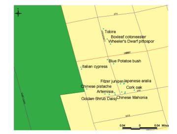
Due to lack of a digital camera at the time of sample data collection, digital images provided in this project were obtained from the Environmental Horticulture web page.
Analysis
There were drawbacks to collecting data points during the Fall/Winter months that included having to plan around the weather forecast and time change. Identification of plant species during rain or fog or when less light was available because of the return of standard time was difficult. These two situations caused delays in the collection and processing of data points. Also, many of the plant species were deciduous and were losing leaves, flowers, and fruit in preparation for winter dormancy. Identification of deciduous plants during this time became very challenging.
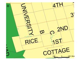
As stated in the GDT Dynamap/2000Ò User Manual, “Changing the projection may slightly effect coordinate precision resulting in less than exact overlays in enlarged views.” During the sample data collection, the GPS unit was set to NAD83 to correspond to the datum of the base map. NAD83 was also maintained during the uploading process of data from the GPS unit to the Waypoint+ software. This created a perfect overlay of waypoints onto to base map layer (see Figure 3). The base map itself is composed of several layers: streets, highways, county, and land areas. The street and highway layers provided attribute information in the form of addressed roads of all types. Using the auto-label function within ArcView, the streets and highway layers were labeled with the correct street names for accurate reference information on the location of the plant species data point. The county layer did not properly represent the county of Yolo since the data set was purchased by zip code, not county. However, the layer does cover the entire city of Davis, which houses the location of the area of focus for this project. The land area layer features all landmarks within the 95616 area code, which includes UCDavis. The contrast of UCDavis to the location of the sample data points on the map provided an additional reference to the location of the plant species within the downtown area of Davis. Text describing the waypoints was added to the attribute table and used with auto-label in distinguishing the locations of environmental plants in the area adjacent to UCDavis (see Figure 4).
Figure 3.
Waypoints Figure
4. Waypoints with Labels
Conclusion
For this project to be beneficial to the students of ENH 6 and meet the described goal, the sample area should be expanded to record the geographic coordinates for more than 38 out of 150 plant species. And during that sample collection, digital images need to be captured to record the maturity, location, and physical state of the plant species.
To create a true GIS tool for the ENH 6 students, customizing ArcView or creating a customized application with MapObjects is necessary in providing them easy access to data and plant locations required for the class. The goal for this project stems from the assumption that the students will have some knowledge or familiarity with ArcView or ArcExplorer. By limiting the functionality of ArcView or creating a specific application using MapObjects, a user-friendly application can be created and be truly beneficial to the students of this course.
References
ArcData Online website: www.esri.com/data/online/dynamap/index.html
Environmental Horticulture 6: Introduction to Environmental Plants Lab and Discussion Manual. Fall 1999
Environmental Horticulture Department at UCDavis website: envhort.ucdavis.edu
GDT Dynamap/2000Ò User Manual