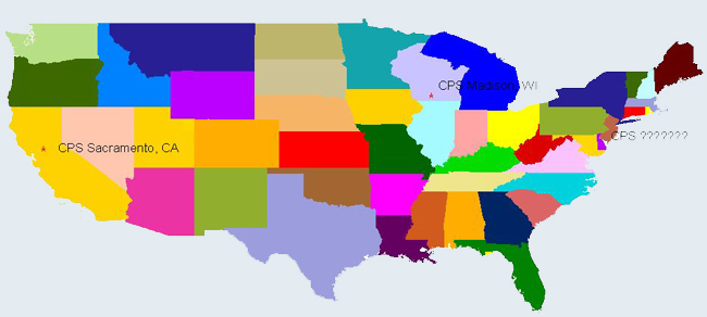
Assessing the East Coast HR Culture Teresa Webster Abstract CPS Human Resource Services is considering expanding to the east coast of the United States. A GIS database was implemented using ESRI ArcView software to aid management to spatially reference potential sites for a new office. Data were obtained from the Internet, sourcebooks and management; converted to coordinate points; and added to a base map of the United States. Analysis of the collection process is discussed. Results were presented to CPS management and the possibility for further development of the GIS acknowledged. Introduction CPS Human Resource Services provides general HR support to public and non-profit agencies. For instance, testing, classification and salary studies, and sexual harassment/civil rights training are examples of current projects. CPS’s central office is currently located in Sacramento, California. A satellite office was established in Madison, Wisconsin in 2000. The company is presently considering expanding operations to the east coast of the United States. To aid management in the decision making process for selection of a suitable site, a database and associated GIS (using ESRI’s ArcView software) was created.
Methods Unprojected state shapes were obtained from ESRI’s Digital Chart of the World and added to an ArcView project. CPS’s current office locations were added as points.
Using GIS to Assist Management in Selecting the Best Location for an Office on the East Coast of the United States
Geography 26 Fall 2001
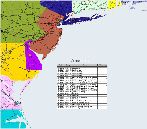
In the planning stage, besides the basic geography of the area, the locations of competitors’ offices and state/local personnel offices were added to an ArcView (ESRI) project and buffers placed around these points for analysis. Data needs were further developed to incorporate management requests such as adding present and future intermittent consultants, national personnel organizations, law enforcement and social services agencies, and possible contacts (Johnson, 2001). The possibility of network analysis was also discussed (i.e. travel distance from an intermittent consultant’s home or office to a state’s Department of Personnel offices).
Data on CPS competitors were researched on the Internet at www.hr-guide.com . Management wanted a few companies not found on this site included. Contact information for these companies was also located on the Internet. Governing magazine’s Sourcebook 2001 was used to collect state and local agencies’ contact information. The national headquarters for the personnel organizations: IOMA – The Institute of Management and Administration, SHRM – Society for Human Resource Management, and IPMA – International Personnel Management Association were researched on the Internet as well.
Once the addresses for all the above entities were obtained, Mapblast by Vicinity at www.mapblast.com was used to obtain decimal degree coordinates for each of the locations.
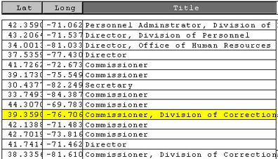
These coordinates and the corresponding contact information; agency name, address, state, zip, phone and website were entered into separate Microsoft Excel spreadsheets - competitor, state agency, local agency, city agency, current CPS locations, and the three personnel organizations previously cited. These spreadsheets, saved as dBase IV files, were then added to the ArcView project as event themes.
Results
The resulting ArcView project was presented to the Senior Manager. While a final decision is not predicted anytime within the next two years, the GIS foundation and the ability to build further on this data has been recognized.
Analysis
As the project progressed, difficulties in obtaining data arose. For instance, the coverage data from Digital Chart of the World were “tiled” similar to USGS topographic quadrangle 1:24,000 maps. While the underlying global data were more easily managed this way, working with the shapes in ArcView proved unwieldy. For instance, Florida was tiled into several different sections. To present a “unified” Florida all the sections containing polygons with Florida had to be located and made the same shade. Each tile could have one or several states associated with it. Road data were even more difficult to present.
Another difficulty was that many of the state agency addresses listed in the Sourcebook 2001 were post office boxes, which cannot be used by Mapblast to determine coordinates. Occasionally, an actual street address could be discovered on each agency website. Also, while Mapblast proved to be fairly accurate, especially given the scale of this project, on rare occasions it couldn’t find a requested address.
Conclusion
CPS management will now be able to spatially visualize potential east coast office locations. Basic analysis, such as buffering to determine an acceptable distance from a competitor’s office, can be performed with the GIS software. If there is further management interest ($$$$) the database and GIS can be expanded and improved.
References
Johnson, Gib, 2001. Personal Communication. CPS Senior Manager.
ESRI. ArcView GIS 3.1 software.
ESRI 1993, Digital Chart of the World software and data dictionary.
Harkness, Peter, editor, 2001. Sourcebook 2001. Governing.
Internet sites used in the collection of data:
www.hr-guide.com
www.mapblast.com
www.ipma-hr.org
www.shrm.org
www.ioma.com