Title
Finding a Home (Through the Internet)
Author Information
Gail Donoghue
American River College, Geography 26: Data Acquisition in GIS; Spring 2002
Abstract
This project was begun under a very practical approach ñ a very personal goal and as my Geography 26 DATA ACQUISITION final. It would serve as my tool to provide me with data in which I could locate a house to purchase. Many varieties of data could be utilized ñ using the Internet, the possibilities were endless. Which sources of information and which direction(s) I choose to go, would be up to me. Little did I know where, when and how this final project would serve me!
Introduction
I began my DATA ACQUISITION Presentation as a GIS project using ArcView. I had already decided to use this opportunity to help me locate a home to buy in the Sacramento area. In this way, it would be practical and personal, kind of like ìtwo birds with one stoneî, so to say. I spent a good deal of time attempting to download various streets themes into ArcView, but with little luck. Some downloads would not project and others simply did not have the right format. My instructor and aide, Paul Veisze and Marsan Klein, explained to me that DATA ACQUISITION is not unique to GIS. However data can be captured, organized, summarized and presented to the audience, is DATA ACQUISITION. At this point my approach was to simplify my project and use the tools available ñ my own laptop and the Internet. I titled my project ìFinding a Home (through the Internet)î because thatís exactly what I was going to do for my class presentation and myself!
Background
The guiding principal throughout this GEO 26 project was that of practicality and principal: To exercise the meaning and art of data acquisition and funnel the data towards a personal achievement. Throughout the semester our instructor emphasized the complexities, concerns, essentials and design of data acquisition. This project, as simple as it appears, gave me an in-depth look at the vast array of available data and the subsequent complexities that persist when attempting to place and present the data. My background for this analysis consisted of a couple of GIS classes, but more importantly, a background of a personal quest ñ finding a home! This incentive kept me continually searching, cross-referencing, logging, comparing, and analyzing the information and metadata.
Methods
The first method entailed was a ìhands-onî approach. This consisted of simply driving around to various areas of Sacramento to establish a positive or negative response. I had no idea of the various regions of Sacramento ñ the river ways and neighborhoods surrounding both the American River and the Sacramento River, the downtownís business culture, the ìsmallnessî of the Fair Oaks Village, the hussel-bussel and new construction of North Sacramento, the outskirts (and ìoutbacksî) north of interstate 80, and the encroachment of neighboring towns such as Elk Grove, Rocklin and Del Paso.
A few gallons of gas later, I decided that cruzing the Internet would be a more practical approach. I began multiple searches through countless sites to gain a feel for the various regions. I quickly discovered that the Internet was geared to provide information regarding entertainment, recreation and events surrounding Sacramento. A lot of the data available also emphasized the adjacent countiesí attributes of recreational, entertainment and events occurrences.
This was obviously not the ìinformation highwayî direction I was interested in. Despite this disappointment, the Internet was my next method for data acquisition; not so much for the general view of Sacramento, but rather for information concerning local and neighborhood activities and resources. This is where the complexities lie. Raw data is simply raw data, taken at face value. I had a specific idea of where I was going and what type of data I was searching. Although there was an overwhelming amount of data at my fingertips, it remained out of reach, hidden somewhere in the periphery. I spent long hours going around in circles, sometimes even forgetting what I was looking for.
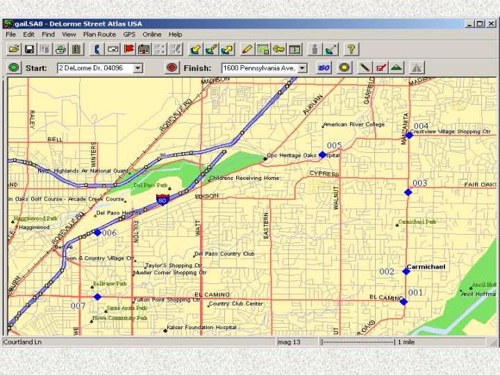
Meanwhile, I was concerned with my streets map background. I surely needed an adequate base map upon which my data (however vast or limited) would be projected in my presentation. Downloading projections is very tricky and also requires a working knowledge of spatial analysis, accuracy and a lot of luck! Mr. Veiszeís Streets Atlas proved invaluable. Unable to download the CD onto our class computers, I could still access my targeted area, isolate the projection and install it into my student file, without the ArcView program or CD download. From this basic beginning I began to develop my project with continuous data collected through web sites and urls offering information on homes for sale. I managed to stay within my targeted area, but not without a lot of practice. I can see how acquiring data is very costly and time-consuming!
Results
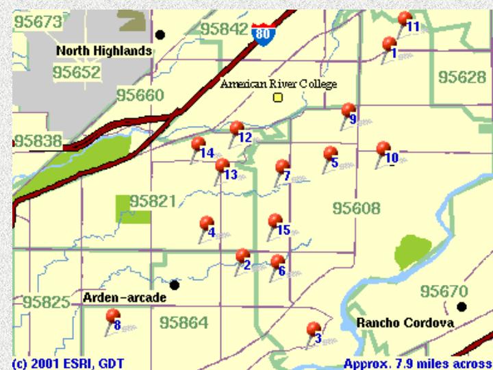
I was overwhelmed with volumes of information concerning Sacramento. I had sampled numerous neighborhoods through their respective zip codes, analyzing schools, libraries, roads and highways and crime statistics. Because so many neighborhoods were so similar to each other, I decided upon simply choosing an area closest to my family. Here I would earnestly look for available homes for sale through the Internet. These were the zip code areas of 95821, 95608, and 95825.
This is the map that I targeted as the potential home purchase site. I took my GPS unit and outlined the parameter. My area of interest as outlined by my 7 waypoints lies west of Manzanita, south of Winding Way, southeast of Auburn, east of Bell, and north of El Camino. I was now able to concentrate on homes available within this region.
The general information I gathered from the Internet showed a particularly good distribution of good schools within my selected area. I was able to analyze their statistics through a chart that was referenced to a map showing each schoolís location. This particular aspect exemplified the fact that my targeted area is fairly ìhealthyî and family oriented ñ a very important factor for me.
The actual inventory of available homes was acquired through two major web sites, ìRealtor.comî and ìReal Estate.comî. There are many real estate oriented sources but the majority of them are specific to a targeted audience such as recreational enthusiasts, high profile executive types, military, etc. ñ you get the picture. For the general information-seeking individual such as myself, these two web sites served the best.
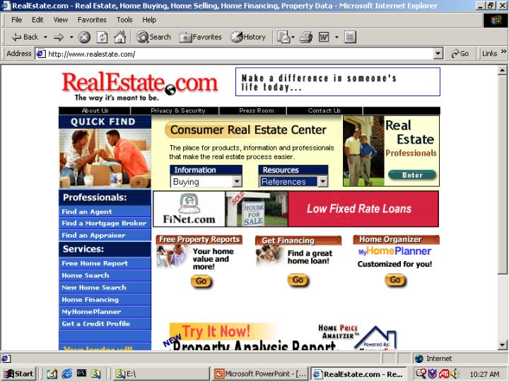
When accessing the inventory of homes, the potential buyer must review the homeís write-up, hopefully a picture, and then a pin pointed location on a map, all provided through the realtor. Some higher priced homes even feature a visual tour, but unfortunately, Iím not in this price range. This process of reviewing each house and locating it on a map is done over and over. The idea is to concentrate on a few good available homes at a time. Buying a home is a very taxing experience, both in patience and fortitude.
Conclusion
In conclusion, I found a house to buy! I bought it even before this project was complete. Of course I had to continue the project even while I was in escrow. At this point I figured it probably wasnít a bad idea to continue through the listings as I had been doing because escrow could possibly fall through. Unfortunately the house I bought was not listed at the real estate sites where my project took place. It was referenced to me and I simply drove to the location and put down an offer that weekend. Searching through the Internet gave me a very good background of the attributes of the local real estate market. I felt confident of my offer and it was readily accepted. In this case the data acquired for my project superseded the goal. The knowledge achieved through acquiring the data gave me the foundation to use the data as the foundation for my home purchase. Moreover, the lesson here was that data acquisition can go many directions. A particular goal may have been set, but as the project progresses the data can lead many diverse paths and the data that has been acquired may be many facetted, complex, pointless, overwhelming, or may lead in a totally different direction!
References
My data was obtained through the Internet sites Realtor.com, Real Estate.com, Sacramento.com, Sacramento Today.com, SacBee.com, and Living.com. The base map was obtained from the instructor, Paul Veisze, a CD entitled ìStreets Atlasî. The GPS unit I used to outline my area of concentration was furnished by American River College.