Data Acquisition in Central Park
Jacqueline Kennedy Onassis
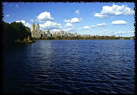
Reservoir
Chisa Nishii
American River College
Geography 26: Data Acquisition in
GIS
Spring 2002
ABSTRACT
The purpose of this study was data acquisition on Cantral Park and to compare various kinds of maps of the area of interest. Different data sources that were acquired in this project include GIS data, drawings and DOQs from the Internet. An overlay analysis on the map was conducted and the quality of both GPS and DOQ data was discussed.
INTRODUCTION
My goal was to conduct an "active" and "passive" data
acquisition and compare the data quality from both sources. Fist, I physically
visited the study area and collected GPS data on my own ("active" data
acquisition). Second, I searched in the Internet and acquired different kinds of
maps on the central park, including drawings, aerial photographs and DOQs.
("passive" data acquisition) Finally, maps collected from the Internet were
overlaid with my GPS points using computer softwares such as ArcView 3.2 and
Street Atlas to investigate the quality of the data I have collected. Possible
advantages and disadvantages of using GPS and DOQ over one another were
discussed.
BACKGROUND
Jacqueline Kennedy Onassis
Reservoir
The Jacqueline Kennedy Onassis
Reservoir is located inside the Central Park, New York. The reservoir was
completed in 1862 while the park was still in construction. The 106-acre water
which holds over a billion gallons of water was used to distribute fresh water
to Manhattan residents but it is no longer in use in that particular way.
Instead, it supports varied bird species. In fact, Bird watchers have sighted
five different species of gulls and over 20 species of waterfowl, grebes,
cormorants and loons. The reservoir also contributes significantly to the
environmental pleasure of the "run", especially in summer when water evaporates
from the surface and cools the surrounding air. The reservoir is probably best
known for the 1.58 mile jogging path all the way around. This path surrounding
the fenced reservoir provides hundreds of thousands of joggers each
year.
GPS Basics
GPS
stands for Global Positioning System. It is a worldwide radio-navigation system
that uses a constellation of 24 satellites to provide worldwide coverage for
location information. With GPS we can tell we you are to within less than 1
centimeter, depending on the type of system used. The following are the five
basics of how GPS works.
1) GPS is based on Trilateration
2) To trilaterate, GPS
measures distance from the satellite.
3) To measure distance, we need good clock
and at least 4 satellites.
4) Once the distance is known, we need to know the
satellite position (from satellites).
5) Location is calculated.
DOQ Basics
DOQ
stands for Digital Orthophoto Quadrangle. A DOQ is a computer-generated image of
an aerial photograph in which displacements caused by camera orientation and
terrain have been removed. Unlike conventional perspective aerial photographs
that contain image distortion due to tilting of the camera and terrain relief
(topography), orthophotos are uniform-scale images so that ground features are
displayed in their true ground position. This allows for the direct measurement
of distance, areas, angles and positions. These products combine the image
characteristics of a photograph with the geometric qualities of a map and can be
used in numerous GIS applications in combination with other digital data such as
Digital Line Graphs or Digital Raster Graphics.
METHODS
The following describes the procedures of my
project.
Acquiring GPS data in the
Field
I visited the Central Park in mid March
and walked around the reservoir and recorded GPS points using GARMIN 12XL.
100-foot steps were taken between each recorded points and total of 37 GPS
points were acquired. 30 seconds were measured in each stop to record the
average distance from the satellite. To assure data accuracy, number of
satellites visible on the GARMIN screen was recorded at each stop as well. The
GPS data was then exported and plotted in the WAYPOINT ++ .
Acquiring DOQs from the
Internet
A random search was conducted over
the Internet. Common search engines such as Yahoo, Alta Vista and Google were
visited for the purpose of finding DOQs from the Internet. Words entered in the
search sections were those such as “Central Parks and DOQs”, “GIS in Central
Park, NY.” More than a hundred websites were observed in search of maps
including DOQs that depict the reservoir. One DOQ was purchased over the
Internet under the Instructor’s authorization.
Comparing GPS data and DOQs
First, the field collected GPS data was downloaded in the software
WAYPOINT++ to be observed. This information was first transferred to the
software, USA Street Atlas, to conduct the first overlay with an existing image
of a reservoir in the software. The GPS information was then transferred into
ArcView 3.2 by saving the GPS information as a dbf file. The DOQ that was
purchased from the Internet was also exported to ArcView 3.2 to conduct an
overlay analysis. There were no other DOQs or images that were successfully
transferred to ArcView 3.2.
RESULTS
The GPS data was collected successfully.
Figure 1. demonstrates all the
37-GPS points that I acquired around the reservoir. The data was originally
collected in UTM NAD 27.
Fig 1. Waypoints Around the Reservoir
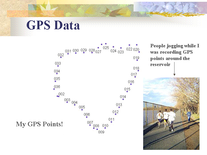
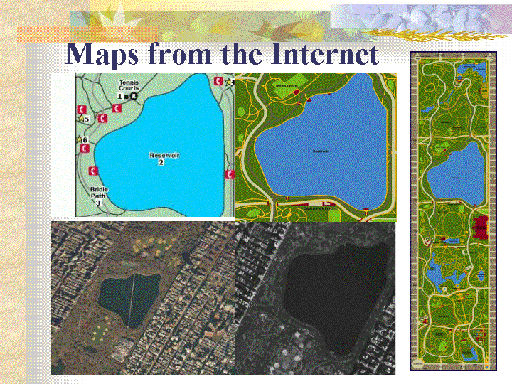
Figure 2. is a collection of the varied
maps of the reservoir that were acquired from the Internet.
Fig 2. Various maps of the Reservoir
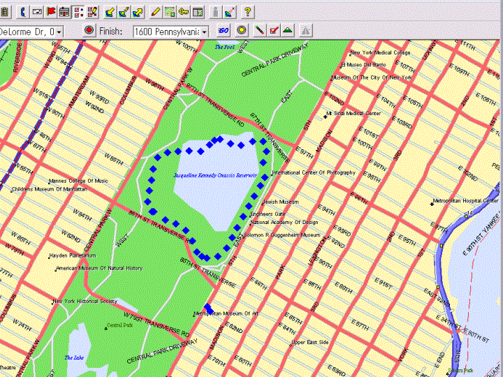
The first overlay analysis was conducted in USA Street Atlas. Figure 3. shows the GPS points that were directly
downloaded to the USA Street Atlas.
Fig 3. First Overlay in USA Street Atlas
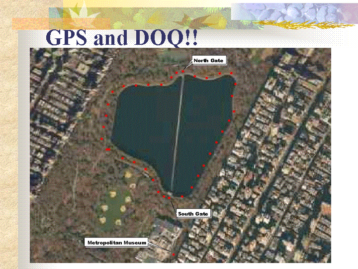
The second overlay analysis was conducted in ArcView 3.2.
The projection of the original GPS data (UTM NAD27)was transformed to UTM
NAD83 to adjust it's projection to the DOQ that was used as a base map.
Figure 4. shows how the GPS points overlaid
with the DOQ.
Fig 4. Second Overlay in ArcView
DISCUSSION
The GPS points on the first overlay are very far away from the
reservoir boundary depicted on the picture in the Street Atlas. On the other
hand, GPS points on the second overlay are very close to the reservoir boundary
that is shown on the DOQ image. Sources of error for the GPS data may include
atmospheric interference and therefore delayed and insufficient spatial
information received from the satellites. However, GPS and DOQs are probably the
most reliable and accurate data sources among all others. It’s probably now a
challenging debate to compare the effectiveness and efficiency between GPS and
DOQ data because they both have advantages and disadvantages. Possible
advantages of using GPS data are infinite resolution, exceeds national map
accuracy standard and low in cost. However, GPS may also have disadvantages
including missed information due to equipment failure and its slow and
labor-intensive nature. DOQs, on the other hand, can depict spatial features of
large areas very quickly and meets the national map accuracy standards. However,
some disadvantages are that they are extremely costly and small and detailed
spatial features may not be detected on the image by human eyes.
CONCLUSION
My original goal was to conduct various overlay analysis to perform a
thorough comparison between the accuracy and effectiveness of different data
sources including GPS data and DOQs. However, the overlay analysis and the
cross-examination of the data quality between different data sources were only
limited to two in this project due to various reasons. First, it was very
difficult to acquire projected data that was easily exported to ArcView to
conduct overlay analysis. Data acquisition over the Internet certainly required
a lot of time, effort and tremendous amount of luck. The other reason for the
insufficient overlay analysis was my limited knowledge on projection. I could
have performed more overlays if I could project unprojected JPEG images that
were available over the Internet. Understanding more about projections and the
software itself would be helpful to proceed and expand my studies in the future.