Geography 26 Project Papers: Spring 2002
|
Global Positioning System (GPS) Accuracy:
Differences in Vernal Pool Boundaries using the Garmin 12 XL and the Trimble Pro XR
|
Crystal Schmidt
Geography 26: Data Acquisition
American River College
|
Abstract
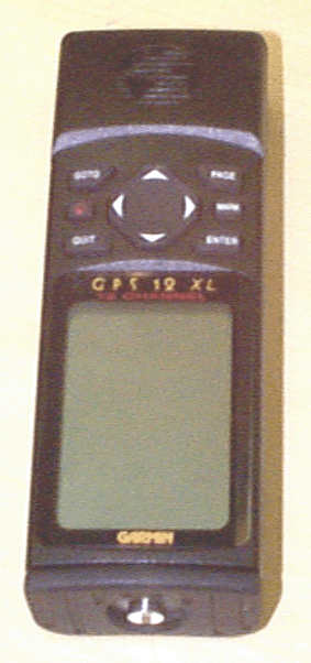
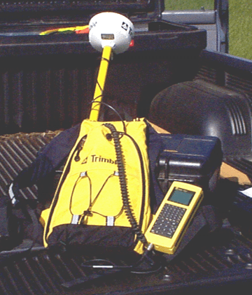
The Garmin 12 XL and the Trimble Pro XR are both Global Positioning Systems (GPS) units but seem to have different functions. The Garmin 12 XL is used, I believe, more for recreational uses. It is a cheaper GPS unit and it is small and easy to use. It is great to bring it out when you are canoeing, or hiking. It can also help to find your way back to a particular location if you got lost. The Trimble, on the other hand, costs around twelve thousand dollars and it is a bigger unit with many different attachment to piece together. The plus with the Trimble is the accuracy. The Trimble Pro XR comes to within three feet of it actual location. The main focus of this paper is to actually see the difference between the two GPS units.
Introduction
Global Positioning System (GPS) units vary in accuracy. The more accurate the GPS unit is, of course, the more expensive. For most mapping purposes, companies, even small companies, need high accuracy for the ability to measure distances from the particular GPS location. People viewing maps with point locations, normally tend to think that is the definite location on earth when in reality the location could be 20 meters away. For more of a recreational use, a fairy cheap GPS unit could be purchased to allow the user to find a general location of where he/she has been or wants to go. The accuracy may be a huge factor when deciding which GPS unit to purchase. This paper will focus on the accuracy differences between the Garmin 12 XL and the Trimble Pro XR. The area of interest that was GPS were three random vernal pools on a property in Sacramento County. The 80 acre property has been devoted to preservation to monitor the naturally occurring vernal pools.
Background
* GPS Units
In comparing the Garmin 12 XL to the Trimble Pro XR, further research had to be done to know the capabilities of each unit. To find out information on the Garmin 12 XL I used the website: (Online Marine, 1997-2000) , and for information on the Trimble Pro XR I used: (Seilerinst, 1999-2000) .
The standard package for the Garmin 12 XL is:
|
|
|
|
- A 12 Parallel Channel 12XL Reciever
- Built in Antenna
- 4 AA Alkaline Batteries
- Wrist Strap
- Carrying Case
The Garmin 12 XL Data Collector and System Specifications are:
- Size of Data Collector: 6.15"x2"x1.23"
- Weight: .79 lbs with Batteries
- Display: 2.2"x1.5", High Contrast LCD with Electo-Luminescent Backlighting
- Accuracy: 15 Meters (49 Feet) RMS, 1-5 Meters with Garmin GBR 21 Differential Receiver
The standard package for the Trimble Pro XR is:
|
|
|
|
- A 12 Parallel Channel Integrated GPS/ Beacon Reciever
- Integrated GPS/ Beacon Antenna
- 3 Meter Antenna Cable
- TDC1 or TSC1 Data Collector
- Base/ Rover Datalogging Modes
- 4 Rechargeable System Batteries
- Battery Charger and AC Power Supply
- Ergonomic Backpack Carrying System
- NMEA Output
- RTCM Input/ Output
- GPS Pathfinder Office Software
The Trimble Pro XR Data Collector and System Specifications are:
- Size of Data Collector: 8.2"x3.2"x1.75"
- Weight: 1.41 lbs with Batteries
- Display: 8 Lines x 20 Characters, Backlit superwist LCD
- Accuracy: " The accuracy of the ProXR receiver without real-time or postprocessed differential correction is 100 meters (2dRMS). After differential correction, the accuracy of each position is better than 75 cm (RMS + 1 part-per-million (ppm) times the distance between the base and the rover." (Trimble Navigation Limited, 1996)
* Vernal Pools
There are many reasons why I chose to GPS vernal pools. The main reason was, I did not know much about them. With a little research, I found out that vernal pools are actually depressions in the Earth, which hold water during the winter. The reason they hold water is the geology below the surface. Vernal pools have "...impermeable layers such as a hardpan, claypan, or volcanic basalt." (SJC RCD,2002) , which keeps the water in the pools rather than having the water seep directly through the soil. Along with the millions of year old geology, there are an array of plant and animal species that live in the vernal pools. These plants and animals live through severe conditions. In the winter, vernal pools fill and drain many times through the season. In the summer, the pools dry up leaving the seeds of the plant species and cysts from the animal species to try and survive in the hot weather. The next winter, the species will then grow and reproduce which is why you see a wide variety of flowers in the spring, in and around the vernal pools. (Fristrom and Game,2000) (EPA,2001) (CNPS,2002) (SJC RCD,2002)
Vernal pools, as the CERES website says, used to be used by Native Americans. In the winter months Native Americans, as historians believe, ate the plants and flowers that grow in the vernal pools. The website says that the roots of the Coyote Thistle resembles the modern day carrot. It is also said that, "Vernal pools were used for girl's initiation ceremonies, during which girls would festoon themselves with flowers from the pools and dance for several days." Vernal pool plants are also being used to test and develop new forms of medicines and pharmaceutical compounds.(SJC RCD,2002)
Methods
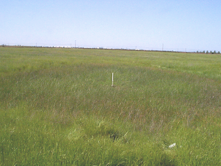
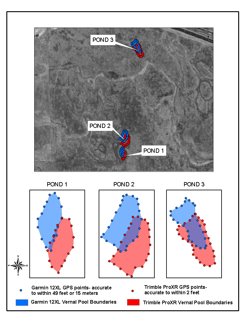
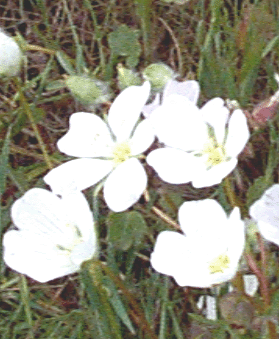
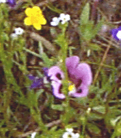
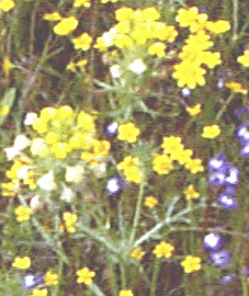
When trying to GPS vernal pools, people soon find that vernal pools do not have distinct boundaries. I had to use the change in vegetation as an indicator of the boundaries of the pools. Vernal pools can be home to a variety of plant and animal species. Approximately 200 different plant species have been known to grow in vernal pools. Each pool only houses around 15- 20 plant species each. A few species that I used to identify the vernal pool boundaries, and are also well known to grow in vernal pools are the Checkerbloom, Fremont's Tidy-tips, Vernal Pool Monkeyflower, Spokepod,and Vernal Pool Goldfields (yellow), Downingia (purple), and Vasey's Coyote-thistle (green). In deeper pools, such as ones I encountered, a brownish plant species grows, which is called Pale Spikerush. Also see Figure 1
To GPS, it took around 2 hours to actually find the vernal pools I wanted to GPS, set up the equipment for the Trimble, GPS, and take digital pictures. Each vernal pool was marked with a white pole in the center to measure the water levels of the pools. It was a clear, warm day in April 2002, and I had full satellites in range on the Garmin and on the Trimble. A co-worker came out to the property with me and handled the Trimble GPS. She is more familiar with the Trimble and I am more familiar with the Garmin, so I welcomed her help. The Trimble Pro XR unit also has the capabilities of differential correction which the Garmin 12 XL, I used, did not.
The best definition of Differential GPS (DGPS) Correction I found to help explain what exactly it is, is:
" DGPS employs two or more receivers. One receiver, called the base station, is placed at a known point to determine the errors in the psuedoranges to the satellites. An unlimited number of other mobile receivers, called rovers, collect data at unknown locations within the vicinity. The base station receiver computes corrections. These corrections are based on the differences between the actual and observed ranges to the tracked satellites. The psuedorange corrections (PRC) are based on these differences. The coordinates of the rover receivers are then computed by applying the PRCs to the observed ranges in real time." (Trimble Navigation Limited, 1996)
Once I decided what I thought was the boundary of the vernal pool, I stood in one spot for approximately 20-30 seconds, averaged twice and then saved the waypoint in the Garmin 12 XL. My co-worker with the Trimble Pro XR stood in the same spot I previously was (there was foot depression in the grass) and took a GPS point. Then I moved a foot or two down around the edge of the pool and repeated waiting 20-30 seconds, averaging twice and then saving. We continued like this around the entire pool until we had created a boundary. On the first vernal pool we GPS, we took 16 GPS points, at the second, 21 GPS points, and at the third, 24 GPS points. Each vernal pool was a different size therefore there was a different number of GPS points taken.
Figure 1- The second vernal pool that was GPS:
|
|
 |
|
Downloading the Garmin and Trimble data:
Downloading, displaying, and projecting the Garmin 12 XL GPS points was not as easy as I thought it would be. I used Waypoints + to download the Garmin GPS points. Most of the data I deal with is in North American Datum 1927 (NAD27), California State Plane (CSP) and in this case for Sacramento County, Zone 2. Therefore, in Waypoints+ I changed the datum to North American 1927 Mean and changed to configuration to decimal degrees. I then saved the points as a comma delimited text file. The problem arose when bringing the data into ArcView and projecting the data. I tried three different ways:
First:
I added the comma delimited text file into the tables in ArcView. In the view, I added an event theme. The data showed up fine and I projected the data into NAD27 CSP Zone 2 with the Projector! extension. Later I found out that the Projector! extension has had problems and it is not the best to use.
Second:
I tried the AVGarmin extension. I projected the Garmin GPS points into Teale Albers with the AVGarmin extension. I then used the Projector! extension to project the GPS points from Teale Albers into NAD27 CSP Zone 2, again, not knowing the problems with the extension.
Third:
I tried to bring in and project the points in ArcGIS 8.1 . I didn't find a way to add the comma delimited text file into ArcMap so I brought the *.txt file into Excel. I formatted the coordinates cells to be numbers with 10 decimal places. Then I saved the file as a dbase4. In ArcMap, I changed the Data Frame Properties coordinate system to NAD27 CSP Zone 2. Under Tools, I added XY data, and gave the GPS points the coordinates they are in Geographic- North American Datum 1927. When I added the new file in it said that it would have to project the data on the fly because they were in different coordinate systems. I said ok and then I right clicked on the file and did data-export. I exported the points the same as the Data Frame which was NAD27 CSP Zone 2.
I did not know which of these three methods was more accurate so I brought them all into ArcView. They all seemed to be in the same location. I printed out the tables for each method and noticed that the coordinates were the same except after the decimal place. I decided to use the AVGarmin points in the rest of my analysis.
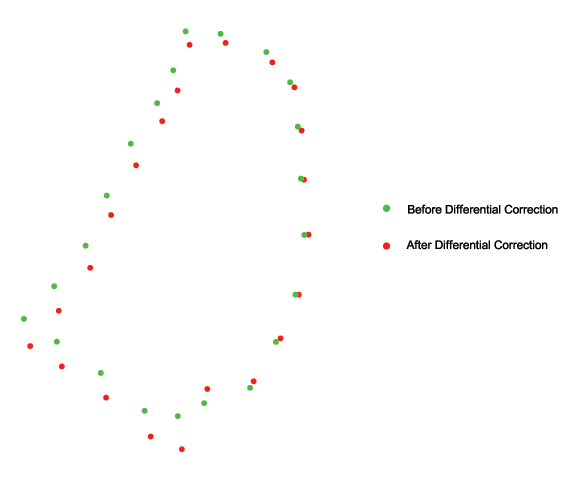
After viewing the three tables I decided to download the Trimble GPS points. Downloading the GPS points from the Trimble data collector to Pathfinder Office software was relatively easy. Directly from the data collector into Pathfinder Office and projecting the data into NAD27 CSP Zone 2, which is an option when downloading the data, I exported that data as a shapefile. Then I ran a differential correction on those GPS points. I used the Sacramento GPS Community Base Station website to correct the files. The base station is at USDS Forest Service, Remote Sensing Lab 1920 20th street downtown. I then exported the corrected points as a shapefile also. I was interested in seeing how much the differential correction actually moved the original points.
Figure 2- Trimble GPS points at the second vernal pool, before and after differential correction:
|
|
 |
|
Differential correction comes with the Trimble ProXR package so I decided to use the differentially corrected GPS points for the remainder of my analysis.
Results
I brought the AVGarmin points and the Trimble differentially corrected points into ArcGIS- ArcMap. To better view what I was looking at I connected the Garmin points at each pool to make a polygon or area, to see the boundaries. I did the same for the Trimble points. I made the polygons slightly transparent so I could view the overlap. I also brought in a scanned image that was rectified to the parcels boundaries.
Figure 5: Garmin and Trimble GPS Points
|
|
 |
|
Analysis
I noticed that there seemed to be a North West shift in the Garmin GPS points compared to the Trimble. I was concerned about this so I brought both the Garmin and the Trimble GPS points into AutoCAD Map. I wanted to measure the length and the angle between the Garmin and the Trimble at the same locations. I thought if all the lengths and angles were the same that there might be a projection issue.
At GPS point 026 the length between the two was 35.9' and at 117 degrees. At GPS point 034 the length was 37.2' and at 107 degrees. At GPS point 037 the length was 39.3' and at 113 degrees.
The lengths and angles were close but not the same, but I still believe that there is something wrong when projecting the Garmin data into NAD27 CSP Zone 2. I only had time to test the second vernal pool that we GPS and at only three points. Further analysis will have to be done at a later time.
Conclusion
In comparing the Garmin 12XL to the Trimble ProXR, it is my opinion that it is up to the consumer to decide what kind of accuracy they need and how much they want to spend to achieve that accuracy. In most cases, the better the accuracy, the more the cost of the unit. You can have accuracy of 49 feet like the Garmin and pay a couple hundred dollars or accuracy of 3 feet like the Trimble and pay a approximately twelve thousand dollars. I personally think the Garmin is great for recreational uses such as backpacking, mountain biking, or teaching a class how to use a GPS unit. For companies producing maps, it is important that they produce the most accurate map they can. As I have said before, some people viewing maps with point locations on them tend to think that is the definite location on earth. In actuality the location could be 20 to even 100 meters away. I believe the Trimble ProXR is easy to learn and use and produces a really close location to reality.
References
(Online Marine, 1997-2000) Online Marine, Garmin GPS 12XL, 1997-2000.
http://www.onlinemarine.com/cgi-local/SoftCart.exe/online_superstore/electronics/gps/gps12xl.htm?L+scstore+dmjz6327ff950e95+1022314005
(Seilerinst, 1999-2000) Trimble Navigation Limited, GPS Pathfinder Pro XR/XRS, 1999-2000.
http://www.seilerinst.com/gps/products/pdfs/pthproxr.pdf
Trimble Navigation Limited, Pro XR Receiver Manual, October 1996.
(SJC RCD, 2002) San Joaquin County Resource Conservation District, Vernal Pools: Their History and Status in California's Central Valley, January 17, 2002.
http://ceres.ca.gov/wetlands/whats_new/vernal_sjq.html
(Fristrom and Game, 2000) California Native Plant Society, Vernal Pools: A Vanishing Habititat, Dianne Fristrom and John Game, 2000.
http://www.cnps.org/gallery/fristrom2/vernalpools.htm
(EPA, 2001): Environmental Protection Agency, Vernal Pools, May 09, 2001.
http://www.epa.gov/owow/wetlands/types/vernal.html
(CNPS,2002): California Native Plant Society, Mather Field Vernal Pools- Preservation Campaign, Febuary 17, 2002.
http://www.cnpssacvalley.org/mather.html
| | | |