| Granite Bay Horse Trail: A GPS and GIS Project | |
|
Author Name: Larelle Burkham-Greydanus American River College, Geography 26: Data Acquisition in GIS: Fall 2002 | |
|
Abstract This paper discusses methodolgy, comparision, analysis, and conclusion of a project using current and newly GPS/GIS maps of the Folsom Lake Horse Trail in Granite Bay, California | |
|
Introduction Finding a horse back riding trail in an unfamiliar area can be an adventure within itself even when it is near a safer known urban area such as Folsom Lake, California. Often times a rider must rely on a friend to physically guide them on the trail. This trail knowledge is usually just handed down through one rider to another without consideration of a good map. And even with a guide, the full course of the trail and its' multitude of dangerous areas would be limited by the guides knowledge. Various problems on a horse trail include lack of general signage, and marking adjacent restrictive area (private property) boundaries. As a result, accidents can and do occur, such as riding into downed, hidden barbed wire fences on unmaked private property. The current maps of Folsom Lake Horse Trail (also known as the Pioneer Express Trail) are not as accurate as one would hope for riding safety. Producing a new trail map will be attempted in this project. A GPS unit will be used for establishing way points and trackpoints initially to designate the accurate trail. Then this trail will be compared to current maps and placed upon the backdrop of a U.S.G.S. quad (24K) for georeferencing. | |
|
Background This project was designed by the author with her and her horse back riding friends safety in mind. As the project developed, another idea was generated to address the project as if the final map and findings would be sent to the Department of Parks and Recreation. This would include a justification and request to improve their kisok maps and post a new map on their website. | |
|
Methodology Survey Area Criteria: Conditions and Characteristics: The survey took place along the Pioneer Express Horse Trail out of the Granite Bay Horse Staging on Folsom Lake, California on November 3rd and 17th, 2002. The direction was heading northeast on the Pioneer/Pony Express Trail towards Auburn, California. The length was actually 1.5 miles which took 1 hour and 15 minutes to complete (roundtrip) on horseback and 2 hours to complete on foot. Elevation changes were from 400 feet to 600 feet. The GPS unit used was a Garmin, Personal Navigator, XL12. The environment around the trail did not appear to have anything present to hamper the signals for the GPS unit to receive a continuous signal for the trackpoints. The trail comprised primarily of dirt, sand and granite rocks. There were trees and shrubs present as seen in a oak wooded environment. The Garmin GPS unit was set to make a track point every 5 seconds. This was the lowest time interval able to obtain on the unit. An attempt was made during the first trial to collect a trackpoint every .2 miles (the lowest on the Garmin unit) and this was felt to create too low an accuracy for the trail. Waypoints were made at the staging area, trail head, and at State Park trail markers. The trail markers were greatly lacking as seen in the final map. | |
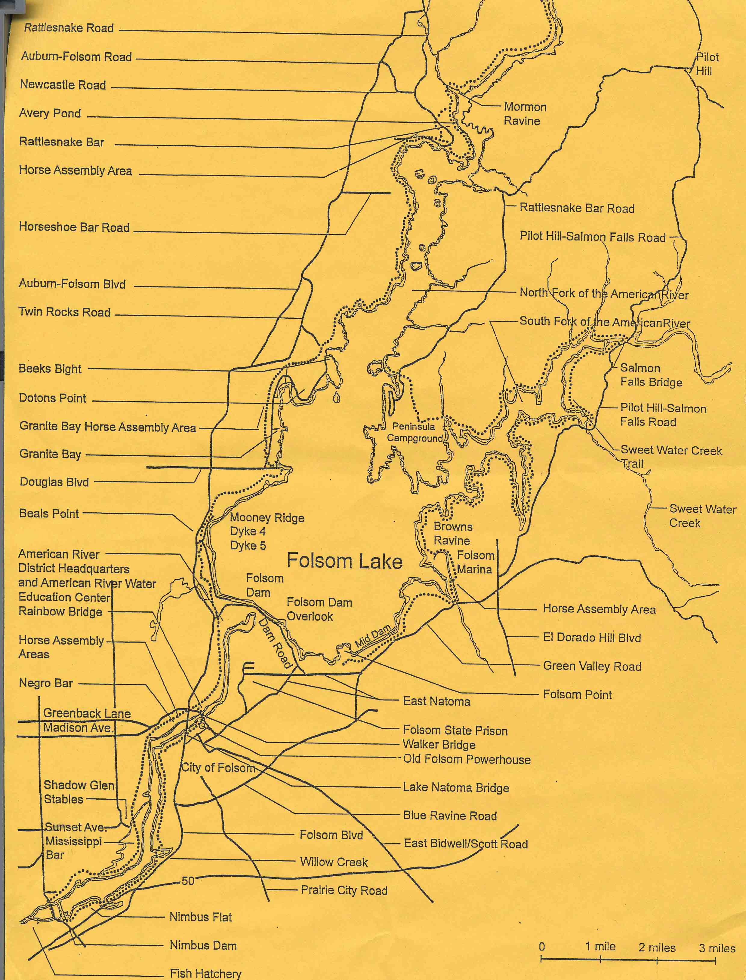
Accuracy was to be determined by location of waypoints to intersection streets, trailheads
staging areas, and obvious trail changes between the only 4 maps available. The first two are from the Beals Point Folsom
Lake State Park kiosk. The last is from Douglas Ranch Supply in Granite Bay and is considered currently the most accurate
map of the horse trail.
   | |
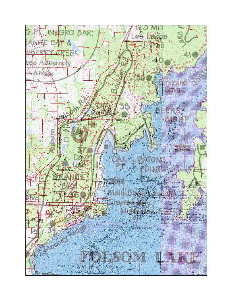
Once the waypoints and trackpoints were collected, they were down loaded to Arc View 3.2
from the GPS unit using the Waypoints program and a special track point for downloading program from Department of Fish And Game. The points were placed upon the Quads that had previously
had a transparent layer of the Folsom Lake Trail Patrol placed upon them. This map was georeferenced using ArcMap 8.0 onto the quads using over 30 points. A GDT layer was also placed just
for the Granite Bay portion of the map to confirm roads compared to the possibly old road on the Granite Bay quad.
 | |
|
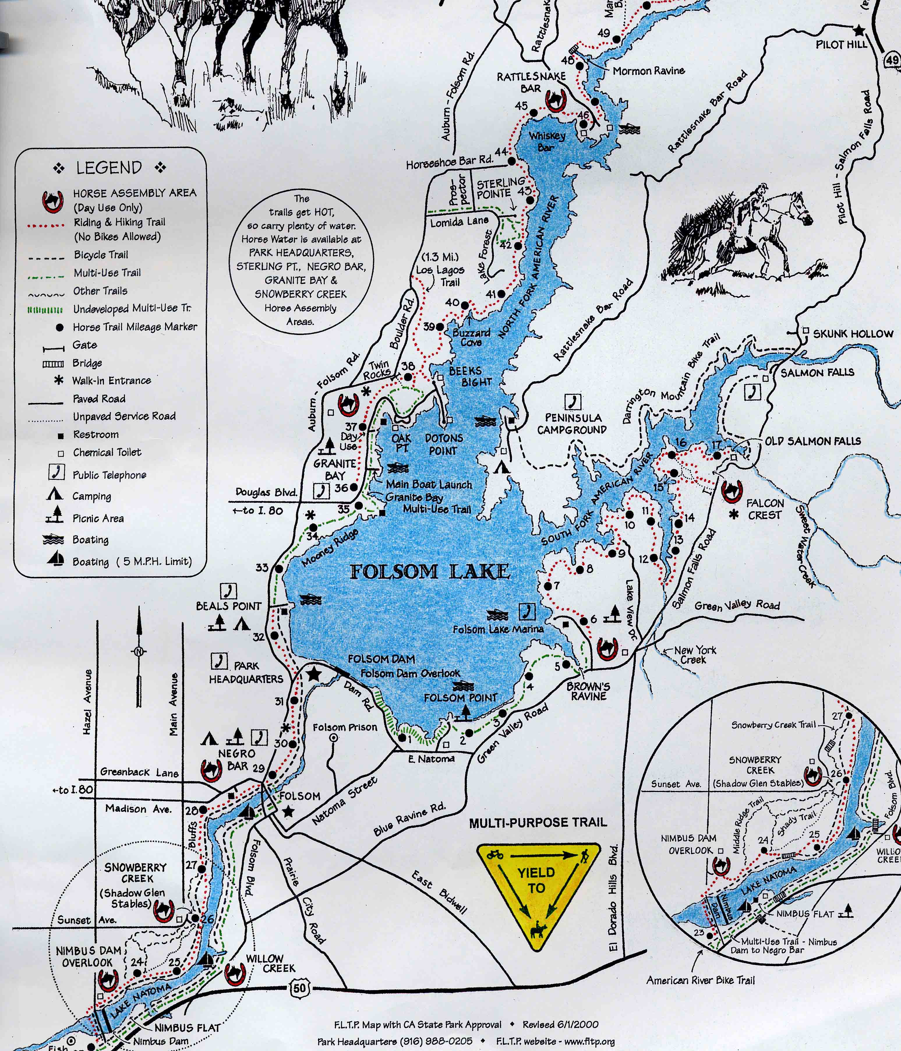
Analysis The two maps from the kiosk were the least accurate with regards to the
horse trail. It appeared that the maps were just for general hiking and landmark references. The Folsom Lake Trail Patrol
map compared to the GPS trail appeared to be about 80% correct. It was difficult to compare some of the waypoints
on the trial patrol map because the legend used a very large horseshoe with horsehead to represent the staging area.
Another waypoint for accuracy was when the horse trail opened up to a gravel road (used only by park employees by car). Just across this road was a waypoint trail marker for the horse trail and another marker for the bike trail approximately 30 feet away. When you make a left at this intersection of gravel road, bike,and horse trail there is a second staging area present. The GPS trail was correct, but the Patrol Trail map was not. Another area considered for accuracy was where the Los Lagos Horse Trail intersected the GPS horse trail. It appeared that Patrol Trail coincides and runs along side of the Los Lagos trail (incorrectly), but the GPS trail correctly intersects it. The last accuracy comparision was attempted using the "Lookout" point by Beeks Point which is at the hight elevation for this portion of trail. The waypoint at the "LookOut" (and the end of this leg) was observed on the highest elevation marking on the Quad. However, the Patrol Trail does not come near the "Lookout" | |
|
Final Map 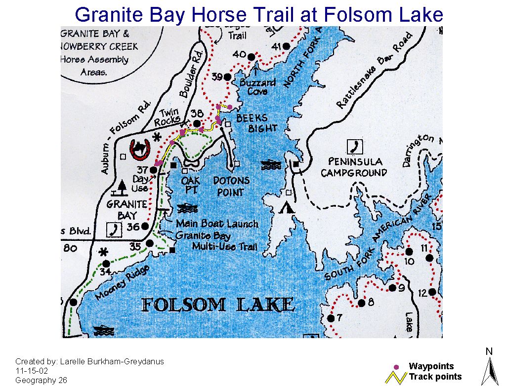 |
Conclusions Multiple problems occured with this project from the method of transportation used
to collect waypoints, to the use of the first .jpg image in the webpage. Mapping programs had to be changed from ArcView
to ArcMap to make a transparency layer for georeferencing and the final map. Also, there was an intial desire to GPS a greater
portion of the Folsom Lake Horse Trail, but that proved to be too large an area (over 25 miles). Many more waypoints should have been taken and accompanied tally sheet used to simultaneoulsy identify all points with a legend. For example, unusual rock formations, creeks, and small areas of severe trail erosion could be placed on the map for safety landmarks. Buffer areas on the ArcView program could be used to show the possible error of the GPS unit (possibly 10 meters). Lastly, an improved final map with a better legend and marginallia could be used especially, if formally presenting to the State Department of Parks and Recreation as a justification request for a better map. And lines could have been drawn to highlight specific areas discussed on the .jpg map images |
|
References
Maps of Folsom Lake 1 and 2, California Department of Parks and Recreation, (no author, date, or titles) Folsom Lake Trail Patrol Map, Folsom Lake Trail Patrol, (no author, date, or titles) | |