USING GIS TO ANALYZE NONFICTION LITERATURE
Author
Information
ALVIN COLPITTS
American River College, Geography 26: Data
Acquisition in GIS; Fall 2002
Abstract
I sit at my desk
each night with no place to go,
opening the wrinkled maps of Milwaukee and Buffalo,
the whole U.S.,
its cemeteries, its arbitrary time zones,
through routes like small
veins, capitals like small stones.
~ Anne Sexton
A hallmark of
good writing is an ability to “transport” the reader to an intended place or
time. Literary works abound with passages which attempt to define space and
time. In fiction, the writer may have an actual place in mind which gives form
to the physical landscape, but artistic license allows for alteration. For the
nonfiction writer, however, place and space must be definite. Their work must be
able to convey precise, verifiable visual images to the audience.
Often,
as an aid to spatial understanding, publishers supplement nonfiction with maps.
Readers are given a basic lay of the land with features, it is hoped, will help
them in their comprehension of the text material. Sometimes the maps are
sufficient. In many cases, if not most, they seem to be woefully inadequate.
Introduction
My project is an attempt to use the tools of GIS
to promote a better understanding of a specific place in a nonfiction work. I
was first struck by the dearth of spatial information presented by supplied maps
while reading J. M. Roberts’ thorough and informative History of the World
(Penguin Books). Fascinated - sometimes overwhelmed - by the density of
information presented, I was somewhat frustrated by the lack of support supplied
by the accompanying maps distributed throughout the pages. Inadequate legends.
Cramped labels. Is that supposed to be a river or a national border? Eventually,
I abandoned referring to the maps altogether.
A nascent understanding of
GIS has led me to consider ways in which this technology can enhance nonfiction
literature. Surely, better maps can enlighten the reader, but I began to wonder
if the application of GIS to the process would yield greater results. Challenged
by the possibilities (I have yet to find anything that discusses a GIS treatment
of literature), I set my wheels in motion.
Background
My next
task was to determine a source for the project. What book should I develop the
map from? I wanted to choose a piece which would allow me to explore a place -
or places - that I had never been to before. I desired to learn about an area of
the country I was not familiar with. I figured this factor would add a measure
of intrigue to the task. After much consideration, I settled on William Least
Heat Moon’s Blue Highways. Published in 1983, the book recounts the author’s
solo trek around the United States. Keeping primarily to backroads (the “blue”
highways on old highway maps) rather than interstates, Heat Moon takes 3 months
to round the country, traveling over 13,000 miles and visiting 39 states ( by my
count). My wife and I had read the book together on a road trip from Southern
California to Bryce Canyon National Park and back. We were captivated by the
author’s tales of obscure little places with names like Nameless (Tennessee),
Dime Box (Texas), Hungry Horse (Montana) and Humptulips (Washington). The
romantic in me swelled with visions of cross-country travel to similar
off-the-beaten-path locales. The piece was chosen for another, more pertinent,
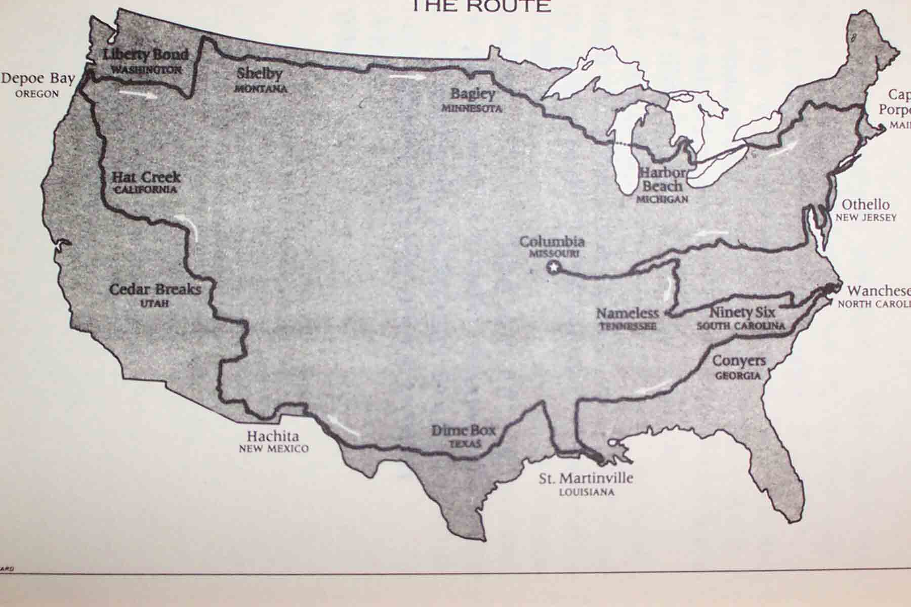
reason: there was only one map in the entire book. One map!
And not a very good one, as you can see. We were
fortunate to have our road atlas with us, but it was lacking somewhat as well.
“Where exactly is The Palouse?”, I remember my wife asking, as we read of the
author’s travels through eastern Washington. I shrugged. “ I don’t know. I
thought that was the name of Washington State’s football stadium”, I replied. My
initial intent was to create a map sketching each blue highway Heat Moon drove
along. Within each line segment, I would locate points representing the various
towns and other landmarks he had mentioned with references to their respective
page numbers.
As I began creating the database from the book’s index, I
realized the immensity of the task I’d undertaken. A quick count indicated there
were more than 500 point locations mentioned by name. Coupled with 13,000 road
miles, my construct, I concluded, was going to be far more complex than anything
I could handle in one semester. I would have to scale the project back. I
decided to focus on only one state.
If you are what you eat,
a visit to North Carolina could
make you a very interesting person.
~ North Carolina Travel Dept.
I quickly settled on North Carolina. For reasons that are hard to
identify, let alone explain, the Tar Heel State has always held me in thrall.
With a 4-year old and a newborn (2 weeks new when we’d left Southern
California!) in tow, we had set off this past spring on a six-week RV trip
across the country. We reached our eastern culminate with a one-week stay in
Asheville, exploring the western part of the state.
I was pleased to
discover I had not crossed paths with Heat Moon. This met my condition that I
had not been to the place I would be studying. Entering North Carolina from
Tennessee on Rte. 321, he spends almost 50 pages touring the eastern half before
exiting for South Carolina on SC Hwy. 34.
Again, I became concerned
about the scope of my study. Could I prepare a quality GIS-based examination of
so great an area? A key feature of GIS is an ability to deliver depth to spatial
analysis. I feared I would not be able to do so within the alotted time. For the
sake of maintaining peace of mind, I decided to narrow my subject once again.
The first third of the North Carolina narrative is indistinguishable in
its discussion of place. Mainly, it is about the author searching for a dead
relative’s burial place. On page 89, however, I began to sense I was on to
something:
Out of Greenville, on Route 32 just northeast of the road
to Pinetown, gulls dropped in behind the
Farmalls and poked over the
upturned soil for bugs, and the east wind carried in the smell of the
sea.
People here call the dark earth “the blacklands”. Scraping, scalping,
bulldozers were clearing fields for tobacco and pushing
the pines into big
tumuli; as the trees burned, the seawind blew smoke from the balefires down
along the highway
like groundfog. Trees burned so tobacco could grow so
tobacco could burn. But where great conifers still stood,
they cast
three-hundred-foot shadows through the morning, and the cool air smelled of
balsam… (89-90)
Studying a reference map I had recently ordered
online - courtesy of the North Carolina Dept. of Transportation - I picked up
the author’s scent on NC State Road 32 (out of Washington, NC actually) and
navigated over the narrative. SR-32 brought us into Plymouth, where we filled
the tank and conversed with an old-timer about timber, tobacco and The War
Between the States (90-92). Out of Plymouth, we headed east on State Hwy. 64 and
onto the tidewater peninsula which sits between Albemarle Sound on the north and
the Pamlico River to the south. I was taken with how my map had brought out the
text:
Cypress trees cooling their giant butts in clean swamp
water black from the tannin in their roots, the
road running straight and
level and bounded on each side by watery “borrow ditches” that furnished soil to
build
the roadway. Ditches, road, trees - all at right angles. The swamp
growth was too thick to paddle a greased canoe
through, and, although
leafless, the dense limbs left the swamp without sun.
Then, precipitately,
the vegetable walls stopped, and the wide Alligator River estuary opened
to
sky and wind. Whitecaps broke out of the strange burgundy water. As I
drove the long bridge over the inlet, a herring gull,
a glare of feathers,
put a wingtip a few feet to the left of Ghost Dancing (the handle given by the
author to the
Ford Econoline), and, wings steady, accompanied me across. (92)
Crossing the Alligator, I determined, had brought me at last
to my destination: Dare County. Consisting of a mainland
peninsula-within-a-peninsula, an island (Roanoke) and a section of a unique
stretch of land commonly known as the Outer Banks, I felt Dare County presented
myriad opportunities for a GIS project. I wasn’t sure of what I would do, but
now, at least, I knew where I would do it.
Methods
As
previously mentioned, there is no specific instance - that I was able to find -
where someone has discussed using the tools of GIS to develop mapping strategies
for a specific piece of nonfiction literature. Inherent to the basic nature of
GIS is the need to deal with fact. This would rule out its use with fiction,
naturally; though I suppose perhaps someone with an extremely creative mind
could use the technology to create maps for a non-existent place. George Lucas,
the creator of Star Wars, comes to mind as a possible candidate.
I did,
however, come across a book, which examined how GIS is being used to study
history - the lifeblood of most, if not all, nonfiction. Past Time, Past Place:
GIS for History (Knowles, ed. 2002) catalogues a dozen cases in which the
technology is being utilized to enhance our understanding of the past. Topics as
wide-ranging as the Salem Witch Trials, the Civil War and the Depression-era
Dust Bowl phenomenon are given modern-era treatment using the tools provided by
GIS. Historical maps are given over to rubber sheeting, static data sets are
presented in a geospatial arrangement and data-gathering capabilities, primarily
GPS systems, are used to pinpoint features which may have been obscured by the
passing of time.
The case studies, I felt, closely paralleled what I was
trying to do. In his geospatial analysis of New York City census data for
factors of race, immigration and ethnicity throughout the 20th century, Andrew
Beveridge makes reference in passing to Jacob Riis’1890 landmark sociological
study, How the Other Half Lives (p.75). Here, Riis examined conditions in which
the poorest classes of people survived in New York City as well. I’m certain a
fusion with Beveridge’s GIS output would yield insights into How the Other Half
Lives not otherwise possible.
My embarkation point, however, differs
somewhat from those in Past Time, Past Place. As a travel narrative, Blue
Highways is not really about an historic event - though it is historical (I date
the trip at some time between 1975 and 1983). I’ve often wondered what Heat Moon
would think of my attempt to quantify his experience. Well, whatever his
opinion, I soon came to the realization that no amount of time searching the Web
was going to yield a database file of his journey. The book would just have to
fill this requirement. And, the “geoprocessing wizard” that I am, that theme had
just been clipped by a Dare County shapefile!
I knew at once my focus
would be on the Outer Banks. How peculiar this landform that rims the coastline?
Running from the Virginia south for some 175 miles, the strand maybe reaches two
miles across at its widest point. The Outer Banks are home to Kitty Hawk. Much
of the Banks compose the Cape Hatteras National Seashore, one of the nation’s
more popular national parks. I set about learning their environmental
characteristics, endeavoring perchance to understand how the Outer Banks formed,
and how they continue to exist, given the frequent hurricanes which batter the
Atlantic Coast.
Additionally, I began investigating those magnificent
sentries of the Outer Banks - the lighthouses. If time permitted, I wanted to
create “hot links” in Arc View, which would allow viewers to click on an icon
for live views from the respective lighthouses. I considered attempting to
create a GIS model of the moving of the Cape Hatteras lighthouse in 1999. The
208-foot giant was moved 2,900 feet inland because it was feared that further
erosion might topple the structure into the surf (note: originally built in
1870, the monolithic-like structure was 1,500 feet from the water at that time!)
Unfortunately, my grand plans were thwarted by the realization that Heat
Moon never visits the Outer Banks. Sure, he leaves the mainland and heads toward
my Shangri-La, but he only goes as far as Roanoke Island (say it ain’t so!)…
Two roads diverged in a yellow wood,
And sorry I could
not travel both
And be one traveler, long I stood
And looked down one as
far as I could
To where it bent in the undergrowth;
~ Robert Frost
I realized I had reached a crossroad. I could either devote myself
to continuing on the Banks or stay true to the text. I determined here the
project would be about the journey rather than the results. I felt it was more
important to stick with my original premise.
Feeling somewhat stranded
on Roanoke Island though, I began to look around. Heat Moon gives no explicit
reason for having come here, but through the pages I began to develop a fondness
for the place. The first English settlement in the New World, Fort Raleigh, was
established along the island’s north shore (Dare County, it is said, is named
after the first Anglo child born in the United States). Roanoke’s two formal
towns, Manteo and Wanchese, were named for the first two Manitowocs taken by the
explorers back to England to be trained as interpreters.
I began to
ponder. As a subject, the thought of analyzing an island sounded appealing. The
land-type has clearly defined boundaries, by nature. Points, lines and polygonal
features are abundant on a developed island like Roanoke. I hoped this would
mean data could be gathered quickly and efficiently in an easily definable
format. I was ready to go.
The fact I was 3,000 miles from my study area
would limit my access to data. My sole option, I felt, was to search the
Internet. I was able to download general shapefile and database data for Dare
County from the state’s Department of Transportation website (www.ncdot.org
). However, I had a great deal of difficulty finding a
shapefile which provided an outline of Roanoke . Moreover, when I did locate a
source for this essential component, my lack of ability with Arc View 3.2 meant
I wasn’t able to georeference the dataset with my existing one. Basically, the
outline of Roanoke Island was in eastern Tennessee!
At this point,
feeling the pressure of time constraints, I chose to scrap everything I had done
in Arc View up to this point. I thought I would be able to avoid repeating the
projection error issue by pulling all my data from the same location. I was
quite fortunate on this front. An orderly data dataset was accessed via the US
Census Bureau’s TIGER/ Line network.
Results
Analysis
I’m afraid I’ve fallen quite short on
this front. Due to the time factor and a general inability to master the tools
of Geographic Information Systems (for now!), I wasn’t truly able to bring about
a geospatial understanding to Blue Highways. I realize I spent far too much time
reading and deciding where to focus my attention, rather than quickly settling
the matter and moving on to data acquisition and analysis.
Hindsight has
also allowed me to consider how I might have treated Roanoke Island. Perhaps I
could have examined population trends in Manteo and Wanchese in the past 20-30
years since the book was written, or examined land-use issues unique to the
island. I had hoped this would be possible, as I found a map that defined the
marsh areas of Roanoke. There was, however, no accompanying dataset and I was
not able to incorporate the image into my Arc View session. Additionally,
knowing the software package more definitely would have allowed me to pinpoint
locations from the text material in the display. I had tried to do this by
indicating the position of Fort Raleigh on the island, but I wasn’t impressed
with the result.
Conclusion
Alas, this project has allowed
me to understand what needs to be considered in applying GIS technology to
nonfiction. Rather than being obsessed with determining where my analysis would
take place, I believe it is more important to look for what can be examined with
GIS. I am sure future projects in the GIS industry, similar to those chronicled
in Past Time, Past Place, will prove vital in our understanding of social
evolution.
Likewise, I hope that with greater understanding of GIS
applications, my desire to develop a model for narrative nonfiction will mature.
I truly sense based, on this research, that GIS can advance the quality of
cartographic output for print works. I’ve not yet resolved the issue of how to
deliver this vision in a broad format, but I’ll cross that bridge when I come to
it…
The man who says it can’t be done,
is interrupted by the
man doing it.
~ Unknown
(from a sticker on our refrigerator when I was a
kid)
References
DATA:
US Census TIGER/Line Files
QUOTES:
-All quotes were found at www.bartleby.com
Emerson,
Ralph Waldo “The Young American”: Nature, Addresses, and Lectures
(1849)
Referenced from The Columbia World of Quotations. 1996
Frost,
Robert “The Road Not Taken” from The Poetry of Robert Frost.
Henry Holt
& Co., 1920
Referenced from The Columbia World of Quotations.
1996
North Carolina Travel Department “If you are what you eat…” From
an
advertisement in Sports Illustrated, 31 Mar 1986
Referenced from
Simpson’s Contemporary Quotations. 1988
Sexton, Anne “And One for My Dame
(poem)”
Referenced from The Columbia World of Quotations.
1996
REFERENCES:
Heat Moon, William Least. Blue Highways. Hall &
Co. (Boston), 1983
Knowles, Kathleen (ed.) Past Time, Past Place: GIS in
History. ESRI Press, 2002