Title
Mapping Vernal Pools: A Study in Data Acquisition
Author Information
MaryEllen Komnath
American River College, Geography 26: Data Acquisition in GIS; Fall 2002
Contact Information (MaryEllen Komnath, 916-331-8810, email: mkomnath@wildlandsinc.com)
Abstract
This project will present data acquisition techniques used to map wetlands.
Introduction
Wildlands, Inc. is proposing the establishment of a mitigation/conservation bank on approximately 627 acres located in Solano County east of the City of Fairfield. The land is currently being used for cattle grazing and has been used historically for agricultural crops. The leveled Antioch-San Ysidro soils formerly used for irrigated agriculture provide excellent opportunity to restore and create vernal pool habitat. These soils comprise approximately 324 acres of the site. Naturally occurring pools are present on the site and are associated with the mound-intermound topography of the Solano loam soils. This area of naturally occuring pools provides a conservation bank component of approximately 259 acres. Restoration of 44 acres of brackish marsh habitat that occurs on a remnant of the Suisun Marsh is also proposed. However, restoration of this tidal influence is not feasible due to the blockage of the historic tidal channels.
This site provides an opportunity to restore and preserve wetland habitat such as vernal pools and seasonal wetland areas. Historic aerial photos, in addition to global positioning system data, biological surveys and soils information will provide guidance for restoring the natural vernal pool topography and hydrology of the site. This paper will exhibit the data acquisition techniques used by the Resource Ecologist and myself in evaluating and mapping the existing conditions of wetland habitat on the site.
Methods
I began my research, which consisted of mapping the vernal pools, by acquiring an aerial photo of the site. I contacted aerial photography companies requesting stock photography dated from January to April of any year at a scale of 1: 24000 or better. Four stock photos were available from various companies. Available years were 1992, 1988, 1982 and 1968. I then researched rainfall data for those years on the California Department of Water Resources web site. I selected the photo for 1992 based the its scale of 1: 8400, and on the rainfall data amounts for that year.
A preliminary field visit was scheduled to GPS, using a Trimble TSC 1 data collector,and to strategize future field mapping efforts. Using the TSC 1 GPS, site features and roads were GPS'd for aerial photo rectification. The aerial photos were then rectified using Arcview 3.2 Image Analysis to UTM Zone 10 to match existing data sets for that project. Once the photos were rectified, I heads up digitized a T-Post grid points layer over the site to help organize mapping efforts. A waypoint file of this grid was created and exported using Pathfinder 2.6 into the Trimble TSC1. Using the waypoint file, the T-Post were placed in the ground and labeled. The vernal pools and wetlands were then GPS'd as polygons. The swales were mapped as line features, and their width measured in feet. The swale line shapefile was then buffered to match the swale measured field distance and converted to polygons in Arcview. Data collection points were GPS'd for soil and plant sampling data. The point, line, and polygon field data was then downloaded, using Pathfinder, corrected, cleaned up, and exported into UTM Zone 10 into Arcview shapefiles to overlay with existing data. I completed this process at the end of each field day in order to update field crew maps for the following field day.
Results
There are five wetland feature types mapped at the site: vernal pools, smeared vernal pools, saline wetland, seasonal swale/seasonal wetland and vernal pool/seasonal wetland complex. Table 1 illustrates the feature types and acreages. Figure 1 shows the distribution of these wetland types. Smeared vernal pools are located mostly in the 324 acres of cultivated pastures. This area will serve as the restoration and creation area for vernal pools.The preservation component of the site will be the vernal pools, seasonal wetland complex that fall in the 259 acres of non-cultivated Solano loam soils. A further feasibility study of the 44 acres of saline wetland will determine whether this area will be restored. Continued mapping throughout the winter of 2003 will further define areas of preservation and restoration.

Table 1: Total Acreage of Wetlands
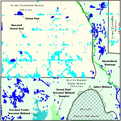
Figure 1: GPS Data Overlay on Existing Pastures.
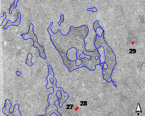
Figure 2: Close up of GPS Polygons and Data Collection Points.
Conclusion
GPS mapping at the site will continue throughout the winter and early spring of 2003 to confirm existing mapped features and to map new wetland features made more visible by rainfall. To assist in the winter mapping efforts a new color aerial photo will be flown when the vernal pools are full. New acreages and GPS data will be calculated and presented for management approval and a conceptual restoration and preservation plan will be designed and proposed for future land management of the property.
References
Aerial Photo Source: Pacific Aerial Surveys(HJW) April 3 1992
Precipitation: http://cdec.water.ca.gov/misc/MonthlyPrecip.html
USGS Topographic Map, Denverton Quad
U.S. Soil Conservation Service 1977 Soil Survey Solano County, California. Washington DC.
Personal Communication, Wildlands, Inc.
Teresa Bishop McGaffic, Geographic Analyst
Jeff Novak, Landscape Restoration Designer
John Ranlett, Resource Ecologist
Equipment
Trimble TSC1 Data Collector
Pathfinder Office 2.6
Arcview 3.2
Arcview Image Analysis 1.1