|
|
||
|
Carrie George American River College Geography 26: Data Acquisition in GIS Spring 2003 |
||
|
A
b s t r a c t
|
||
|
Acquiring data for projects that require a GIS component can cross the spectrum from easy to hair-brained. But once the data is in hand, whats to be done with it? Beyond the simply making maps or doing simple analysis, thought must be given to the timeframe of the data's usefulness. Acquiring data from in-ouse non-technical staff poses challenges in it's level of attribution and accuracy, not to mention making it work for a project. This excersice was intended to loosely run the process of project data acquisition for communication to non-technical staff in a "brown-bag" setting. |
||
|
I
n t r o d u c t i o n
|
||
| Obtaining
GIS data for any project can be at times a challenge. Coming into a project
well after it's inception can be an organizational mess. My previous GIS
work experience has been with a federal agency that takes great care in
data accuracy and standards while maintaining a base data archive containing
most everything GIS staff could ask for. Maintaining the base data "nuts
and bolts" thus makes other analysis easier. Moving into a private
sector job with a young GIS department creates new challenges in acquiring,
maintaining and paying for base data per individual project. Therefore,
the benefits GIS staff involvement early on in any project will only prove
to be beneficial in the months and years to come. Focusing on an ongoing
project in the South Lake Tahoe area, I will review the process of acquiring
data internally and externally to show varying degrees of acquirable data
and it's usefulness. |
||
|
B
a c k g r o u n d
|
||
|
The
Upper Truckee Marsha area lies at the southern end of Lake Tahoe, surrounded
by the town of South Lake Tahoe. Project staff are currently examining
the effects of urban encroachment on the marsh and its relationship
to impacts of municipal infrastructure. Previous to my involvement with
the Upper Truckee project, digital topoquads (DRG's) and some aerials
were obtained along with staff developed shapefiles and coverages. Initially,
I was charged with reeling in all GIS-specific project information to
for assessment and later integration to a GIS network repository.
|
||
|
M
e t h o d s
|
||
|
After
the initial organization of data to a central location, I attempted
to ascertain what data was available to staff. Some project members
were unaware as to what had been collected, what state of creation data
was in and, most importantly, where data was located. At this point,
communication is vital while GPS data is continuing to come in from
field staff and office staff work on report generation.
Happily, most base data is free for the taking. While it may not be practical to keep a large number of data sets stored on a personal hard drive, it is practical to keep every resource book marked on a web browser for easy retrieval (see data links for a list of resources). Government agencies typically have a File Transfer Protocol established containing public domain data. Federal agencies, such as the Bureau of Land Management's California and Nevada State Office, provide public domain, documented datasets such as hydrology, transportation and political boundary information which were obtained for base map production. Topographic maps and digital elevation models are also free web assets. Comparing change over time of the Upper Truckee marsh area is essential for staff assessment and historic aerial photographs were obtained for evaluation. Aerials are by no means cheap. If available, it was necessary to have a legacy of aerial information for each decade previous to a chartered fly over in November 2002. |
||
| Most
historic aerials for this project came from the Whittier College Collection.
Parcel information is highly important to the project. Before my arrival, project staff was attempting to digitize parcels from plat maps into the GIS environment. This not only created poorly attributed files, but poorly digitized files. Calling the assessors office saved digitizing man-hours and provided valuable information about each of the parcels that comprise the study area. This data was not free, however, but well worth the inexpensive cost. |
 |
|
|
R
e s u l t s
|
||
|
|
||
|
F
i g u r e s , M a p s
|
||
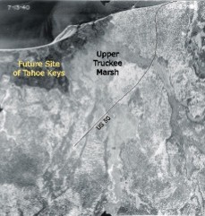 |
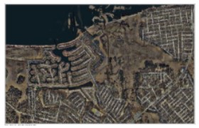
Aerial photograph taken July 1940. The Upper Truckee Marsh is top, center. Tahoe Keys and Marina are not yet in existence at the time of this flight. |
|
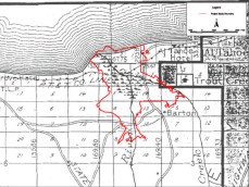 |
Pictured is a 1914 plat map of the Upper Truckee Marsh region. For analysis, The map was georeferenced in the GIS and then compared to the study boundary (shown here in red). The scale of the study boundary is not exact, an example of non technical staff "guessing" at placement. |
|
|
A
n a l y s i s
|
||
|
The
most difficult part in stewarding the Upper Truckee project data is
the acquisition of spatial layers digitized by staff. More often than
not, I find myself revisiting original survey data (e.g. master title
plates, grid sheets) and reconstructing shapefiles. Before my being
brought on board as a GIS Assistant, spatial data files were poorly,
if at all, attributed. This is starting to change as I ask very little
from my co-workers who are not proficient in GIS. Setting minimal standards
for table fields such as "COMMENT" and "SOURCE"
can sometimes provide enough information to at least track down the
person with the answers.
|
||
|
C
o n c l u s i o n s
|
||
|
Much
more work need to be done to convey the message of follow-through with
GIS. Acquiring information is important, but acquiring meaningful well-attributed
information is beneficial. For historic aerial geo-referencing, metadata
creation (e.g. flight number, plate number, date) is absolutely essential
if hard copies are lost.
This project was meant to challenge my own approach to being thrown into a project and the process of recognizing the steps of better GIS data acquisition internally and externally. After final submission, this project will serve as a reference point for presenting keys to smoother data acquisition/creation/management at work. The hope is to communicate clearly, using a common dialogue, to non-GIS staff the benefits of pre project planning and documentation. |
||
|
R
e f e r e n c e s
|
||
|
Fairchild
Aerial Photography Collection at Whitter College. Source: http://www.whittier.edu/fairchild/home.html.
Accessed: 2003.10.05
Popoff,
Leo. 2000. Basin Watch: The Upper Truckee River Basin's Underground
Flow. |
||
|
D at a |||
L i n k s
|
||
|
|
||