A TREE ROUTE IN AUTUMN
A TREE ROUTE IN AUTUMN
Debra Gonzalez
American River College, Geography 26: Data Acquisition in GIS; Spring 2003
Abstract
Deciduous Forests are located in the temperate climate zone, which includes the Eastern half of North America and have four seasons. In the autumn (fall season) the leaves loose their chlorophyll (green color) and show the other colors that were hidden behind the green (yellow, orange, red and brown). The New England state of Vermont is known for providing beautiful displays of autumn color because of the large number of maple and other deciduous trees found in this state. One route and optimum time for viewing the spectacular autumn leaf color is in North Central Vermont from Burlington, Montpelier and St. Johnsbury areas. The foliage season usually begins in mid-September and peaks by the last week of September running into the first week of October. One suggested tree route in autumn is from Vermont Interstate 89 to the town of Waterbury and Stowe Village on Route 100.
Introduction
Deciduous Forests are located in the temperate climate zone, which includes the Eastern half of North America. Deciduous trees have four seasons and the trees change in each season. In the winter they drop most of their leaves. In the autumn (fall season) the leaves loose their chlorophyll (green color) and show the other colors that were hidden behind the green (yellow, orange, red and brown). The leaves change color and fall off in autumn and winter and grow back in the spring to serve as the forests' mechanism for absorbing sunlight and carbon dioxide (for photosynthesis) throughout the spring and summer. This adaptation allows plants to survive cold winters. The sugar maple tree is especially famous for its' beautiful color and is found in the New England area.
The New England states of Connecticut, Rhode Island, Massachusetts, New Hampshire, Vermont and Maine are known for providing beautiful displays of autumn color because of the large number of maple and other deciduous trees found in this region. The purpose of this paper is to explore information available on the web for the best route and optimum time to see the spectacular autumn leaf color in the state of Vermont by searching federal, state, local and other sites for data on the deciduous trees and road data for this region.
In Vermont there are more than fifty species of trees, both coniferous and deciduous. The dominant deciduous forest type in Vermont is called the Hemlock - Northern Hardwoods. The three most common hardwoods are Sugar Maple, Beech, and Yellow Birch. The most common and most important of these in Vermont is the sugar maple, (Acer saccharum). It is especially famous for its' beautiful color and maple syrup production and is the official state tree. It is found all over Vermont, thriving in the rich valley soils and the cool, moist, rocky soils of the uplands. This tree grows 60 to 100 feet high and can typically live 300 years. In autumn as the days get shorter, green maple leaves begin to change color and the production of chlorophyll in the leaves stops. Beech and Aspen leaves turn bright gold or yellow, while Oaks and Maples turn red and purple due to sugar accumulating during photosynthesis.
Due to the weather variables, it is not possible to predict exactly when the leaves will start turning color. The northern regions of Vermont will begin sooner than the southern regions, due to warm afternoons followed by cool evenings. However, an over-abundance of rain and wind or an extreme heat wave and drought, affects the overall timing and vibrancy of Vermont's foliage season.
Background
There are many websites with detailed information about the State of Vermont. There are federal and local government sites, GIS data sites and tourism sites. Vermont Living http://www.vtliving.com/foliage/faqs.shtml is an exceptional site that provides driving directions (routes), the best time of year to see the fall color, extensive lodging information, calendar of events and historical information about the different regions in Vermont. State, county boundary and road data was found from the Vermont Center for Geographic Information. This site provides free GIS shapefiles by themes for download. http://www.vcgi.org/. There are also numerous educational sites both for children and adults that provided information about trees in general and specifically the maple tree.
Methods
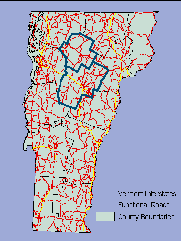
The state of Vermont (as well as the New England area) has several great websites with detailed information about the best scenery and sites to visit. As part of my data exploring, I researched numerous sites from universities and forest service sites to try to obtain information about deciduous trees. This led to my discovery about the importance of the sugar maple to Vermont. In addition, I found the Vermont Center for Geographic Information, a GIS website that has a variety of free downloadable GIS data in shapefiles with extensive metadata. The themes I used were transportation (roads), and county and town boundaries. http://www.vcgi.org/.
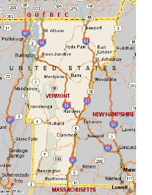
The first road map was created from the Vermont GIS site by downloading the shape files and retrieving them using Arcmap. The data layers presented show the State of Vermont, county boundaries and the many roads of Vermont (including the two Interstates). Due to my limited ArcMap skills, extensive mapping and analysis was not done using GIS. I relied on a collection of data and maps about the area obtained from different websites. The second map of Vermont main highways was obtained from MSN maps.
<
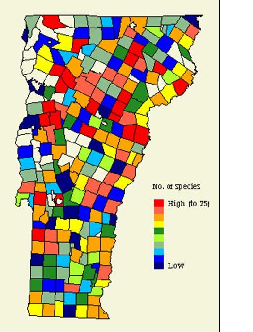
Tree data was the constraint of my project. Data obtained from the Vermont Biodiversity Project provided me with a tree species density map that was viewable as a PDF but not downloadable for use in ArcMap. It did not provide specific tree species detail. However, this map, along with the great tourism site I reviewed was useful to guide me to a decision about the location and route I wanted to travel while in Vermont.
<
Vermont Biodiversity Project
The Nature Conservancy
27 State Street
Montpelier, VT 05602
http://snr.uvm.edu/sal/vbp/vbp6a.html
Accessed: 2003.05.08
This map was obtained from the Vermont Biodiversity Project website. It is a record and summarization of species totals by town. This map was extracted data from a Forest Inventory and Analysis (FIA) to create an atlas of woody trees in Vermont. The FIA data-sampling scheme was designed to provide a regional perspective of species distributions (Hansen et al. 1992), which was used by the Biodiversity Project. Although not complete for some areas of Vermont, the FIA atlas contained over 24,000 records representing 60 of Vermont's tree species. This was adequate information for my purposes and interests which was the northern region high density area.
The final decision on a route was made once I found Vermont Living.com. This was a great site that provided information by region. Once I reviewed the information at this site I knew I was interested in North Central Vermont. In North Central Vermont from Burlington, Montpelier and St. Johnsbury areas, the foliage season usually begins in mid-September and peaks by the last week of September running into the first week of October. (In southern Vermont, change takes place in late September, usually peaking around the second week of October). Vermont in autumn is a destination that requires advance reservations for accommodations. All regions of Vermont for the last week of September and first week of October, often through Columbus Day weekend are filled by August. Most hotel, motel, inn, bed and breakfast, and even most campgrounds, will be sold out during Vermont's foliage season.
Analysis and Conclusion
The purpose of my project was to explore information available on the web for the best route and optimum time to see the spectacular autumn leaf color in the state of Vermont. Based on my research, I found the area and a route that most appeals to me. Route 100 is considered one of the most scenic roads in Vermont. It runs through two small towns, Waterbury and Stowe Village.
Vermont has two Interstates. Interstate 89 runs from White River Junction, Vermont to Canada. One suggested tree route in autumn is from Vermont Interstate 89 to the town of Waterbury, to Route 100. Then from route 100 drive into Stowe Village and the junction of Route 108, the mountain road. From Route 108 drive northwest through Smuggler's Notch to Jeffersonville and the junction of Route 15. Follow Route 15 as it goes slightly north before turning southeast to the Village of Morrisville and the junction with Route 100 to return to Stowe Village. Stowe Village in Lamoille County is one of Vermont's most popular mountain resort towns. Stowe has a population of 3,953 and is home to Vermont's highest peak, Mt. Mansfield, (4,393 feet). It is located on Route 100 North, 10 miles north of the Waterbury Stowe exit of Interstate 89. Stowe Village is 45 minutes from the Burlington Vermont International airport. Waterbury, in Washington County, has a population of 1,652.
My results were successful for my travel plans. I was not successful at finding complete distinct tree population data for Vermont. This was limited because not all of the the tree data I found available from federal and university studies was useable or understandable. I was guided by the tree data from the Biodiversity study and the tourism site, which was sufficient and complete for planning a tree route in autumn.
References
National Digital Map Library
Maintained by geostat@virginia.edu
The Rector and Visitors of the University of Virginia
University of Virginia Charlottesvile, Virginia 22903
Source: http://fisher.lib.virginia.edu/genmaps/natmaps.html
Accessed: 2002.05.08
Vermont Biodiversity Project
The Nature Conservancy
27 State Street
Montpelier, VT 05602
http://snr.uvm.edu/sal/vbp/vbp6a.html
Accessed: 2003.05.08
Provided the map with high tree species sampling.
Complete Tourism information on Vermont. Routes, time of year and calendar of events by regions.
http://www.vtliving.com/foliage/faqs.shtml
University of Virginia free limited use maps of Vermont.
http://comeseeus.net/Stowe/GISVermontUVA.htm
National Digital Map Library
University of Virginia
http://fisher.lib.virginia.edu/genmaps/natmaps.html
MSN Maps and Directions. Map of Vermont with main roads and Interstates.
http://mappoint.msn.com/(ot3dqu55yv2y3n55kbiooz55)/map.aspx?L=USA&C=44.07522%2c-72.66278&A=960.33333&P=|88CE|&TI=Vermont+(state)%2c+United+States
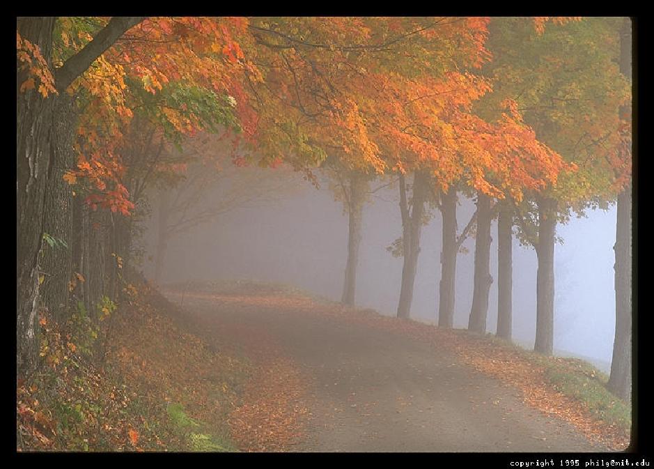
Photo.net.
New England Foliage
A photographer's guide by Philip Greenspun
http://www.photo.net/us/ne/foliage
http://www.photo.net/us/ne/foliage-backroads
Deciduous Trees
Autumn's brilliant orange-red Sugar Maples of New England.
Photo copyright (c): Diane Greer: Diane.Greer@www.gorp.com
http://www.his.com/~mallmary/forestbiomes/deciduous.htm
USDA Forest Service
http://www.fs.fed.us/recreation/map/state_list.shtml#Vermont
State of Vermont Transportation Agency
http://www.aot.state.vt.us/Travelinfo.htm
Vermont.gov
Vermont Maps, referral to the Vermont GISmaps from this site
http://vermont.gov/find-facts/maps.html
Vermont Center for Geographic Information.
This site provides GIS shapefiles by themes for download, free.
http://www.vcgi.org/
major roads:
http://www.vcgi.org/mapcenter/default.cfm?page=mapquery_s.cfm
metadata is available with the data:
http://www.vcgi.org/techres/default.cfm?page=./standards/default_content.cfm
http://www.fws.gov/data/statdata/vtdata.html
U.S. Forest Service
Forest Inventory and Analysis
http://www.fs.fed.us/ne/fia/states/vt/vt_view.html
Vermont Trees
Facts about the tree species found in Vermont.
http://academics.smcvt.edu/vtgeographic/textbook/trees/vermont_trees.htm#Deciduous%20trees
Information about Sugar Maple Tree
http://www.fs.fed.us/database/feis/plants/tree/acesac/all.html
GIS Data
Windham Regional Commission.
Part of the Vermont Geographic Information System
http://www.rpc.windham.vt.us/gis/data/index.htm
Digital Representations of Tree Species Range Maps from "Atlas of United States Trees" by Elbert L. Little, Jr.
ACER Saccharum distribution
http://climchange.cr.usgs.gov/data/atlas/little/
Other interesting sites explored but not used for this project:
USGS Topo Maps of Vermont
http://docs.unh.edu/VT/ltlt32nw.jpg
Resource Restoration in Vermont
http://www.vnrc.org/links.htm
Nasa Images of New England
http://earthobservatory.nasa.gov/Newsroom/NewImages/images.php3?img_id=5205
Appalachian Trail - Hiking
http://www.appalachiantrail.org/hike/plant_anim/trees.html
State Links for maps
http://www.roadmaps.org/links/state-links.html
Tourism
http://www.1-800-vermont.com/
http://www.vermontvacation.com/recreation/biking.asp