| The Difficulties of Datum and Data alignment | |
|
Author Tim Mortensen American River College, Geography 26: Data Acquisition in GIS; Spring 2003 Contact Information (email:timothybecarefulson@hotmail.com) | |
|
Abstract This project is a study of the difficulties involved in getting the readings in a common GPS to align properly with the data layers already being used in a GIS such as Arcmap. I was also interested in finding out more about miss-allignments in data layers. I decided to take a few readings with a GPS and use different datum information to see how the points which were taken, were affected. I also brought in different data layers from different people and tried to find out how they lined up. | |
|
Introduction In trying to find and carry out a project in Data Aquisition I stumbled onto what I thought was a great project. I was trying to find some great mapping detail that I could provide for the benifit of people, when I should have been looking in front of my nose at the actual problems that I have had in data aquisition itself. I found out quite by accident and have learned much since then about the datum used in map layers and the relationship they have with the datum that GPS readings are taken in. I decided to work on understanding more on the breadth and depth of datum differences. I also found out during that process that different data layers made by different people, even if they created the same type of layers, don't line up very well a lot of the time. | |
|
Background I realized the possibilities of this project when I took some readings from my brand new Garmin GPS at my home.I also took some waypoints from a few other places that I could reference by roads and other landmarks. I took those X and Y data and inserted them into Arcmap on some other data that I aquired from the Internet. Well the point laid on top of the other layers fairly well except for the fact that all the points were off by quite a bit. I couldn't figure out what was wrong until I checked the datum on my GPS. I took the waypoints in WGS84 and the map layers were in NAD27. This caused a serious missalignment in where the points should have been and where the map showed that they were. I was also frustrated by the fact that in some of my mapping files, especially roads, If I put two layers from different sources onto the map, they didn't line up exactly. This provided the foundation that I needed to find some interesting information about Arcmap. | 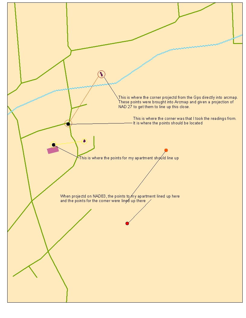
|
|
So what exactly did I do? In this case I did what I've always done and went for a walk. In this case however I took my GPS with me and tried to make sense of my dilema. What datum should I use to collect the waypoints in. Well Idecided to be fair and took the same waypoint 3 times with 3 different datums. I figured that in this way I might show better the scientific method and come to a better conclusion about how the map datum problem might be addressed. | |
|
Results /well, I found quite a bit of interesting information. I did find that even though I changed the datum
when I brought in the waypoints, I didn't really change where the waypoints were plotted on the map I created. I couldn't figure out why untill I
looked at my GPS more closely. I found that changing the datum did't change how the data was saved, but rather it just converts all the information
to the same datum when it is designated. As you can see on the map above, that is why the points designating waypoints are clustered so closely,
the points were brought in all under the same Datum. As I changed the coordinate system in the layer that was made be Arcmap, I found that the points did shift
quite a bit and the points that you see on the map are actually projected in NAD27, while the data frame is projected in NAD83. This has been puzzeling
to me and I haven't figured out quite why that is the case, because when I brought the data in from my GPS, I did so while the GPS was set to NAD83.
| |
|
Analysis I think that the major problem that I encountered were the base layers that I used to map the
points on. The more I looked at the points, I realized that they were spaced much further than they should have been in relation
to the other landmarks on the map. I measured the distance on Arcmap and also used the distance feature on my GPS and found that
they were the same, plus or minus 5 meters or so. As I measured the distance on the map, the map showed that the points distance apart should
have been about half as far. I know that there is some discrepency invloved when dealing with GPS and it can be a little inaccurate, but, on the
map it shows that, if I use the same Datum, that the points are 165 meters from where the map shows they should be. I thought about this for
a while and decided that the map should be wrong. I have found several dicrepencies between maps and gps coordinates, mainly with the maps.
It is rare that I have been more than a few meters off with my GPS and I have used it quite extensivly. | |
|
Conclusions It seems like there is so much data on the web that one could download and it could be used in so many different ways
as base data for GIS research. I have found that this is definately not the case. While much of the data is very helpful and can be used for
a lot of different things, I have found that one must be careful about the data that is used. In sensitive research, spatial data may need to be very accurate
and the need for accuracy in the aquisition of the data is very important. I have learned that the metadata is imperative in knowing exactly what
the data is and its accuracy and reliability.
Just recently I have had several experiences with problematic maps. Mostly involving paper maps and base layers. It seems that public domain
data is not kept current enough for people who use the data on a regular basis. Unfortunately that is all we have. It seems like there would be a simple
way to be able to modify and update the data as neccessary in order to give people access to relativly accurate and unbiased data sets.
| |
|
References esri.com Data and Arcmap Some data sets were provided by Tom Trexler, instructor, EWC | |