Title Exploring the Sacramento Northern Railroad Bike Trail, North of I-80 | |
Author Anna Marie C. Clifford American River College, Geography 350: Data Acquisition in GIS; Fall 2003 1128 Bell Ave, Sacramento, CA 95838 916-923-9980 Anna.Clifford@boe.ca.gov | |
Abstract Mapping my neighborhood bike trail was both fun and challenging. I learned to used a GPS and convert the acquired data points into shape files. I also learned to acquire data online and in the field. There were more challenges to mapping and data acquisition than I expected. The challenges stemmed from finding appropriate data to the inablility to convert publicly available data into usable data. But after many hours of research, organization, and a lot of trial and error, I finally completed my project. | |
Introduction My family and I use the neighborhood bike trail for recreation. I wanted to chart my route and note the locations of various places along the way so anyone who is unfamiliar with this bike trial will know what to expect. | |
Background To familiarize myself with mapping a neighborhood bike trail, I focused intently on the techniques used in the mapping of the Grand Canyon, by the people of the Grand Canyon Monitoring and Research Center, and combined those techniques with the skills I learned both in class and at work. Mapping the Grand Canyon relied on photogrammetry and in-field data gathering with GPS. (Liszewski, 2003). At work I learned to use AutoCAD to size and orient images. And at school I learned how to work with graphics in ArcMap as well as gather waypoints and upload them into the computer. With this knowledge I was able to map my neighborhood bike trail. | |
| This article helped me formulate a plan for mapping my
neighborhood bike trail:
The Grand Canyon's Landmark Map Dataset, by Mike Liszewski (last accessed: 12/05/03).
|
|
Methods The first part of gathering data began by traveling the trail on bike with my family, GPS unit in hand. (I used a Garmin 12x GPS.) After my fiance fixed my flat tire, I started from my home and stopped to mark every turn, telephone, bridge, and street crossing. Because I forgot to bring a pen and notepad to jot down additional data, I used various symbols to identify one point from another. For example, if I crossed a street, I would label that point with a car symbol. If I marked a point for recording curves along the trail, I let the GPS unit add the defaul symbol. After all points were gathered, I uploaded them into a computer as a text file and also as points and lines in ArcMap. Next, I searched the Internet for aerial photos of the area. After the photos were found and acceptable, I saved them as bitmap images. Then I imported the point and line shape files into AutoCAD Map 5. In the AutoCAD program I was able to insert, size and rotate the aerial images I found. With the aerial photos as a backdrop, I was able to digitize some objects that were near the bike trail. I saved the digitized line work and exported them as a shape file so they could be viewed in ArcMap. To add more coverage, I inserted a digital raster graphic (DRG) from CaSIL ( California Spatial Information Library). The image had street lines, hydrology, airports, and other supporting information for the area. The DRG, GPS points and lines, and digitized line work were acceptable, so my data gathering was complete. The last step was to finalize the presentation of my data. In ArcMap, I removed unnecessary points and added labels to existing points. Then I named a few major roads that were not visible on the DRG. | |
Results The Sacramento Northern Railroad Bike Trail
North of I-80: The Clifford-Price Family Route | |

|
|
|
Here is a complete list of raw data that was collectted from the GPS unit. These attribiutes were converted into point and line shape files.
Datum,WGS84,WGS84,0,0,0,0,0
| |
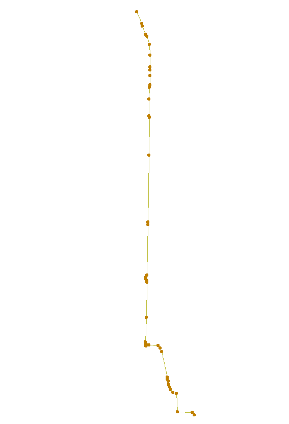
| The data appears as various points connected
by lines when viewed in ArcMap.
|
|
| This example shows the work that was done in
AutoCAD. Shape files from lines and points acquired by the GPS unit were imported and
bitmap images were sized and oriented to fit. The aerial images were found at MapQuest.
|

|
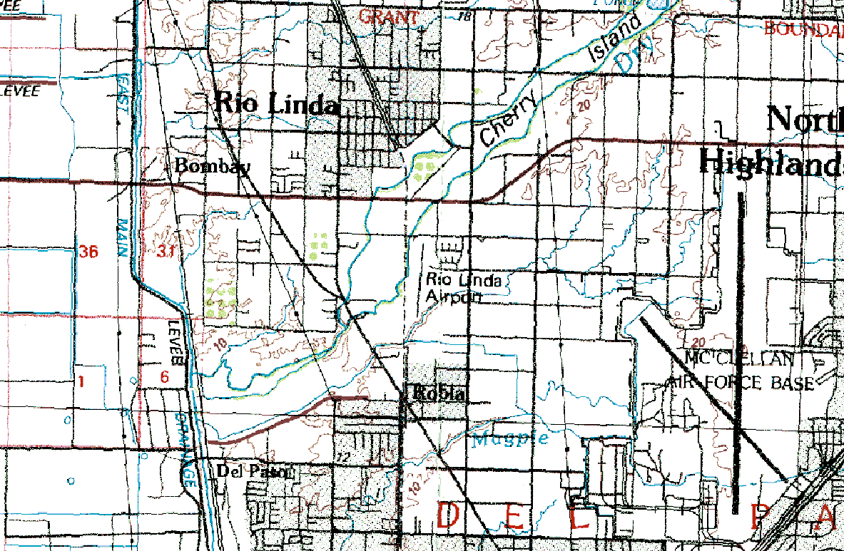
| The Digital Raster Graphic used as a
backdrop for my waypoints is of Sacramento, California (f38121e1),
30x60 Minute (F) Series, Albers Nad27 Trimmed. This image was used because
it uses the same projections as my waypoints.
|
|
Analysis Gathering data was not as easy as it seemed. There were multitudes of information available, but most were not in formats that were usable for overlay with my waypoints. The first problem I encountered was that my unique symbols stored in the GPS unit did not display as unique symbols in ArcMap. So, I had to jot down each waypoint on a sheet of paper and identify them with the symbols stored on the GPS unit. The second problem I encountered was trying to get aerial photography into ArcMap. Most of the images I found were not acceptable for viewing at a large scale. I finally discovered aerial photos on the MapQuest web site that could be saved as bitmap images. Unfortunately the images covered a small area, so I had to save many images. Plus, the images were unprojected which posed another problem for me. To correct this problem and gather the data needed, I looked no further than AutoCAD Map. I was able to size and rotate each image to fit my waypoints. After the images were placed, I digitized over roadways, creeks, and other features that I wanted to emphasize. Then I planned to transfer the entire drawing along with the images into ArcMap. But this was not possible. The images could not be transferred because I could not save those images at the same scale, coordinates and rotation with AutoCAD. I could only save the references in AutoCAD, which would locate my images on the computer, then project them according to those saved references. It would not allow me to alter the original bitmaps. The bitmap images were useless to me from this point on because I could not get them into ArcMap. To work around this problem, I chose to look for better backgr ound information that was already projected; however, because I did not want to lose the items I digit ized, I turned the line work into a shape file that could also be put into ArcMap quickly and easily. | |
Conclusion Because of limited time and funding, the data accumulated only serves as a very basic visualization tool of the Sacramento Northern Railroad Bike Trail, North of I-80. With adequate funding, an exceptional aerial photo of the entire area could be attained. If there were more time and the product was of a collaborated effort, a fun, casual map could have been produced with photo call-outs of the beautiful oaktree lined trails and waterways. Other items to be researched are important facilities near, but not directly along, the bike trail route; such as, nearby fire departments, bike shops, restaurant pads, etc. | |
References Liszewski, Mike. "The Grand Canyon's Landmark Map Dataset."
Geospatial Solutions, March 2003, p. 26-30. | |