| Title Shopper’s Guide by a GIS | |
|
Author Kim Emerick American River College, Fall 2003 Geography 350: Data Acquisition in GIS 9233 Caspiane Way Sacramento, CA 95826 e-mail kimikot49@yahoo.com | |
|
Introduction A GIS application can be used to aid shoppers who are having a difficulty to find items and sections in unfamiliar, giant supermarket and retail stores. Using ArcObject application, a shopper can see the store layout and a form on a computer screen at the same time. The layout clearly shows the location where the shopper stands with “You are here”. On the form there are option buttons labeled with different languages; English, Spanish and Japanese, a list of items or sections in the store and a command button “Show Location”. When the shopper chooses any item in the list or location and click the “Show location”, the location of the chosen item or section will be displayed and highlighted with red on the store layout. The shopper can see the location of the chosen item/section in relation to the store layout and the location where s/he is standing. A shopper can find a section/item on the store layout in less than a few second, by choosing a language and section/item and clicking the “Show Location”. | |
|
Background It’s often difficult to find an item or section in a unfamiliar large supermarket or large retailers like one in Figure 1 and 2. Customarily a shopper finds a store employee and asks where the item or section is located. However, if the market is huge, often the shopper may have to ask a few more store employees to find the item or location. However, if the shopper can't find any available employee, then the shopper has to wait or walk every isle to find the item or the section. A store layout will help, but when local supermarkets (Safeway and Albertson stores in Citrus Heights, CA) were visited, none of the stores did provide store layouts. There are occasions; even store employee can't help some shoppers, i.e., the shopper can't speak nor hear or does not speak the same language. A solution to the aforementioned problems can be solved with a GIS program. A GIS program can be used to help the shopper find item or location in the huge supermarket stores or large retailers easily and expeditiously. 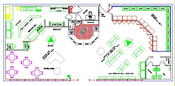 | |
|
Figure 1: Store Layout Design | |
 | |
|
Figure 2: A Section of the Store | |
|
Methods The Shopper’s Guide was programmed with ArcObject with VB Application. A Shopper Selection form (Figure 3) and the store layout(Figure 4) are shown on the computer screen. 1. A Geodatabse was created with ArcGIS version 8.3. This involves digitizing the store layout and adding fields (English, Spanish and Japanese) to the feature class table and populating the attributes with items or sections in the store with those languages: English, Spanish and Japanese. 2. A map project was created and the store layout was added to the project. 3. With the VB application with the ArcGIS, a form is created for input from a shopper. The form consists of radio buttons with different languages (English, Spanish and Japanese), a section list combo box, an item list combo box and a “Show Location” command button, all of which are given special instructions programmed with the VB application. When a radio button with specific language is selected, all label captions, a list of section and items in the combo boxes and command button captions will be shown with the chosen language. On the store layout, major sections (i.e., Meat, fresh vegetable, bakery, pharmacy, customer service, flowers, international food section, dairy products) are clearly labeled with the language chosen by the shopper. Some sections may encompass more than one areas. The shopper can choose an item or section s/he wants to find and click the "Show Location" on the form. “Bakery” is the default in the section combo box. The customer can choose only one from either section or item combo boxes. When the "Show Location" button is clicked, the item or section location will be high lighted with red color on the store layout. The "You are here" is distinguished from other sections so that the shopper know exactly where s/he is at the store in relation to the store layout. | |
|
Results A shopper can choose any language in
the application, choose section or item, then click the “Shoe Location”
button. Within less than a second s/he can see where the item/section is
located and where s/he is in the store layout in the store layout.
| |
|
Figures and Maps 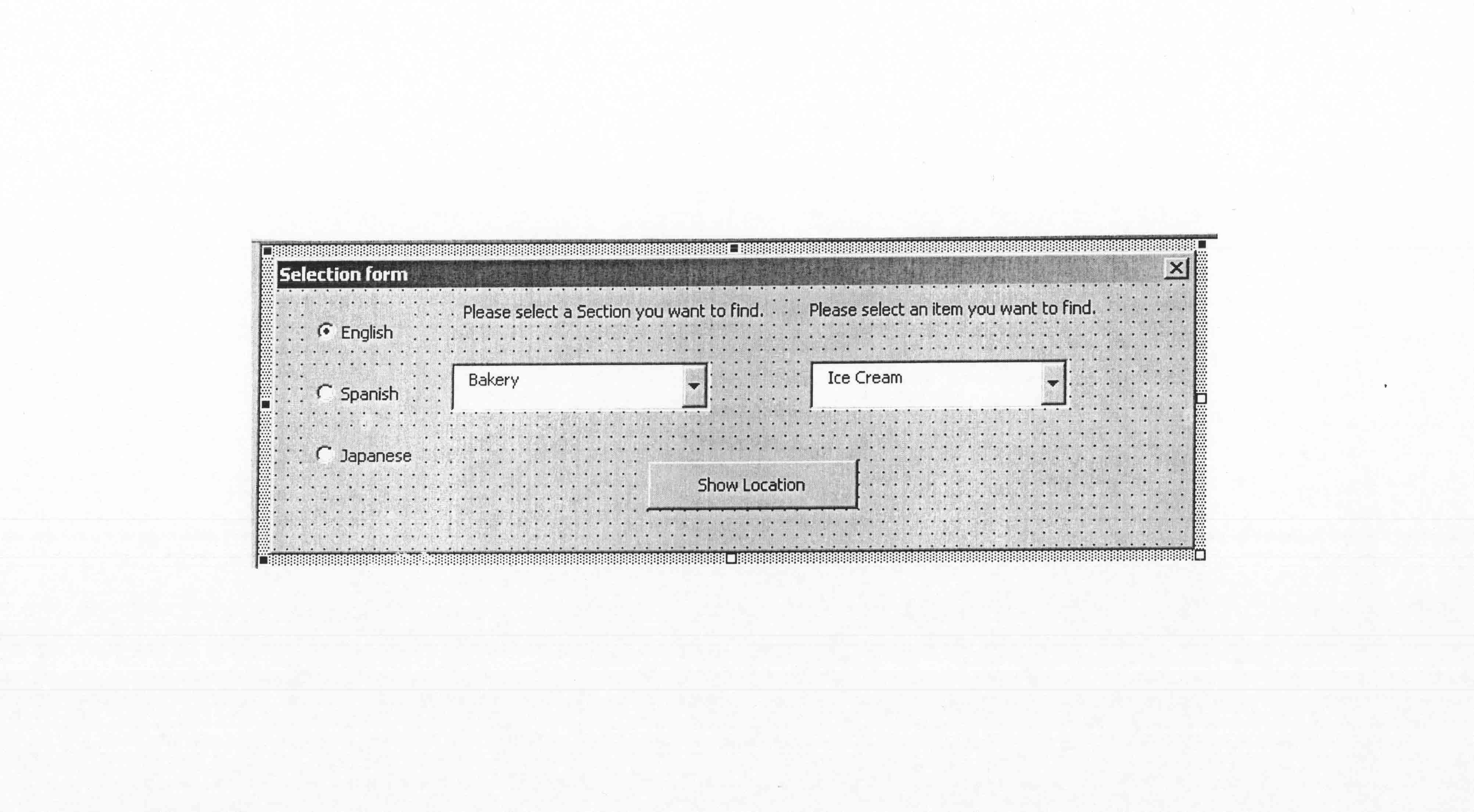 | |
|
Figure 3: A Shopper Selection form | |
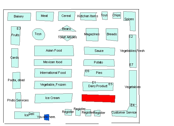 |
Figure 4: Store Layout and selected Section in red |
|
Conclusions This program is easy to use and a shopper can find a section or item easily and expeditiously. A shopper must choose a language listed in the program, select a section or item and click on “Show Location”. This program can be used with any supermarket stores as long as the geodatabases are created in a similar fashion. This application can be used any large retailers or shopping malls, as long as the geodatabase was created with in similar format; i.e., the field' names are exactly the same type (i.e., text) ; the store layout is digitized with the exactly the same feature (polygon feature in this case). This Shopper’s Guide principle can be applied to city guides or points of interest finders at National parks. For example, this program can be used to find churches, restaurants, vista points, golf courses on the computer screen with a few clicks. | |
|
References Getting to know ArcGIS,
Tim Ormsby, et all, ESRI, 380 New York Street, Redlands, Ca 92373-8100
Getting to know ArcObject, Robert Burke, ESRI, 380 New York Street, Redlands, Ca 92373-8100 Modeling out World, The ESRI Guide to Geodatabase Design, Michael Zeiler, 380 New York Street, Redlands, Ca 92373-8100 Using ArcMap, GIS by ESRI, Michael Minami,380 New York Street, Redlands, Ca 92373-8100 http://aislebyaisle.com/marsh-grocery-store.htm http://www.supermarketservices.com/store%20design.htm | |