Title
Finding a place to live at preferred locations
-- Application of GPS-GIS to solve a day-to-day issue
|
|
Author
Lawrence Law
American River College,
Geography 350: Data Acquisition in GIS; Fall 2003
E-mail: lawrencelaw772000@yahoo.com
|
|
Abstract
The example given here is to show how GPS and GIS can be applied to daily usage. The hypothetical scenario here is that a retiree who is looking for a place to live in Sacramento. This person prefers to find a residence within 1500-meter walking distance to a local church and a city park, which are essential parts of this person's life style. If the method presented here works for this scenario, other comparable scenarios could also be resolved by the GPS-GIS approach.
|
|
Introduction
This case intends to show how GPS and GIS can be used for day-to-day living. The scenario is that a retiree decides to move to Sacramento to retire. He prefers to live in a place whereby it is within walking distance, within 1500 meters, to a park and a church. Nearness to his residence of these two sites are important to his lifestyle. The church denomination chosen here happens to be Roman Catholic. However, it could be a synagogue, a mosque, a country club, a casino, a community center, or church of any denominations and faith.
The approach is to use a GPS receiver to waypoint the locations of selected churches and parks. The waypoints are then input to a GIS system. The waypoints and the Sacramento city map are projected together. The distances surrounding these parks and churches are derived. Those churches and parks that are within walking distances to each other are identified. Areas covered by these walking distances are selected as potential areas for residence.
|
|
Background
The author is new to GIS and has no connection to any establishments which may have a need for GPS or GIS application. Therefore, the author focused on the day-to-day need of any person and saw whether GPS-GIS could help. The project is an effort to this direction.
|
|
Methods
The process of this project was done in the following phases:
- Data Acquisition by Waypointing -- Through internet querying, a list of Catholic church names and addresses in Sacramento were obtained. By using mapquest internet query, their locations were found in the e-maps. By looking at a map, the city parks were identified. A field trip was arranged to go to these churches and sites. Usually, waypoints were made in front of the churches and at the side of the parks by using a Garmin GPS receiver.
Waypoints made for church sites:
| wpid | Lat | Lon | Organization | Address
|
|---|
| 01 | 38.5702410 | -121.5015630 | Our Lady of Guadalupe Church | 711 T Street, Sacramento, CA 95814
| | 04 | 38.5790600 | -121.4924970 | Cathedral of Blessed Sacrament | 11th & K Streets, Sacramento, CA 95814
| | 05 | 38.5698330 | -121.4950290 | St. Elizabeth Catholic Church | 1817 12th Street, Sacramento, CA 95814
| | 06 | 38.5736850 | -121.4731960 | St. Francis of Assisi | 2529 K Street, Sacramento, CA 95816
| | 07 | 38.5695270 | -121.4547480 | Sacred Heart Church | 1040 39th Street, Sacramento, CA 95816
| | 08 | 38.5547590 | -121.4711740 | Immaculate Conception Church | 3263 1st Av, Sacramento, CA 95817
| | 13 | 38.5184370 | -121.4696560 | St. Rose Catholic Church | 5961 Franklin Blvd, Sacramento, CA 95824
| | 14 | 38.5283500 | -121.4870420 | St. Robert's Church | 2243 Irvin Way, Sacramento, CA 95822
| | 15 | 38.5191610 | -121.4327490 | St. Peter's Catholic Church | 6210 McMahon Dr, Sacramento, CA 95824
| | 16 | 38.5399160 | -121.4278510 | St. Philip the Apostle Church | 3866 65th Street, Sacramento, CA95820
| | 18 | 38.5503660 | -121.4983290 | Holy Spirit Church | 3159 Land Park Dr, Sacramento, CA95818
| | 20 | 38.5597260 | -121.4349430 | St. Mary's Catholic Church | 1333 58th Street, Sacramento, CA 95814
| | 21 | 38.6102750 | -121.4106200 | St. Philomene Church | Bell & El Camino Av, Sacramento, CA 95825
| | 22 | 38.6082910 | -121.4572640 | St. Joseph's Catholic Church | 1717 El Monte Av, Sacramento, CA 95815
|
Waypoints made for park sites:
| wpid | Lat | Lon | Park | Location
|
|---|
| 02 | 38.5692700 | -121.5028240 | Southside Park | T & 8th Streets
| | 03 | 38.5815920 | -121.4940800 | Downtown Plaza | J & 5th Streets
| | 09 | 38.5638840 | -121.4426350 | East Portal Park | M & 51st Streets
| | 10 | 38.5742800 | -121.4614860 | McKinley Park | H & 33rd Streets
| | 11 | 38.5582670 | -121.4668820 | McClatchy Park | V & 34th Streets
| | 12 | 38.5477050 | -121.4794990 | Curtis Park | Sutterville Road & E Curtis Dr
| | 17 | 38.5413370 | -121.4935270 | Land Park | Land Park Dr & 13th Av
| | 19 | 38.5448080 | -121.4363370 | Tahoe Park | 8th Av & 61st Street
|
- Downloading waypoints from GPS to GIS -- By using the VB Garmin software, waypoints from the Garmin GPS receiver were downloaded as shape files to a personal computer installed with ArcMap GIS software. The first set of waypoints input was the church locations and the second set the parks.
- GIS Map Projection -- ArcCatalog was invoked. Two Sacramento e-maps were selected, namely a street map and a city map with identical scale and projection. The maps and all the waypoints were projected with the coordinate system -- NAD 1927 StatePlane California II FIPS 0402.prj.
Spatial Reference from ArcCatalog:
| Datum | USA_Contiguous_Albers_Equal_Area_Conic
| | False_Easting | 0.000000
| | False_Northing | -4000000.000000
| | Central_Meridian | -120.000000
| | Standard_Parallel_1 | 34.000000
| | Standard_Parallel_2 | 40.500000
| | Latitude_Of_Origin | 0.000000
| | GCS_North_American_1927
|
| Geographic Coordinate System
|
|---|
| Alias | none
| | Abbreviation | none
| | Remarks | none
| | Angular Unit | Degree (0.017453292519943295)
| | Prime Meridian | Greenwich (0.000000000000000000)
| | Datum | D_North_American_1927
| | Spheroid | Clarke_1866
| | Semimajor Axis | 6378206.400000000400000000
| | Semiminor Axis | 6356583.799998980900000000
| | Inverse Flattening | 294.978698200000000000
|
- GIS Data Input -- The projected maps and waypoints were input into ArcMap as the following layers: the church waypoints, the park waypoints, the street map, and the city map. Additionally, the church names and addresses, park names and locations were geocoded into the attribute tables of the waypoint layers by editing the waypoints' corresponding .dbf files in MS Excel.
- GIS Spatial Analysis -- Distances of 1500 meters were derived from the church and park sites by using ArcMap Spatial Analyst. Overlap areas among the walking distances to the churches and parks were demarcated as the qualified areas in which a residence can be selected for the retiree. Please read the Results section for detail understanding.
|
|
Results
The pictorial explanation is as follow:
A. The process of spatial analysis in GIS -- The first of the following two sections of maps shows the overall view of the street map of Sacramento and how the analysis is developed. The second section shows some details of the finding.
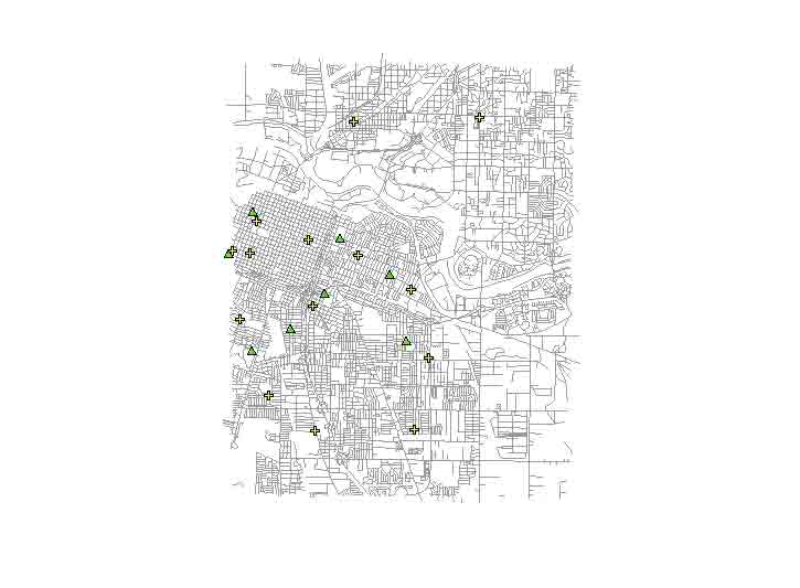
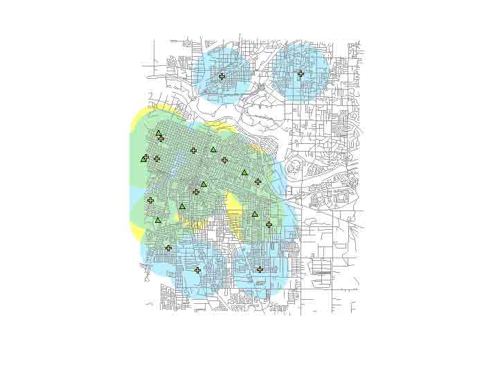
- The map shows the street map of Sacramento. This street map and its counterpart the city map were presented in class few times in this semester. The yellow crosses denote the church sites and the green triangles the city parks. Not all city parks are indicated due to resource constraints but enough for the case.
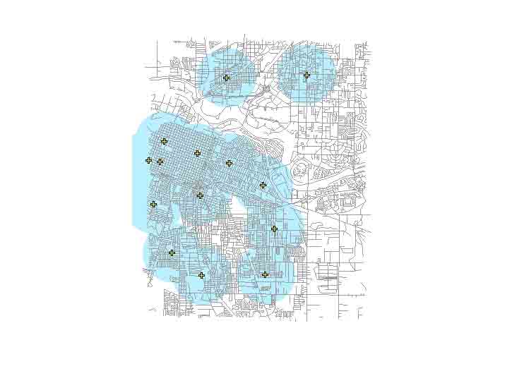
- The following map shows only the church sites. The blue circles surrounding the yellow markers show the 1500-meter walking distance radii around the sites. This shows the sites are most locaed at central and southeast part of the map. The retiree has large potential areas to choose a residence.
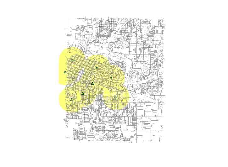
- The following map shows only the city park sites. The yellow circles surrounding the green markers show the 1500-meter walking distance radii around the markers. This shows the sites are mostly located at central and southeast part of the map. Again, the retiree has large potential areas to choose a residence.
- The following map shows both the church and park sites with their surrounding distance circles. The areas where the blue and yellow circles overlap are in translucent green. Any where within the green areas are potential areas for the retiree to live whereby he can both walk to a church and a park. The blue areas alone can let him walk to a church only while the yellow areas only a park but not both. The city areas outside the blue, the yellow, and the green are beyond the walking distances of both a church and a park. The map shows the churches and the parks that are mostly located around the center and eastern parts of the map, which are areas developed earlier. While few churches locate outside the older part of the city fewer are the parks.
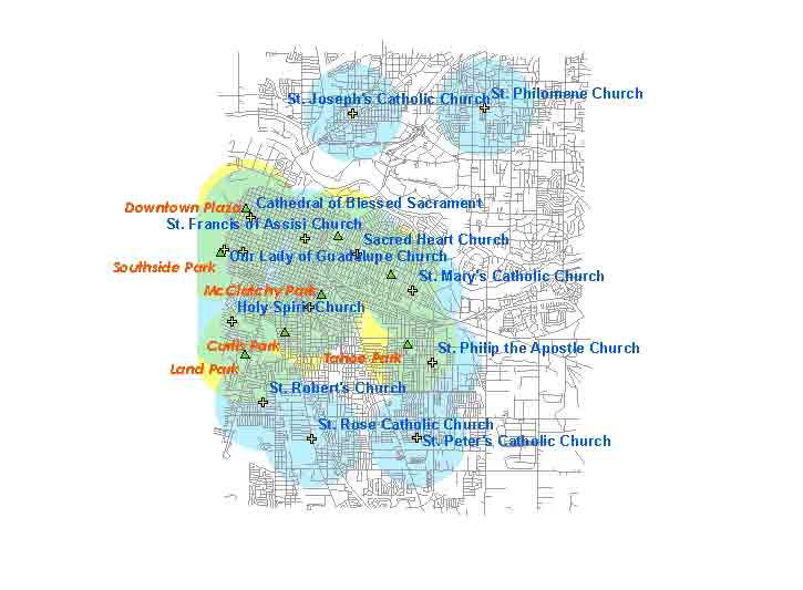
- The following map shows the names of the churches and city parks. The names and their addresses are geocoded in their attribute tables in ArcMap.
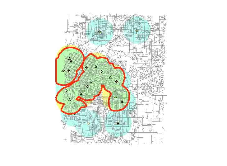
- The following map shows the redlining of the circumference of the green areas, which are areas overlap with the blue and the yellow. The red-lined areas in green are the preferred areas for the retiree to choose a residence. These areas are all within the 1500-meter walking distance to a church or a park.
 B. The detail look of spatial findings
-- While the previous maps show the overview of the city, the following maps give a detail look at sections of city of Sacramento.
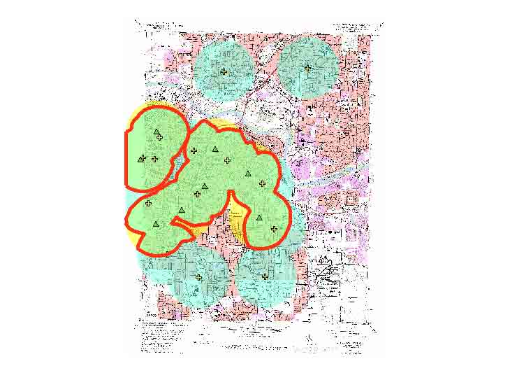
- The following map shows the redlining of the circumference of the green areas in a city map. While the street maps previously shown are neat and easier to read the city map shown here contains a lot more city information.
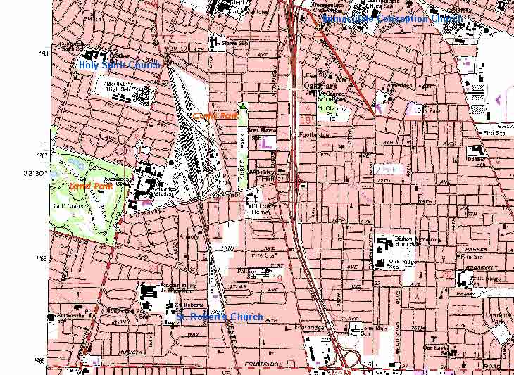
- The following map shows the eastern side of the city map, which shows street names, major organizations in the locales, and freeway exits. The city map is useful in further assessment of home searching. Three yellow cross markers (churches) are found (northwest, north, southwest), and two green triangles (parks) identified (west, central).
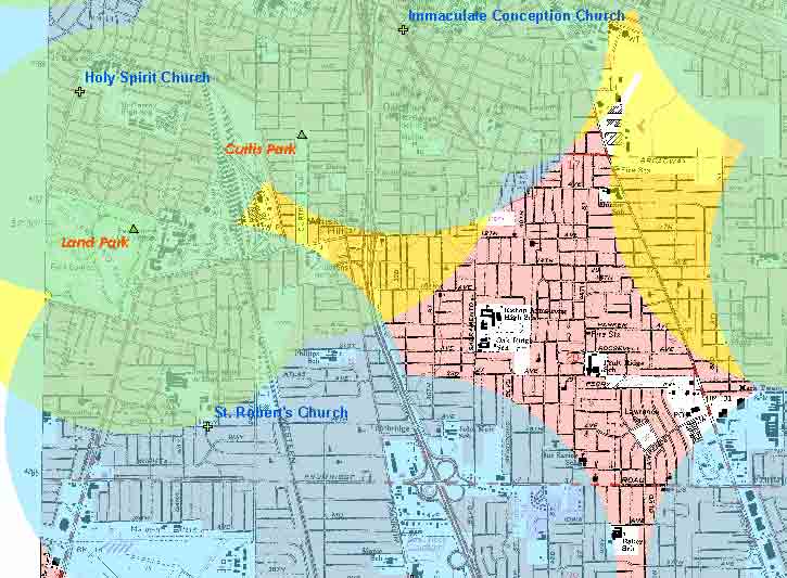
- The following map shows the blue and yellow walking distance circles surrounding the churches and the parks. The green areas are the overlap areas, the preferred areas to choose a residence.
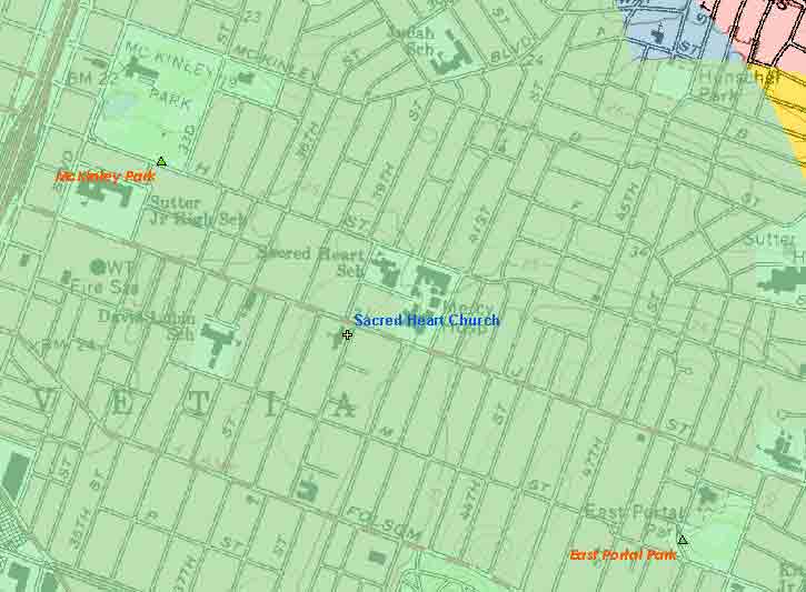
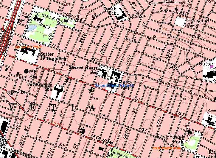
- The second example shows an even more detail view, which is near the center of the overview street map. Here, a yellow marker is found (center) and two green triangles identified (northwest, southeast). The map also shows churches of other denomination, a nearby hospital, and schools.
- The following map shows most of the coverage is suitable to choose a residence because it is mostly a green area. The not suitable areas, namely the blue, the yellow, and the uncovered are all in the northeastern corner of the map. Other green areas can be perused at this detail level by using the city map, not the street map.
|
|
Analysis
The difficulty of the project turns out to be the map projection. NAD83, a popular datum, was used for the first round of waypointing only to find out that the datum of the e-maps were undefined but should be in NAD27. As expected, the waypoints were projected incorrectly on the maps. Not knowing that raw waypoints (latitude and longitude) can still be downloaded from GPS to GIS before a datum is chosen at GIS, a second round of waypointing was made in NAD27. However, after the second round of downloading to the GIS, the waypoints were off uniformly from the exact locations about eight street blocks south in the map.
The issue was brought up to the attention of the instructor Mr. Paul Veisze in class. Mr. Veisze downloaded the raw waypoints regardless of the datum. The city e-map was defined with NAD27 with some customization for false-easting, false_northing, central_meridian, Standard_parallel_1 on the fly. The city map was input to ArcMap first followed by the waypoints, which followed the existing datum of the GIS data frame, i.e. NAD27. The result was the exact matching of the waypoint locations on the map. The problem was resolved.
The accuracy of the waypoints on the map is astonishing. First, the e-maps, street and city maps of Sacramento, provided by Mr. Veisze are highly accurate. Second, the additional specification on the NAD27 datum was accurate also. Third, the waypoints were accurate also for they appeared on the maps at the exact locations where they were captured at the physical sites. This shows the significance of datum in map projection.
A minor difficulty was encountered but never resolved, i.e. the mystery waypoint for the McClatchy Park. When projected the waypoint was about 10 blocks north of the actual location in the maps. It is not known whether the waypoint was captured accurately but at the wrong location or it was captured inaccurately at the right location. Given the fact that all other waypoints were accurate the former is more likely.
On hindsight, since a city park occupies larger area, instead of only taking one waypoint it makes sense to make waypoints at major corners of a park thereby a polygon is used to represent a park at ArcMap to enhance the accuracy of area coverage.
|
|
Conclusions
Surely, looking for a place to live or to do business is more than spatial analysis. The latter performs an important function and saves unnecessary efforts spent on undesirable areas. After the qualified areas were identified more field trips and fact findings are necessary to pick the right residence. However, this would be out of scope of the GPS-GIS project.
Looking for a suitable location to live or to do business within a given area is a common issue for anybody. While the hypothetical scenario described may seem to be narrow in scope for GPS-GIS application, the method presented can apply to a number of corollaries, such as...
- A working mother is looking for a residence whereby it is within a short distance from a daycare center and a supermarket so that she can take her kids to and from the center before and after work and shopping.
- A person who prefers not to drive is looking for a residence whereby it is within walking distance to a bus stop and a supermarket.
- A factory owner is looking for a warehouse site, which is preferable to be within two miles from a major freeway exit, one mile from a gas station, and 20 miles from an airport.
- A business owners prefers to lease an office site within a quarter mile from a shopping center, three miles from a major freeway exit, and within ten miles from residential areas.
- Other similar types of application...
Lastly, the author would like to thank the following individuals who help this project a success...
- Mr. Rick Foster, a classmate, who suggested to make waypoints for organizations like day care centers in a city for day-to-day function when the author had no idea what to pursue for the project.
- Mr. Paul Veisze, the instructor, who generously provided the Sacramento e-maps and demonstrated in two class occasions how to customize a coordinate system to make accurate projections for the waypoints and maps.
- Mr. Ronnie I. Caluza, a classmate, who showed the author how to export an ArcMap image to a JPEG file to be presented in html and let the author use his project's html file as the template for the author's html file, which is a project requirement.
|
|
References
Sacramento city e-maps (street & city maps), -- Digitized by Mr. Paul Veisze/ARC.
Garmin global positioning system (GPS) receiver, -- Used in capturing waypoints at selected parks and churches.
ArcGIS software, -- ArcCatalog and ArcMAP equipped with Spatial Analyst to do the GIS analysis.
|