| Title Advertising The Van Vleck Recreational Area | |
|
Author Colleen Murphy American River College, Spring 2003 Geography 350: Data Acquisition in GIS 9233 Caspiane Way Sacramento, CA 95826 e-mail colleen0103@yahoo.com | |
|
Introduction Advertising the Van Vleck Recreational Area is a hypothetical project. The Van Vlecks did not give permission or are they intrested in advertising their area. The problem to be solved was that the area and trails had to be mapped out. Outside data had to be collected. | |
|
Background The Van Vleck Recreational Area is on a privite membership bases. My family have been members for several years now and we enjoy the area all year round. This project is hypothetical and the Van Velecks have no intrest in advertising or increasing membership as it is by invite only. | |
| My background is in business. I have
owned several business and have done the advertising for all of the businesses.
I am going to use GIS in the business industry. All of the projects and papers
I have completed in the past have been business orientated.
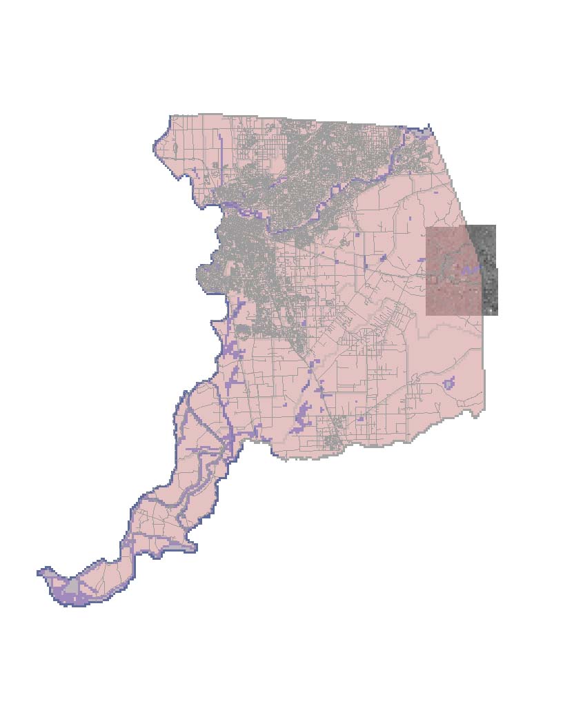
This map shows the area in which the Van Vleck Recreational Area is located. |
|
|
Methods American River College and Geography 350 provided me with the necessary GPS unit to map out the area. The GPS unit was very valuable to this project. I set out on a sunny day GPS unit and log book in hand and begun the process of mapping the road in. This was the test run to see how the unit and data would download onto the schools computers. It took two nice sunny days to map out the area.I keep a log book with all the information on the way points and any other information I would need for creating the data base for this project. The data collected from outside sources was a long trial and error process. I first searched for digital elevation models for the area. The area has rolling hills and DEM's would have made the area stand out in the mapping process. The DEM's were missing part of the data I needded for the area and I could not use them. Next I searched for Aerial Photography of the area and agian part of the area was missing. I found the digital raster graphics while I was looking for digital ortho quads. I chose DRG's over DOQQ's because the DRG's had a better apperance in the final map. Finally I wanted the waterways, roads and the outline for Sacramento County. I had collected this data last semester and saved it so I could use it agian. |
|
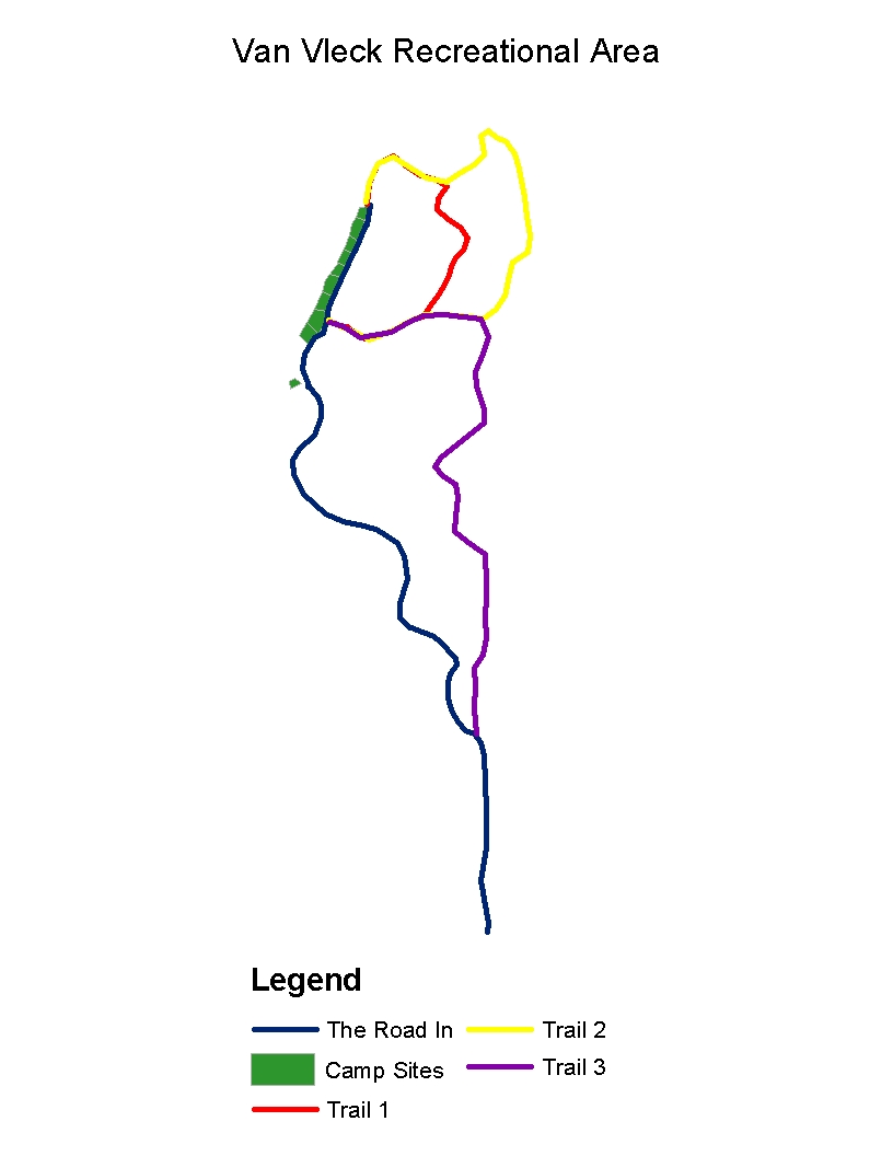
| This view is of the area without any outside data. This data will be used in creating the brouchure to give the potental member a map of the recreational area. |
 |
|
Results ARC Map is what I used to produce the images.The
data that did not match up I found that it would be too time consuming to correct. I
swicthed projection to match and tried varies other things, but in the end I found that
editing the material would be the only solution. I felt I had enough information collected
to make a brochure.A Germin GPS hand held unit is what I collected the data for the campsites, trails and road in. I tried to use several different features on the GPS unit. The Trails feature I used for the road in and the trails. The feature would work well for navagation but not for mapping out an area. The problem that I ran into was that the list of waypoints is not long enough.If the roads or trails are to long of have numerous curves you need more waypoints than are allowed. | |
|
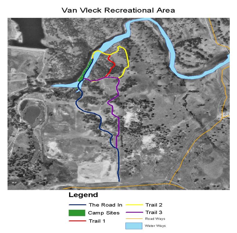
Figures and Maps As you can see all data is not
what is seems to be. This data of waterways and roads shows how two different
sources can be very frustrating and time consuming to match up. | |
 |
 |
|
Conclusions I have gathered enough information for the
brochure. I will create a brochure for my marketing class. I found that I needed to
clearly map out the extent of the project. If the project is clearly defined it would
save time and money. Searching for data is very time consuming. The more you search the
more data you find. It can become quite overwhelming at times. I found that if I kept a
log of the websites, what I gathered and were I download it to it was not so overwhelming.
I found it very helpful that I saved the outside data from last year even though it did not
work. Having a good database cuts down on the time spent searching for data. Finially I learned
that you need to be creative in your approach to projects like this. If you keep an open mind and
let the possiblities flow It will be alot of fun and a great experence. | |
|
References California Spatial Information Libary(CASIL) Sacramento Area Council of Goverments (SACOG) American River College Garmin GPS Unit Geography 350 for the great ideas Leg work of the author Lu Hoge & Terrie Bressette for the membership and the key The Van Vleck Recreational Area | |