WHERE IN THE WORLD......should I go diving?
American River College, Geography 350: Data Acquisition in GIS; Fall 2003

From a list of top 100 dive sites I chose six locations that I wanted to explore further. For each of these six cities I obtained latitude/longitude information, air temperature, water temperature, minimum and maximum underwater visibility, air/hotel cost and most importantly, diving attractions. In order to use the attractions in a query I assigned each site an attraction rating, ranging from 1-5. I then performed a query in ArcView of my most important criteria - air temperature, water temperature and dive attraction score. Three cities met these criteria - Cozumel, Belize and Little Cayman. I did a little more research to arrive at my number one site.
This project was a very simple GIS project, but it was not without problems. One problem was that not all of my six cities were an existing city in the ESRI map that I imported. I overcame this by inserting a theme event in ArcView based on my cities' latitude and longitude data.
This project was very interesting to me and I learned a lot from it, about diving and about GIS. But, I might have learned more had I chosen a project that allowed importing of more database files.
 temperature
is 79 degrees and the water temperature is 77. Visibility is between
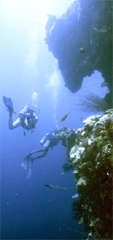
120-160 feet. Cozumel diving attractions include the clarity of the water
and abundant variety of marine life. Coral reefs and rock formations that
form walls, tunnels and caves add adventure. The cost of air fare and hotel is $2550
temperature
is 79 degrees and the water temperature is 77. Visibility is between
120-160 feet. Cozumel diving attractions include the clarity of the water
and abundant variety of marine life. Coral reefs and rock formations that
form walls, tunnels and caves add adventure. The cost of air fare and hotel is $2550
Puerto Vallarta is located on the western coast of Mexico in the
Pacific Ocean. It is actually in the Bay of Banderas which provides calmer
waters. The average temperature is 72 degrees and the water temperature is
75 degrees. Visibility is 20-30'. Diving attractions include El Morro
Island which lies beyond
the Bay where larger sea life can often be found, including whales,
sharks, mantas, dolphins and sailfish. The terrain consists of a series of
pinnacles that rise from the ocean floor creating caves and tunnels. There
are several other islands that are good diving locations. These include
the Marietas Islands and Los Arcos. The cost of air fare and hotel is
$1424.
the Bay of Banderas which provides calmer
waters. The average temperature is 72 degrees and the water temperature is
75 degrees. Visibility is 20-30'. Diving attractions include El Morro
Island which lies beyond
the Bay where larger sea life can often be found, including whales,
sharks, mantas, dolphins and sailfish. The terrain consists of a series of
pinnacles that rise from the ocean floor creating caves and tunnels. There
are several other islands that are good diving locations. These include
the Marietas Islands and Los Arcos. The cost of air fare and hotel is
$1424.
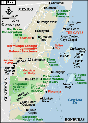
 Belize is located in the Caribbean. It has an estimated
population of 200,000. The average air temperature is 78
degrees and the water temperature is 80. Visibility is often 100 feet ore
more.
Belize is located in the Caribbean. It has an estimated
population of 200,000. The average air temperature is 78
degrees and the water temperature is 80. Visibility is often 100 feet ore
more.
 The main diving attraction is the barrier reef
(the second largest in the world) which is over 185
miles long. Another main attraction is the famous Blue Hole, which is part
of the lighthouse reef system. It is an almost perfect circular hole ½
mile across and 480’ deep. The cost of air fare and hotel is $2128
The main diving attraction is the barrier reef
(the second largest in the world) which is over 185
miles long. Another main attraction is the famous Blue Hole, which is part
of the lighthouse reef system. It is an almost perfect circular hole ½
mile across and 480’ deep. The cost of air fare and hotel is $2128
Little Cayman- The Cayman Islands lie in the center of the
Caribbean and are actually the tips of an undersea mountain. The average
air temperature is 82 degrees and the water temperature is 80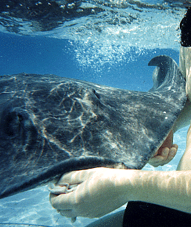 degrees.
Visibility averages 100 feet and peaks in the summer at 200 feet. The
attractions include vertical walls. The most popular being the Bloody Bay
Wall, named after a pirate battle, which drops off at 25’ and forms a
cliff that extends 6000’ deep! Another attraction is Stingray City which
is 12’ deep water where stingrays have become fairly tame. They came to
gather in that location because fisherman used the location to clean their
catch and the scavenger
stingrays would come to feed on the scraps. The cost of air fare and hotel
is $2074.
degrees.
Visibility averages 100 feet and peaks in the summer at 200 feet. The
attractions include vertical walls. The most popular being the Bloody Bay
Wall, named after a pirate battle, which drops off at 25’ and forms a
cliff that extends 6000’ deep! Another attraction is Stingray City which
is 12’ deep water where stingrays have become fairly tame. They came to
gather in that location because fisherman used the location to clean their
catch and the scavenger
stingrays would come to feed on the scraps. The cost of air fare and hotel
is $2074.
 Wailea
Bay, Hawaii is located in the Pacific Ocean on the island
of Maui. The air temperature averages 85 degrees and the water temperature
is 74. Visibility is around 70’. Dive attractions include an abundance of
large sea life including sharks, turtles, seals, dolphins and humpback
whales. The cost of air fare and hotel is $1901.
Wailea
Bay, Hawaii is located in the Pacific Ocean on the island
of Maui. The air temperature averages 85 degrees and the water temperature
is 74. Visibility is around 70’. Dive attractions include an abundance of
large sea life including sharks, turtles, seals, dolphins and humpback
whales. The cost of air fare and hotel is $1901.
 Truk Lagoon, Micronesia is a site that is the final resting
place for 70 Japanese ships and aircraft that were attacked in WWII. The
wrecks are covered in coral and can provide endless hours (days, months…)
of exploration. The air temperature averages 82 degrees and the lagoon
water temperature averages 84 degrees. The visibility is 60’. The diving
attraction obviously is the wrecks. The cost of air fare and hotel is
$2790 (which includes 6 days of diving).
Truk Lagoon, Micronesia is a site that is the final resting
place for 70 Japanese ships and aircraft that were attacked in WWII. The
wrecks are covered in coral and can provide endless hours (days, months…)
of exploration. The air temperature averages 82 degrees and the lagoon
water temperature averages 84 degrees. The visibility is 60’. The diving
attraction obviously is the wrecks. The cost of air fare and hotel is
$2790 (which includes 6 days of diving).
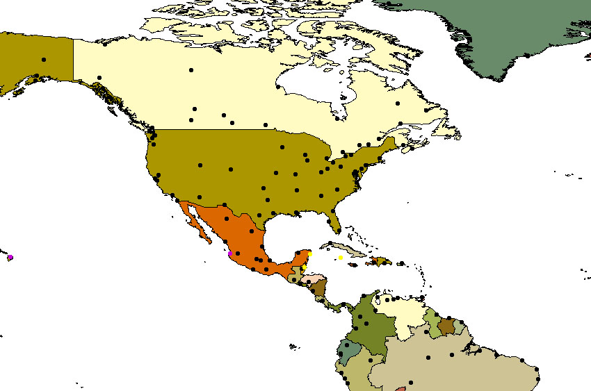
Air Temperature >= 75 and Water Temperature >=77 and Attraction >=4
Below is the screen display showing the 3 cities (highlighted in yellow) that met that criteria. Those cities are Cozumel, Belize and Little Cayman Island. Belize and Little Cayman had a diving attraction score of 5 so I narrowed my choice to those two.