| Mt. Diablo - GIS study to determine a maintenance corridor |
|
|
Author
Randy Fortner American River College, Geography 350: Data Acquisition in GIS; Spring 2004 Contact Information (email: calwld@california-wildlife.com) |
|
|
Abstract
Mt. Diablo State Park has a great diversity of plants and wildlife. The product from this project is the determination of a corridor to maintain the park’s recourses. The opportunity for expansion eastward and link to other public lands for the support of maintenance is feasible. | |
|
Introduction
The purpose of this project is to find a corridor to link Mt. Diablo State Park to other public lands. The purpose of a corridor is to assist in maintaining the parks resources. Expansion from housing development is surrounding the park. The expansion could prevent required maintenance of the park.  Landsat imagery false color composite created from bands 1, 2, and 3
Expansion from housing development is surrounding the park Communities in California have experienced population growth at accelerated levels between 1950 and 2003. Development resulting from this growth had severe impacts to the quality of the environment. Predictions of future growth from immigration have double the population in 40 years. Future growth will only increase the impacts to resources such as parks, open space, water, wetlands, and forests. The need to understand maintenance requirements of ecosystems and their subsystems is important to long-term ecosystem health. Ecosystems that make up California's parks, open space, or mitigation banks have unique needs. California systems require a healthy mosaic of different types and age classes of vegetation to support the system. Dense vegetation creates competition for ground moisture and lack of moisture weakens or kills trees and vegetation. Raptors preying on small rodents can’t protect their wings while trying to fly and maneuver in dense decedent vegetation. When raptors are inhibited from hunting, small rodents populations increase while raptor populations such as owls, eagles and hawks decrease. Deer and other herbivores need native grass and forbs to graze. Forbs that support wildlife loose space to grow from overcrowding and diversity of species are reduced in dense vegetation. In turn, fuel builds up across large areas and creates conditions for intense catastrophic fire within a system. Intense fire within homogenous landscapes lacks the ability to meander. 
Without different age classes of vegetation, landscape becomes very dense and homogeneous. Historically, fires originated from lighting or native inhabitants, and meandered through a healthy ecosystem. Diverse systems with a mosaic of different age classes encourage a fire's ability to meander. Fire is prone to follow fuel, which is made up of diseased, dry, dead vegetation, causing temperature and flame length to increase based on the density and types of fuels available. A dense decadent patch of vegetation has a lot of old dead branches and the ground is full of litter. Areas with more fuel encourage fire to enter, and as the fire enters the areas and spreads out, it consumes the fuel. Vegetation with a lot of dead material cannot resist being consumed by the fire. A young patch of healthy vegetation previously exposed to fire, or that has re-grown in an area exposed to fire, has significantly less ground litter and fewer dead braches. Therefore, it is more difficult for fire to burn in patches of young healthy vegetation. Fire meanders through a healthy system consuming the fuel and avoids or spares healthy vegetation. The natural fire cycle maintains a healthy system and fire is essential for maintenance.(1) 
A dense decadent patch of vegetation has a lot of old dead branches and the ground is full of litter Fire without the ability to meander or when fire is suppressed, the lack of natural meandering fire in a system creates a series of events that hinders or destroys a system's ability to maintain diversity in plant and animal life. A decedent homogenous landscape sets a stage for catastrophic fire. Fire is attracted to the fuel and spreads rapidly across large areas that continually provide fuel. Intense fires consume nearly all vegetation. 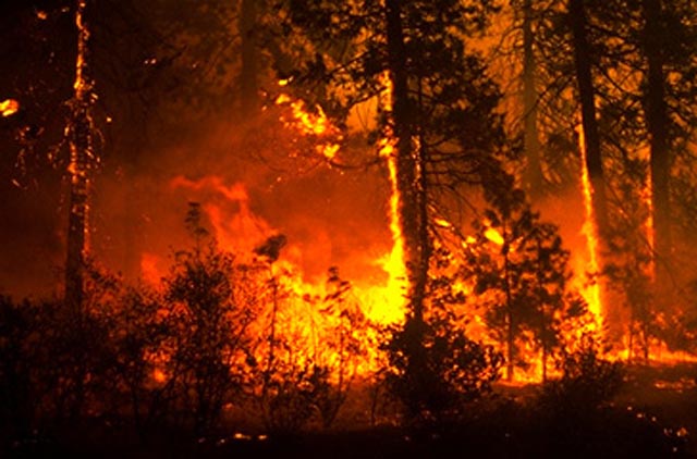
A decedent homogenous landscape sets a stage for catastrophic fire. Mosaics of vegetation help prevent erosion. The intense heat change soil characteristics and creates a very loose layer of topsoil. The loose top layer of soil or loss of ground cover promotes landslides and erosion. During a storm erosion will silt up creeks and springs and can change their characteristics that support wildlife. Topsoil that is needed for re-growth and contains nutrients with seeds is washed away. Re-growth is hindered by the loss of seed and topsoil. Grasslands can take the place of preferred vegetation. Grassland promotes more frequent fire. The return of similar vegetation and trees is restricted from the fire frequency. When large areas consumed by fire grows back, a young homogeneous landscape is created. The landscape matures at the same rate. That can set a stage for fire to reoccur and if reoccurrence is frequent the vegetation is replaced with other varieties. These changes reduce or eliminate habitat that was a part of a preexisting ecosystem. Wildlife is no longer able to sustain healthy populations. The landscape no longer contains the wildlife or vegetation covers that were preferred for preservation or needed to make up a healthy ecosystem. The intent to preserve natural resources in parks such as native grasslands, forbs, raptors and wildlife is not realized from the lack of consideration to plan for maintenance of the ecosystem. The most difficult requirement to fulfill in creating a corridor to expand Mt. Diablo is the fire maintenance element. A proposed corridor would serve little purpose if the preservation of the ecosystem were not realized. California Law requires the preservation of the ecosystem as an element of environmental review.(1) |
|
|
Background
California Vegetation Data (Gap Veg) was used to assist in location of habitat. The themes were: Annual Grassland Barren Blue Oak Woodland Blue Oak-Foothill Pine Chamise-Redshank Chaparral Coastal Oak Woodland Coastal Scrub Cropland Deciduous Orchard Estuarine Eucalyptus Freshwater Emergent Wetland Lacustrine Mixed Chaparral Montane Hardwood Orchard and Vineyard Pasture Riverine Urban Valley Oak Woodland Valley-Foothill Riparian There were four footprints used from spot imagery to provide background features. Lansat imagery was used to analyze bands within inferred wavelengths. Then a method used to identify vegetation was an algorithm called isoclustering. Ground proofing is ongoing and will be used to try and perfect data. Trimble recons were used for accuracy and to collect data. ESRI software called pathfinder was used to create data dictionary to organize data collection. The Internet was used to collect data for public land ownership. The files are used for fire response. The reports used as reference to influence the purpose of maintenance: Wildland Fire Patch Dynamics in the Chaparral of Southern California and Northern Baja California written by Richard A. Minnich and Yue Hong Chou. Forest and Range Assessment, Department of Forestry, Fire Resources and Assistance Program, written by their staff Evolution of California’s Wildland Fire Protection, C. Ramond Clar, State Forester (first State Forester) |
|
|
Methods
There were four major factors to consider in selecting a corridor for acquisition: · Species of Concern and wildlife preservation · Vegetation that supports species of concern · Vegetation that represent the natural ecosystem · Landownership · Maintenance of ecosystems within the park The species of concern is a factor to consider in the acquisition. Species of concern have specific habitat needs. Therefore type and amount an area contained of preferred habitat is a factor. Maintenance of habitat for the park is a major factor. The dominating and most difficult need of maintenance is vegetation. Fire is needed to maintain the ecosystem. Consideration for fire was an influence. What and how would fire play a part of the park? Fire control needs proper influence from weather. Cool humid conditions and westerly winds provide the best conditions for fire. The preferred direction for a corridor is easterly. The cost of a land acquisition is a major factor. The feasibility of an acquisition would depend on cost. Areas that aren’t developed are a factor to weigh the direction of a corridor. The linking of public land ownership is a consideration for a corridor. There is no cost associated with land already owned by the public and used for parks. Resources United States Geological Services · Quad Maps · Soils studies http://www.usgs.gov/ United States Census · Demographic and Land Use Information and Polygons http://www.esri.com California Department of fish and Game · California Natural Diversity Data Base http://www.dfg.ca.gov/whdab/html/cnddb.html California Department of Forestry – Fire Resources and Assistance Program · Vegetation Studies · Land Ownership · Habitat Studies and land use http://fire.ca.gov/frap National Aeronautics and Space Administration · Imagery –Landsat http://casil-mirror1.ceres.ca.gov/casil/gis.ca.gov/landsat7/ http://landsat.gsfc.nasa.gov/ http:// nasa.gov/home/index.html Alan Kilgore For his assistance in using ArcInfo to take landsat imagery and convert to veg polygons. Satellite Landsat imagery was used to determine vegetation types. The process used to analyze the bands that provided inferred values was a algorithm called Isoclustering. |
|
|
|
|
|
Results
The land located to the southeast of Mt. Diablo contains the element of public land ownership. The preferred dominate vegetation types for habitat preservation was southeast. However, there was a large amount of habitat southwest. The ability to acquire local land records to determine how to link the park hindered analysis. The problem with southwest was development. Large areas of development disconnect the park form the habitat. The link is worth additional exploration. There was habitat located northeast that is worth exploring. The ability to protect the park is hindered from the habitat not in public ownership and directly connected to the park. There should be a maintenance plan that includes similar habitat located northeast. The lack of maintenance would have negative affects on the park. The one noteworthy fact that should exclude discounting any of the preferred habitats from target, the land types are very rare and the resource is needed for the preservation of species and the park. The isolation of resources will create problems for the preservation Mt. Diablo. Parks East or adjacent: Areas such as golf coerces were looked at for fire control BLACK DIAMOND MINES REGIONAL PRESERVE LIME RIDGE OPEN SPACE CLAYTON COMMUNITY PARK BOUNDARY OAK GOLF COURSE DIABLO SHADOWS PARK MOUNT DIABLO STATE PARK MITCHELL CREEK PARK ARBOLADO PARK RUSSELLMANN PARK SHELL RIDGE OPEN SPACE DIABLO FOOTHILLS REGIONAL PARK COUNTY FARM REHABILITATION CENTER OLD MARSH CREEK SPRINGS CASTLE ROCK REGIONAL PARK SHELL RIDGE OPEN SPACE ROUND VALLEY PARK ROUNDHILL GOLF & COUNTRY CLUB EAST BAY REGIONAL PARK OPEN SPACE MORGAN TERRITORY REGIONAL PARK OAKHILL PARK DIABLO COUNTRY CLUB BLACKHAWK COUNTRY CLUB - FALLS (WEST) BLACKHAWK COUNTRY CLUB - LAKESIDE BRET HARTE PARK BLACKHAWK COUNTRY CLUB - FALLS (WEST) BLACKHAWK COUNTRY CLUB - LAKESIDE SYCAMORE VALLEY OPEN SPACE 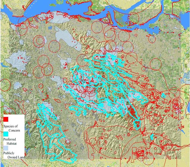
|
|
|
Figures and Maps

There were four footprints used from spot imagery to provide background features. Lansat imagery was used to analyze bands within inferred wavelengths. Then a method used to identify vegetation was an algorithm called isoclustering. Ground proofing is ongoing and will be used to try and perfect data. Trimble recons were used to collect data. ESRI software called pathfinder was used to create data dictionary to organize data collection. . 
|
|
|
|
|
|
Analysis
The use of Environmental Science Research Institute software called Arcmap afforded the polygon analysis of vegetation types, habitat, and landownership together to find a logical path to target park expansion. The selected habitat was chaparral, oak, and riverine. Landat remote sensing provided the bands used for analysis. Software called ArcInfo and a algorithm called isoclustering assisted in determining vegetation types. Ground proofing assisted in perfecting the identification of vegetation from the isoclustering products. The ArcInfo products were not used in the final analysis. I am still obtaining field information to learn the process. However a map was produced for the project. Trimble data collection devices were used to collect field point and polygons for vegetation identification and comparison of Archinfo or Cal Gap Veg data. Trimble software called pathfinder was used to create a data dictionary to organize the collection effort. Landsat imagery was used to create a false color composite from bands 1, 2, and 3: Red to 1, Green to 2 and Blue to 3. The composite provided a backdrop to locate features. Hillshade was created and used as a backdrop with the composite. Transparency of 30 % was applied to each of the layers used to create visual maps. Photographs were taken with time signatures. That allowed linking the photos to points or polygon gathered with Recons. The major problem with a project of this type is imagery resolution. Satellite imagery has limitation. However, aerial imagery is an expensive option for student work. Land Parcel information was not obtainable. State laws require the reporting of five attributes for tax purposes. The laws are old and the data does not support land planning. Public Land Information was obtainable. |
|
|
Conclusions
Fire is the most difficult element of maintaining an ecosystem. Because nearly all of California’s ecosystems are fire dependent, fire must be included in a maintenance or expansion plan. The need to inventory land ownership, spatial characteristics such as types of ecosystems and their subsystems, terrain and how to maintain them is important to the long-term health of Mt. Diablo State Park or any areas set aside for preservation. Without carefully evaluating the maintenance needs of an ecosystem, future acquisitions could create maintenance problems. The area could lose the characteristics that made the area desirable for preservation.Fire that is of good quality for Mt Diablo would ignite and spread from west to east. Intense fire that is influenced by weather spreads from north to south or east to west. Land that is located east of Mt Diablo seems appropriate for linking the park to other publicly owned lands. The area is composed of large tracks chaparral, and oak. Large areas of non-native grasslands are located beyond preferred habitat. However, there are pockets of native oaks, chaparral and riverine habitat. There were areas located southwest that were desirable. However, the influence of maintenance created the conclusion to expand the park east and link up public lands to the ecosystem. References
Reference #1 Wildland Fire Patch Dynamics in the Chaparral of Southern California and Northern Baja California written by Richard A. Minnich and Yue Hong Chou. Reference #2 http://www.leginfo.ca.gov CALIFORNIA GOVERNMENT CODE, SECTION 65350-65362, 65350. Cities and counties shall prepare, adopt, and amend general plans and elements of those general plans in the manner provided in this article. Reference 2 http://www.leginfo.ca.gov CALIFORNIA GOVERNMENT CODE, SECTION 65950-65957.5, 65950. (a) Any public agency that is the lead agency for a development project… PUBLIC RESOURCES CODE, SECTION 21100-21108, 21100 …(c) There is a need to understand the relationship between the maintenance of high-quality ecological systems and the general welfare of the people of the state, including their enjoyment of the natural resources of the state. (g) It is the intent of the Legislature that all agencies of the state government which regulate activities of private individuals, corporations, and public agencies which are found to affect the quality of the environment, shall regulate such activities so that major consideration is given to preventing environmental damage, while providing a decent home and satisfying living environment for every Californian. 21001.1. The Legislature further finds and declares that it is the policy of the state that projects to be carried out by public agencies be subject to the same level of review and consideration under this division as that of private projects… CALIFORNIA CODE, PUBLIC RESOURCES CODE, SECTION 21150-21154 … Reference #1 http://frwebgate4.access.gpo.gov/cgi-bin/waisgate.cgi?WAISdocID=4336754734+2+0+0&WAISaction=retrieve TITLE 42--THE PUBLIC HEALTH AND WELFARE, CHAPTER 55--NATIONAL ENVIRONMENTAL POLICY, Sec. 4321. Congressional declaration of purpose, The purposes of this chapter are: To declare a national policy which will encourage productive and enjoyable harmony between man and his environment; Reference #4 CALIFORNIA CODES, PUBLIC RESOURCES CODE, SECTION 21000 (c) There is a need to understand the relationship between the maintenance of high-quality ecological systems and the general welfare of the people of the state, including their enjoyment of the natural resources of the state. |
|