GIS : A Marketing Tool For Family And Social Services | |
|
Author Bernard Kelly American River College, Geography 350: Data Acquisition in GIS; Spring 2004 Contact Information (email: ezbkell@aol.com) | |
|
Abstract Use GIS tools to enhance PowerPoint presentations which promote in-house Programs at Wings Of Refuge. Provide GIS demographic services thru Website. | |
|
Introduction Wings of Refuge, Incorporated, is a non-profit, family services agency primarily funded by the state of California. One of their services is to provide families with placements for children in the foster care system. They wanted a way to enhance their presentations to promote donations and grants. Using GIS with current demographic data as a marketing tool. Output from GIS is used in PowerPoint presentations to show disparity between service planning areas (SPA) in the Los Angeles area. As an outgrowth, GIS data will enhance the company's Website, provide GIS Services to other SPA's, support other programs like Home Ownership, Anger Management, Kidds Kloset, Wings to Recovery, and Stabilizing Families. None of these programs are funded by the state. | |
|
Background Renee Moncito: President and Founder: Wings of Refuge Inc, a state of California licensed non-profit corporation with offices in Los Angeles and Palmdale (www.wingsofrefuge.org). My role: Bernard Kelly, Chief Technology Officer, Webmaster, Network Administrator | |
|
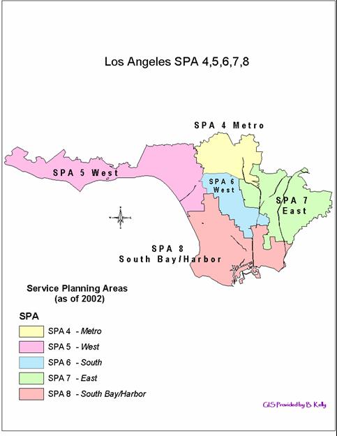
Methods Find someone with Company business knowledge and good computer skills that also has an interest in GIS. Some social services background would be a plus. Train that person in GIS Best curriculum west of the Rockies at American River College, so I moved to Sacramento. I'm able to attend school and support Wings from my home office. I love it! Do some research and homework. Determine guidelines and data methods. Selected data sources: United Way of greater Los Angeles (they are investing in programs that bring learning, empowering, and caring to those who are trapped in a cycle of poverty); and The Los Angeles County Children's Planning Council - a countywide public/private collaborative - dedicated to improving the lives of children and families by encouraging partnerships, promoting the use of data, developing resources and tools, and emphasizing the importance of outcomes and results. They also produce demographic data. More importantly they have divide Los Angeles into eight service planning areas (SPA). These spa's contain multiple cities and run along ZIP code boundaries. | |
|
Results From the California zip code data we were able to produce the base map (below) displaying only the Los Angeles Service Planning Areas (SPA) which border SPA 8. | |
 | |
|
Analysis Waste of time to try and find good "free" data on the web; most often, demographic data is outdated, due to the lengthy time required to take surveys and compile them. | |
|
Conclusions The demographic visual displays produced by GIS provided clear views, some insight and projected disparities between the SPA. | |
|
References
Renee Moncito, Wings of RefugeLos Angeles County Children's Planning Council United Way |