| Title Where in Sacramento is Affordable Housing? | |
|
Author Jessica Riggs American River College, Geography 350: Data Acquisition in GIS; Spring 2004 Contact Information (jbrandt@treasurer.ca.gov) | |
|
Abstract An analysis of affordable rental housing in Sacramento: why it is needed, how it is funded (focusing on tax-exempt bond financing), the variety of locations and forms in which is it found, and how use of GIS tools can assist with future affordable development. | |
|
Introduction In this paper I will conduct an analysis of recently bond-funded low income housing in Sacramento. The questions I wish to answer are what impact Federal Tax-Exempt Bond funding has on the local stock of low-income housing and where these affordable units are located. From my work as a bond-financing analyst, I believe that our funding program has had a substantial affect. To prove my theory, I will research apartment complexes located in the City of Sacramento that have utilized bond funding. With those results, I will map the complexes to show their number, which will also give a visual representation of where these units are located. Then I will create a table of the number of units made available for low-income tenants. In addition, to give those unfamiliar with the low-income housing that my agency helps to fund, I will provide descriptions of illustrative properties. | |
|
Background Living in California is getting increasingly expensive in many areas. The most visible rise in costs seems to be the price of buying a home. A November 2003 article in Mortgage Banking points out the California Association of Realtors’ Housing Affordability Index showed that just 23% of California households were able to afford a median-priced home. Implied in this statistic are two realities: that many of those unable to buy a median-priced home opt to rent instead of move to distant affordable suburbs, and many of those that rent also face expensive rental rates. Rental affordability is not a new problem. Over the past fifty years, government has struggled with how best to assist those with limited income in expensive rental areas. In the 1960’s and 1970’s the federal government created monolithic public housing structures to house those left out of the market. These government-run complexes soon showed themselves to be social and fiscal disasters, and most were destroyed. In their place the federal government began giving private investors tax breaks, tax-exempt bonds and other incentives to produce affordable housing. By enlisting private investors looking for a long-term investment, the government hoped to produce better quality housing for those in need. In 1984 the Federal government put a cap on the amount of tax-exempt private activity bonds that may be issued in each state. The California Debt Limit Allocation Committee (CDLAC) was designated as the entity to allocate the state’s tax-exempt bond ceiling to developers. The bonds are purchased by the private sector and the repayment is not an obligation of the state or of the federal government. These bonds assist developers of multifamily rental housing units to acquire land and construct new units or purchase and rehabilitate existing units. The tax-exempt bonds lower the interest paid by the developers. The developers in turn produce market rate and affordable rental housing for low and very low-income households by reducing rental rates to these individuals and families. CDLAC has allocated tax-exempt bonds to fund hundreds of projects throughout the state and dozens in the Sacramento area. The demand for available bond financing increases each year. Units created throughout the state for low-income renters number in the tens of thousands. | |
|
Methods To start, I gathered data from the CDLAC database and files on complexes located within the City of Sacramento, their year of funding and addresses. Because dozens of complexes have been funded over the past twenty years by CDLAC, I only gathered information on those funded in 2002 and 2003. The findings are summarized in table form. Of those properties found for the past two years in Sacramento, I chose to further describe three, to put a face to a name, so to speak. Second, I utilized the City of Sacramento’s General Map tool to locate the select complexes. Utilizing this publicly available GIS tool allowed me to gain a spatial understanding of the select complexes, increasing my understanding further. The City of Sacramento provides an excellent GIS resource. 
| |
|
Results 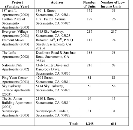
Table of funded projects in the City of Sacramento |
|
|
Figures and Maps
Example ProjectsPing Yuen Center Apartments This Project is an acquisition and rehabilitation of a vacant building located in an area historically referred to as “Chinatown” in Downtown Sacramento. Originally built in 1969, the Project is a four-story concrete, 79-unit apartment building with ground floor and basement level commercial space. The Project Sponsor will increase the number of units to 82 while maintaining the ground floor and basement retail and commercial uses. The Project is designed to serve low-income senior tenants, and will house a senior center on a portion of the ground floor. 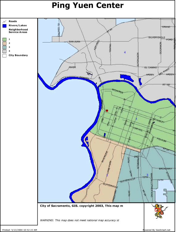 Sky Parkway Terrace Apartments The project is located in the County of Sacramento. It is a wood frame stucco exterior three-story building with an elevator. The project is a Federally Assisted/At-Risk project, which consists of 58 1-bedroom units. This building was built in 1978. The site is level, rectangular shaped and contains 1.64 acres. The project has an office, community room, laundry room and 35 open parking spaces. The area is mixed with single- and multi-family residential development and commercial, retail and office uses located along major thoroughfares. It is designed to service the local low-income senior community. 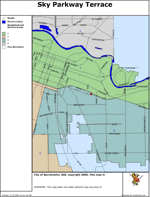 Natomas Park Apartments The project is located in North Natomas in the City of Sacramento. It is a new construction mixed-income complex. It will consist of 210 units of 1, 2 and 3-bedrooms. The area is a new growth planned development, with a mix of residential, retail and commercial developed or planned. The complex is designed to service local mid to low-income families. 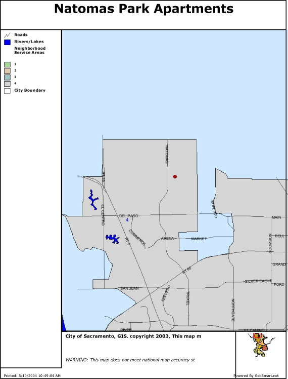 | |
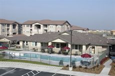 |
A view of Natomas Park Apartments |
|
Analysis These numbers and illustrative examples
clearly show that the tax-exempt bond funding is making a significant difference in the
creation of mid- and low income housing in Sacramento. The maps and examples provided
also show how diverse geographically and in mode of use each project is. Each project
blends into its neighborhood, as they are built to attract renters and produce profits for
investor in the long term. The privately funded projects assisted by CDLAC are not the
monolithic public-housing projects of many imaginations. The success of these projects,
over 600 affordable units created in the last two years, means that Sacramento will have a
better chance of assisting those left out of the booming housing market. | |
|
Conclusions GIS gives us the ability to observe where
the affordable housing units CDLAC helps fund are located, both individually and in
relation to one another. While as a rule, CDLAC does not track the relative distance
between funded projects, we might do well to start. Concentrating affordable housing
projects in one area could lessen property values in that area, the choices for low-income
renters, and the appeal of affordable housing. Utilizing the tools of GIS would help
prevent these negative consequences. | |
|
References Literature cited. Fogarty, Thomas A. “First Time Buying a Home? Good Luck, in this market. Skyrocketing prices in large areas make dreams seem unreal.” USA Today. 22 October 2003. {Sacramento Library On-Line Catalog.}. “Housing Affordability in California Drops.” Mortgage Banking. November 2003. Pg. 17. http://gis.cityofsacramento.org/website/sacgeneralmap/ default.asp. Accessed on 13/5/2004. www.treasurer.ca.gov/cdlac. Accessed on 22/4/2004, 13/5/2004. | |