| Cooling Sacramento | |
|
Author Susan Salley Veazey
American River College, Geography 350 Data Acquisition in GIS; Spring 2004 ssalley@pacbell.net | |
|
Abstract “Cooling Sacramento” presents a general description of the Global Warming phenomenon, the effects of land cover change on climate, and efforts specific to Sacramento to reduce the impact of urban heat islands. | |
|
Introduction In the words of Joyce Kilmer, “I think that I shall never see, a poem lovely as a tree…” With a background in urban planning and most importantly as a native Californian, I have long been interested in patterns of growth in my home state. Specifically, our tendency to build sprawling auto-reliant communities which convert productive agricultural and natural resources to tract housing and strip malls. At some point in my intellectual development I hope to deepen my understanding as to why these growth patterns exist, but for purposes of this paper I am looking the effects of this type of development on public health. Specifically, how does the pattern of growth impact our local climate? What is our community’s part in the Global Warming phenomena? My search for answers looks like an upside down pyramid beginning with the Earth’s atmosphere and ending with an urban shade tree. | |
|
Background Global Warming The term “Global Warming” relates to an increase in the average temperature of the Earth's surface that occurs following an increase in greenhouse gases caused by human activity. The consequences of global warming are profound for both human beings and the ecosystems which support all life on earth. Average sea levels may rise, rainfall patterns may change, agriculture will be affected by temperature, soil and moisture changes, and water resources will be threatened. Global warming will result in more air pollution. Heat waves will be longer and more intense as will storm systems. Forests, farms and cities will face troublesome new pests and more mosquito-borne diseases. The most direct public health effect of global warming is the impact of hotter temperatures. People die when the climate becomes very hot. A human heart must work harder to keep the body cool during hot weather; therefore, individuals with cardiovascular problems are at risk. Health problems associated with heat exhaustion and respiratory problems also increase. Higher temperatures lead to greater demand for energy to cool buildings and cars, higher expenses for energy and gasoline, and more atmospheric pollutants. The rate of smog (i.e., a mixture of particulate matter and chemical pollutants in the lower atmosphere) formation increases with temperature, so that on hotter summer days pollutants in the air “cook” producing higher ozone levels. Ozone is a harmful pollutant that at increased concentrations at the ground level damages lung tissue and causes particular problems for people with asthma and other lung diseases. Even modest exposure to ozone can cause healthy individuals to experience chest pains, nausea, and pulmonary congestion. In much of the nation, a warming of four degrees (F) could increase ozone concentrations by about 5 percent. Land Cover Changes Land-use and land-cover change is linked in complex and interactive ways to global climate change. Changes in greenhouse gas emissions, albedo, (i.e., the ratio of the amount of light reflected by an object), and surface roughness are the primary mechanisms by which land-use and land-cover change affect climate. Strong links between land cover and climate therefore mean that changes in land use can be important contributors to climate change and variability. By replacing vegetation and soil with concrete and asphalt, we reduce the landscape’s ability to lower daytime temperatures through evapotranspiration (i.e., the total amount of water that is transferred from the earth's surface to the atmosphere, made up of the evaporation of liquid or solid water plus the transpiration from plants) and lose the obvious benefits of shade. According to the Great Valley Center’s State of the “Great Central Valley of California”, urbanization rates are continuing to increase in most Central Valley growth areas. The Sacramento Valley has converted thousands of acres from agricultural to urban use in just the last decade. While California’s air quality overall has been improving for the past 30 years due to greater emissions controls, those improvements have not been reflected in the Central Valley where poor air quality has remained essentially level. GIS and Land Cover My hope in undertaking this project was to discover intriguing uses of GIS which might be used to assist regional planners in regulating growth in a manner that decreases the effects of land conversion on public health. While I did not find exactly what I had hoped to, I did find that those who are studying the problem of global warming are also interested in such uses for GIS. The U.S. Global Change Research Program (USGCRP) was created by the Global Change Research Act of 1990 to support “research on the interactions of natural and human-induced changes in the global environment and their implications for society.” The program is mandated to coordinate the efforts of all of the relevant federal government agencies. Chapter 6 of the USGCRP’s Strategic Plan for the Climate Change Science Program (July 2003) lays out the questions related to land use and land-cover change. According to the Strategic Plan, “the interaction between land use and climate variability and change is poorly understood and will require the development of new models linking the geophysics of climate with the socioeconomic drivers of land use.” The Strategic Plan calls for the integration of ground-based and remote sensing data collection systems to improve the speed and quality of land-cover data. Among other improvements in geographic modeling, the Strategic Plan recommends the development of “coupled climate-land use/cover models.” Urban Heat Islands A heat island is an urban area that is hotter than the surrounding countryside due to a lack of trees and vegetation. Trees, grass and shrubbery are removed and replaced by dark, horizontal, impervious materials such as asphalt and roofing. Dark surfaces absorb heat during the day, raising temperatures and triggering the chemical reactions that produce smog. Most cities in the United States form heat islands with temperatures between two and ten degrees hotter than their surroundings. As an illustration, Los Angeles in 1934 was covered with irrigated orchards and warmed to high temperature of 97 degrees in the summertime. As buildings and pavement have replaced orchards, peak summer temperatures now rise to 105 degrees and higher. | |
|
Results The Sacramento Cool Community Program In 1997, the U.S. Environmental Protection Agency (EPA) began an initiative aimed at quantifying the potential benefits of Heat Island Reduction strategies to reduce air conditioning use in buildings, lower air temperature and improve air quality in cities and reduce CO2 emissions from power plants. This “Heat Island Reduction Initiative,” was comprised of two projects; the Urban Heat Island Pilot Project and the Energy Star Roof Products Program. Individuals at the Sacramento Tree Foundation learned of the EPA’s Heat Island Reduction Initiative and applied on behalf of the Sacramento Region to participate in the program. The Sacramento Region was selected as a demonstration site. The Sacramento Cool Communities Program was undertaken to implement the Heat Island Reduction Initiative’s demonstration project. The Cool Communities Program was undertaken by the Sacramento Tree Foundation in collaboration, as has been mentioned, with the EPA. The stated mission of the Sacramento Cool Community Program (SCCP) was to: “Improve the livability of the greater Sacramento area by reducing summer temperatures using shade trees and reflective surfaces, which in turn reduces energy use, greenhouse gas emissions, urban ozone levels, ultra-violet radiation exposure and storm water runoff.” The SCCP program promoted three key measures to reduce warm weather temperatures: 1) Trees and other vegetation to cool the city by shading buildings, parking lots, playgrounds, streets, etc. and cool the air by evapotranspiration. 2) Cool roof coatings and materials to reflect away the sun’s heat, keep buildings cooler and reduce energy use. 3) Cool pavement surfaces and materials to reflect away the sun’s heat, keep pavement cooler and reduce its heat storage. As a result of the EPA’s program, scientists at Lawrence Berkeley National Laboratory undertook a study of energy savings which would occur if heat island reduction mitigation measure were implemented. This March 2000 study found that Sacramento could save 26 million dollars (in year 2000 dollars) in energy costs for rate payers, avoiding 486 megawatts in peak power and a reduction in annual carbon of 92 kt. Heat island mitigation measures included strategically placed shade trees, use of reflective roofing materials, and use of reflective building materials on pavements and buildings. The study found that 23 percent of the overall savings was due to cooler ambient air temperatures. Maximum air temperature would be reduced by three degrees Fahrenheit if the mitigation measures were put into place. The study concludes that reflective roofing materials and shade trees offer the best benefit from a direct energy saving perspective. If energy savings is the goal, roofing and shade tree programs offer the best benefit. However, if air quality is the primary goal of the region, reflective surface materials which include roofs and pavement should have priority. The Cool Communities Program, which ended in the winter of 2002/2003, was successful on a number of fronts. The SCCP helped to develop a manual to improve the planting of trees in parking lots to help meet the 50% shading goal of the Sacramento parking lot shade tree ordinance. The SCCP lobbied to get “cool community” measures included in AB970 as an energy efficiency measure in response to California’s peak electricity problems. The SCCP worked closely with the California Energy Commission to translate the “cool community” funding into a working cool roof rebate program. This program was the precursor to cool roof rebates which are currently given out by California utilities. The work of the SCCP led to changes in the California building energy code which will include cool roofs as a standard/default measure for all new non-residential construction as well as requiring cool roofing on all re-roofs of non-residential buildings. The code does not make cool roofs mandatory, but builders will have to jump through hoops to get approval for use of non-cool roofing materials. The SCCP Strategic Plan makes several recommendations for on-going efforts to cool the region. With regard to trees and vegetation, the SCCP recommends demonstrating structural soils to improve tree root growth and prolong tree life. The major barrier to establishing trees in paved urban areas is the lack of soil volume for tree root growth. Soils under pavement are too highly compacted to permit tree roots from growing. Trees which survive these conditions tend to have roots which grow just below the pavement surface and ruin the sidewalk, street, etc. Structural soil is an innovative redesign which combines meeting load-bearing needs with encouraging root growth away from pavement surfaces. Also with regard to trees and vegetation, the SCCP recommends the development of a vine planter system to provide shade in areas where trees will not fit. The challenge for increasing the use of cool roofing relates to the availability of cool roofing materials for sloped roofs. Most residential buildings employ sloped roof architecture. Cool products suitable for residential buildings are among the most expensive available and are hard to find. At the time of the preparation of the Strategic Plan (July 1999), there were no affordable cool asphalt shingles on the market. Therefore, the SCCP recommended developing a pilot program which would bring together manufacturers, suppliers, roofers, and consumers to stimulate the production and purchase of residential cool roofing materials. Cooler pavement materials can result in a surface which remains 20 degrees cooler in the summer sun. At the time of the Strategic Plan, Sacramento was not using any cool paving materials for street and parking lot repaving. Because cool paving surfaces have been sufficiently developed, the SCCP recommended demonstration programs using various cool materials and paving techniques to repave Sacramento parking lots and then evaluate their cost effectiveness. |
|
|
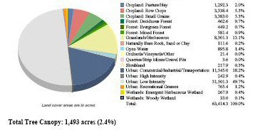
Analysis Urban Shade TreesAccording to Sara Ebenreck: “Trees outstrip most people in the extent and depth of their work for the public good. Twenty-four hours every day…they’re on the job creating an environment beneficial to our physical and mental health. They cool the air…Pollution cleanup goes on noiselessly…They cut our fuel bills and increase our property values.” According to the “City of San Francisco Street Tree Analysis Report,” urban trees provide air quality benefits in five major ways: 1) Absorbing gaseous pollutants through leaf surfaces. 2) Intercepting particulate matter. 3) Reducing emissions from power generation by limiting building energy consumption, 4) Releasing oxygen through photosynthesis. 5) Transpiring water and shading surfaces that lower local air temperatures, thereby reducing ozone levels. Studies show that tree loss is a major contributor to heat islands. Not only do trees provide shade but they give off water which helps cool the environment. Studies in Sacramento found that placing shade trees around buildings saved up to 60% of the building’s cooling energy. Trees “evapotranspirate” moisture through their leaves; removing heat from the air in the process. One mature, properly-watered shade tree with a 30-foot crown can process 40 gallons of water in a day. Shade trees over parking lots not only cool the parking lot climate and pavement surface, but limit vehicle temperatures that in turn reduce evaporative emissions from automobile gas tanks. Trees absorb and filter out nitrogen dioxide, sulfur dioxide, ozone, carbon monoxide and particulate matter of less than 10 microns in their leaves. Urban trees clean the air that directly affects the health of urban dwellers. In addition to improving air quality and temperature, trees improve water quality. Trees filter surface water and prevent erosion both of which maintain or improve water quality. GIS and Urban Shade Trees In conducting my research, I found two software packages designed to assist decision-makers with planning for urban tree planting. The first, CityGreen was developed by American Forests in Washington D.C. and is GIS based. The second, Street Tree Resources Analysis Tool for Urban forest Managers (STRATUM), is being developed by the Center for Urban Forest Research in Davis. STRATUM developers boast that their program is not GIS-based and is, therefore, more user-friendly. CityGreen is advertised as a “powerful GIS application for land-use planning and policy-making.” The software is designed to conduct statistical analyses of a region’s ecosystem. CityGreen calculates dollar benefits of trees based on site-specific conditions. The following are images produced by CityGreen for the City of Sacramento. The report concludes that the city’s total tree canopy is 2.4% of the land area or 1.493 acres. The estimated pollution removal provided by the trees is valued at $366,479. The report does not give an estimate of the value of ambient air temperature cooling. 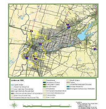
STRATUM, still in production, advertises that it “enables any community to conduct a street tree assessment that fosters community support in their program…” The program uses a sample inventory of existing trees to evaluate benefits, costs and management needs. | |
|
Conclusions “Think globally. Act Locally.” That building patterns affect climate change seems clearly established. Quantifying and communicating that link to the general public and land-use policy makers is the challenge. The use of urban shade trees is clearly beneficial as would be the required use of reflective roofing and paving surface materials. The larger issue is how communities accommodate increasing populations without such drastic changes in land cover that the doomsday scenarios presented by global warming specialists come to fruition. I am hopeful that effective GIS tools can be developed which can be used by regional planners to quantify the climatic and, therefore, public health impact of increased suburban sprawl not just from vehicle emissions but from land cover conversions. | |
|
References “Assessing the Region Via Indicators: The Environment,” Great Valley Center, Modesto, CA Center for Urban Forest Research, “Street Tree Resource Analysis Tool for Urban forest Managers; STRATUM.” Brochure April 2004. City Green Report produced by American Forests for the City of Sacramento. Estes, Maurice G., et al, “The Urban Heat Island Phenomenon and Potential Mitigation Strategies.” (National American Planning Association Conference, 1999) http://www.asu.edu/caed/proceedings00/ESTES/ESTES.HTM March 4, 2004 Garbese, Karina et al, “Controlling Summer Heat Islands: Proceedings of the Workshop on Saving Energy and Reducing Atmospheric Pollution by Controlling Summer Heat Islands.” February 23 – 24, 1989, University of California, Berkeley Gartland, Dr. Lisa, “1999-2000 Strategic Plan for the Sacramento Cool Community Program” July 1999 Gartland, Dr. Lisa, former director of Sacramento Cool Community Program, e-mail correspondence and telephone discussion held April, 2004 Hirsch, Alan, et al, “Frequently Asked Questions,” Sacramento Cool Community Program Steering Committee Konopacki, S. and H. Akbari, “Energy Savings Calculations for Heat Island Reduction Strategies in Baton Rouge, Sacramento and Salt Lake City,” Environmental Energy Technologies Division, Earnest Orlando Lawrence Berkeley National Laboratory, March 2000. Loveland, Tom et al, “Chapter 6: Land-Use/Land Cover Change.” Strategic Plan for the Climate Change Science Program, July 2003. www.usgcrp.gov/usgcrp/ProgramElements/land.htm Moll, Gary and Sara Ebenreck editors, “Shading our Cities: A Resource Guide for Urban and Community Forests,” pp 49-57 American Forestry Association, 1989 Rosenzweig, Cynthia et al, "Climate Change and a Global City: An Assessment of the Metropolitan East Coast Region." (June 19, 2000) http://metroeast_climate.ciesin.columbia.edu/reports/assessmentsynth.pdf February 12, 2004 Wade, Beth, “Putting the freeze on heat islands.” American City and County Feb. 1, 2000. | |