| Title Overview of Hamilton Army Airfield Wetlands Remediation Project | |||||||||||||||||||||||||||||||||
|
Author Lynn Razzini American River College, Geography 350: Data Acquisition in GIS; Fall 2004 Contact Information Lrazzini@aol.com | |||||||||||||||||||||||||||||||||
|
Abstract Portions of Hamilton Army Airfield, Novato, Ca are undergoing remediation and excavation in the process of development as a wetlands area. First used as farming land and later used as a military base, Hamilton Army Airfield requires some soil cleanup to create safe habitat for some sensitive wetland species living in the area. GPS coordinates were collected and input into a GIS database. Maps were created in ArcView. Analysis of mapped chemical data resulted in development of a workplan for soil sampling and excavation. Excavation is currently ongoing and expected to be completed in Spring 2005. | |||||||||||||||||||||||||||||||||
|
Introduction Some former military bases are being restored for public usage. Hamilton Army Airfield,Novato, CA, is one of those bases that is currently being investigated and remediated for reuse as a wetlands. The Hamilton Wetlands Remediation Project is anticipated to provide habitat for a variety of shore birds, migratory waterfowl and estuarine fishes. In order for that to be successful, contaminated material in the soil needs to be identified and the soil removed from the designated areas. In this paper a small portion of this wetlands has been examined and results are explained below. | |||||||||||||||||||||||||||||||||
|
Background Originally, the project area was primarily a tidal salt marsh. It was drained and farming began over 100 years ago. The Army Air Corps completed construction of Hamilton Army Airfield on this sight in 1935. It supported several types of aircraft during World War II and was used as a training field. In 1947, the newly formed US Air Force renamed the base Hamilton Air Force Base. The Army leased portions of the base until 1984 when 712 acres were transferred back to the Army. About half of this 712 acres has been transferred back to the City of Novato and is in the process of restoration to a wetlands. Some of the surface soils contain low levels of contamination in the form of the pesticide dichlorodiphenyltrichloroethane (DDT) and polycyclic aromatic hydrocarbon (PAH). | |||||||||||||||||||||||||||||||||
| In agreement with the San Francisco Regional
Water Quality Control Board in 2003, soil with DDT levels above 24 parts per
billion (ppb) or PAH levels above 4.02 parts per million (ppm) will be excavated
and relocated to the seasonal wetlands area away from sensitive wetlands species
like the clapper rail bird.
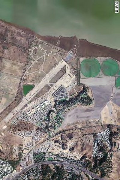
Sampling for DDT and PAH was conducted in the project area in 2003 and 2004. The analytical results of this sampling are described in the Soil Managment Plan for the Hamilton Wetland Restoration Project (USACE 2004). The aerial photo to the right is of Hamilton Army Airfield (Terraserver). The body of water at the top of the photo is the west side of San Pablo Bay. |
| ||||||||||||||||||||||||||||||||
|
Methods Geographic coordinates were collected using a Trimble unit and a Garmin unit and put into a database. Maps were created with ESRI ArcView software, and a workplan was developed for soil excavation and relocation. I had the opportunity to help collect GPS coordinates for several sampling grids in the project area. Samples were collected at the planned locations and sent off for analysis. The results are documented in publicly available reports (USACE 2004a, USACE 2004b). I also went to the project sight and took the excavation photos displayed below. | |||||||||||||||||||||||||||||||||
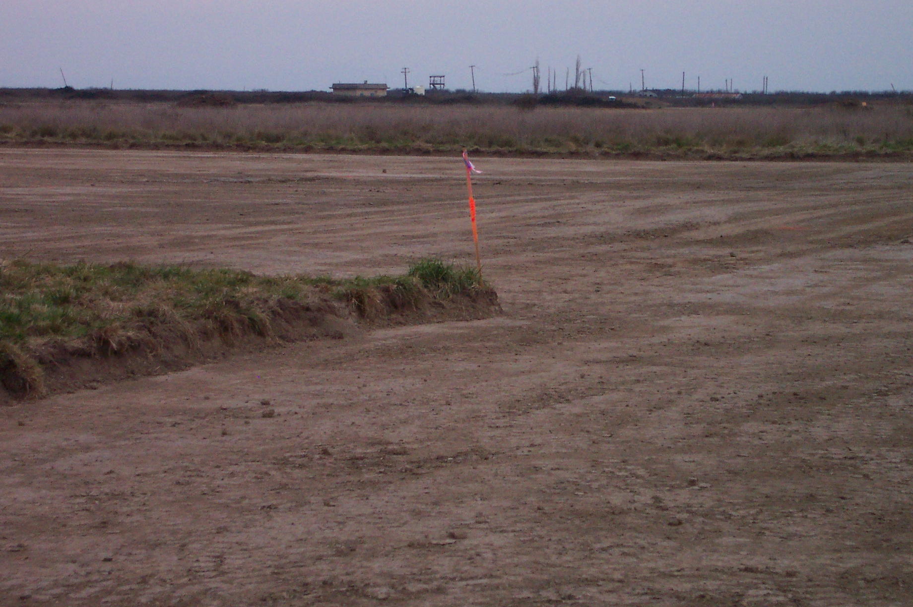
| I used the google search engine for websites containing information on Hamilton Army Airfield history and the current remediation. Additional information was taken from the soil management workplan described above and the remedial action workplan (ITSI 2004). Site remediation started Fall 2004. The photo to the right shows one small area of excavation. The orange flag marks one corner of a shallow excavation area that is about one foot deep. Samples will be collected from the new excavation surface to confirm sufficient material has been removed. If analytical results are below the action goals decribed above in the background section, excavation will be complete. If the results are above the action goals for either DDT or PAH, then excavation and confirmation sampling will continue until goals have been achieved. |
| ||||||||||||||||||||||||||||||||
|
Results Selected soil analyses for DDTs
and PAHs are shown on the tables below. Over 100 DDT sectors and over 100
PAH grids were analyzed for this restoration effort.
The soil sampling and excavation is a lengthy process but is much needed to ensure
that restoration of the wetlands meets the environmental goals.
| |||||||||||||||||||||||||||||||||
|
|
||||||||||||||||||||||||||||||||
|
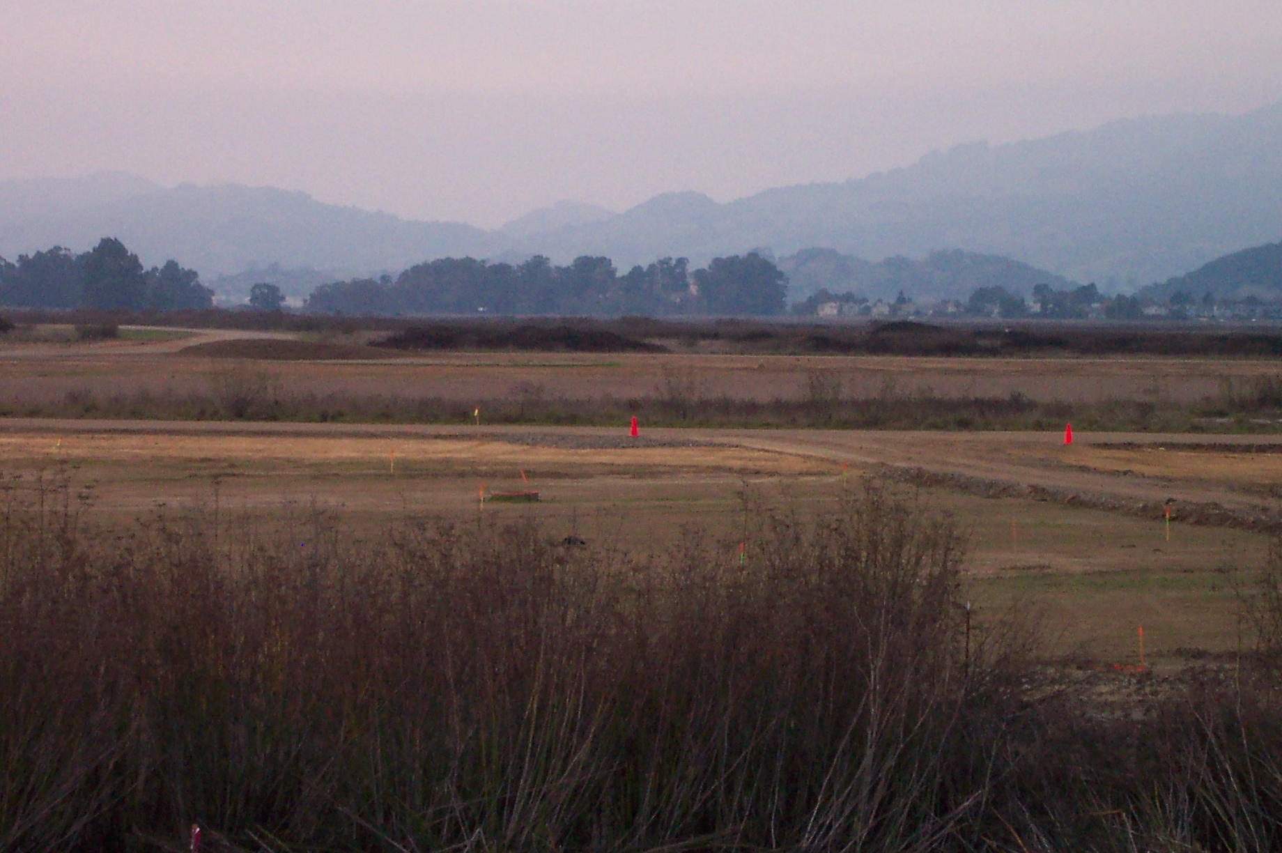
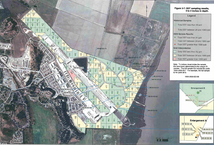
Figures and Maps The photo on the left below is
one of the areas being excavated. There are several depth lengths of the
excavation areas as noted in the tables above. The figure below
on the right is developed from ArcView for the soil management plan and displays all
of the DDT sectors sampled. Green indicates sample results <24 ppb. These sectors do
not need to be remediated. Yellow indicates sample results between 24 ppb and
1000 ppb. Soil from these sectors will be removed and relocated onsite. Red indicates
sample results >1000 ppb. Soil from these sectors will be removed and disposed of
offsite. | |||||||||||||||||||||||||||||||||
 |
 |
||||||||||||||||||||||||||||||||
|
Analysis Example analytical results
are as follows: DDT sector 7 is >24ppb at 0"-3", and <24 ppb at 6"-8". Excavation to 6"
was recommended in this sector.
PAH grid 1016 is >4.02 ppm at 0"-3", and <4.02 ppm at 12"-14". Excavation was recommended
to 12" in this grid. Approximately 25% of all the DDT sectors are being remediated
(ITSI 2004). Approximately one third of the PAH grids and some narrow strips near auxillary
roads are being remediated (ITSI 2004). Map datums NAD27 and NAD83 were the projections used
for mapping of the project areas. The projections were converted to NAD83 to allow viewing
with the same projection. Also, the project areas are in both CA State plane zone II and
zone III and also had to be converted to Ca State plane zone III .
| |||||||||||||||||||||||||||||||||
|
Conclusions The Hamilton Army Airfield remediation
project is well on its way to successfully converting this former military base
into a wetlands. However, there is still ongoing sampling and excavation to be
completed. GIS and GPS technology has been a great tool to help with data collection
and development of restoration plans on this project.
| |||||||||||||||||||||||||||||||||
|
References ITSI. Final Work Plan: Levee Construction and Soil Management for the Hamilton
restoration Project, Hamilton Army Airfield, Novato, Ca, August 2004
Map of Hamilton Army Airfield. Downloaded Nov 2004. www.terraserver.com USACE.2004 Soil Management Plan, Hamilton Wetland Restoration Project, City of Novato, Marin County, May 2004 USACE. Hamilton Army Airfield Wetland Restoration Feasibility Study. Downloaded Nov 2004. http://www.spn.USACE.army.mil/hamilton/ USACE. A Brief History of Hamilton Army Airfield. Downloaded Dec 2004. http://www.spk.USACE.army.mil/projects/environmental/haaf/ | |||||||||||||||||||||||||||||||||
|
| |||||||||||||||||||||||||||||||||