GPS versus Pedometer: A Relative Comparison
Author
Eric O. Simpson
American River College, Geography 350: Data Acquisition in GIS; Fall 2004
Email: simpsoe@zip.arc.losrios.edu or phytosaurman@cs.com
Fax: (916) 773-3047
Abstract
A pedometer and a GPS unit were used to measure the distance covered by a number of walking routes. While distance was the primary measurement, the focus of the study was to make a qualitative comparison between the two measurement methods. Routes that were not mapped proved as useful to the study as those that were map. The author's conclussion is that a pedometer is better suited to a short-distance walker who is not interested in the latest technology but is willing to perform frequent calibrations and a GPS unit is better suited to a long-distance traveler with technical knowledge.
Introduction
This project centers around the daily exercise routine of the family pets, "The Boys". The Boys are Harry, a Lakeland Terrier, and Toby, a Cairn Terrier. They get a walk almost every day. Normally, the walker, Mom, wears a pedometer to keep track of the distance she walks. The author followed the Boys on several walks while using a Garmin GPS unit to mark the route and produce an independent measurement of each walk distance to compare to the measurement produced by the pedometer. (Figure 1)
 The Boys: Harry (left) and Toby |
|
 Mom |
 The Author |
Figure 1: The Study Participants
Background
Pedometers are mechanical devices that the walker can wear on a wrist or ankle or clip to clothing. A pedometer contains a mechanical or electronic switch that registers a step whenever the unit accelerates. A computer in the unit multiplies the total number of steps by the calibrated stride distance to determine total distance walked [Marshall et al, 2003]. A GPS unit measures distance by linking together waypoints (fixed positions where the unit operator determined the exact location of the unit at that moment) into a route or track [Letham, 2001]. Garmin makes four models that can be worn like a pedometer, but each model measures distnace using GPS, not a motion-sensitive switch as with a true pedometer [Garmin.com].
Methods
For this study, the pedometer is a Sportline 342 Electronic Walking Pedometer sold under the Discovery Store label (Figure 2). The pedometer is clipped to Mom's warm-up shorts at waist level and calibrated to a stride length of 2.4 feet (28.8 inches) per stride (Mom is about 5' tall).
The GPS unit used by the author is a Garmin GPS 76 marine navigator (Figure 3). The first waypoint of each walking route, which is given the waypoint ID "HOME", is always marked at the same location (Figure 4). The final waypoint, "HOME2", is also measured here. The criteria for marking a waypoint during the walk are not exact. Generally, a waypoint is marked whenever the boys stop for a moment to sniff something, get a treat, or conduct "business". The author also marked any corner of an intersection that is traversed by the walk. Walking a considerable distance from the previous waypoint, traversing a curve path, or passing important landmarks also warrent the marking of waypoints. The GPS uses the NAD83 datum and the UTM Zone 10S coordinate system. Software limitations lead to the need to manually enter each waypoint's UTM coordinates into a spreadsheet in order to plot the waypoints in ArcMap 8.3.
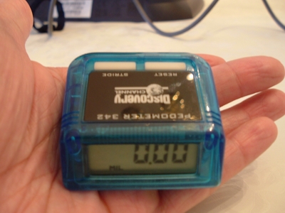
Figure 2: The Sportline 342 Electronic Walking Pedometer used in the study.
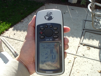
Figure 3: The Garmin 76 GPS unit used this study.
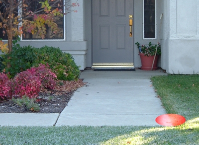
Figure 4: The center of the red circle shows the real location of the point where the HOME (first) and HOME2 (last) waypoints of every walk were marked.
The door in the picture is the front door to the author's house.
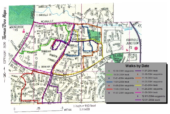
After each walk, the UTM coordinates of each waypoint are used to create a point shapefile in ArcMap 8.3. A polyline shapefile was then created within ArcMap for the purpose of drawing lines between waypoints to show the route as a continuous track to approximate the route covered by the pedometer. A basemap of the neighborhood was created by splicing together enlarged (2x) sections from four pages out of the Thomas Guide to Sacramento County (maps 219 and 239).[Thomas Brothers Maps, 2001]. Finally, key points and intersections were used to georefence the basemap to the routes (Table 1). The final map is shown in the Results.
| Intersection | Easting | Northing | |
|
Country Club & Baseline |
645203.500 | 4290578.000 | * |
|
Woodcreek & Junction |
644730.000 | 4291289.000 | |
|
Woodcreek & McAnally |
645062.000 | 4291917.500 | * |
|
Revere & Junction |
646208.500 | 4291314.500 | * |
|
Revere & McAnally |
646168.000 | 4291821.000 | |
|
Country Club & McAnally |
645730.250 | 4291882.750 | * |
|
Brookline & Legends |
645431.200 | 4261616.667 | * |
|
Country Club & Junction |
645356.688 | 4291061.063 | * |
|
Country Club & Legends |
645620.923 | 4291553.692 | * |
| * averaged from 2 or more waypoints | |||
Table 1: UTM coordinates and locations (intersections) of georeferencing points.
Results
click here for larger map
)
Figure 5: Project map showing waypoints and tracks mapped for each walk.
| Date |
GPS Distance (miles) |
Pedometer Distance (miles) |
Difference (absolute) |
Difference (ped-GPS) |
| 10/30/2004 | 1.75 | 1.79 | 0.04 | 0.04 |
| 11/01/2004 | 1.75 | 1.42 | 0.33 | -0.33 |
| 11/05/2004 | 2.37 | 2.62 | 0.25 | 0.25 |
| 11/07/2004 | 1.94 | 2.07 | 0.13 | 0.13 |
| 11/16/2004 | 2.26 | 2.38 | 0.12 | 0.12 |
| 11/23/2004 | 2.08 | 2.36 | 0.28 | 0.28 |
| 11/29/2004 | 2.28 | 2.18 | 0.10 | -0.10 |
| 12/01/2004 | 2.11 | 2.42 | 0.31 | 0.31 |
| Average Difference | 0.20 | 0.09 | ||
Table 2: Comparison between results from the GPS unit and the pedometer regarding distance covered by each walk.
Analysis
There is no apparent pattern regarding the difference between the results from the pedometer and those from the GPS unit, except that the GPS unit has a tendency to record a longer distance. The lack of an absolute distance means there is no standard for distance comparison, so it is impossible to tell with certainty which method is more accurate.
There are two additional walks that were not used because the methods produced measurements that differed by a half-mile or more. The data from 11/27/2004 were acquired with a substitute walker using an improperly calibrated pedometer. The GPS unit yielded a distance of 2.25 miles, while the pedometer yielded a distance of 1.63 miles. This route was retraced with Mom and a properly calibrated pedometer on 11/29/2004. The data from 11/30/04 were acquired with the normal participants, but while the GPS unit recorded a distance of 2.07 miles, the pedometer yielded a measurement of just 1.43 miles. The most likely cause of the discrepency is the pedometer was worn on a different location on the body (a few inches above the waist instead of at waist level) and was attatched to jeans instead of the normal warm-up shorts, which are looser and more responsive to body movement. The pedometer was also recalibrated before additional walks, just in case this also contributed to the discrepency. This route was retraced on 12/01/2004.
Conclusions
Pedometers and GPS units are both capable of recording distance. Each measurement method has its strengths and weaknesses.
Pedometers are small, inexpensive, and easy to use. All pedometers can record distance and the number of steps, but some can also measure Calorie consumption and average pace. A few can talk or have a built-in radio. Although this study used a pedometer while walking outdoors, a pedometer works equally well inside (in fact, a treadmill was sometimes used to test the unit's calibration). Once calibrated, the pedometer can be clipped in place and put to use immediately. The need for calibration is also the pedometer's primary weakness. It is vitally important that the pedometer be correctly set to the walker's average stride length, or the measurements could miss the correct value by a great deal, as the author found out on 11/27/2004 (see Analysis). The unit must be recalibrated every time a different walker uses the unit. The walker's stride length can vary over the course of a walking session. Clothing and unit placement can also affect the unit's sensitivity to movement, as the author discovered on 11/30/2004 (see Analysis). The walker's average speed also affects the pedometer's accuracy. Pedometers tend to become more accurate as the user walks faster; pedometers are usually most accurate at the brisk pace of about 3.5 miles/hour (Mom averages about 3 miles/hour). Finally, even the most accurate pedometers tend to miscount the number of steps. The more steps the walker takes, the more steps the pedometer will miss, which means a pedometer's accuracy declines with increasing distance, limiting the pedometer to short distances. [Arrigo, 2003; Marshall et al, 2003; Consumer Reports, 2004.]
With a price tage of $100 to $300, even cheap GPS units are relatively expensive compared to pedometers. A GPS unit works well only when it is outside and has a clear sky above it. A recent advertisement from the recreational equipment retailer REI claims the Garmin Forerunner "is easy to use right out of the box...". While it may be true that one can learn how to use the unit to take basic measurements such as distance, Calorie consumption, and pace with minimal training, the unit's more complex features such as creating and retracing routes will require some training to become comfortable with GPS. However, that same advertisement also sites the primary strength of the GPS unit, "...no pace-settting calibration needed..." (although it may take several minutes for the unit to lock onto enough satellites to determine its initial location). Since a GPS unit does not rely on movement to record distance and uses an external standard to determine how far the unit has moved, the stride length of the walker is irrelevant. Constant movement is also unnecessary. The unit works just as well when it is attatched to a relatively stationary object such as a bicycle handlebar or wheelchair armrest. And whereas the error of a pedometer increases with distance, the relatively constant margin of error of the GPS data points (8-40 feet per waypoint) means that the accuracy of a GPS unit can actually decrease with increasing distance, making it well suited for long-distance activities like hiking or jogging. Finally, the data from the GPS unit can be downloaded to a computer, where the walking route can be shown on a map or stored for reference, as was done for this study. Pedometers offer no such option. [Letham, 2001; Consumer Reports, 2004; garmin.com; rei.com.]
In conclusion, neither measurement system is absolutely better than the other. The better choice depends on the individual. If the user wants something inexpensive, wants something that is easy to use, walks short distances at a fast pace, has little desire for technology, the pedometer is the better choice. If the user is willing to spend more money, has the desire to spend time and energy in order to learn how to fully utilize the unit, travels relatively long distances at a slow, steady pace, and likes technology, then the GPS unit is probably a better choice.
References
Arrigo, Barbara, 5/4/2003. "Consumer guide: Pedometers Journey to fitness begins with a single step.". Detroit Free Press. link
Letham, Lawrence, 2001. GPS Made Easy, 3rd edition, 208 pages. The Mountaineers Books; Seattle, WA.
Marshall, Dru; Workman, Lisa; Melanson, Carrie; BKin, Winter 2003. "How Do Pedometers Work?". WellSpring , 14(2). link
"Pedometers: Walking by the Numbers.". Consumer Reports, October, 2004:30-31.
The Thomas Guide: Sacramento County Street Guide and Directory, 2001. Thomas Brothers Maps. 579 pages.