| Title Finding the Location of Historic Nortonville and Somersville California in 1898 California's Largest Coal Mining Towns | |
|
Author Eric Allen American River College, Geography 350: Data Acquisition in GIS; Spring 2005 Contact: (email: runny1215mede@yahoo.com) | |
|
Abstract There are no maps readily available to the public that show the town site layout of Nortonville and Somersville California during the late 1890’s. No buildings or structures of either town have survived to the present day. I will acquire data, validate the data, and then produce maps detailing the layout of Nortonville and Somersville during 1896. | |
|
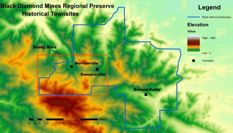
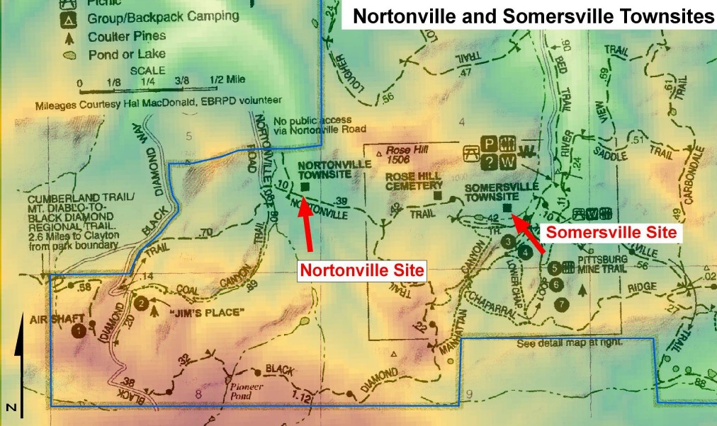
Introduction The Nortonville California area was the largest coal mining complex in the state’s history. From the late 1960’s through the turn of the century, the area produced coal for Bay Area industries http://www.ebparks.org/parks/black.htm. Located three miles south of Antioch California in the eastern Bay Area, it has become a popular recreational area. The area is now known as the Black Diamond Mines Regional Preserve, an area which is managed by the East Bay Regional Park District (EBRPD). The park covers 5,717 acres in the rugged northern foothills of Mount Diablo (http://www.ebparks .org). Although there are no remaining traces of the city itself, there is still evidence of the human influence in the area. Points of historical interest include; several mining sites, Rose Hill Cemetery, miles of recreational trails, and a seasonally opened museum in an old mine. Since I visited the park in the winter of 2005, I have read all major published works written about the area. The only map readily available to the public is the small brochure available at the trailhead. Although the map is well done, it did not answer my basic question of what was the extent of the towns Nortonville and Somersville California. | |
| |
|
Background Between the 1860’s and 1902 the mines on the northern foothills of Mount Diablo California produced an estimated 20 million dollars worth of coal (Purcell, 1940). During that period five towns were established based upon the coal industry. The towns of Nortonville and Somersville were the largest. The most extensively written work available to the public is the book “History of Contra Costa County”, by Mae Purcell. In the book, a brief chapter details coal industry during that period. The book is well written, however it lacks any maps.What sparked my interest in the actual location of the town sites were several pictures in the above mentioned book. The pictures gave me an idea of the layout of Nortonville. However as already explained, there were no maps readily available to give me the actual layout of both Nortonville and Somersville. | |
| |
|
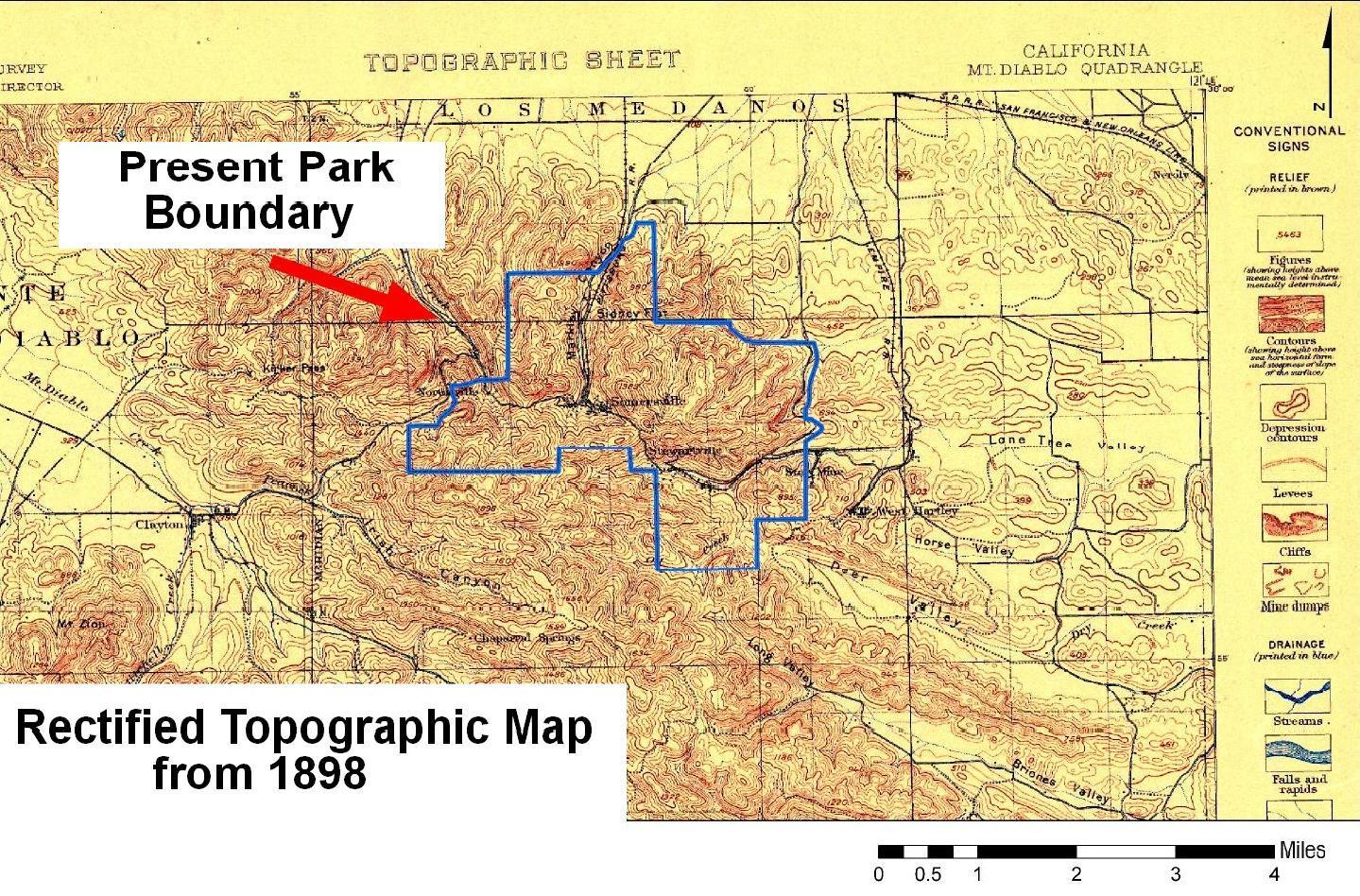
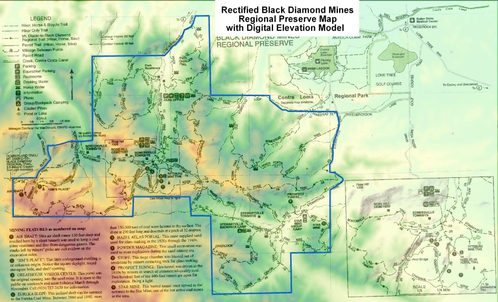
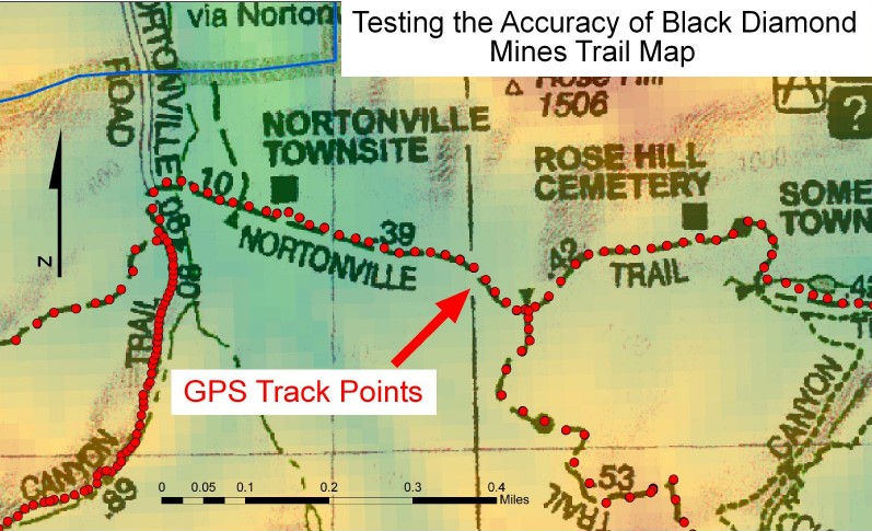
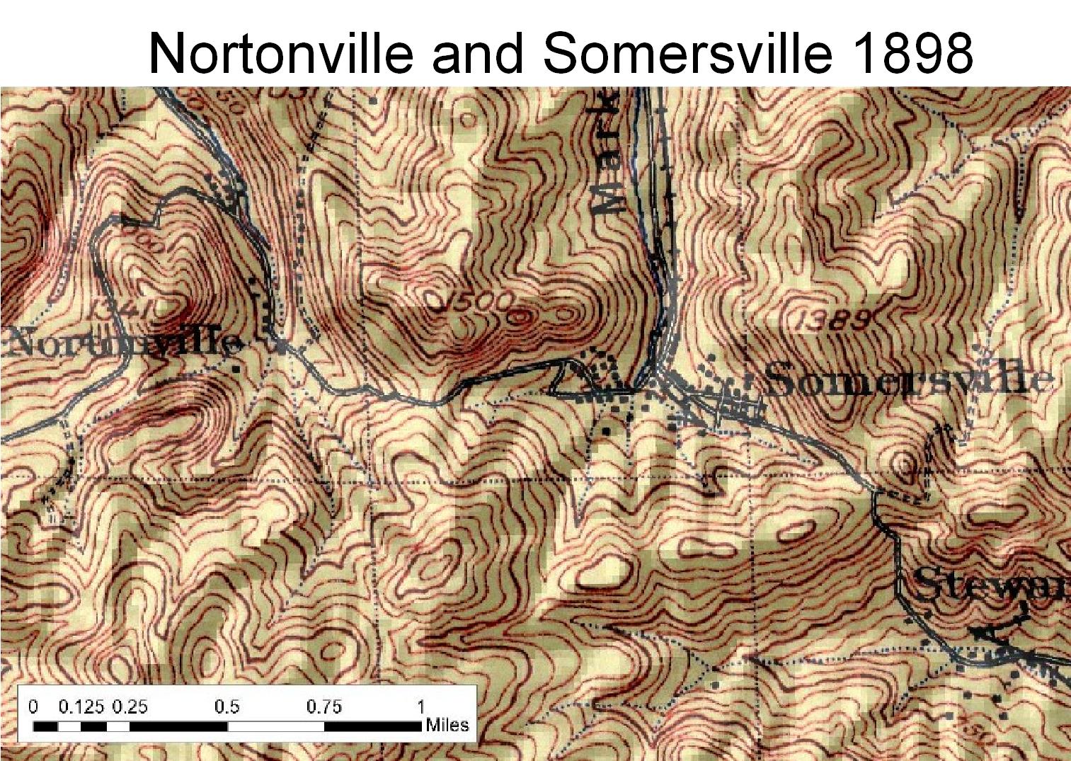
Methods I employed several methods for acquiring data for this project: The first of which was to do research in finding all maps available to the public on the internet. I found an archived 1:62,500 USGS Topographic map from 1898 at the USGS website. It is located at the USGS’s San Francisco Bay Area Regional Database (BARD) http://bard.wr.usgs.gov/. This USGS Topographic shows the layout of both Nortonville and Somersville and was surveyed in 1896. I also used the Black Diamond Mines Regional Preserve map. This map is available from East Bay Regional Park District (EBRPD). It can be obtained on paper at the park and in .pdf format at their website http://www.ebparks.org. I then scanned the map so I could extract the boundary information in ArcGIS 9.0. The next step I did was to rectify both maps using the georeferencing tool included in ESRI’s ArcGIS 9.0. Both maps were rectified from a USGS Topographic map 1:24k mosaic obtained from California Spatial Information Library (CASIL) at http://gis.ca.gov. After this process, I spent two days obtaining GPS data using a Garmin 76S. I collected waypoints and tracks in the vicinity of the two town sites. The waypoints were of historical features and the tracks were used to map several trails around Nortonville and Somersville. Once I rectified the two maps, I then added my GPS points to validate the accuracy of the Black Diamond Mines Preserve map. I then used ArcGIS 9.0 and Freehand 8.0.1 from Macromedia to create maps of the entire data acquisition process. | |
Data Input | |
| |
Data Input | |
| |
|
Results I found that the Black Diamond Mines map is highly accurate with point locations derived from USGS Topographic maps. The trails within the park were almost identical to my own information gathered with my Garmin 76S. | |
| |
Validation of data using a GPS | |
| |
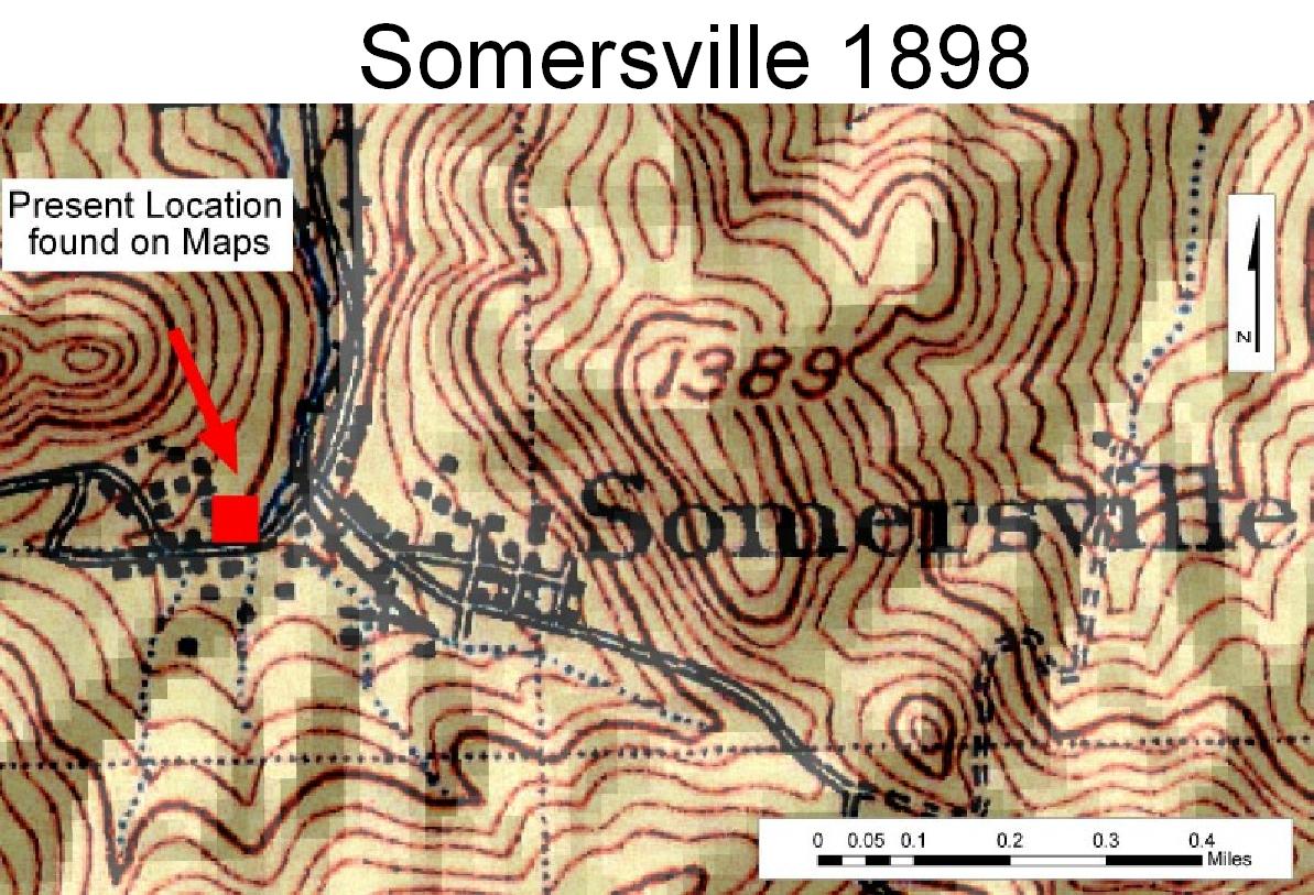
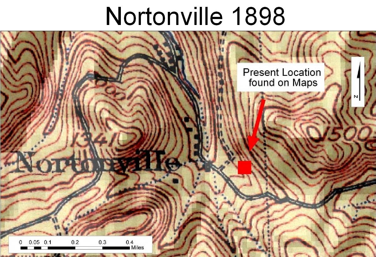
Results of Data Acquisition: Layout of Townsites | |
| |
|
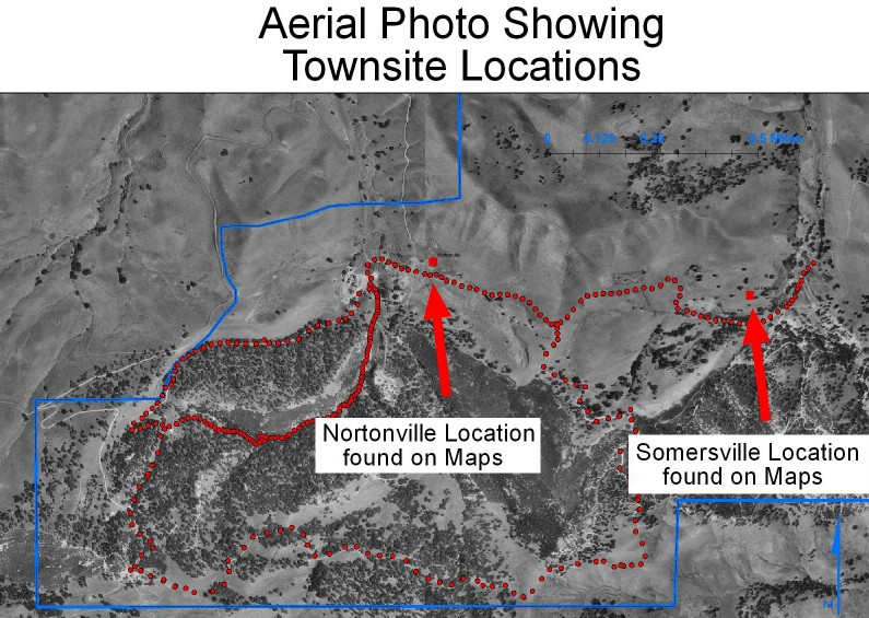
The second result of my data acquisition and analysis was that Nortonville at the time of production of the USGS’s 1898 map was not in the same position as marked on the Black Diamond Mines map. | |
| |
Results of Data Acquisition: Layout of Townsites | |
| |
|
Analysis The methods employed during this project turned out to be successful in validating my hypothesis. The rectified maps provided accurate information to the location of Nortonville and Somersville during the late 1890’s. What I found most difficult was trying to rectify the USGS 1898 1:24k topographic map. It was difficult because I had to pick different reference points in different locations many times in order to make it match a modern USGS 1:24k topographic map. | |
|
Conclusions The first conclusion is that the town site of Nortonville during the late 1890’s is not in the same location as marked on modern maps. Secondly, the Black Diamond Mines Regional Preserve map is accurate. | |
|
References Purcell, Mae Fisher, 1940. History of Contra Costa County. pg. 355 East Bay Regional Park District. Black Diamond Mines Regional Preserve Map. http://www.ebparks.org United States Geological Survey San Francisco Bay Area Regional Database. (BARD).Mt. Diablo 1:62,500 Topographic Map 1889. http://bard.wr.usgs.gov/ California Spatial Information Library (CASIL). http://gis.ca.gov. | |